

Last modified: 7 June 2021
DISCLAIMER: This English version is translated from the original French. In case of any discrepancy, the French version shall prevail.
| Author: | Gigon et al., 2020 |
| Age: | Neoarchean |
| Stratotype: | None |
| Type area: | Area at the west of Marjoulet Lake (NTS sheet 33F01). |
| Geological province: | Superior Province |
| Geological subdivision: | Opinaca Subprovince |
| Lithology: | Tonalitic to granodioritic gneiss |
| Category: | Lithodemic |
| Rank: | Lithodeme |
| Status: | Formal |
| Use: | Active |
None
Background
The Marjoulet Gneiss was first described following geological mapping work in 2015 (Gigon et al., 2020), where a foliated to banded biotite ± hornblende tonalitic gneiss was observed in the central portion of sheet 33F01. The name refers to Marjoulet Lake located in this area. The 2016 and 2018 summer mapping work extended the unit east and southeast, with new strips of gneiss identified in sheets 33G04 and 33G03, and 33B14.
Description
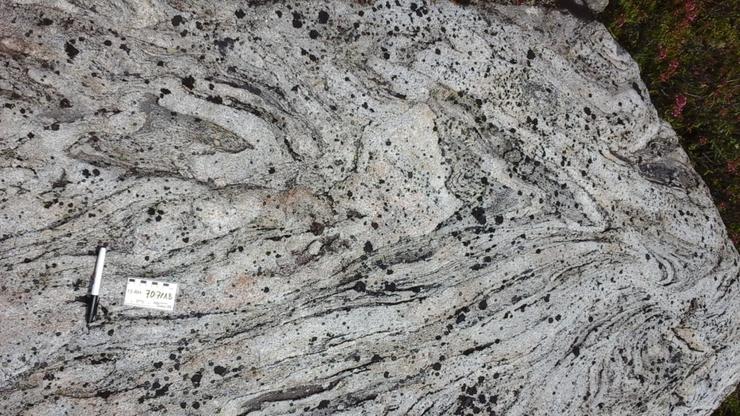

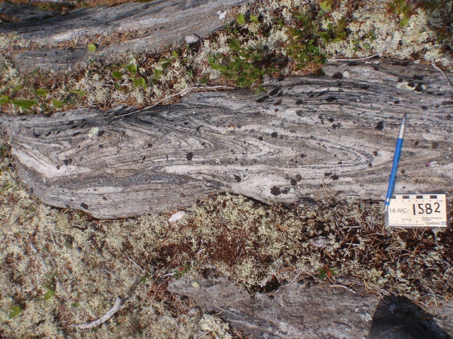
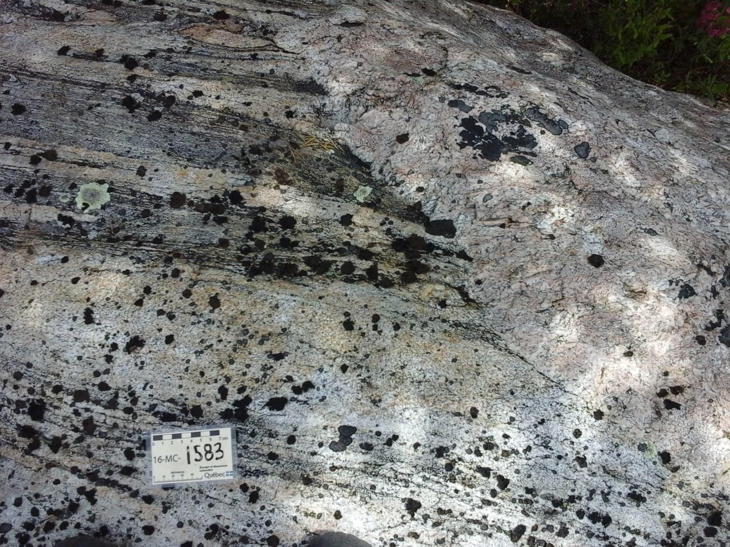
The Marjoulet Gneiss consists mainly of biotite ± hornblende tonalite and granodiorite with a foliated to banded structure. The amount of biotite generally ranges from 2 to 10% and reaches locally 25%. Magnetite (<1%) and hornblende (<8%) are also present. Grain size varies from fine to medium. Foliation is highlighted by biotite schlierens. Banding is formed by compositional variations defined by more felsic centimetric bands, more ferromagnesian bands and dioritic horizons, which are usually boudinaged. Enclaves (15 cm to 2 m) and centimetric to metric horizons of amphibolite, paragneiss or ultramafic rock are also observed. A large volume of granitic intrusions is also present in this unit (Gigon et al., 2020).
In the field, the gneissic structure has not always been listed since these rocks’ compositional banding have sometimes been associated with ultrametamorphic granite, banded granite or a foliated tonalite intruded by granite. Furthermore, rock heterogeneity and the presence of biotite schlierens make mineral percentages highly variable and difficult to assess. It is therefore likely that the Marjoulet Gneiss is more widespread than currently known.
Thickness and Distribution
The Marjoulet Gneiss covers an area of about 170 km². It is divided in approximately 20 strips of 3 to 20 km in length and has an apparent thickness of 0.5 to 3 km (Goutier, 2018). Gneiss strips are distinguished by a stronger magnetic susceptibility. Fifteen of these strips can be found in sheets 33B14, 33G03 and 33G06.
Dating
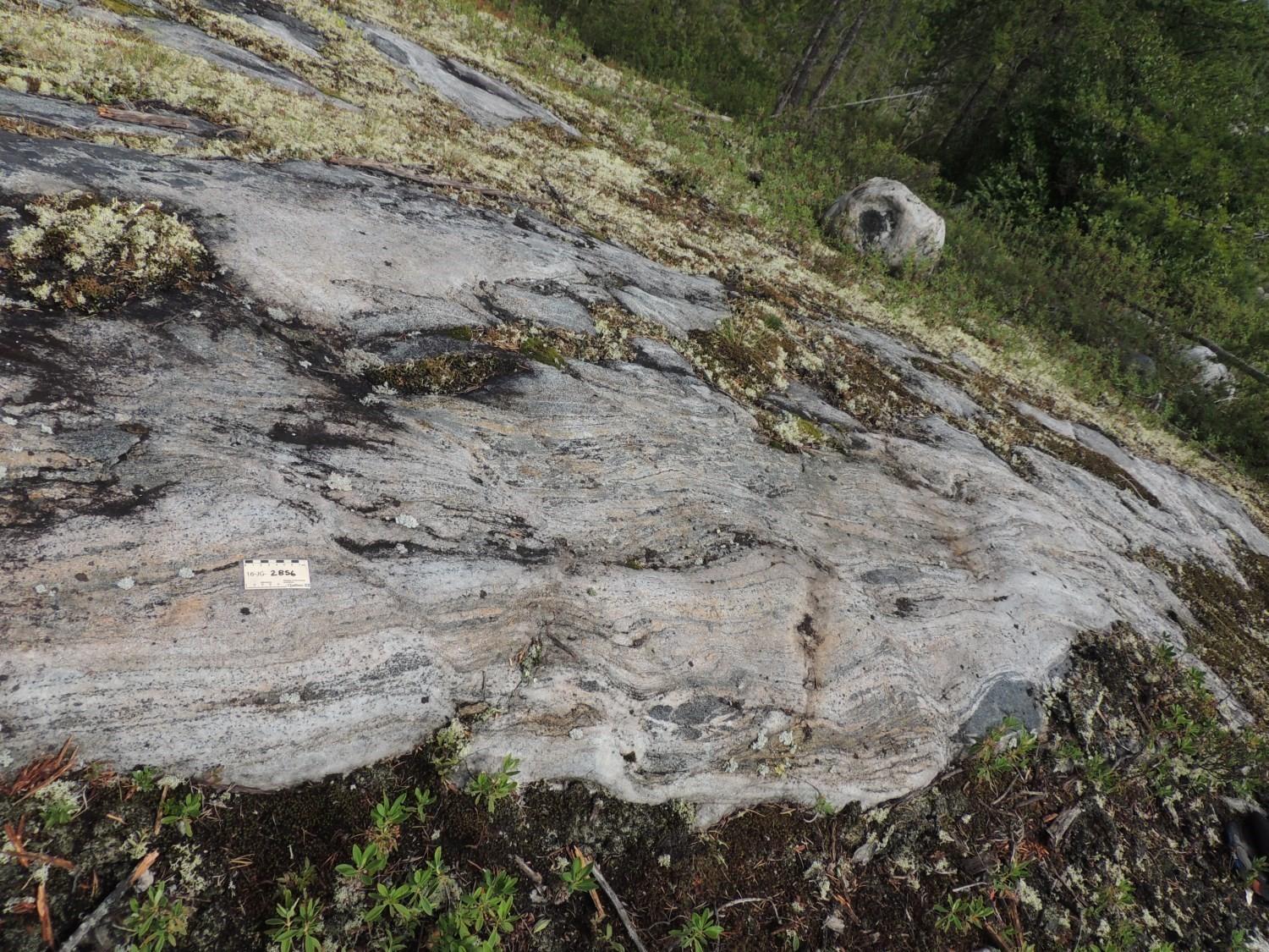
A U-Pb isotopic dating sample was taken from outcrop 2016-JG-2856 located 1.4 km west of Marjoulet Lake.
| Unit | Sample Number | Isotopic System | Mineral | Crystallization Age (Ma) | (+) | (-) | Reference(s) |
| nAgma | 2016-JG-2856B | U-Pb | Zircon | 2689 | 4 | 4 | David, 2018 |
Stratigraphic Relationship(s)
The Marjoulet Gneiss is hosted in units nAlgi2a, nAlgi3a and nAlgi4a of the Laguiche Complex. It is highly deformed and metamorphosed to the amphibolite facies, as are the host rocks. Dioritic intrusions found in the gneiss are younger than the tonalite, but they have also been heavily deformed. The Marjoulet Gneiss is cut by dykes and pegmatitic granite intrusions associated with the Vieux Comptoir Granitic Suite. It is also cut by diabase of the Mistassini Dyke Swarm and Lac Esprit Dykes.
Paleontology
Does not apply.
References
Publications available through SIGÉOM Examine
DAVID, J., 2018. Datations U-Pb dans les provinces de Grenville et du Supérieur effectuées au GEOTOP en 2016-2017. MERN, GEOTOP; MB 2018-17, 22 pages.
GIGON, J., GOUTIER, J., CÔTÉ-ROBERGE, M., 2020. Géologie de la région du lac de Villaret (SNRC 33F01 et 33F08), municipalité d’Eeyou Istchee Baie-James. MERN; RG 2019-01, 42 pages, 1 plan.
GOUTIER, J., 2018. Géologie de la région du lac Ewart, sous-provinces de La Grande et d’Opinaca, à l’est de Radisson, Eeyou Istchee Baie-James, Québec, Canada. MERN; BG 2018-10, 2 plans
Suggested Citation
Ministère de l’Énergie et des Ressources naturelles (MERN). Marjoulet Gneiss. Quebec Stratigraphic Lexicon. https://gq.mines.gouv.qc.ca/lexique-stratigraphique/province-du-superieur/gneiss-de-marjoulet_en [accessed on Day Month Year].
Contributors
|
First publication |
Alban Duvernois, M.Sc. (redaction) Mehdi A. Guemache, P. Geo., Ph.D. (coordination); Pierre Lacoste, P. Geo., M.Sc. (critical review); Simon Auclair, P. Geo., M.Sc. (editing); Céline Dupuis, P. Geo., Ph.D. (English version); Ricardo Escobar Moran (HTML editing). |