

First published: 2 May 2019
Last modified: 4 August 2020
DISCLAIMER: This English version is translated from the original French. In case of any discrepancy, the French version shall prevail.
| Author(s): | Longley, 1946; Beausoleil and Doucet, 1999 |
| Age: | Neoarchean |
| Stratotype: | Bernetz Lake (type locality) |
| Type area: | NTS sheets 32D16 (NE), 32C13, 32C14 (W), 32E01 (S) and 32F04 (S) |
| Geological province: | Superior Province |
| Geological subdivision: | Abitibi Subprovince |
| Lithology: | Felsic to intermediate intrusive rocks |
| Category: | Lithodemic |
| Rank: | Lithodeme |
| Status: | Formal |
| Use: | Active |
None
Background
Johannes (1918) recognized a whole suite of acid plutonic rocks (granite, granite gneiss, granodiorite, diorite, aplite and pegmatite) in the central part of the Bernetz Intrusion, without its name or precise delineation. Longley (1946) later described the “Bernetz gneiss” in the Castanier area (NTS sheet 32C13) as a medium-grained biotite quartz dioritic gneiss. Tiphane (1959) described the northern portion of the intrusion (sheets 32E01 and 32F04) as either biotite-hornblende granite, or porphyraceous hornblende gneissic granite. The compilation of Delagrave and Masterman (1979, in MER 1984a, b) mentioned the presence in the western part of the intrusion (sheets 32E01 and 32D16) of granodiorite, biotite-hornblende granite, diorite and biotite-hornblende gneiss. Hocq (in MER, 1983) sometimes referred to the « Bernetz pluton », and sometimes to the « Bernetz massif », to describe, still in the western part of the intrusion, a massive, granular and fairly homogeneous biotite ± hornblende tonalite, without mesoscopic or megascopic enclaves. In their classification of plutons of the Abitibi and Pontiac subprovinces, Rive et al. (1990) placed the Bernetz in suite A, which groups pre-tectonic intrusions consisting of a package of dioritic-tonalitic gneiss, quartzofeldspathic gneiss, migmatite and amphibolite. Rive (1994) specifically described the “Bernetz Tonalitic Gneiss Massif” as consisting of biotite, locally biotite-hornblende, tonalitic gneiss and grey quartzofeldspathic gneiss injected by leucotonalite.
The first mention of the name “Bernetz Intrusion” appears in the map of sheet 32D16 of Beausoleil and Doucet (1999, in MRNF, 2010b), where the description is simplified to tonalitic gneiss and tonalite. This description was used by subsequent works in sheets 32C13 (Grant, 2003, in MNRF, 2010a), 32C14 (Grant, 2004, in MNRF, 2010a) and 32E01 (Beausoleil, Chabot and Goutier, 2003, in MNRF, 2010c), and was completed later with the addition of dioritic lithology on the scale 1:250 000 map of sheet 32E (Beausoleil, 2005, in MRNF, 2010c). In sheet 32F04 (the northern part of the intrusion), Rhéaume (2008, in MRNF, 2010a, d) and Rhéaume et al. (2010) described the Bernetz as a unit of white or pink granodiorite with minor amounts of tonalite. In sheets 32D16 and 32E01 (the western part of the intrusion), Deschênes (2011a-f) and Deschênes and Allard (2014) distinguished three informal units: granodiorite, tonalite and tonalitic gneiss (Abrn1); quartz-hornblende porphyritic granodiorite and granite (Abrn2); and porphyritic granite (Abrn3). Recently, Guemache (2020) redefined informal units for the entire Bernetz Intrusion and revised the position of contacts. These redefined units are described below.
The name of the unit refers to Bernetz Lake, located approximately in the centre of the intrusion.
Description
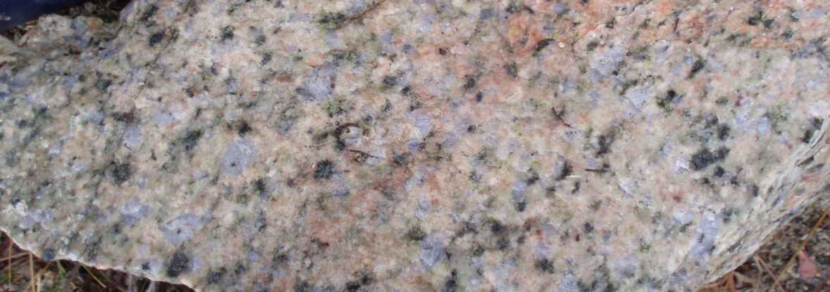
Bernetz Intrusion 1 (nAbrn1): Biotite Granodiorite, Tonalite and Tonalitic Gneiss
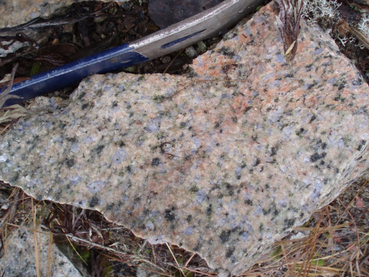


Unit nAbrn1 encompasses massive to gneissic lithologies (granodiorite, tonalite and tonalitic gneiss) where biotite is the principal ferromagnesian mineral. Thin-section observations indicate that this unit is composed of quartz (>20%), locally bluish, plagioclase and K-feldspar (microcline) in varying amounts. Sericitization (muscovite) plagioclase can be relatively intense, while biotite (<15%), which is very sparse in places, is commonly chloritized. Biotite, epidote and chlorite are invariably spatially associated and mark foliation when expressed. Other minerals are titanite, opaque minerals, apatite and, more sparsely, calcite and allanite. A myrmekitic texture is recognized. Epidote is locally abundant, in some cases exceeding biotite. Its pleochroism in the shades of yellow to pistachio green is relatively well marked.
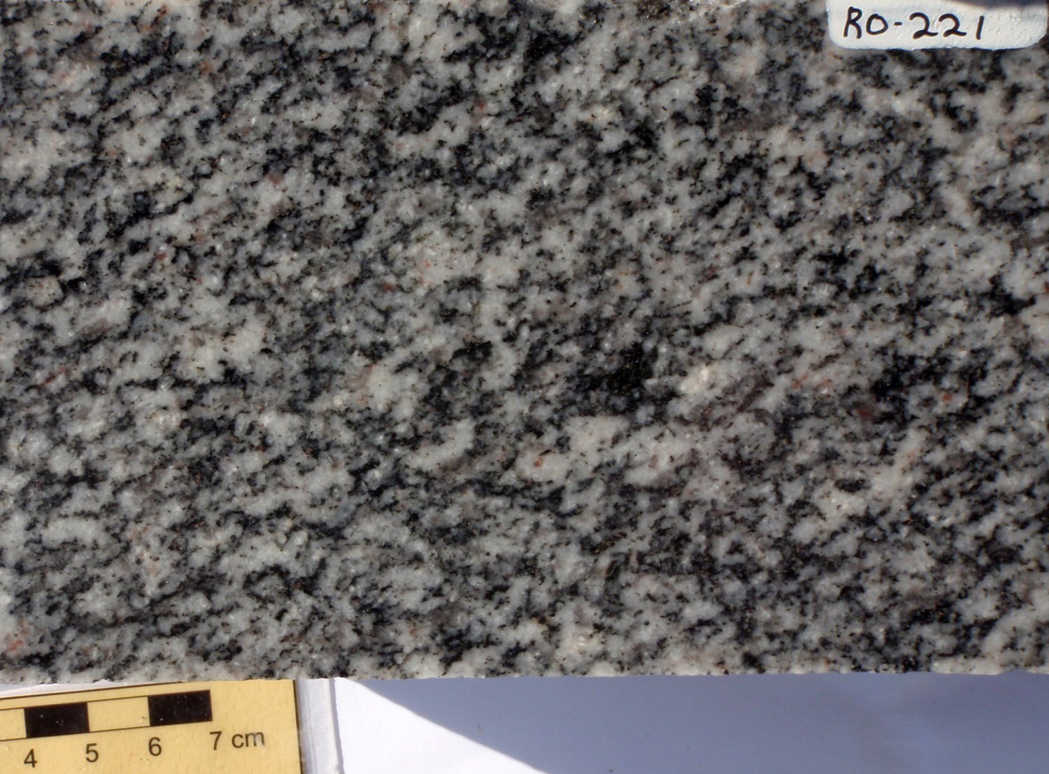
Bernetz Intrusion 2 (nAbrn2): Quartz-Hornblende Porphyritic Granodiorite and Granite
Unit nAbrn2 consists of massive, quartz-K-feldspar porphyritic hornblende granodiorite and granite. In thin sections, plagioclase is usually sericitized. Microcline, typically less altered, is more or less abundant (>15%). Hornblende, commonly poikilitic, accounts for up to 5% of the rock volume. Biotite is absent. Other minerals observed are chlorite, epidote, including allanite, apatite and opaque minerals. A myrmekitic texture is locally observed.
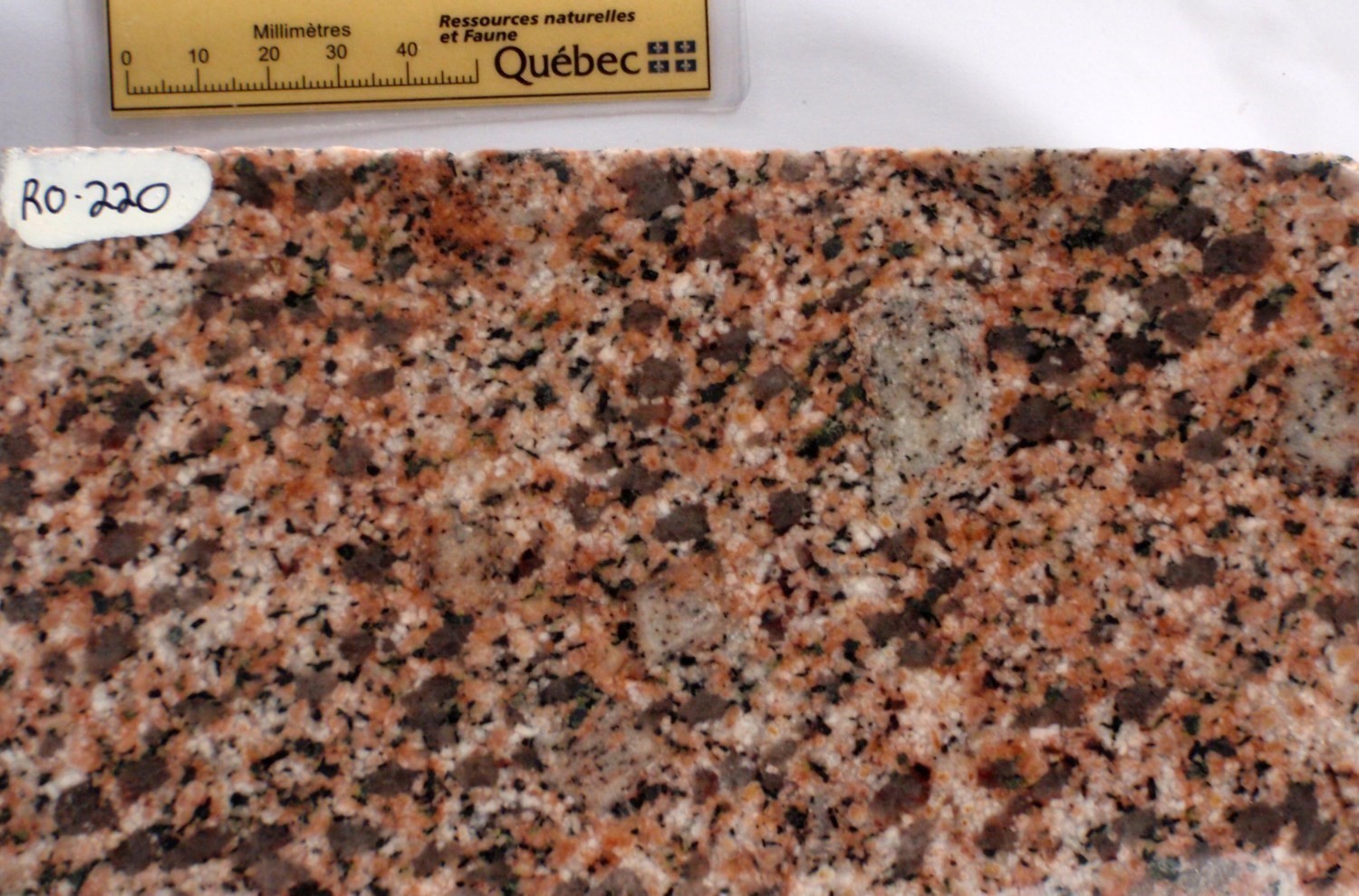
Bernetz Intrusion 3 (nAbrn3): Foliated to Gneissic Biotite-Hornblende Granodiorite
Unit nAbrn3 consists of foliated to gneissic biotite (10%)-hornblende (5%) granodiorite. The rock also contains titanite, which in places occurs as coarse subhedral crystals easily visible to the naked eye, epidote, magnetite and apatite. This unit is clearly visible on the aeromagnetic map (Keating et al., 2010; Keating and d’Amours, 2010) due to its relatively high overall magnetic susceptibility.
Bernetz Intrusion 4 (nAbrn4): Hornblende Diorite and Quartz Diorite

Unit nAbrn4 consists of diorite and quartz diorite containing relatively little quartz (<15%), more or less sericitized plagioclase, poikiloblastic hornblende (10%), commonly chloritized biotite (5%), and locally, clinopyroxene (<3%), chlorite, epidote (allanite), apatite, titanite and magnetite.
Analysis of geochemical data (Guemache, 2020) indicates that the unit nAbrn1 is essentially peraluminous, though some samples are metaluminous. nAbrn2 is metaluminous, while aluminosity of nAbrn3 is unknown; however, the presence of hornblende togheter with biotite tends to indicate a metaluminous magma. These rocks show quite similar rare earth and multielement spectra, marked by an enrichment in light rare earths with respect to heavy rare earths ([La/Sm]NC avg. = 4.13, [La/Yb]NC avg. = 28.96), between 20 and 300 times the chondritic values (McDonough and Sun, 1995), as well as negative anomalies in Ti, Nb and Ta and positive in Zr and Hf. All these rocks would come from a type I magma generated in a tectonic environment comparable to present volcanic arcs (Guemache, 2020).
Thickness and distribution
The Bernetz Intrusion is elongated in a WNW direction and is ~85 km long by 25 km wide for an area of ~2400 km². Its general contour and those of its various phases can be easily identified on regional aeromagnetic maps (Keating et al., 2010; Keating and d’Amours, 2010).
Dating
K-Ar dating on biotites of a Bernetz Intrusion granite sample indicates a cooling age of 2584 ±70 Ma (Wanless et al., 1966; age recalculated to decay constants of Steiger and Jäger, 1977). On the other hand, according to Rhéaume et al. (2010), this intrusion would cut the Glandelet sedimentary formation which has a maximum sedimentation age of 2695 Ma (Rhéaume et al., 2010). The Bernetz Intrusion would therefore be younger than this age.
| Unit | Sample Number | Isotopic System | Mineral | Crystallization Age (Ma) | (+) | (-) |
| nAbrn1 | 63-RF-500 | K-Ar | Biotite | 2584 | 70 | 70 |
Stratigraphic Relationship(s)
The Bernetz Intrusion intrudes into the Desboues Formation. According to Rhéaume et al. (2010), it cuts also the Glandelet Formation.
Paleontology
Does not apply.
References
Publications available through SIGÉOM Examine
DESCHENES, P L. 2011a. GEOLOGIE – GUYENNE. MRNF. CG-32D16A-2011-01, 1 plan.
DESCHENES, P L. 2011b. GEOLOGIE – RIVIERE BERRY. MRNF. CG-32D16D-2011-01, 1 plan.
DESCHENES, P L. 2011c. GEOLOGIE – RIVIERE OCTAVE. MRNF. CG-32D16C-2011-01, 1 plan.
DESCHENES, P L. 2011d. GEOLOGIE – RIVIERE OCTAVE. MRNF. CG-32E01B-2011-01, 1 plan.
DESCHENES, P L. 2011e. GEOLOGIE – RUISSEAU MILLER. MRNF. CG-32E01A-2011-01, 1 plan.
DESCHENES, P L. 2011f. GEOLOGIE – SAINT-DOMINIQUE-DU-ROSAIRE. MRNF. CG-32D16B-2011-01, 1 plan.
DESCHENES, P L., ALLARD, G. 2014. REVISION DE LA GEOLOGIE DE LA REGION DE LA RIVIERE OCTAVE (32D16 ET 32E01). MRN. RP 2014-02, 14 pages.
DESCHENES, P L., ALLARD, G. 2014. GEOLOGICAL REVISION OF THE RIVIERE OCTAVE REGION (NTS 32D16 AND 32E01). MRN. RP 2014-02-A, 1 page.
GUEMACHE, M A. 2020. Synthèse géologique de la région de rivière Octave, Abitibi. MERN. RG 2018-01, 68 pages et 1 plan.
KEATING, P., D’AMOURS, I. 2010. REEDITION DES DONNEES NUMERIQUES EN FORMAT GEOSOFT (PROFILS) DES LEVES AEROPORTES DE L’ABITIBI, AU QUEBEC. MRNF, COMMISSION GEOLOGIQUE DU CAN. DP 2010-09, 6 pages.
KEATING, P., LEFEBVRE, D., RAINSFORD, D., ONESCHUCK, D. 2010. SERIE DES CARTES GEOPHYSIQUES, PARTIES DES SNRC 31, 32, 41 ET 42, CEINTURE DE ROCHES VERTES DE L’ABITIBI, QUEBEC ET ONTARIO. COMMISSION GEOLOGIQUE DU CAN. DP 2010-05, 8 pages and 2 plans.
LONGLEY, W W. 1946. REGION DE CASTAGNIER, COMTE D’ABITIBI-EST. MRN. RG 026, 29 pages and 1 plan.
LONGLEY, W W. 1946. CASTAGNIER MAP-AREA, ABITIBI-EAST COUNTY. MRN. RG 026(A), 29 pages and 1 plan.
M E R. 1983. RAPPORT D’ETAPE DES TRAVAUX EN COURS A LA DIVISION DU PRECAMBRIEN. ET 82-01, 269 pages and 2 plans.
M E R. 1984a. CARTE DE COMPILATION GEOSCIENTIFIQUE – 032D/16. CG 032D/16, 16 plans.
M E R. 1984b. CARTE DE COMPILATION GEOSCIENTIFIQUE – 032E/01. CG 032E/01, 16 plans.
MRNF. 2010a. CARTE(S) GÉOLOGIQUE(S) DU SIGEOM – feuillet 32c. CG SIGEOM32C, 49 plans.
MRNF. 2010b. CARTE(S) GÉOLOGIQUE(S) DU SIGEOM – feuillet 32d. CG SIGEOM32D, 56 plans.
MRNF. 2010c. CARTE(S) GÉOLOGIQUE(S) DU SIGEOM – feuillet 32e. CG SIGEOM32E, 57 plans.
MRNF. 2010d. CARTE(S) GÉOLOGIQUE(S) DU SIGEOM – feuillet 32f. CG SIGEOM32F, 64 plans.
RHEAUME, P., MAURICE, C., PARENT, M., MCNICOLL, V. 2010. GEOLOGIE DE LA REGION DE LA RIVIERE BIGNIBA (PARTIES DES SNRC 32F03, 32F04 ET 32C13). MRNF. MB 2010-06, 47 pages and 1 plan.
RIVE, M. 1994. INVENTAIRE DES ROCHES GRANITOIDES DES SOUS-PROVINCES DE L’ABITIBI ET DU PONTIAC. MRN. MB 92-14, 184 pages and 1 plan.
TIPHANE, M. 1959. REGION DE CHASTE – MAZARIN, DISTRICT ELECTORAL D’ABITIBI-EST. MRN. RG 088, 28 pages and 1 plan.
TIPHANE, M. 1959. CHASTE – MAZARIN AREA, ABITIBI-EAST ELECTORAL DISTRICT. MRN. RG 088(A), 24 pages and 1 plan.
Other publications
Joannes, A. 1918. Harricanaw-Turgeon Basin, Abitibi, Timiskaming and Pontiac, Quebec, Geological Survey of Canada, « A » Series Map 183A, 1918, 1 sheet. https://doi.org/10.4095/107525
MacDonough, W.F., Sun, S.-S., 1995. The composition of the Earth. Chemical Geology; volume 120, pages 223-253. https://doi.org/10.1016/0009-2541(94)00140-4
Rive, M., Pintson, H., Ludden, J.N. 1990. Characteristics of late Archean plutonic rocks from the Abitibi and Pontiac Subprovinces, Superior Province, Canada. In: the Northwestern Quebec Polymetallic Belt. (Éditeurs : M. Rive, P. Verpaelst, J. Gagnon, J.-M. Lulin, G. Riverin et A. Simard). Canadian Institute of Mining and metallurgy; Special Volume 43, pages 65-76.
Steiger, R.H., Jager, E. 1977. Subcommission on geochronology: Convention on the use of decay constants in geo- and cosmochronology. Earth and Planetary Science Letters 36(3): 359-36. https://doi.org/10.1016/0012-821X(77)90060-7
Wanless, R. K., Stevens, R. D., Lachance, G. R., Rimsaite, J. Y. H. 1966. Age determinations and geological studies K-Ar isotopic ages, Report 6, Geological Survey of Canada, Paper 65-17, 1966, 109 pages (1 sheet). https://doi.org/10.4095/100990
Suggested Citation
Ministère de l’Énergie et des Ressources naturelles (MERN). Bernetz Intrusion. Quebec Stratigraphic Lexicon. http://gq.mines.gouv.qc.ca/lexique-stratigraphique/province-du-superieur/intrusion-de-bernetz_en [accessed on Day Month Year].
Contributors
|
First publication |
Mehdi A. Guemache, P. Geo., Ph.D. mehdi.guemache@mern.gouv.qc.ca (redaction and coordination) Pierre Lacoste, P. Geo., M.Sc. (critical review); Claude Dion, Eng., M.Sc. (editing); Céline Dupuis, P. Geo., Ph.D. (English version); Nathalie Bouchard (HTML editing). |