


First published: 30 May 2019
Last modified:
DISCLAIMER: This English version is translated from the original French. In case of any discrepancy, the French version shall prevail.
| Author(s): | Simard et al., 2008 |
| Age: | Neoarchean |
| Stratotype: | None |
| Type area: | Klotz Lake and Pingualuit Crater area (NTS sheets 35A and 35H) |
| Geological province: | Superior Province |
| Geological subdivision: | Minto Subprovince |
| Lithology: | Volcano-sedimentary rocks |
| Category: | Lithodemic |
| Rank: | Complex |
| Status: | Formal |
| Use: | Active |
None
Background
Stevenson et al. (1969) noted the presence of two thin strips of volcanic rocks inside the predominantly granitic rocks of southern Nantais Lake, north of Klotz Lake (sheets 35A and 35B). Taylor (1981) subsequently mapped a small unit of amphibolite and metasedimentary rocks on the shoreline of the NW end of Nantais Lake (sheet 35G01). As a result of their reconnaissance work, Percival et al. (1997a) defined sequences of metavolcanic supracrustal rocks (amphibolite and mafic gneiss) and paraschists in the Nantais Lakes area that were included in the Pélican-Nantais belt. (Percival et al., 1997b). Subsequently, Madore et al. (2001, 2002b) introduced the term “Pélican-Nantais Complex” to group rocks of the Pélican-Nantais belt and some tonalitic intrusions between Klotz Lake and the Pingualuit Crater. They divided the complex into three informal units: paragneiss (Apna1), metavolcanic rocks (Apna2), and tonalite (Apna3). The Pélican-Nantais Complex was extended southward in the Pélican Lake area (sheet 34P) (Cadieux et al., 2002, 2004). The Nantais belt referred to rocks of the Pelican-Nantais Complex in the Nantais and Klotz lakes area (sheets 35A and 35B; Madore et al., 2001, 2002b), while the Pélican belt represented rocks of the same complex in the Pélican Lake area (sheet 34P; Cadieux et al., 2002, 2004).
Simard et al. (2008) divided the Pélican-Nantais Complex into two separate complexes because of the different ages obtained in the Nantais (2775 Ma) and Pelican (2740-2733 Ma) belts: the Nantais and Pélican complexes, respectively. These authors assigned the Caumartin and Peltier belts (metavolcanics) and Headwind Belt (metamorphosed volcano-sedimentary rocks) as defined by Madore et al. (2002a, 2004) to the Nantais Complex based on the resemblance of lithological assemblages (Madore, personal communication). Finally, they reassigned tonalites of the Pélican-Nantais Complex (unit Apna3) defined by Madore et al. (2001, 2002b) to the Kapijuq Suite. These authors also mentioned that tonalites of the Pélican-Nantais complex and tonalites of the Kapijuq suite could be equivalent. As a result of these adjustments, the term “Pélican-Nantais Complex”, as well as the Caumartin, Peltier, Headwind and Nantais belts were abandoned.
| Actual Unit | Simard (2008) | Simard et al. (2008) | Madore et al. (2002a, 2004) | Cadieux et al. (2002, 2004) | Madore et al. (2001, 2002b) | Percival et al. (1997a) |
| Pélican Complex (nApel) | Pélican Complex (Apel) | Pélican Complex (Apel) |
Pélican-Nantais Complex (Apna1-Apna3) Pélican belt |
Ap, Adx, Ard and Afs | ||
| Nantais Complex (nAnan) | Nantais Complex (Anan) | Nantais Complex (Anan) |
Pélican-Nantais Complex (Apna1-Apna3) Nantais belt |
Am | ||
| Caumartin Belt (Acau) | ||||||
| Peltier Belt (Aplt) | ||||||
| Headwind Belt (Ahea) |
Description
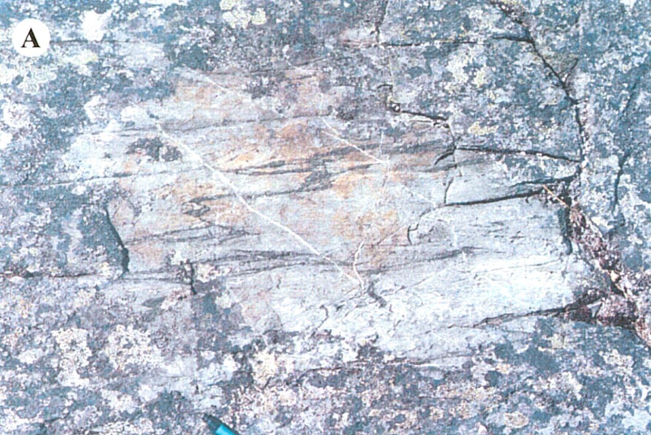
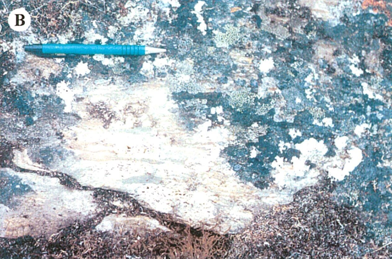
The Nantais Complex comprises several volcanic belts metamorphosed to the amphibolite and granulite facies (Percival et al., 1997a, b; Madore et al., 2001, 2002b; Cadieux et al., 2002, 2004; Simard et al., 2008; Simard, 2008; Lamothe and Simard, 2010, 2011). Metavolcanics are mainly composed of metabasalt and mafic gneiss of tholeiitic affinity. On outcrops, metabasalt has penetrative foliation, while mafic gneiss displays centimetric compositional banding. The most deformed rocks, especially on the edges of klippes, have a mylonitic or straight gneiss fabric. Metabasalt and mafic gneiss contain 5 to 20% felsic mobilisate (granitic and tonalitic material) injected as discontinuous veins, millimetre to centimetre-thick, parallel to gneissosity. They are locally interstratified in various tuff layers of intermediate to felsic composition, with conglomerates and, in places, 1-10 m thick layers of massive to foliated ultramafic rocks (volcanics or sills) or very migmatized paragneiss (>20% granitic mobilisate).
In thin sections, metabasalt and mafic gneiss are fine to medium grained and have a well-developed granoblastic texture. The major mineral phases are green hornblende (60-80%) and plagioclase (10-20%). Clinopyroxene, orthopyroxene, olivine, and garnet and biotite porphyroblasts are observed in places. There are also small amounts of sphene and disseminated opaque minerals (magnetite or pyrite, 1-5%), as well as secondary minerals associated with hydrothermal alteration such as quartz, carbonates and epidote. In a few places, traces of chalcopyrite and native copper are observed. Three volcanogenic massive sulphide-like gold showings were found in the Nantais Lake area (Nantais 1, Nantais 2 and Cabane), suggesting a prospective environment for this type of mineralization (Labbé and Lacoste, 2001).
Thickness and distribution
The Nantais Complex groups four volcano-sedimentary belts elongated along an N-S axis. The latter outcrops between the Vergons Lake area to the north (sheet 34H04) and Couture Lake area to the south (sheet 35B03) as thin klippes a few kilometres thick, up to nearly 40 km long. The belt known as the Headwind Belt (Cadieux et al., 2002, 2004) forms pockmarks (tight synforms) between Nantais Lake and Headwind Lake (sheets 35G01 to 35B10).
Dating
U-Pb dating on zircons of a felsic volcaniclastic rock of the Nantais belt (sheet 35A13) yielded an age of 2775 ±5 Ma, interpreted as the age of emplacement (David et al., 2009). Within 1 km, a staurolite schist at the edge of the klippe yielded a metamorphic age of 2703 ±1 Ma (Percival and Skulski, 2000).
| Unit | Sample Number | Isotopic System | Mineral | Crystallization Age (Ma) | (+) | (-) | Metamorphic Age (Ma) | (+) | (-) | Reference(s) |
| nAnan | 00-LM-1127-A | U-Pb | Zircon | 2775 | 5 | 5 | David et al., 2009 | |||
| PBA-95-1538C | U-Pb | Zircon | 2703 | 1 | 1 | Percival and Skulski, 2000 |
Stratigraphic Relationship(s)
The Nantais Complex consists of volcano-sedimentary belts hosted in younger granitoids. It appears to be associated with major volcanism contemporary to the emplacement of large tonalite units (Rochefort, Kapijuq and Faribault-Thury suites) which affected the northern Minto Subprovince between 2790 and 2760 Ma (Simard et al., 2008).
Paleontology
Does not apply.
References
Publications Available Through SIGÉOM Examine
CADIEUX, A M., BERCLAZ, A., LABBE, J Y., LACOSTE, P., DAVID, J., SHARMA, K.N.M. 2002. GEOLOGIE DE LA REGION DU LAC PELICAN (34P). MRN. RG 2002-02, 50 pages and 1 plan.
CADIEUX, A M., BERCLAZ, A., LABBE, J Y., LACOSTE, P., DAVID, J., SHARMA, K N M. 2004. GEOLOGY OF THE LAC DU PELICAN AREA (34P). MRNFP. RG 2002-08, 48 pages and 1 plan.
DAVID, J., MAURICE, C., SIMARD, M. 2009. DATATIONS ISOTOPIQUES EFFECTUEES DANS LE NORD-EST DE LA PROVINCE DU SUPERIEUR - TRAVAUX DE 1998, 1999 ET 2000. MRNF. DV 2008-05, 92 pages.
LABBE, J Y., LACOSTE, P. 2001. ENVIRONNEMENTS PROPICES AUX MINERALISATIONS POLYMETALLIQUES DE TYPE VOLCANOGENE DANS LE GRAND-NORD QUEBECOIS. MRN. MB 2001-07, 83 pages.
LAMOTHE, D., SIMARD, M. 2010. COMPILATION GEOLOGIQUE DE L'OROGENE DE L'UNGAVA (VERSION PRELIMINAIRE). MRNF. RP 2010-05, 1 page and 1 plan.
LAMOTHE, D., SIMARD, M. 2011. GEOLOGICAL COMPILATION OF THE UNGAVA OROGEN (PRELIMINARY VERSION). MRNF. RP 2010-05(A), 1 page.
MADORE, L., LARBI, Y., LABBE, J Y., SHARMA, K.N.M., LACOSTE, P., DAVID, J. 2002a. GEOLOGIE DE LA REGION DU LAC COUTURE (35B) ET DES LACS NUVILIK (35G, PARTIE SUD). MRN. RG 2002-04, 45 pages and 2 plans.
MADORE, L., LARBI, Y., LABBE, J Y., SHARMA, K N M., LACOSTE, P., DAVID, J. 2004. GEOLOGY OF THE LAC COUTURE (35B) AND LACS NUVILIK (35G, SOUTHERN HALF) AREAS. MRNFP. RG 2003-02, 42 pages and 2 plans.
MADORE, L., LARBI, Y., SHARMA, K.N.M., LABBE, J Y., LACOSTE, P., DAVID, J., BROUSSEAU, K., HOCQ, M. 2001. GEOLOGIE DE LA REGION DU LAC KLOTZ (35A) ET DU CRATERE DU NOUVEAU QUEBEC (1/2 SUD DE 35H). MRN. RG 2001-09, 46 pages and 2 plans.
MADORE, L., LARBI, Y., SHARMA, K N M., LABBE, J Y., LACOSTE, P., DAVID, J., BROUSSEAU, K., HOCQ, M. 2002b. GEOLOGY OF THE LAC KLOTZ (35A) AND THE CRATERE DU NOUVEAU-QUEBEC (SOUTHERN HALF OF 35H) AREAS. MRN. RG 2002-05, 45 pages and 2 plans.
MRNF 2008a. COMPILATION GEOLOGIQUE 1/250 000, 35A - LAC KLOTZ. In : MRNF. 2010. CARTE(S) GÉOLOGIQUE(S) DU SIGEOM - feuillet 35a. CG SIGEOM35A, 1 plan.
MRNF 2008b. COMPILATION GEOLOGIQUE 1/250 000, 35B - LAC COUTURE. In : MRNF. 2010. CARTE(S) GÉOLOGIQUE(S) DU SIGEOM - feuillet 35b. CG SIGEOM35B, 1 plan.
MRNF 2007a. GEOLOGIE 1/50 000 - 35G01 - LAC FLAHERTY. In : MRNF. 2010. CARTE(S) GÉOLOGIQUE(S) DU SIGEOM - feuillet 35g. CG SIGEOM35G, 16 plans.
MRNF 2007b. GEOLOGIE 1/50 000 - 35G02 - LAC NAWRY. In : MRNF. 2010. CARTE(S) GÉOLOGIQUE(S) DU SIGEOM - feuillet 35g. CG SIGEOM35G, 16 plans.
MRNF 2007c. GEOLOGIE 1/50 000 - 35G07 - LAC DUMAS. In : MRNF. 2010. CARTE(S) GÉOLOGIQUE(S) DU SIGEOM - feuillet 35g. CG SIGEOM35G, 16 plans.
MRNF 2007d. GEOLOGIE 1/50 000 - 35H04 - LAC VERGONS. In : MRNF. 2010. CARTE(S) GÉOLOGIQUE(S) DU SIGEOM - feuillet 35h. CG SIGEOM35H, 16 plans.
MRNF 2007e. GEOLOGIE 1/50 000 - 35H05 - CRATERE DU NOUVEAU-QUEBEC. In : MRNF. 2010. CARTE(S) GÉOLOGIQUE(S) DU SIGEOM - feuillet 35h. CG SIGEOM35H, 16 plans.
SIMARD, M. 2008. LEXIQUE STRATIGRAPHIQUE DES UNITES ARCHEENNES DU NORD-EST DE LA PROVINCE DU SUPERIEUR. MRNF. DV 2008-03, 107 pages.
SIMARD, M., LABBE, J Y., MAURICE, C., LACOSTE, P., LECLAIR, A., BOILY, M. 2008. SYNTHESE DU NORD-EST DE LA PROVINCE DU SUPERIEUR. MRNF. MM 2008-02, 198 pages and 8 plans.
Other Publications
PERCIVAL, J.A., SKULSKI, T. 2000. TECTONOTHERMAL EVOLUTION OF THE NORTHERN MINTO BLOCK, SUPERIOR PROVINCE, QUEBEC, CANADA. The Canadian Mineralogist; volume 38, pages 345-378. https://doi.org/10.2113/gscanmin.38.2.345
PERCIVAL, J.A., SKULSKI, T., NADEAU, L. 1997a. Reconnaissance geology of the Pelican-Nantais Belt, northeastern Superior Province. Geological Survey of Canada, Open File 3525, 1 1:250 000 map. https://doi.org/10.4095/209271
PERCIVAL, J.A., SKULSKI, T., NADEAU, L. 1997b. Granite-greenstone terranes for the northern Minto block, northeastern Quebec: Pelican-Nantais, Faribault-Leridon, and Duquet belts. In : Canadian Shield / Bouclier canadien; Geological Survey of Canada, Current Research 1997-C, pages 211-222. https://doi.org/10.4095/208646
STEVENSON, I.M., FAHRIG, W.F., CURRIE, K.L., SCHILLER, A.E., ROACH, T., TAYLOR, F.C., SKINNER, R., BOSTOCK, H.H., WILLIAMS, M.H., MIRYNECH, E. 1969. Geology, Leaf River, Québec. Geological Survey of Canada, "A" Series Map 1229A, 1 sheet. https://doi.org/10.4095/109106
TAYLOR, F.C. 1981. Geology, Nuvilik Lakes, Quebec. Geological Survey of Canada, "A" Series Map 1540A, 1 sheet. https://doi.org/10.4095/109246
Suggested Citation
Ministère de l’Énergie et des Ressources naturelles (MERN). Nantais Complex. Quebec Stratigraphic Lexicon. https://gq.mines.gouv.qc.ca/lexique-stratigraphique/province-du-superieur/complexe-de-nantais_en [accessed on Day Month Year].
Contributors
|
First publication |
Céline Dupuis, P. Geo., Ph.D. celine.dupuis@mern.gouv.qc.ca (redaction, French and English versions) Mehdi A. Guemache, P. Geo., Ph.D. (coordination); Charles St-Hilaire, GIT, M.Sc. (critical review and editing); André Tremblay (HTML editing). |