

First published: 14 February 2020
Last modified:
DISCLAIMER: This English version is translated from the original French. In case of any discrepancy, the French version shall prevail.
| Author(s): | Leclair et al., 2000 |
| Age: | Neoarchean |
| Stratotype: | None |
| Type area: | La Potherie Lake area (NTS sheet 34I) |
| Geological province: | Superior Province |
| Geological subdivision: | Minto Subprovince |
| Lithology: | Gneissic tonalite |
| Category: | Lithodemic |
| Rank: | Suite |
| Status: | Formal |
| Use: | Active |
None
Background
The Rochefort Suite was officially introduced by Leclair et al. (2000, 2001) to describe a tonalite unit that covers a significant area in the La Potherie Lake area (sheet 34I). Il was extended in the Pélican Lake (sheet 34P; Cadieux et al., 2002, 2004), Vernon Lake (sheet 34J; Parent et al., 2002, 2003), Anuc Lake (sheet 34O; Berclaz et al., 2003, 2005), Couture Lake and Nuvilik Lake (sheets 35B and 35G; Madore et al., 2002, 2004), Kogaluk Bay (sheet 34N; Maurice et al., 2005b), Puvirnituq and Kovik Bay (sheets 35C and 35F; Maurice et al., 2004, 2005a) areas (Simard, 2008). Percival et al. (1995, 1996) identified tonalite lithodemic units in the Qalluviartuuq Lake (sheet 34O) and Couture Lake areas, respectively, but were much smaller in area than the current Rochefort Suite. In the Couture Lake area, Madore et al. (2002, 2004) included a granodiorite unit in the Rochefort Suite that was reassigned to the La Chevrotière Suite by Simard et al. (2008). They also included in the Rochefort Suite most of tonalites assigned to the Rivière aux Feuilles Suite in the Nedlouc Lake area (sheet 34H; Parent et al., 2000, 2001), as well as some tonalites assigned to the Kakiattuq Suite in the Anuc Lake area. They also reassigned to the Favard Suite tonalites of the Kogaluk Bay area that had been assigned to the Rochefort Suite but are located in the Tikkerutuk Domain (Simard, 2008). These amendments allowed to limit the Rochefort Suite in the northern half of the Goudalie Domain and the northern end of the Lac Minto and Tikkerutuk domains (Simard, 2008).
Description
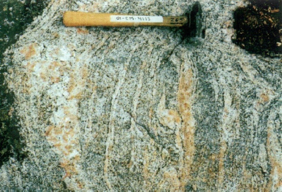
The Rochefort Suite mostly consists of homogeneous to heterogeneous biotite tonalite, with foliation ranging from medium to gneissic, and having a igneous or granoblastic texture (Leclair et al., 2001, 2002; Cadieux et al., 2002, 2004; Madore et al., 2002, 2004; Berclaz et al., 2003, 2005; Maurice et al., 2004, 2005a, 2005b; Simard et al.., 2008; Simard, 2008; MNRF, 2007a-e, 2010a-h). Tonalites of this suite are typically associated with magnetic lows of NW direction. Some 30 mineralized zones, mainly in copper, gold and silver, have been identified in the Rochefort Suite. The latter was divided into three informal units: homogeneous biotite tonalite (nArot 1), heterogeneous hornblende tonalite (nArot2), and heterogeneous granitized tonalite (nArot3) (Madore et al., 2002, 2004; Berclaz et al., 2003, 2005; Maurice et al., 2004, 2005a, 2005b; MNRF, 2007a-e, 2010a-h).
Rochefort Suite 1 (nArot1): Homogeneous Biotite Tonalite
All tonalites grouped in unit nArot1 are homogeneous, ranging from slightly foliated, tectonically banded, to mylonitic. Biotite is the major ferromagnesian phase. Based on grain size and proportion of ferromagnesian minerals, two phases can be differentiated: 1) a medium-grained leucocratic to mesocratic tonalite phase; and 2) a coarse-grained, locally porphyritic white tonalite and trondhjemite phase that has a higher proportion of mafic enclaves. Grey tonalite is composed of plagioclase, quartz and green to brown biotite locally associated with green hornblende and epidote. In thin sections, ferromagnesian minerals (<40%) define foliation. White tonalite is typically heterogranular and is mainly composed of large plagioclase and quartz grains with small interstitial microcline grains. Ferromagnesian minerals (<15%) are dominated by green to red-brown biotite, locally associated with green hornblende and epidote with allanite core. In both phases, secondary minerals are muscovite, sphene, apatite, zircon and leucoxene. Sericite partially or totally replaces plagioclase grains, while chlorite partially replaces biotite. Opaque minerals, usually trace, consist of pyrite and more sparsely magnetite.
The first phase contains only local enclaves of mafic gneiss or amphibolite. These are decimetric to metric and subrrounded to stretched parallel to foliation. In the second phase, mafic enclaves – gabbroic to dioritic in composition – are more abundant; they locally form strings that are likely derived from dismembered sills or dykes.
Rochefort Suite 2 (nArot2): Heterogeneous Hornblende Tonalite
In the Anuc Lake (sheet 34O) and Puvirnituq (sheet 35C) areas, unit nArot2 consists of medium to coarse-grained mesocratic hornblende-rich tonalite, which contains numerous enclaves (<40%) of mafic gneiss and, more locally, ultramafic rocks (Berclaz et al., 2003, 2005; Maurice et al., 2004, 2005a). The many enclaves are stretched and folded in the direction of foliation, giving tonalite a heterogeneous, gneissic appearance. In the Anuc Lake area, this unit forms halos around the different volcano-sedimentary complexes. By moving away from contact with mafic metavolcanic units, the proportion and size of mafic enclaves decrease to thin lenses and hornblende schlierens. These relationships suggest that hornblende tonalite could be the result of disintegration and gradual assimilation of mafic rocks following the injection of tonalitic magma.
Many isolated strips of heterogeneous hornblende tonalite alternate in unit nArot1, but are not visible at the scale of the map. Apart from a greater proportion of hornblende than biotite, microscopic characteristics vary across outcrops and are similar to those observed in the rest of the nArot1 unit. In the most homogeneous facies, hornblende forms phenocrystals with biotite, apatite, sphene and magnetite inclusions. Brown biotite also rims hornblende grains or is intergrown with muscovite. It may contain rutile needles forming a tight mesh. In highly foliated to mylonitic facies, hornblende forms subgrains, or even a neoblastic matrix with plagioclase, quartz and microcline.
Rochefort Suite 3 (nArot3): Heterogeneous Granitized Tonalite

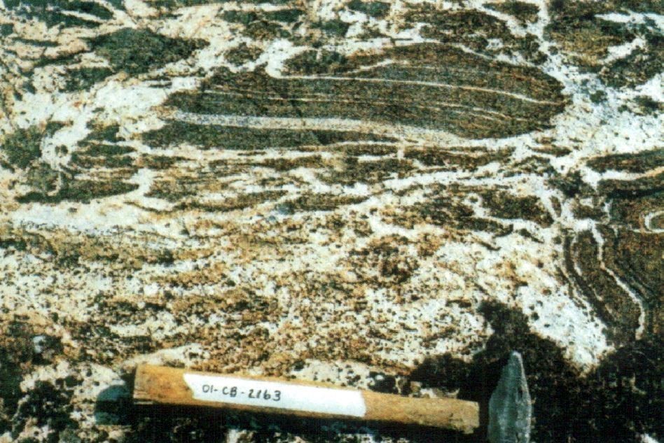
Unit nArot3 differs from the previous two tonalite units by the presence of injections (mass, dyke or vein) of granite material in direct or diffuse contact with the host rock. In the most deformed facies, granite material occurs as decimetric augen clusters or K-feldspar phenocrystals (<10 cm). These granitic bodies are leucocratic to hololeucocratic, medium grained to porphyritic, and the main ferromagnesian mineral observed is biotite. They are similar to later granite and granodiorite units of the La Chevrotière Suite. The unit contains massive to slightly foliated granitic phases, in intrusive and diffuse contact, alternating with augen-textures foliated phases, locally mylonitized, in sharp tectonic contact with tonalites. The absence of a melanocratic interface (melanosome) between granitic and tonalitic phases suggests that granitic bodies represent syn-kinematic injections (La Chevrotière and Pinguq suites) in a tonalitic protolith, equivalent to the unit of homogeneous tonalite (nArot1), rather than metamorphic mobilisates produced during migmatization. In the tonalitic matrix, foliation is commonly marked by muscovite, biotite and epidote. Muscovite forms phenocrystals and neoblasts around plagioclase and biotite.
Thickness and distribution
The Rochefort Suite is located in the NW part of the Minto Subprovince. It covers nine sheets (34I, 34J, 34N, 34O, 34P, 35B, 35C, 35F, 35G) along a general NNW-SSE orientation. The homogeneous biotite tonalite unit (nArot1) is predominant, while the granitized tonalite unit (nArot3) is secondary and discontinuous throughout the suite. Finally, the heterogeneous hornblende unit (nArot2) forms smaller masses a few kilometres to about 50 km in the Anuc Lake (sheet 34O) and Puvirnituq (sheet 35C) areas.
Dating
Several U-Pb and Pb-Pb dating on zircon and titanite (Percival et al., 1996; Skulski et al., 1996; Percival and Skulski, 2000; David et al., 2009; David, 2012), performed in tonalites assigned to the Rochefort Suite, yielded crystallization ages of between 2789 Ma and 2755 Ma (average of ~2770 Ma). A few older U-Pb ages on zircon (inherited ages of 2834 Ma, 2810 Ma and 2799 Ma), as well as Pb-Pb metamorphic ages on titanite between 2691 Ma and 2654 Ma, were also obtained in tonalites assigned to the Rochefort Suite.
| Unit | Sample Number | Isotopic System | Mineral | Crystallization Age (Ma) | (+) | (-) | Inherited Age (Ma) | (+) | (-) | Metamorphic Age (Ma) | (+) | (-) | Reference(s) |
| nArot | PBAC-94-113 | Pb-Pb | Zircon | 2782 | 1.2 | 1.2 | 2799 | 1.9 | 1.9 | Skulski et al., 1996 | |||
| nArot1 | PBAS-95-1738 | U-Pb | Zircon | 2755 | 2 | 2 | Percival and Skulski, 2000 | ||||||
| Pb-Pb | Titanite | 2686 | 1 | 1 | |||||||||
| 2654 | 1 | 1 | |||||||||||
| nArot1 | PBAS-95-1739 | U-Pb | Zircon | 2775 | 5 | 2 | Percival and Skulski, 2000 | ||||||
| Pb-Pb |
Titanite | 2764,5 | 1.7 | 1.7 | |||||||||
| nArot | 99-AL076-A | U-Pb | Zircon | 2767 | 5 | 5 | 2834 | 8 | 8 | David et al., 2009 | |||
| Pb-Pb |
2768 |
7 |
7 |
||||||||||
| Titanite | 2691 | 2 | 2 | ||||||||||
| 2654 | 3 | 3 | |||||||||||
| nArot1 | 01-CH-3067A | U-Pb | Zircon | 2758 | 4 | 4 | 2810 | 4 | 4 | David, 2012 | |||
| nArot | 01-KS-3107A | U-Pb | Zircon |
2789 |
4 | 4 | ~2485-3361 | David, 2012 |
Stratigraphic Relationship(s)
Ages obtained for the Rochefort Suite (between 2789 Ma and 2755 Ma) correspond to a major magmatic event in the NE Superior Province that led to the development of large tonalitic units (Rochefort, Kapijuq and Faribault-Thury suites) between 2800 Ma and 2760 Ma (Simard et al., 2008). A few tonalites, previously included in the Rochefort Suite, indicated ages of 2834 Ma, 2810 Ma and 2799 Ma. These are located in the Duquet (2828-2822 Ma) and Qalluviartuuq-Payne (2850-2830 Ma) volcano-sedimentary complexes, and are interpreted as originating from tonalitic magmatism associated with volcanism of these two complexes (Simard et al., 2008).
Paleontology
Does not apply.
References
Publications Available Through SIGÉOM Examine
BERCLAZ, A., MAURICE, C., LACOSTE, P., DAVID, J., LECLERC, F., SHARMA, K N M., LABBE, J Y., GOULET, N., BEDARD, J., VALLIERES, J. 2003. GEOLOGIE DE LA REGION DU LAC ANUC (34O). MRN. RG 2002-14, 60 pages and 1 plan.
BERCLAZ, A., MAURICE, C., LACOSTE, P., DAVID, J., LECLERC, F., SHARMA, K N M., LABBE, J Y., GOULET, N., BEDARD, J., VALLIERES, J. 2005. GEOLOGY OF THE LAC ANUC AREA (34O). MRNF. RG 2003-05, 55 pages and 1 plan.
CADIEUX, A M., BERCLAZ, A., LABBE, J Y., LACOSTE, P., DAVID, J., SHARMA, K N M. 2002. GEOLOGIE DE LA REGION DU LAC PELICAN (34P). MRN. RG 2002-02, 50 pages and 1 plan.
CADIEUX, A M., BERCLAZ, A., LABBE, J Y., LACOSTE, P., DAVID, J., SHARMA, K N M. 2004. GEOLOGY OF THE LAC DU PELICAN AREA (34P). MRNFP. RG 2002-08, 48 pages and 1 plan.
DAVID, J. 2012. Datations isotopiques effectuées dans le nord-est de la Province du Supérieur (Travaux de 2001, 2002 et 2003). MRNF. DV 2012-05, 84 pages.
DAVID, J., MAURICE, C., SIMARD, M. 2009. DATATIONS ISOTOPIQUES EFFECTUEES DANS LE NORD-EST DE LA PROVINCE DU SUPERIEUR – TRAVAUX DE 1998, 1999 ET 2000. MRNF. DV 2008-05, 92 pages.
LAMOTHE, D., SIMARD, M. 2010. COMPILATION GEOLOGIQUE DE L’OROGENE DE L’UNGAVA (VERSION PRELIMINAIRE). MRNF. RP 2010-05, 1 page and 1 plan.
LAMOTHE, D., SIMARD, M. 2011. GEOLOGICAL COMPILATION OF THE UNGAVA OROGEN (PRELIMINARY VERSION). MRNF. RP 2010-05(A), 1 page.
LAMOTHE, D., THERIAULT, R., LECLAIR, A. 2000. GEOLOGIE DE LA REGION DU LAC NITCHEQUON (23E). MRN. RG 99-14, 46 pages and 1 plan.
LECLAIR, A., PARENT, M., DAVID, J., SHARMA, K N M., DION, D J. 2001. GEOLOGIE DE LA REGION DU LAC LA POTHERIE (34I). MRN. RG 2000-12, 50 pages and 1 plan.
LECLAIR, A., PARENT, M., DAVID, J., SHARMA, K N M., DION, D J. 2002. GEOLOGY OF THE LAC LA POTHERIE AREA. MRN. RG 2001-04, 43 pages and 1 plan.
MADORE, L., LARBI, Y., LABBE, J Y., SHARMA, K N M., LACOSTE, P., DAVID, J. 2002. GEOLOGIE DE LA REGION DU LAC COUTURE (35B) ET DES LACS NUVILIK (35G, PARTIE SUD). MRN. RG 2002-04, 45 pages and 2 plans.
MADORE, L., LARBI, Y., LABBE, J Y., SHARMA, K N M., LACOSTE, P., DAVID, J. 2004. GEOLOGY OF THE LAC COUTURE (35B) AND LACS NUVILIK (35G, SOUTHERN HALF) AREAS. MRNFP. RG 2003-02, 42 pages and 2 plans.
MAURICE, C., BERCLAZ, A., DAVID, J., SHARMA, K N M., LACOSTE, P. 2004. GEOLOGIE DE LA REGION DE POVUNGNITUK (35C) ET DE KOVIK BAY (35F). MRNFP. RG 2003-06, 44 pages and 2 plans.
MAURICE, C., BERCLAZ, A., DAVID, J., SHARMA, K N M., LACOSTE, P. 2005. GEOLOGY OF THE POVUNGNITUK (35C) AND KOVIC BAY (35F) AREAS. MRNF. RG 2004-05, 41 pages and 2 plans.
MAURICE, C., LACOSTE, P., BERCLAZ, A., DAVID, J., SHARMA, K N M. 2005b. GEOLOGIE DE LA REGION DE KOGALUK BAY (34N ET 34M). MRNFP. RG 2004-01, 37 pages and 2 plans.
MRNF 2007a. COMPILATION GÉOSCIENTIFIQUE – GÉOLOGIE 1/50 000, 35F01 – LAC JUET MRNF. 2010. CARTE(S) GÉOLOGIQUE(S) DU SIGEOM – feuillet 35F. CG SIGEOM35F, 16 plans.
MRNF 2007c. COMPILATION GÉOSCIENTIFIQUE – GÉOLOGIE 1/50 000, 35G03 – LAC PELTIER MRNF. 2010. CARTE(S) GÉOLOGIQUE(S) DU SIGEOM – feuillet 35F. CG SIGEOM35F, 16 plans.
MRNF 2007d. COMPILATION GÉOSCIENTIFIQUE – GÉOLOGIE 1/50 000, 35G04 – LAC ALLEMAND MRNF. 2010. CARTE(S) GÉOLOGIQUE(S) DU SIGEOM – feuillet 35G. CG SIGEOM35G, 16 plans.
MRNF 2007e. COMPILATION GÉOSCIENTIFIQUE – GÉOLOGIE 1/50 000, 35G06 – LAC BÉLANGER MRNF. 2010. CARTE(S) GÉOLOGIQUE(S) DU SIGEOM – feuillet 35G. CG SIGEOM35G, 16 plans.
MRNF. 2010a. CARTE(S) GÉOLOGIQUE(S) DU SIGEOM – feuillet 35G. CG SIGEOM35G, 16 plans.
MRNF. 2010b. CARTE(S) GÉOLOGIQUE(S) DU SIGEOM – feuillet 34I. CG SIGEOM34I, 1 plan.
MRNF. 2010c. CARTE(S) GÉOLOGIQUE(S) DU SIGEOM – feuillet 34J. CG SIGEOM34J, 1 plan.
MRNF. 2010d. CARTE(S) GÉOLOGIQUE(S) DU SIGEOM – feuillet 34N. CG SIGEOM34N, 1 plan.
MRNF. 2010e. CARTE(S) GÉOLOGIQUE(S) DU SIGEOM – feuillet 34O. CG SIGEOM34O, 1 plan.
MRNF. 2010f. CARTE(S) GÉOLOGIQUE(S) DU SIGEOM – feuillet 34P. CG SIGEOM34P, 1 plan.
MRNF. 2010g. CARTE(S) GÉOLOGIQUE(S) DU SIGEOM – feuillet 35B. CG SIGEOM35B, 1 plan.
MRNF. 2010h. CARTE(S) GÉOLOGIQUE(S) DU SIGEOM – feuillet 35C. CG SIGEOM35C, 1 plan.
PARENT, M., LECLAIR, A., DAVID, J., SHARMA, K N M. 2000. GEOLOGIE DE LA REGION DU LAC NEDLOUC (SNRC 34H ET 24E). MRN. RG 99-13, 46 pages and 2 plans.
PARENT, M., LECLAIR, A., DAVID, J., SHARMA, K N M. 2001. GEOLOGY OF THE LAC NEDLOUC AREA (NTS 34H AND 24E). MRN. RG 2000-09, 41 pages and 2 plans.
PARENT, M., LECLAIR, A., DAVID, J., SHARMA, K N M., LACOSTE, P. 2002. GEOLOGIE DE LA REGION DU LAC VERNON (34J). MRN. RG 2001-11, 44 pages and 1 plan.
PARENT, M., LECLAIR, A., DAVID, J., SHARMA, K N M., LACOSTE, P. 2003. GEOLOGY OF THE LAC VERNON AREA (34J). MRN. RG 2002-07, 40 pages and 1 plan.
SIMARD, M. 2008. LEXIQUE STRATIGRAPHIQUE DES UNITES ARCHEENNES DU NORD-EST DE LA PROVINCE DU SUPERIEUR. MRNF. DV 2008-03, 107 pages.
SIMARD, M., LABBE, J Y., MAURICE, C., LACOSTE, P., LECLAIR, A., BOILY, M. 2008. SYNTHESE DU NORD-EST DE LA PROVINCE DU SUPERIEUR. MRNF. MM 2008-02, 198 pages and 8 plans.
Other Publications
PERCIVAL, J.A., SKULSKI, T. 2000. Tectonothermal Evolution of The Northern Minto Block, Superior Province, Quebec, Canada. The Canadian Mineralogist; volume 38, pages 345–378. https://doi.org/10.2113/gscanmin.38.2.345
PERCIVAL, J.A., SKULSKI, T., CARD, K.D., LIN, S. 1995. Geology, Rivière Kogaluc-Lac Qalluviartuuq region (parts of 34J and 34O), Quebec. Geological Survey of Canada, Open File 3112, 1 1:50 000 map. https://doi.org/10.4095/205269
PERCIVAL, J.A., SKULSKI, T., NADEAU, L. 1996. Geology, Lac Couture, Quebec. Geological Survey of Canada, Open File 3115, 1 sheet. https://doi.org/10.4095/208195
SKULSKI, T., PERCIVAL, J.A., STERN, R.A. 1996. Archean crustal evolution in the central Minto block, northern Quebec. In: Radiogenic age and isotopic studies: Report 9; Geological Survey of Canada, Curent Research 1995-F, pages 17–31. https://doi.org/10.4095/207760
Suggested Citation
Ministère de l’Énergie et des Ressources naturelles (MERN). Rochefort Suite. Quebec Stratigraphic Lexicon. https://gq.mines.gouv.qc.ca/lexique-stratigraphique/province-du-superieur/suite-de-rochefort_en [accessed on Day Month Year].
Contributors
|
First Publication |
Céline Dupuis, P. Geo., Ph.D. celine.dupuis@mern.gouv.qc.ca (redaction, French and English versions) Mehdi A. Guemache, P. Geo., Ph.D. (coordination); anonymous (critical review); Simon Auclair, P. Geo., M.Sc. (editing); Yan Carette (HTML editing). |