


First published: 30 May 2019
Last modified:
DISCLAIMER: This English version is translated from the original French. In case of any discrepancy, the French version shall prevail.
| Author(s): | Berclaz et al., 2003 |
| Age: | Neoarchean |
| Stratotype: | None |
| Type area: | Anuc Lake area (NTS sheet 34O) |
| Geological province: | Superior Province |
| Geological subdivision: | Minto Subprovince |
| Lithology: | Volcano-sedimentary rocks |
| Category: | Lithodemic |
| Rank: | Complex |
| Status: | Formal |
| Use: | Active |
None
Background
In their mapping of the Kogaluc River and Qalluviartuuq Lake area (NTS sheets 34J and 34O), Percival et al. (1995) identified mafic (Am) and sedimentary (As) metamorphic rocks that would later be assigned to the Mézard Complex, as well as diatexite (Adx) now assigned to the Le Roy Complex. Mafic rocks consist of hornblende-plagioclase amphibolite, locally with preserved pillow textures, and gabbro. They include minor amounts of rhyolite. Metasedimentary rocks consist mainly of paraschist, biotite ± garnet paragneiss, and iron formation.
The Mézard Complex was named and described by Berclaz et al. (2003, 2005) in the Anuc Lake area with reference to nearby Mézard Lake (sheet 34O12). The complex was later extended to the Povungnituk and Kovik Bay (sheets 35C and 35F; Maurice et al., 2004, 2005a) and Kogaluk Bay (sheets 34M and 34N; Maurice et al., 2005b) areas. Initially, this unit was introduced to group remnants of metavolcanic rock (unit Amez1) as well as a significant amount of diatexite derived from advanced melting of paragneiss (unit Amez2). Extending southward, these lithological assemblages were assigned to the Le Roy Complex (Aroy; Parent et al., 2002, 2003; Simard et al., 2005) and the Lac Minto Suite (Amin; Parent et al., 2000, 2001). Simard et al. (2008) redefined the Mézard Complex to group all volcano-sedimentary rock klippes of the Lac Minto Domain. The much younger diatexite, which represents the highly advanced melting product of supracrustal rocks, was reassigned to the Le Roy Complex (nAroy; Simard et al., 2008; Simard, 2008). As a result, the original Amez1 and Amez2 subdivisions used by Berclaz et al. (2003, 2005) and Maurice et al.(2004, 2005a, 2005b) are abandoned.
| Actual Unit | Simard (2008) | Simard et al. (2008) | Simard et al. (2005) | Maurice et al. (2005b) | Maurice et al. (2004, 2005a) | Berclaz et al. (2003, 2005) | Parent et al. (2002, 2003) | Parent et al. (2000, 2001) | Percival et al. (1995) |
| nAmez1 | Amez | Amez | Amez1 | Amez1 | Amez1 | Am | |||
| nAmez2 | Amez | Amez | Aroy1 | Aroy1 | As | ||||
| nAroy1 (Le Roy Complex) | Aroy | Aroy | Aroy3 | Amez2 | Amez2 | Amez2 | Aroy3 | Amin | Adx |
Description
The Mézard Complex consists of volcanic and sedimentary rocks metamorphosed to the amphibolite and granulite facies (Simard et al., 2008; Simard, 2008). It is divided into two informal units (MNRF, 2008a-f): metavolcanic rocks mainly concentrated in the northern half of the complex (nAmez1) and migmatized paragneiss of sedimentary origin located in the southern half (nAmez2). The description of unit nAmez1 is taken from Berclaz et al. (2003, 2005), Maurice et al. (2004, 2005a, 2005b), Simard et al. (2008), Simard (2008) and MNRF (2008a-g), while that of unit nAmez2 is taken from Simard et al. (2008), Simard (2008) and MNRF (2008a-g).
Mézard Complex 1 (nAmez1) : Metavolcanic Rocks of Mafic to Locally Felsic Composition
Metavolcanic rocks of unit nAmez1 consist mainly of hornblende ± biotite ± clinopyroxene ± orthopyroxene amphibolite, although the unit also includes gneiss and mafic schists. Amphibolite is greenish in fresh exposure, brownish in altered surface, massive, foliated or banded. It displays various textures: granoblastic, nematoblastic or lepidoblastic. Foliation is defined by olive-green to brownish green hornblende and locally by orange-brown biotite and very locally by coarse clinopyroxene crystals. Plagioclase is generally altered to sericite and clinozoisite. Accessory minerals include disseminated opaque minerals, apatite, epidote and zircon. The rock is regularly migmatized and is characterized by low amounts (<20%) of clinopyroxene ± orthopyroxene felsic anatectic veins. Klippes of granular mafic rock similar in composition to the volcanics, but rich in magnetite, were observed and mapped occasionally in the Povungnituk and Kovik Bay area. They could represent remnants of metamorphosed ferrobasalt or ferrogabbro units.
Amphibolite is locally associated with metric to decametric layers of intermediate to felsic metavolcanic rocks, which include rhyodacitic tuff interstratified with metasedimentary rocks. Rhyodacitic tuff is even grained, fine grained and granoblastic. It is fully recrystallized and composed mainly of a quartz-plagioclase-microcline assemblage. Deformation occurs through foliation defined by orange-brown biotite and smaller amounts of dark green to brown tourmaline. Muscovite is abundant, while apatite, carbonates, epidote, sphene and zircon complete the mineralogical assemblage.
Mézard Complex 2 (nAmez2) : Migmatized Biotite-Garnet-Cordierite-Sillimanite Paragneiss
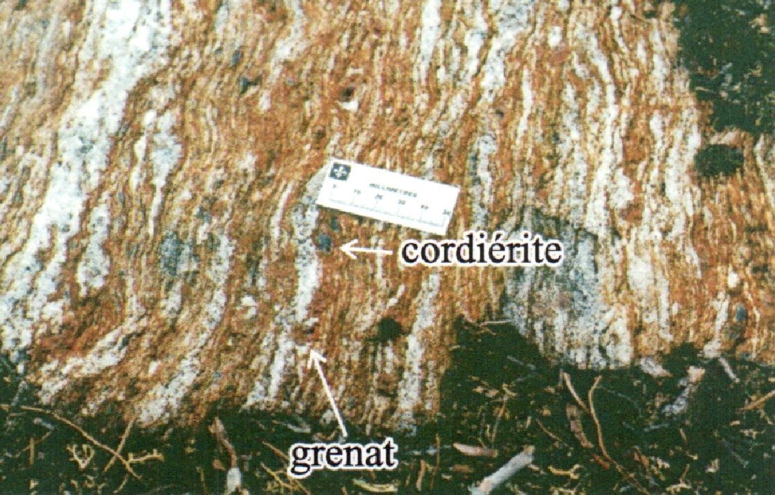
Klippes of sedimentary origin consist mainly of migmatized biotite-garnet-cordierite-sillimanite ± orthopyroxene ± staurolite paragneiss. The rock is brownish grey with a characteristic yellowish brown to rusty-brown alteration patina. It is foliated to banded and fine to medium grained. Intense migmatization results in the presence of centimetric to metric bands of whitish tonalitic to granitic mobilisate that represent up to 50% of the volume of the outcrop. Metric to decametric layers of iron formation are locally associated with paragneiss.
Thickness and distribution
The Mézard Complex consists of lenticular strips <3 km thick and <10 km long enclosed in surrounding granitoids (Simard et al., 2008; Simard, 2008). These strips span nearly 500 km and cover seven sheets (34H, 34G, 34J, 34O, 34N, 35B and 35C). They have a predominantly NW-SE structural orientation to the south, NNW-SSE to the centre and mostly N-S to the north (Maurice et al., 2004, 2005a). Metavolcanic rocks (nAmez1) are concentrated in the northern half of the complex (sheets 34O and 35C mainly), while migmatized paragneiss (nAmez2) is located in the southern half (sheets 34H, 34G and 34J). However, it is likely that migmatitized paragneiss is also abundant in the northern part of the unit, as it has not been differentiated from diatexite (Le Roy Complex) in this area (Simard et al., 2008).
Dating
None.
Stratigraphic Relationship(s)
Volcano-sedimentary rock klippes of the Mézard Complex are enclosed in intrusive rocks of various ages and composition (Simard, 2008). Although their ages are estimated to be between 2760 and 2740 Ma (Simard et al., 2008), it is very likely that the complex contains rocks of different ages. Several supracrustal rock klippes of the Mézard Complex are located near or in the extension of the Kogaluc, Qalluviartuuq-Payne and Duquet complexes, and could therefore be dismembered equivalents of these different units (Simard, 2008).
Paleontology
Does not apply.
References
Publications available through SIGÉOM Examine
BERCLAZ, A., MAURICE, C., LACOSTE, P., DAVID, J., LECLERC, F., SHARMA, K N M., LABBE, J Y., GOULET, N., BEDARD, J., VALLIERES, J. 2003. GEOLOGIE DE LA REGION DU LAC ANUC (34O). MRN. RG 2002-14, 60 pages and 1 plan.
BERCLAZ, A., MAURICE, C., LACOSTE, P., DAVID, J., LECLERC, F., SHARMA, K N M., LABBE, J Y., GOULET, N., BEDARD, J., VALLIERES, J. 2005. GEOLOGY OF THE LAC ANUC AREA (34O). MRNF. RG 2003-05, 55 pages and 1 plan.
MAURICE, C., BERCLAZ, A., DAVID, J., SHARMA, K.N.M., LACOSTE, P. 2004. GEOLOGIE DE LA REGION DE POVUNGNITUK (35C) ET DE KOVIK BAY (35F). MRNFP. RG 2003-06, 44 pages and 2 plans.
MAURICE, C., BERCLAZ, A., DAVID, J., SHARMA, K N M., LACOSTE, P. 2005a. GEOLOGY OF THE POVUNGNITUK (35C) AND KOVIC BAY (35F) AREAS. MRNF. RG 2004-05, 41 pages and 2 plans.
MAURICE, C., LACOSTE, P., BERCLAZ, A., DAVID, J., SHARMA, K.N.M. 2005b. GEOLOGIE DE LA REGION DE KOGALUK BAY (34N ET 34M). MRNFP. RG 2004-01, 37 pages and 2 plans.
MRNF 2008a. COMPILATION GEOLOGIQUE 1/250 000, 34G - LAC MINTO. In : MRNF. 2010. CARTE(S) GÉOLOGIQUE(S) DU SIGEOM - feuillet 34g. CG SIGEOM34G, 1 plan.
MRNF 2008b. COMPILATION GEOLOGIQUE 1/250 000, 34H - LAC NEDLOUC. In : MRNF. 2010. CARTE(S) GÉOLOGIQUE(S) DU SIGEOM - feuillet 34h. CG SIGEOM34H, 1 plan.
MRNF 2008c. COMPILATION GEOLOGIQUE 1/250 000, 34J - LAC VERNON. In : MRNF. 2010. CARTE(S) GÉOLOGIQUE(S) DU SIGEOM - feuillet 34j. CG SIGEOM34J, 1 plan.
MRNF 2008d. COMPILATION GEOLOGIQUE 1/250 000, 34N - KOGALUK BAY. In : MRNF. 2010. CARTE(S) GÉOLOGIQUE(S) DU SIGEOM - feuillet 34n. CG SIGEOM34N, 1 plan.
MRNF 2008e. COMPILATION GEOLOGIQUE 1/250 000, 34O - LAC ANUC. In : MRNF. 2010. CARTE(S) GÉOLOGIQUE(S) DU SIGEOM - feuillet 34o. CG SIGEOM34O, 1 plan.
MRNF 2008f. COMPILATION GEOLOGIQUE 1/250 000, 35B - LAC COUTURE. In : MRNF. 2010. CARTE(S) GÉOLOGIQUE(S) DU SIGEOM - feuillet 35b. CG SIGEOM35B, 1 plan.
MRNF 2008g. COMPILATION GEOLOGIQUE 1/250 000, 35C - POVUNGNITUK. In : MRNF. 2010. CARTE(S) GÉOLOGIQUE(S) DU SIGEOM - feuillet 35c. CG SIGEOM35C, 1 plan.
PARENT, M., LECLAIR, A., DAVID, J., SHARMA, K.N.M. 2000. GEOLOGIE DE LA REGION DU LAC NEDLOUC (SNRC 34H ET 24E). MRN. RG 99-13, 46 pages and 2 plans.
PARENT, M., LECLAIR, A., DAVID, J., SHARMA, K N M. 2001. GEOLOGY OF THE LAC NEDLOUC AREA (NTS 34H AND 24E). MRN. RG 2000-09, 41 pages and 2 plans.
PARENT, M., LECLAIR, A., DAVID, J., SHARMA, K.N.M., LACOSTE, P. 2002. GEOLOGIE DE LA REGION DU LAC VERNON (34J). MRN. RG 2001-11, 44 pages and 1 plan.
PARENT, M., LECLAIR, A., DAVID, J., SHARMA, K N M., LACOSTE, P. 2003. GEOLOGY OF THE LAC VERNON AREA (34J). MRN. RG 2002-07, 40 pages and 1 plan.
SIMARD, M. 2008. LEXIQUE STRATIGRAPHIQUE DES UNITES ARCHEENNES DU NORD-EST DE LA PROVINCE DU SUPERIEUR. MRNF. DV 2008-03, 107 pages.
SIMARD, M., CHEVE, S., DAVID, J., LABBE, J Y., SHARMA, K.N.M. 2005. GEOLOGIE DE LA REGION DU LAC MINTO (34F ET 34G). MRNFP. RG 2004-04, 27 pages and 2 plans.
SIMARD, M., LABBE, J Y., MAURICE, C., LACOSTE, P., LECLAIR, A., BOILY, M. 2008. SYNTHESE DU NORD-EST DE LA PROVINCE DU SUPERIEUR. MRNF. MM 2008-02, 198 pages and 8 plans.
Other publications
PERCIVAL, J.A., SKULSKI, T., CARD, K.D., LIN, S. 1995. Geology, Rivière Kogaluc-Lac Qalluviartuuq region (parts of 34J and 34-O), Quebec; Geological Survey of Canada, Open File 3112, 1 1/50 000 map. https://doi.org/10.4095/205269
Suggested Citation
Ministère de l’Énergie et des Ressources naturelles (MERN). Mézard Complex. Quebec Stratigraphic Lexicon. https://gq.mines.gouv.qc.ca/lexique-stratigraphique/province-du-superieur/complexe-de-mezard_en [accessed on Day Month Year].
Contributors
|
First publication |
Céline Dupuis, P. Geo., Ph.D. celine.dupuis@mern.gouv.qc.ca (redaction, French and English versions) Mehdi A. Guemache, P. Geo., Ph.D. (coordination); Charles St-Hilaire, GIT, M.Sc. (critical review and editing); Ricardo Escobar Moran (HTML editing). |