

Last modified: 14 September 2017
Background
The first subdivisions of the Canadian Shield, essentially geographic in nature, appear on Wilson's maps (1939). Subsequently, a division based mainly on geological criteria highlighting structural relations between the different provinces is done by Gill (1949). He proposes the term "Superior Province" instead of " St. Lawrence Province" used by Wilson. At the same time, Wilson (1949) divides the shield from lithological and geochronological characteristics of the units rather than just on structural bases. This author suggests that the formation of the Canadian Shield results from successive accretion of orogenic belts around a central core formed by the Superior Province. Later, Stockwell (1964, 1982) realizes that provinces closely correspond to orogenic divisions. Using isotopic dating (mainly K-Ar), he identifies the various orogens and uses these data to establish the province and subprovince boundaries. This work is continued by Douglas (1973) and Goodwin (1978) who define these subdivisions on the basis of lithological criteria.
The present subdivisions of the Superior Province come from the work of Card and Ciesielski (1986), Card (1990), and Card and Poulsen (1998), which take into account the lithological, structural, metamorphic, geochronological and geophysical characteristics of the different terrains. Various subprovinces, terranes, domains, complexes and greenstone belts are defined.
Description
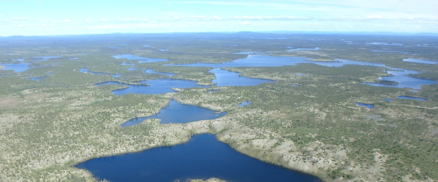
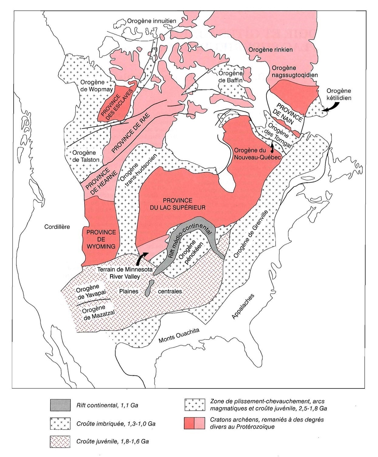 The Superior Province is the core of the Canadian Shield and North America. Being the largest archean terrestrial craton, it covers an area of approximately 1 400 000 km2 of which more than 740 000 km2 are in Quebec (Hocq, 1994). Its north, west and southeast boundaries (Transhudsonian and Grenvillian orogens) are mainly tectonic, while in the south (Penokean Orogen) and north-east (Northern Quebec Orogen), the Superior Province is unconformably overlain or overthrust by Paleoproterozoic supracrustal sequences (Card and Poulsen, 1998).
Geology
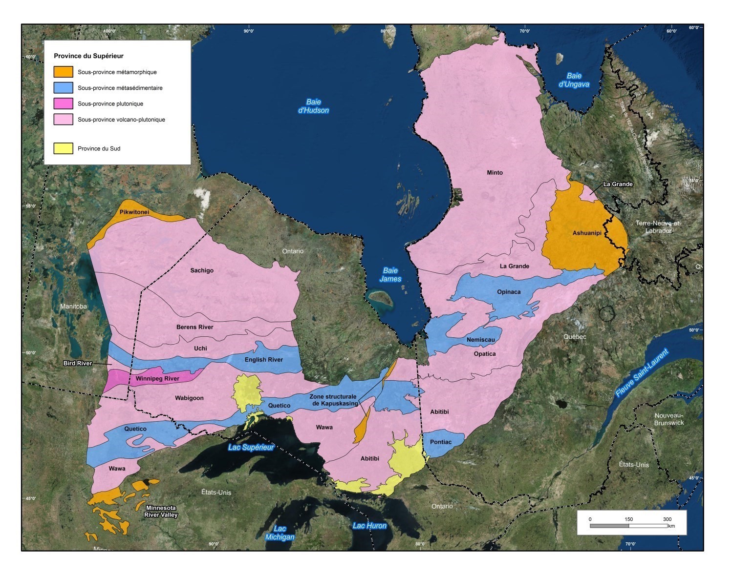
The Superior Province is subdivided into 19 subprovinces, eight of which are observed in Quebec. Four types of subprovinces are recognized: metasedimentary, metamorphic, volcano-plutonic and plutonic.
In Quebec, the Superior Province can be divided into two major zones. The southern zone is characterized by an alternation of linear subprovinces of metasedimentary (Pontiac, Nemiscau and Opinaca), volcano-plutonic (Abitibi, Opatica and La Grande) and metamorphic (Ashuanipi) composition, and characterized by a regional structural grain oriented E-W. The northern zone, which is almost entirely plutonic, corresponds to the Minto Subprovince and includes various geological domains generally oriented NNW-SSE. These domains contain large units of charnockitic rocks and show a steep magnetic relief (Simard et al., 2008). Data collected in the northeastern part of the Superior Province have highlighted two large terranes that define the evolution of the Archean crust. The Hudson Bay Terrane, in the south and west, shows evidence of an Eoarchean crust (> 3600 Ma) and includes some of the oldest rocks on Earth. The history of the Arnaud River Terrane, in the north, began after 2900 Ma in the Mesoarchean (Simard et al., 2008). The origin of the regional structural grain change in direction between the southern and northern zones remains uncertain. Percival et al. (2006) propose that this change reflects an orocline inflection produced by trans-rotational tectonics, a north-south tectonic regime shift, or a "wedge effect" around a proto-craton during Neoarchean magmatism and deformation.
The Superior Province consists largely of Neoarchean rocks (2.8 to 2.5 Ga). Isotopic studies have identified ancient magmatic events and identified important Mesoarchean and Paleoarchean domains (3.6 to 2.8 Ga; Tomlinson et al., 2004; Boily et al., 2006a and 2006b; Percival et al., 2012). Supracrustal sequences have unconformably overlain Archean rocks, and fractures have resulted in several Neoarchean to Paleoproterozoic mafic dyke swarms (Buchan and Ernst 2004; Simard et al., 2008).
Geological Evolution
 The understanding of the Superior Province geological evolution has greatly evolved over the last few years thanks to geological mapping, high precision geochronology and LITHOPROBE program seismic surveys. Recently, Percival et al. (2012) published a synthesis of the geological and tectonic evolution of the Superior Province in which they present the boundaries of the various terranes composing it. The Superior Province would be the result of collisional and accretionary events occurring between 2720 and 2680 Ma involving some proto-continental terranes showing traces of an evolution older than 2.8 Ga, and then cratonization between 2680 and 2600 Ma.
References
| Auteur(s) | Titre | Année de publication | Hyperlien (EXAMINE ou Autre) |
|---|---|---|---|
| BOILY, M. – LECLAIR, A. – MAURICE, C. – BERCLAZ, A. – DAVID, J. | Étude géochimique et isotopique du Nd des assemblages volcaniques et plutoniques du nord-est de la Province du Supérieur (NEPS). Ministère des Ressources naturelles et de la Faune, Québec; MB 2006-03, 50 pages. | 2006a | MB 2006-03 |
| BOILY, M. – LECLAIR, A. – BERCLAZ, A. – LABBÉ, J.-Y. – LACOSTE, P. – SIMARD, M. – MAURICE, C. | Terrane definition in the northeastern Superior Province. Geological Association of Canada; Abstracts Volume 31, page 16. | 2006b | - |
| BUCHAN, K.L. – ERNST, R.E. | Essaims de dykes de diabase et unités apparentées au Canada et dans les régions avoisinantes. Commission géologique du Canada; carte 2022A, 40 pages, 1 plan. | 2004 | Source |
| CARD, K.D. | A review of the Superior Province of the Canadian Shield, a product of Archean accretion. Precambrian Research; volume 48, pages 99-156. | 1990 | Source |
| CARD, K.D. – CIESIELSKI, A. | Subdivisions of the Superior Province of the Canadian Shield. Geoscience Canada; volume 13, pages 5-13. | 1986 | - |
| CARD, K.D. – POULSEN, K.H. | Geology and mineral deposits of the Superior Province of the Canadian Shield. In: Geology of the Precambrian Superior and Grenville Provinces and Precambrian Fossils in North America (Lucas, S. and St-Onge, M.R., co-ordinators). Geological Survey of Canada; Geology of Canada, numéro 7, pages 15-232. | 1998 | Source |
| DOUGLAS, R.J.W. | The National Atlas of Canada. Canada Surveys and Mapping Branch, Energy Mines and Resources; pages. 25-26, 1 plan. | 1973 | - |
| GILL, J.E. | Natural divisions of the Canadian Shield. Royal Society of Canada Transactions; volume 43, series 111, section IV, pages. 61-69. | 1949 | - |
| GOODWIN, A.M. | Archean crust in the Superior Geotraverse area: Geologic overview. In: Proceedings Archean Geochemistry Conference, 1978 (Smith, I.E.M., and Williams, J.G., editors). University of Toronto Press; page 73-106. | 1978 | - |
| HOCQ, M. | Géologie du Québec. Ministère des Ressources naturelles, Québec; MM 94-01, 166 pages. | 1994 | MM 94-01 |
| HOFFMAN, P.F. | Precambrian geology and tectonic history of North America. In: The Geology of North America – An overview (Bally A.W. and Palmer, A.R., editors). Geological Society of America; The Geology of North America, volume A, pages 447-512. | 1989 | - |
| PERCIVAL, J.A. – SANBORN-BARRIE, M. – SKULSKI, T. – WHALEN, J. – WHITE, D. – STOTT, G. – LECLAIR, A. – CORKERY, T. | New insights from Earth's largest craton stimulate Superior research opportunities. GAC-MAC; Program with Abstracts, volume 31, pages 118. | 2006 | - |
| PERCIVAL, J. A. – SKULSKI, T. – SANBORN-BARRIE, M. – STOTT, G.M. – LECLAIR, A.D. – CORKERY, M.T. – BOILY, M. | Geology and tectonic evolution of the Superior Province, Canada. In: Tectonic Styles in Canada: The Lithoprobe Perspective (Percival, J.A., Cook, F.A, and Clowes R.M., editors). Geological Association of Canada; Special Paper 49, pages 321-378. | 2012 | - |
| SIMARD, M. – LABBÉ, J.-Y. – MAURICE, C. – LACOSTE, P. –, LECLERC, A. – BOILY, M. | Synthèse du nord-est de la Province du Supérieur. Ministère des Ressources naturelles et de la Faune, Québec; MB 2008-02, 196 pages, 8 plans. | 2008 | MM 2008-02 |
| STOCKWELL, C.H. | Proposals for time classification and correlation of precambrian rocks and events in Canada and adjacent areas of the Canadian Shield. Part 1: A time classification of precambrian rocks and events. Geological Survey of Canada; Paper 80-19, 135 pages, 6 plans. | 1982 | Source |
| STOCKWELL, C.H. | Age determinations and geological studies. Part II: Geological studies; Fourth Report on Structural Provinces, Orogenies, and Time-Classification of Rocks of the Canadian Precambrian Shield. Geological Survey of Canada; Paper 64-17, 35 pages, 2 plans. | 1964 | Source |
| TOMLINSON, K.Y. – STOTT, G.M. – PERCIVAL, J.A. – SONE, D. | Basement terrane correlations and crustal recycling in the western Superior province; Nd isotopic character of granitoid and felsic volcanic rocks in the Wabigoon subprovince, N. Ontario, Canada. Precambrian Research; volume 132, pages 245-274. | 2004 | Source |
| WILSON, M.E. | The Canadian Shield. In: Geologie der Erde: Geology of North America, Volume 1, ( Ruedemann, R. and Balk, R”, editors). Verlag von Gebrüder Borntraeger, pages 232-311. | 1939 | - |
| WILSON, J.T. | The origin of continents and Precambrian history. Royal Society of Canada Transactions; volume 43, section IV, pages 157-184. | 1949 | - |