


First published: 14 February 2020
Last modified:
DISCLAIMER: This English version is translated from the original French. In case of any discrepancy, the French version shall prevail.
| Author(s): | Parent et al., 2002 |
| Age: | Neoarchean |
| Stratotype: | The type locality is located 10 km north of Qullinaaraaluk Lake (outcrop 2000-JD-2236, where the Qullinaaraaluk Ni-Cu-Co mineralized zone was discovered) |
| Type area: | Vernon Lake area (NTS sheet 34J) |
| Geological province: | Superior Province |
| Geological subdivision: | Minto Subprovince |
| Lithology: | Ultramafic to mafic intrusive rocks |
| Category: | Lithodemic |
| Rank: | Suite |
| Status: | Formal |
| Use: | Active |
None
Background
The Qullinaaraaluk Suite was introduced in the Vernon Lake area (sheet 34J; Parent et al., 2002, 2003) to describe small, massive mafic and ultramafic intrusions considered late, and thus highlight their economic importance following the discovery of Ni-Cu-Co mineralization in a massive ultramafic intrusion (Qullinaaraaluk mineralized zone; Labbé et al., 2000; Baker and Constantin, 2003; Labbé, 2005). The unit name refers to this mineralized zone north of Qullinaaraaluk Lake (sheet 34G10). To the east, these rocks were assigned to the Bacqueville Suite (Parent et al., 2000, 2001; Leclair et al., 2001, 2002). Work in the Vernon Lake area resulted in the decoupling of late mafic and ultramafic rocks from those in the Bacqueville Suite (Parent et al., 2002, 2003). The Qullinaaraaluk Suite was later recognized in the Innuksuac River (sheet 34K; Simard et al., 2003, 2004a), Minto Lake (sheet 34G; Simard et al., 2005a), Eau Claire Lake (sheets 34B and 34C; Simard et al., 2004b, 2005b) and Montrochand Lake (sheet 33O; Roy et al., 2004, 2006) areas (Simard, 2008). Simard et al. (2008) assigned it a series of mafic and ultramafic intrusions that were once part of the Qilalugalik Suite (abandoned unit), in the Kogaluk Bay (sheet 34N; Maurice et al., 2005b) and Puvirnituq (sheet 35C; Maurice et al., 2004, 2005a) areas, based on their resemblance to intrusions of the Qullinaaraaluk Suite.
Description
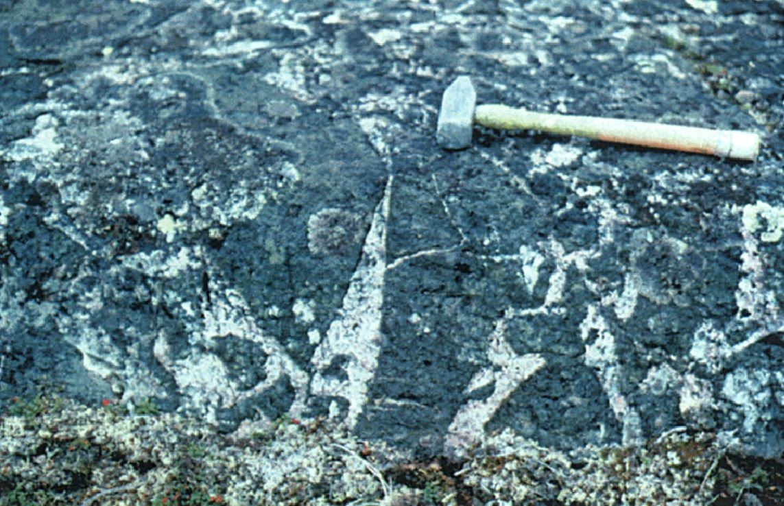
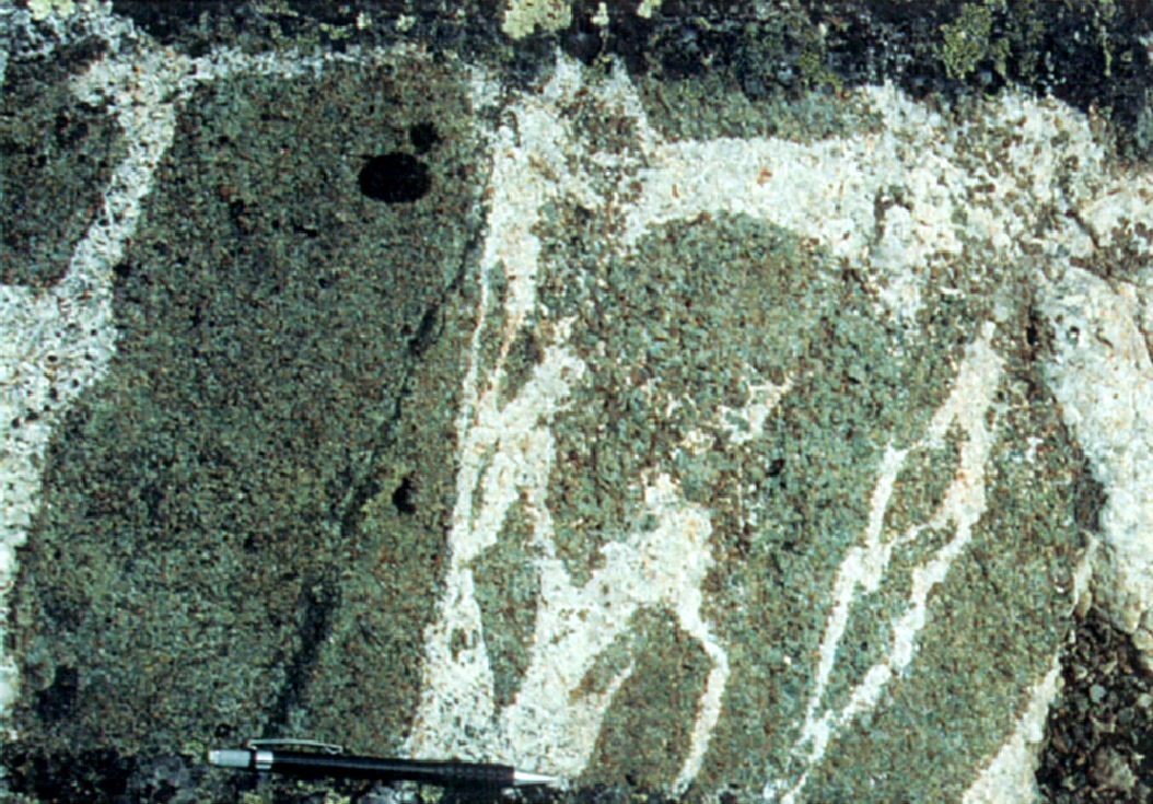
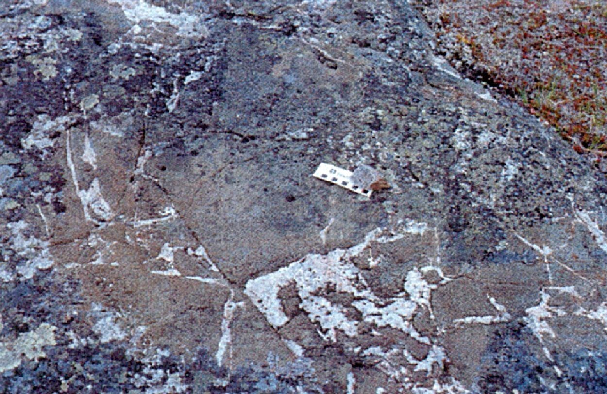
The Qullinaaraaluk Suite consists of small intrusions (usually <1 km in diameter) of ultramafic to mafic composition (Parent et al., 2002, 2003; Simard et al., 2003, 2004a; Simard et al., 2004b, 2005b; Roy et al., 2004, 2006; Maurice et al., 2004, 2005a, 2005b; Simard et al., 2005a; Boily et al., 2006; Simard et al., 2008; Simard, 2008; MNRF 2008, 2010a-h). Rocks are homogeneous, massive, fine to medium grained, and commonly cut by centimetre to decimetre-thick whitish tonalitic to granitic injections, giving them a brecciated appearance. They regularly contain hornblende poikilitic phenocrystals (5-25%, 1-4 cm), resulting in their spotted appearance in outcrop. Rocks of the Qullinaaraaluk Suite usually have a partial granoblastic texture superimposed on a primary igneous texture that indicates a beginning of recrystallization.
In the Innuksuac River and Eau Claire and Minto lakes areas, the Qullinaaraaluk Suite was divided into two units to distinguish mafic facies from those consisting mostly of ultramafic rocks (Simard et al., 2003; Simard et al., 2004; Simard et al., 2005). The first unit consists mainly of ultramafic intrusions (nAluk1) that are generally associated with some mafic intrusions. The second unit consists exclusively of mafic intrusions (nAluk2) similar to those of unit nAluk1.
Qullinaaraaluk Suite 1 (nAluk1): Ultramafic Intrusive Rocks
Ultramafic intrusions consist of pyroxenite, hornblendite and locally peridotite. Rocks are dark green or blackish grey, and their alterated surface is brownish grey to dark brown. They are homogeneous, massive and fine to coarse grained. Primary textures are well preserved and cumulative textures are common.
In thin sections, pyroxenite is composed of pyroxenes (50-85%), green hornblende (10-40%) and interstitial plagioclase (<5%). Clinopyroxene and orthopyroxene are in varying proportions, but clinopyroxene is predominant. Orthopyroxene is fresh or slightly altered to serpentine and talc. Clinopyroxene is partially or completely replaced by green hornblende and more rarely by another, lighter fibrous amphibole, probably of the tremolite-actinolite family. Hornblende also occurs as anhedral grains between pyroxene grains, or as centimetric poikilitic crystals containing clinopyroxene and orthopyroxene inclusions. The rock contains a few reddish biotite or phlogopite flakes. Magnetite generally represents up to 1% of the rock, but can reach 5% in samples containing olivine.
Hornblendite is heterogranular and contains mainly green hornblende; some poikilitic crystals are centimetre sized. It also contains clinopyroxene (<10%) partially replaced by green hornblende, some brown biotite (<5%) partially to highly chloritized, and a small amount of interstitial plagioclase (<5%). Orthopyroxene, highly to completely altered to talc, serpentine, carbonate, chlorite and magnetite is observed locally. Magnetite and pyrite are the main accessory minerals. Zircon is found in minor amounts.
Peridotite contains >40% olive crystals in a predominantly clinopyroxene matrix. Some magnetite is usually associated with olivine. Olivine occurs as subrounded grains and inclusions in pyroxense. It is generally well preserved, locally fractured and very slightly altered to iddingsite.
Overall, ultramafic rocks of the Qullinaaraaluk Suite define two large petrogeochemical complexes (pyroxene-hornblende peridotite and hornblende pyroxenite) in geochemical continuity (Chevé, 2005). However, subtle variations in rare earth fractionation [(La/Yb)NC ratio], Eu/Eu* ratios and chondrite-normalized spider profiles define two groups (Chevé, 2005; Boily et al., 2006).
Unit Aluk1 also includes massive gabbro and gabbronorite similar in appearance to those of unit nAluk2, in sharp or gradual contact with ultramafic rocks, such that some of these plutons could represent mafic to ultramafic differentiated intrusions.
Ultramafic (and mafic) rocks of unit nAluk1 are particularly interesting because they contain some Ni-Cu-EGP ± Co mineralized zones that were discovered following the discovery of the Qullinaaraaluk zone (Labbé et al., 2000; Baker and Constantin, 2003; Labbé, 2005), in particular the Tan, MP-1008, Flipper and Ni-dance mineralized zones. Magmatic mineralization occurs as massive, semi-massive and disseminated sulphides associated with an ultramafic intrusion.
Qullinaaraaluk Suite 2 (nAluk2): Mafic Intrusive Rocks
Mafic intrusions consist of leucocratic to melanocratic gabbro and gabbronorite, medium to coarse-grained and massive in appearance. The rock is greenish grey to blackish grey, locally bluish, with a brownish grey, greenish grey or whitish grey altered surface.
The petrographic study showed a varied composition for mafic intrusions, despite apparent homogeneity in outcrop. Gabbro is composed of sericitized plagioclase (30-70%) and various ferromagnesian mineralogical assemblages: hornblende-biotite, hornblende-biotite-clinopyroxene, hornblende-biotite-clinopyroxene-orthopyroxene and clinopyroxene-orthopyroxene-biotite. Biotite is reddish and minimally altered. Orthopyroxene is partially to highly altered to talc, serpentine, carbonate and chlorite, while clinopyroxene is partially to completely replaced by green hornblende. The magnetite content is variable (up to 3%).
Gabbronorite is composed of plagioclase (40-60%), orthopyroxene (15-20%), clinopyroxene (15-30%) and green hornblende (5-30%). Ferromagnesian minerals are similar to those found in ultramafic rocks and are generally concentrated in clusters. In between, there are agglomerations of euhedral to subhedral unaltered plagioclase grains. Biotite and magnetite occur in minor amounts. A gabbronorite sample cut by a late fault displays complete plagioclase saussuritization and complete clinopyroxene uralitization. The petrographic heterogeneity of mafic rocks indicates that the Qullinaaraaluk Suite may contain mafic intrusions from different magmatic events. This is supported by geochemical differences (Chevé, 2005) and geochronological differences (David, 2012) observed in rocks of this suite.
From a geochemical perspective, mafic rocks have typical geochemical characteristics associated with Neoarchean gabbroic plutons of the Superior Province (Minto Subprovince) (Boily et al., 2006). The geochemistry of major elements indicates affiliation to a magmatic series of tholeiitic affinity (Chevé, 2005; Boily et al., 2006). However, not all gabbros exhibit the same characteristics when minor and trace elements are considered (Chevé, 2005). According to Boily et al. (2006), although it is unlikely that all gabbros-gabbronorites are cogenetic, variations in the Zr/Y ratio and Mg number (Mg#) indicate a general evolution controlled by a “gabbroic fractionation” mechanism.
Thickness and distribution
The Qullinaaraaluk Suite consists of small intrusions generally <1 km in diameter and covering nine sheets (33O, 34B, 34C, 34F, 34G, 34J, 34K, 34N and 35C) in the NW Minto Subprovince. These intrusions tend to be a little larger and more concentrated in the sheets located in the NW (34K and 34N).
Dating
U-Pb dating on zircon of a gabbro sample (nAluk1) from the Flipper mineralized zone, in the Eau Claire Lake area (Simard et al., 2005), yielded a crystallization age of 2705 ±1 Ma. In addition, U-Pb dating on zircon conducted on a leucogabbro sample (nAluk1) from the Tan mineralized zone, in the Minto Lake area (Simard et al., 2004), gave a similar first age of 2706 ±1 Ma and a second older age at 2721 ±2 Ma (David, 2012).
U-Pb dating on zircon of a pegmatite sample cutting the ultramafic intrusion containing the Qullinaaraaluk mineralization, in the Minto Lake area (Simard et al., 2005) yielded an age of 2720 ±2 Ma (David, 2012). This age indicates that the mineralized ultramafic intrusion is older than 2720 Ma. This also indicates that the Qullinaaraaluk Suite groups intrusions of various ages (Simard, 2008).
| Unit | Sample Number | Isotopic System | Mineral | Crystallization Age (Ma) | (+) | (-) | Inherited Age (Ma) | (+) | (-) | Reference(s) |
| nAluk1 | 02-indice-tan-60b | U-Pb | Zircon | 2706 | 1 | 1 | 2721 | 2 | 2 | David, 2012 |
| 02-MS-052A | U-Pb | Zircon | 2705 | 1 | 1 |
Stratigraphic Relationship(s)
Parent et al. (2002, 2004) considered intrusions of the Qullinaaraaluk Suite to be post-tectonic, based on their massive and undeformed appearance. Field observations suggested that the intrusion of the Qullinaaraaluk mineralized zone was at an angle with respect to the structural grain (Labbé et al., 2000) and cut diatexite of the Le Roy Complex (2698 Ma; 2713 Ma, Baker and Constantin, 2003). However, dating on a pegmatite cutting the intrusion yielded an age of 2720 Ma (David, 2012), demonstrating that this intrusion is older than diatexites and that relationships with host rocks are more complex than those initially observed (Simard, 2008). Younger ages of 2705 Ma and 2706 Ma obtained in the Flipper and Tan mineralized zones, respectively, suggest that intrusions of the Qullinaaraaluk Suite may belong to several magmatic events (Simard, 2008).
Similar intrusions to the Qullinaaraaluk Suite were assigned to the Bacqueville Suite to the east in the Nedlouc Lake (Parent et al., 2000, 2001) and La Potherie Lake (Leclair et al., 2001, 2002) areas. It is also possible that intrusions equivalent to those of the Qullinaaraaluk Suite were assigned to the Châteauguay Suite in the Loups Marins Lake (Gosselin et al., 2001, 2002b), Maricourt Lake (Simard et al., 2000, 2002, ) and Bienville Lake (Gosselin et al., 2002a, 2004) areas.
Paleontology
Does not apply.
References
Publications Available Through SIGÉOM Examine
BAKER, M., CONSTANTIN, M. 2003. Pétrologie et métallogénie de l’indice de Ni-Cu-Co de Qullinaaraaluk et d’intrusions mafiques-ultramafiques du domaine du Lac Minto, Sous-province de Minto, Québec. In LECLAIR, A. PROJET DE CARTOGRAPHIE DU GRAND-NORD – RAPPORT D’ATELIER. MRN. MB 2003-01, 91 pages.
BOILY, M., LECLAIR, A., MAURICE, C., BERCLAZ, A., DAVID, J. 2006. ETUDE GEOCHIMIQUE ET ISOTOPIQUE DU ND DES ASSEMBLAGES VOLCANIQUES ET PLUTONIQUES DU NORD-EST DE LA PROVINCE DU SUPERIEUR (NEPS). MINISTERE DES RESSOURCES NATURELLES ET DE LA FAUNE, GEON. MB 2006-03, 50 pages.
CHEVE, S. 2005. LITHOGEOCHIMIE DE LA REGION DU LAC MINTO (34F ET 34G). MRNF. MB 2005-01, 26 pages.
DAVID, J. 2012. Datations isotopiques effectuées dans le nord-est de la Province du Supérieur (Travaux de 2001, 2002 et 2003). MRNF. DV 2012-05, 84 pages.
GOSSELIN, C., ROY, P., DAVID, J. 2002a. GEOLOGIE DE LA REGION DU LAC BIENVILLE (33P). MRN. RG 2002-11, 40 pages and 1 plan.
GOSSELIN, C., ROY, P., DAVID, J. 2004. GEOLOGY OF THE LAC BIENVILLE AREA (33P). MRNFP. RG 2003-04, 36 pages and 1 plan.
GOSSELIN, C., SIMARD, M., DAVID, J. 2001. GEOLOGIE DE LA REGION DES LACS DES LOUPS MARINS (34A). MRN. RG 2001-10, 44 pages and 1 plan.
GOSSELIN, C., SIMARD, M., DAVID, J. 2002b. GEOLOGY OF THE LACS DES LOUPS MARINS AREA (34A). MRN. RG 2002-06, 40 pages and 1 plan.
LABBE, J Y. 2005. LES ELEMENTS DU GROUPE DU PLATINE DANS LA PARTIE NORD-EST DE LA PROVINCE DU SUPERIEUR. MRNF. ET 2004-03, 35 pages.
LABBE, J Y., LACOSTE, P., LECLAIR, A., PARENT, M., DAVY, J. 2000. L’INDICE DE NI-CU-CO DE QULLINAARAALUK : UN NOUVEAU TYPE DE MINERALISATION DANS LES ROCHES ARCHEENNES DU GRAND NORD. MRN. PRO 2000-11, 12 pages.
LECLAIR, A., PARENT, M., DAVID, J., SHARMA, K N M., DION, D J. 2001. GEOLOGIE DE LA REGION DU LAC LA POTHERIE (34I). MRN. RG 2000-12, 50 pages and 1 plan.
LECLAIR, A., PARENT, M., DAVID, J., SHARMA, K N M., DION, D J. 2002. GEOLOGY OF THE LAC LA POTHERIE AREA. MRN. RG 2001-04, 43 pages and 1 plan.
MAURICE, C., BERCLAZ, A., DAVID, J., SHARMA, K N M., LACOSTE, P. 2004. GEOLOGIE DE LA REGION DE POVUNGNITUK (35C) ET DE KOVIK BAY (35F). MRNFP. RG 2003-06, 44 pages and 2 plans.
MAURICE, C., BERCLAZ, A., DAVID, J., SHARMA, K N M., LACOSTE, P. 2005a. GEOLOGY OF THE POVUNGNITUK (35C) AND KOVIC BAY (35F) AREAS. MRNF. RG 2004-05, 41 pages and 2 plans.
MAURICE, C., LACOSTE, P., BERCLAZ, A., DAVID, J., SHARMA, K N M. 2005b. GEOLOGIE DE LA REGION DE KOGALUK BAY (34N ET 34M). MRNFP. RG 2004-01, 37 pages and 2 plans.
MRNF 2008. COMPILATION GÉOLOGIQUE 1/250 000 – LAC GUILLAUME-DELISLE. In MRNF. 2010. CARTE(S) GÉOLOGIQUE(S) DU SIGEOM – feuillet 34C. CG SIGEOM34C, 2 plans.
MRNF. 2010a. CARTE(S) GÉOLOGIQUE(S) DU SIGEOM – feuillet 33O. CG SIGEOM33O, 1 plan.
MRNF. 2010b. CARTE(S) GÉOLOGIQUE(S) DU SIGEOM – feuillet 34B. CG SIGEOM34B, 1 plan.
MRNF. 2010c. CARTE(S) GÉOLOGIQUE(S) DU SIGEOM – feuillet 34F. CG SIGEOM34F, 1 plan.
MRNF. 2010d. CARTE(S) GÉOLOGIQUE(S) DU SIGEOM – feuillet 34G. CG SIGEOM34G, 1 plan.
MRNF. 2010e. CARTE(S) GÉOLOGIQUE(S) DU SIGEOM – feuillet 34J. CG SIGEOM34J, 1 plan.
MRNF. 2010f. CARTE(S) GÉOLOGIQUE(S) DU SIGEOM – feuillet 34K. CG SIGEOM34K, 1 plan.
MRNF. 2010g. CARTE(S) GÉOLOGIQUE(S) DU SIGEOM – feuillet 34N. CG SIGEOM34N, 1 plan.
MRNF. 2010.h CARTE(S) GÉOLOGIQUE(S) DU SIGEOM – feuillet 35C. CG SIGEOM35C, 1 plan.
NANTEL, S., GIROUX, F. 2005. GEOLOGIE DE LA REGION DU LAC PINE, PARTIE SUD (31O/02). MRNFP. RG 2004-03, 31 pages and 1 plan.
PARENT, M., LECLAIR, A., DAVID, J., SHARMA, K N M., LACOSTE, P. 2002. GEOLOGIE DE LA REGION DU LAC VERNON (34J). MRN. RG 2001-11, 44 pages and 1 plan.
PARENT, M., LECLAIR, A., DAVID, J., SHARMA, K N M., LACOSTE, P. 2003. GEOLOGY OF THE LAC VERNON AREA (34J). MRN. RG 2002-07, 40 pages and 1 plan.
ROY, P., TURCOTTE, S., SHARMA, K N M., DAVID, J. 2004. GEOLOGIE DE LA REGION DU LAC MONTROCHAND (33O). MRNFP. RG 2003-10, 41 pages and 1 plan.
ROY, P., TURCOTTE, S., SHARMA, K N M., DAVID, J. 2006. GEOLOGY OF THE LAC MONTROCHAND AREA (33O). MRNF. RG 2005-04, 42 pages and 1 plan.
SIMARD, M. 2008. LEXIQUE STRATIGRAPHIQUE DES UNITES ARCHEENNES DU NORD-EST DE LA PROVINCE DU SUPERIEUR. MRNF. DV 2008-03, 107 pages.
SIMARD, M., CHEVE, S., DAVID, J., LABBE, J Y., SHARMA, K N M. 2005a. GEOLOGIE DE LA REGION DU LAC MINTO (34F ET 34G). MRNFP. RG 2004-04, 27 pages and 2 plans.
SIMARD, M., GOSSELIN, C., DAVID, J. 2000. GEOLOGIE DE LA REGION DE MARICOURT (SNRC 24D). MRN. RG 2000-07, 52 pages and 1 plan.
SIMARD, M., GOSSELIN, C., DAVID, J. 2002. GEOLOGY OF THE MARICOURT AREA. MRN. RG 2001-07, 44 pages and 1 plan.
SIMARD, M., LABBE, J Y., MAURICE, C., LACOSTE, P., LECLAIR, A., BOILY, M. 2008. SYNTHESE DU NORD-EST DE LA PROVINCE DU SUPERIEUR. MRNF. MM 2008-02, 198 pages and 8 plans.
SIMARD, M., PARENT, M., DAVID, J., SHARMA, K N M. 2003. GEOLOGIE DE LA REGION DE LA RIVIERE INNUKSUAC (34K ET 34L). MRN. RG 2002-10, 45 pages and 2 plans.
SIMARD, M., PARENT, M., DAVID, J., SHARMA, K N M. 2004a. GEOLOGY OF THE RIVIERE INNUKSUAC AREA (34K AND 34L). MRNFP. RG 2003-03, 42 pages and 2 plans.
SIMARD, M., PARENT, M., THERIAULT, R., DAVID, J., LACOSTE, P., SHARMA, K N M. 2004b. GEOLOGIE DE LA REGION DU LAC A L’EAU CLAIRE (34B ET 34C). MRNFP. RG 2003-08, 48 pages and 2 plans.
SIMARD, M., PARENT, M., THERIAULT, R., DAVID, J., LACOSTE, P., SHARMA, K N M. 2005b. GEOLOGY OF THE LAC A L’EAU CLAIRE AREA (34B AND 34C). MRNF. RG 2004-06, 47 pages and 2 plans.
Suggested Citation
Ministère de l’Énergie et des Ressources naturelles (MERN). Qullinaaraaluk Suite. Quebec Stratigraphic Lexicon. https://gq.mines.gouv.qc.ca/lexique-stratigraphique/province-du-superieur/suite-de-qullinaaraaluk_en [accessed on Day Month Year].
Collaborateurs
|
First Publication |
Céline Dupuis, P. Geo., Ph.D. celine.dupuis@mern.gouv.qc.ca (redactrion, French and English versions) Mehdi A. Guemache, P. Geo., Ph.D. (coordination); anonymous (critical review); Simon Auclair, P. Geo., M.Sc. (editing); Nathalie Bouchard (HTML editing). |