

Last modified:
Translation of original French
| Author: | Madore et al., 1999 |
| Age: | Neoarchean |
| Reference section: | |
| Type area: | Peters Lake area (NTS sheet 24M) |
| Geological province: | Superior Province |
| Geological subdivision: | Minto Subprovince / Rivière Arnaud Terrane / Douglas-Harbour Domain |
| Lithology: | Tonalite and trondhjemite |
| Type: | Lithodemic |
| Rank: | Suite |
| Status: | Formal |
| Use: | Active |
None
Background
The Faribault-Thury Complex was introduced in the Peters Lake area (NTS sheet 24M) to group all tonalitic units, metamorphosed volcano-sedimentary rock klippes (mAarn) and some granitic intrusions (nAlrd) (Madore et al., 1999). It has been extended in the Arnaud River (sheet 25D), Klotz Lake (sheet 35A), Pélican Lake (sheet 34P) and Dufreboy Lake (sheet 24L) areas (Madore and Larbi, 2000; Madore et al., 2001; Cadieux et al., 2002; Leclair et al., 2003). The Faribault-Thury Complex subunits were then reassigned to new formal units (Simard et al., 2008). The tonalitic units (Afth4 and Afth4a) were assigned to the Faribault-Thury Suite (nAfth), the volcano-sedimentary rocks of the Arnaud Complex (mAarn) and granitic intrusions to the Leridon Suite (nAlrd).
| Revised Unit | Previous Subunit | Reference(s) of Previous Subunits |
| nAfth1 | Afth4 | Madore et al., 1999 et 2001; Madore and Larbi, 2000; Cadieux et al., 2002 |
| Afth4b | Cadieux et al., 2002 | |
| nAfth1a | Afth4a | Madore and Larbi, 2000; Madore et al., 2001 |
| Abte | St-Onge and Lucas, 1997a et b | |
| nAfth1b | Afth4 | Madore et al., 1999 |
| Afth4a | Cadieux et al., 2002 |
Description
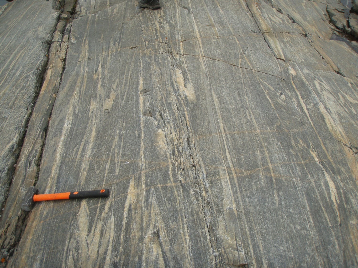
Faribault-Thury Suite 1 (nAfth1): Gneissic or Foliated Tonalite
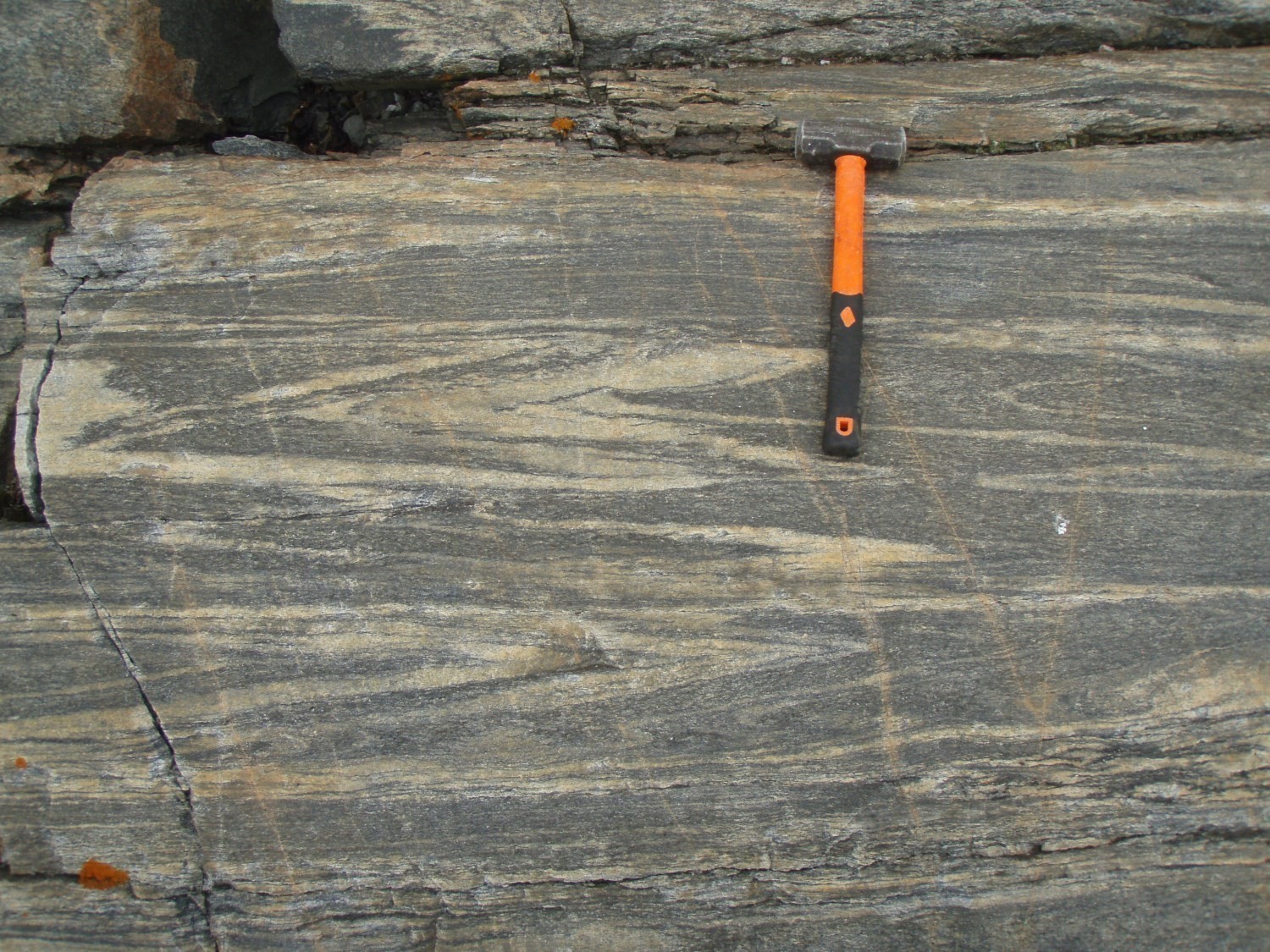
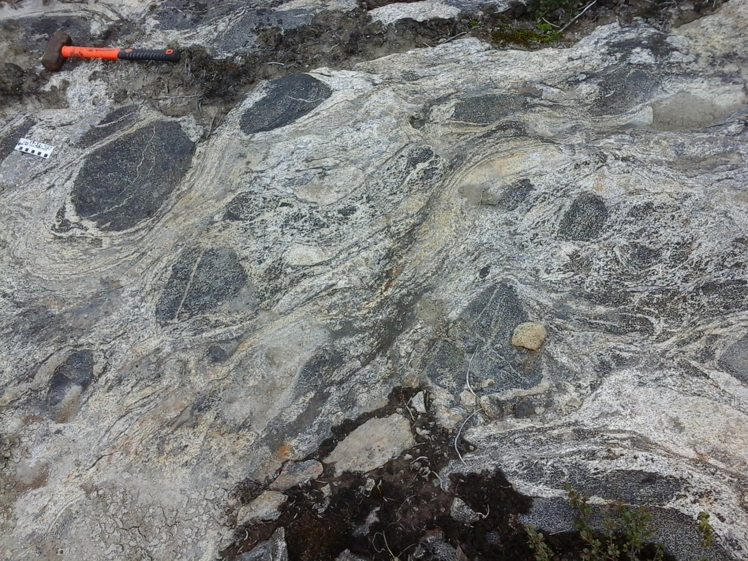
The Faribault-Thury Suite corresponds to an Archean suite of the “TTG” type (Madore et al., 1999; Ridley and Kramers,1990; Martin, 1994; Rudnick, 1995; Berger and Rollinson, 1997). It consists mainly of foliated to gneissic tonalite and, in smaller proportions, of trondhjemite, diorite and granodiorite (nAfth1). A large proportion of these rocks have undergone migmatisation at varying degrees of partial melting, which is evidenced by the presence of 5 to 50% tondhjemitic to granitic mobilisate. This mobilisate is in the form of centimetric to decametric discontinuous bands (or horizons), parallel or secant to regional foliation. Decimetric to decametric enclaves of intrusive rocks (ranging from gabbro to tonalite) and supracrustal rocks (amphibolite and paragneiss of the Arnaud Complex) account for 1 to 25% of outcropping surfaces.
Rocks are composed of quartz and plagioclase, in relatively equal proportions, and fewer than 10% of interstitial K-feldspar. The grain size is generally fine to medium and usually granoblastic. Minerals marking foliation usually have a lepidoblastic texture (biotite), more locally nematoblastic (amphibole), and quartz is often found in polycristalline millimetric ribbons. Tonalite contains 10 to 40% ferromagnesian minerals mainly represented by biotite and hornblende. Accessory minerals are garnet, muscovite, epidote, magnetite, ilmenite, zircon, sphene, apatite and allanite. Plagioclase is often sericitized and contains secondary epidote and calcite inclusions.
Faribault-Thury Suite 1a (nAfth1a): Gneissic Tonalite with Mafic Enclaves
This tonalite is petrographically similar to that of the nAfth1 unit, but is distinguished by the abundance of mafic and ultramafic enclaves (Madore and Larbi, 2000; Madore et al., 2001; St-Onge and Lucas, 1997a, 1997b).
Faribault-Thury Suite 1b (nAfth1b): Trondhjemite
Trondhjemite is petrographically similar to tonalite of the nAfth1 unit, but distinguishes itself by its content in ferromagnesic minerals of less than 10%.
Thickness and Distribution
The Faribault-Thury Suite occupies most of the Douglas-Harbour Domain, the northeast segment of the Minto Subprovince. It is located in an area that extends approximately 300 km north-south and 150 km east-west. It is mainly contained in sheets 24M and 25D and, in smaller parts, in sheets 24L, 34P, 35A, 35H, 25E and 25C. Specifically, the gneissic tonalite with mafic enclaves subunit (nAfth1a) is located primarily in the vicinity of the village of Kangiqsujuaq in sheets 35H09 and 25E12. The trondhjemite subunit (nAfth1b) is located primarily in the Douglas Harbour Domain's western portion in sheet 34P.
Dating
Several U-Pb and Pb/Pb datings (David et al., 2009) have attributed an age between 2785 and 2751 Ma to the Faribault-Thury Suite (Simard et al., 2008). Some older U-Pb ages ranging from 2879 to 2857 Ma (David et al., 2009; Percival et al., 2001) were also obtained for tonalites that were originally assigned to the Faribault-Thury Suite. These tonalites are interpreted as remnants of older tonalites (Simard et al., 2008). The crystallization age of the Faribault-Thury Suite is contemporaneous with the Kapijuq and Rochefort tonalitic suites further west. These three units belong to a major tonalitic magmatic episode that affected the northern part of the Minto Subprovince between 2790 and 2760 Ma (Simard et al., 2008).
| Isotopic System | Mineral | Cristallization Age (Ma) | (+) | (-) | Inherited Age (Ma) | (+) | (-) | Metamorphic Age (Ma) | (+) | (-) | Reference(s) |
| Pb/Pb | Zircon | 2751 | 6 | 6 | 2840 | 12 | 12 | 2653 | 14 | 14 | David et al., 2009 (No 166) |
| U-Pb | Zircon | 2785 | 6 | 4 | - | - | - | - | - | - | David et al., 2009 (No 172) |
| Pb/Pb | Zircon | 2778 | 13 | 13 | - | - | - | - | - | - | David et al., 2009 (No 171) |
| Pb/Pb | Zircon | 2810-2740 | - | - | 3020, 2990 and 2892 | - | - | 2732 | 16 | 16 | David et al., 2009 (No 170) |
Stratigraphic Relationship(s)
The Faribault-Thury Suite occupies the Douglas Harbour Domain's western edge. At this location, it is in contact with the Lepelle Domain in the northwest and the Utsalik Domain in the southwest. The nature of contacts is tectonic in a few places, where there are regional faults of undetermined movement separating these domains. At its eastern limit, the Faribault-Thury Suite is also in tectonic contact with the Diana Structural Complex, a unit of tectonically reworked Archean rocks strongly affected by Proterozoic deformation (Madore and Larbi, 2000). Its contact is marked by dextral kinematic deformation corridors.
The Faribault-Thury Suite is also in contact with the volcano-sedimentary Proterozoic sequences of the Labrador Trough in its eastern part and the Ungava Trough in its northern limit. Some parts of the Labrador Trough are bounded by a thrust zone (Madore et al., 2001; Bouchard et al., 1999), while others unconformably lie on Archean units (Bilodeau and Caron-Côté, 2018). The Ungava Trough is in tectonic contact with the Faribault-Thury Suite (Madore et al., 2001; St-Onge et al., 1988; St-Onge and Lucas, 1990c).
The Faribault-Thury Suite is in contact with the Trojan, Qimussinguat and Arnaud complexes, and the Leridon Suite. In some places, it is tectonically separated from the Trojan and Qimussinguat complexes by areas of intense ductile deformation (Madore et al., 1999). Tonalites also contain several kilometre-sized klippes of the Arnaud Complex. Field relationships show that tonalite intrudes these klippes of supracrustal rocks (Bilodeau and Caron-Côté, 2018). Some observations suggest that the Arnaud Complex klippes overthrust the Faribault-Thury Suite (Madore et al., 1999). Tonalites are cut by granitic and monzonitic intrusive rocks of the Leridon Suite (nAlrd) and by two families of Proterozoic dykes, the Klotz Dykes (pPktz) and the Rivière Payne Dykes (pPpay).
Paleontology
Does not apply.
References
| Author(s) | Title | Year of Publication | Hyperlink (EXAMINE or Other) |
|---|---|---|---|
| BILODEAU, C. – CARON-CÔTÉ, E. | Géologie de la région de la rivière Arnaud, provinces du Supérieur (Minto) et de Churchill (Fosse du Labrador), secteur de Kangirsuk, Nunavik, Québec, Canada. Ministère de l'Énergie et des Ressources naturelles, Québec. | 2018 | Bulletin géologiQUE |
| BOUCHARD, N. – GOULET, N. – MADORE, L. | Le chevauchement des roches de la Fosse du Labrador et de ses équivalents stratigraphiques : l’exemple de la séquence supracrustale de la région du lac Nagvaraaluk. Dans : Explorer au Québec : Le défi de la connaissance, Programme et résumés. Ministère des Ressources naturelles, Québec; DV 99-03, page 41. | 1999 | DV 99-03 |
| CADIEUX, A.-M. – BERCLAZ, A. – LABBÉ, J.-Y. – LACOSTE, P. – DAVID, J. – SHARMA, K.N.M. | Géologie de la région du lac Pélican (SNRC 34P). Ministère des Ressources naturelles, Québec; RG 2002-02, 49 pages. | 2002 | RG 2002-02 |
| DAVID, J. – MAURICE, C. – SIMARD, M. | Travaux de géochronologie U-Pb du Programme Grand Nord, partie 1 : cartographie géologique des étés 1998, 1999 et 2000. Ministère des Ressources naturelles et de la Faune, Québec. DV 2008-05, 92 pages | 2009 | DV 2008-05 |
| LECLAIR, A. – BERCLAZ, A. – PARENT, M. – CADIEUX, A.-M. – SHARMA, K.N.M. | Géologie 1/250 000, 24L - LAC DUFREBOY. Ministère des Ressources naturelles, Québec; carte SI-24L-C2G-03C. | 2003 | Carte SI-24L-C2G-03C |
| MADORE, L. – LARBI, Y. | Géologie de la région de la rivière Arnaud (SNRC 25D) et des régions littorales adjacentes (SNRC 25C, 25E et 25F). Ministère des Ressources naturelles, Québec; RG 2000-05, 37 pages. | 2000 | RG 2000-05 |
| MADORE, L. – LARBI, Y. – SHARMA, K.N.M. – LABBÉ, J-Y. – LACOSTE, P. – DAVID, J. – BROUSSEAU, K. – HOCQ, M. | Géologie de la région du lac Klotz (35A) et du Cratère du Nouveau-Québec (1/2 sud de 35H). Ministère des Ressources naturelles, Québec; RG 2001-09, 44 pages. | 2001 | RG 2001-09 |
| MADORE, L. – BANDYAYERA, D. – BÉDARD, J.H. – BROUILLETTE, P. – SHARMA, K.N.M. – BEAUMIER, M. – DAVID, J. | Géologie de la région du lac Peters (SNRC 24M). Ministère des Ressources naturelles, Québec; RG 99-07, 41 pages. | 1999 | RG 99-07 |
| PERCIVAL, J.A. – STERN, R.A. – SKULSKI, T. | Crustal growth through successive arc magmatism: reconnaissance U-Pb SHRIMP data from the northeastern Superior Province. Canada Precambrian Research; Volume 109, p. 203-238. | 2001 | Source |
| SIMARD, M. | Lexique stratigraphique des unités archéennes du nord-est de la Province du Supérieur. Ministère des Ressources naturelles et Faune; DV 2008-03, 107 pages. | 2008 | DV 2008-03 |
| SIMARD, M. – LABBÉ, J-Y. – MAURICE, C. – LACOSTE, P. – LECLAIR, A. – BOILY, M. | Synthèse du nord-est de la Province du Supérieur. Ministère des Ressources naturelles et de la Faune, Québec; MM 2008-02, 196 pages. | 2008 | MM 2008-02 |
| ST-ONGE, M.R. – LUCAS, S.B. | Géologie, Joy Bay, Québec-Territoires du Nord-Ouest; Commission géologique du Canada, Carte série "A" 1916A, 1997a, 2 feuilles. | 1997 | Source |
| ST-ONGE, M.R. – LUCAS, S.B. | Géologie, Pointe Rouge, Québec-Territoires du Nord-Ouest; Commission géologique du Canada, Carte série "A" 1914A, 1997b, 2 feuilles. | 1997 | Source |
| ST-ONGE, M.R. – LUCAS, S.B. | Evolution of the Cape Smith Belt : Early Proterozoic continental underthrusting, ophiolite obduction and thick-skinned folding. IN: The Early Proterozoic Trans-Hudson Orogen: Lithotectonic Correlations and Evolution (J.F. Lewry and M.R. Stauffer, editors). Geological Association of Canada, Special Paper 37; pages 313-351. | 1990 | Source |
| ST-ONGE, M.R. – LUCAS, S.B. – SCOTT, D.J. – BÉGIN, N.J. – HELMSTEADT, H. – CARMICHAEL, D. | Thin-skinned imbrication and subsequent thick-skinned folding of rift-fill, transitionalcrust, and ophiolite suites in the 1.9 Ga Cape Smith Belt, northern Quebec. In: Current Research, Part C, Geological Survey of Canada, Paper 88-1C; pages 1-18. |
1988 |
Source |