

Last modified:
Background
The Minto Subprovince was originally described by Card and Ciesielski (1986) as a gneiss terrain characterized by a high degree of metamorphism. Mapping by the Geological Survey of Canada (Percival and Card, 1994; Percival et al., 1995, 1996, 1997a) and the Ministère with the Programme Grand Nord has shown that its nature is essentially plutonic (Simard et al., 2008). The Minto Subprovince is named after Minto Lake, a large body of water located more than 60 km east of Hudson Bay and the source of the River aux Feuilles.
The first observations of the northeast Superior Province were made by geologists from the Geological Survey of Canada (GSC), including Bell (1877, 1885) and Low (1889, 1898, 1902), during a series of expeditions to the coastal regions of the Ungava Peninsula, and inland via tributary rivers and streams. The geology of the region has also been briefly described on pathways through the lakes and rivers within the peninsula (Flaherty, 1918; Aubert de la Rue, 1948). Other geological observations were reported by Kranck (1951) along the eastern shore of Hudson Bay, as well as by Kretz (1960), who published a 1:1,013,760 scale map of the northern portion of the Ungava Peninsula. It will not be until the 1950s and 1960s that the Geological Survey of Canada began systematic mapping of the entire northeastern Superior Province. Geological helicopter surveys were conducted by Eade (1966) and Stevenson (1968) between the 52nd and 61st parallel north. Two 1:1000,000 scale geological maps were produced and subsequently integrated into the Quebec geological map (Avramtchev, 1985). During the same period, Lee (1965) mapped Archean and Proterozoic rocks (including the Nuvvuagittuq Belt) along the coastal zone, south of the village of Inukjuak, on a mile-to-inch scale. Reconnaissance mapping of the rest of the Ungava Peninsula was completed by Taylor (1982) who produced a map of the area north of the 61st parallel at a scale of 1:250,000. Pennsylvanian rocks on the islands of Lake à l’Eau Claire, associated with meteoritic impact, were mapped by Kranck and Sinclair (1963), Bostock (1969) and Rondot et al. (1993).
During the 1980s and 1990s, the GSC continued its work in the northeastern Superior Province. Card and Ciesielski (1986) were the first to subdivide the region into four major subprovinces: 1) the volcano-plutonic La Grande Subprovince to the south; 2) the plutonic Bienville Subprovince in the centre; 3) the plutonic, high-grade metamorphic Ashuanipi Subprovince to the east; and 4) the plutonic-gneissic Minto Subprovince to the north. Subsequently, the GSC conducted a 1:500,000-scale geological survey along the River aux Feuilles (Percival and Card, 1994), followed by three additional 1:250,000 surveys in more northerly areas (Percival et al., 1995, 1996, 1997). In 1994, Lamothe (1997) mapped the Lac Dupire Volcano-Sedimentary Belt at a scale of 1:50,000. This project was motivated by the presence of high-intensity magnetic lineaments extending several kilometres in the Dupire Lake area.
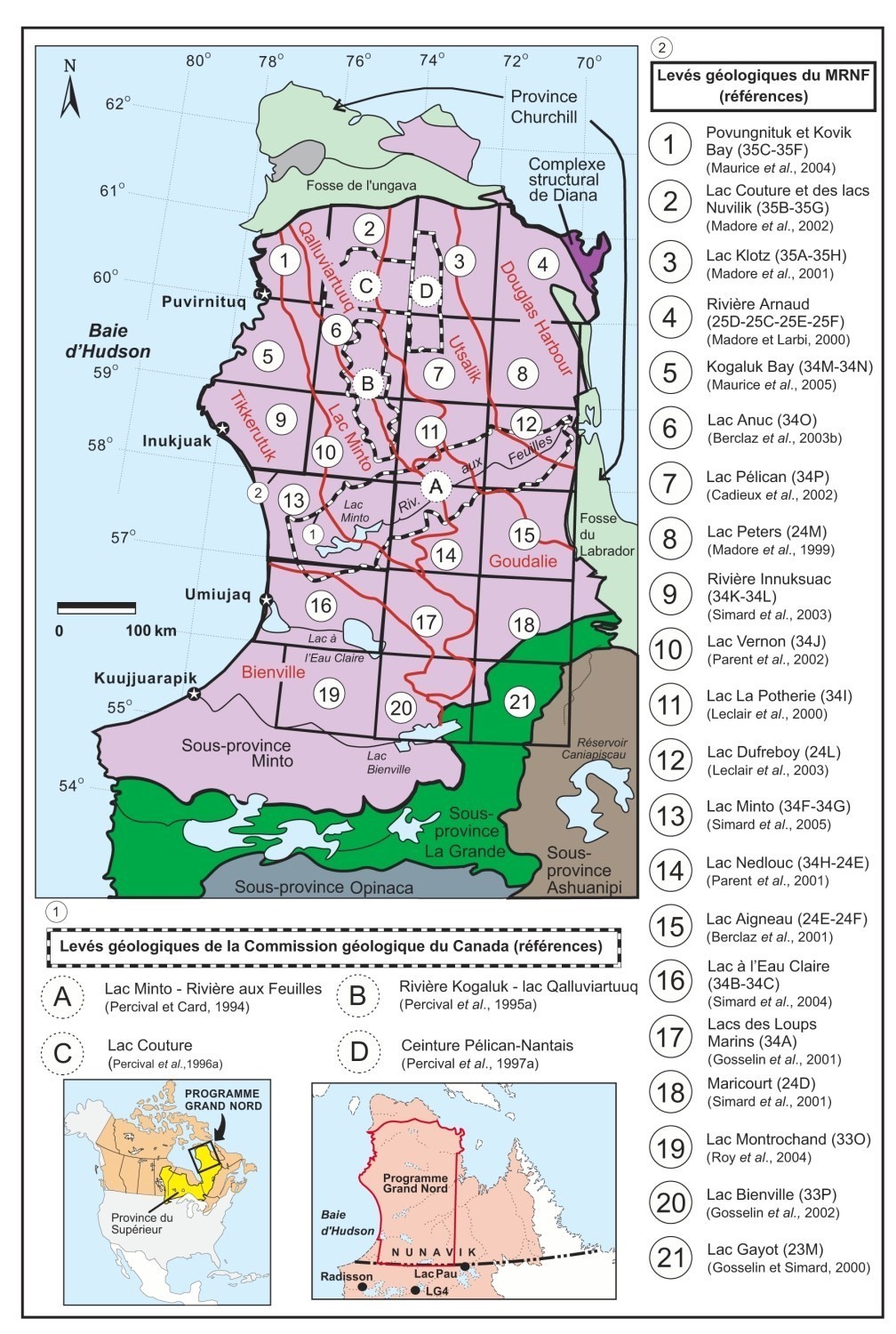
In 1997, the Government of Quebec launched one of the most ambitious geological mapping programs north of the 55th parallel. The Programme Grand Nord was designed to open up new territories for mineral exploration by acquiring new geoscience data in a little-known area of approximately 350,000 km2 within the Nunavik territory. The program began in 1997 with a major geochemical survey of lake bottom sediments funded through a partnership between the Ministère des Resources naturelles and five mining companies (Cambior, Falconbridge, Noranda, SOQUEM and Virginia Mines). The 26,220 samples, taken using a 12 km2 mesh, generated targets that prompted some mining companies to undertake exploration. The Programme Grand Nord continued with an extensive geological mapping campaign that ran from 1998 to 2003. During this period, 21 1:250,000-scale geological surveys were conducted.
The work of the Geological Survey of Canada, conducted in targeted areas of the Minto Subprovince between 1990 and 1997, has helped to redefine its boundaries and subdivide it into several lithotectonic domains based on aeromagnetic, lithological and structural criteria (Percival et al., 1992). The authors also note that the Minto Subprovince appears to be largely composed of more or less deformed plutonic rocks rather than gneissic rocks as proposed by Card and Ciesielski (1986). Subsequently, Ciesielski (1998) changed the boundaries of the Bienville, Minto and Ashuanipi subprovinces based primarily on the sharp contrasts of the magnetic signature. Finally, the Ministère‘s systematic mapping of the northeast Superior Province between 1998 and 2003 allowed for a redefinition of these large lithotectonic packages, confirming the plutonic character of the Minto Subprovince and recongnising the Bienville Subprovince as a domain within the Minto Subprovince (Simard et al., 2008).
In 2009, the Ministère began a new project to complete geological mapping of the southern part of the Bienville Domaine of the Minto Subprovince. Two mapping campaigns were conducted in 2009 and 2010 in the Laforge 1 Reservoir and Kinglet Lake regions (Simard and Lafrance, 2011a, 2011b). To date, only the western part of the Bienville Domain (sheets 33K, 33L and 33N) has not been systematically mapped and geological knowledge is still fragmented. In the summer of 2017, a new geological survey was conducted in the northern Labrador Trough in the Kangirsuk area (Bilodeau and Caron, 2018). This new survey also covered some of the rocks in the Douglas Harbour Domain of the Minto Subprovince.
Description
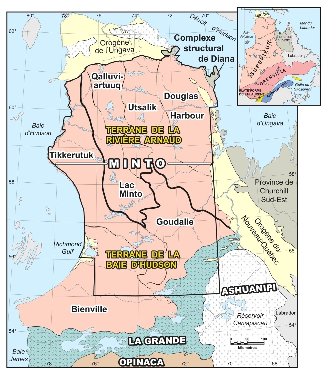
The Minto Subprovince is a subdivision of the Superior Province. It covers its entire northern part, covering a vast area of more than 336,000 km2. It is bordered in part by sedimentary and volcanic rocks of Paleoprotezoic age. Rocks of the Labrador Trough connected to the Orogen of New Quebec are found to the east (Wardle et al., 2002; Clark and Wares, 2004), to the north are rocks of the Ungava Trough associated with the Ungava Orogen (Taylor, 1982; St-Onge and Lucas, 1990; Lamothe, 1994), and rocks associated with the Richmond Gulf Graben are found to the west (Dimroth et al., 1970; Chandler, 1988). To the south, the Minto Subprovince is limited by Archean volcano-plutonic rocks of the La Grande Subprovince.
The definition of contact between the Minto and La Grande subprovinces has been discussed several times over the years, especially on the section of the boundary involving the Goudalie Domain. This part of the boundary between Minto and La Grande was provisionally regarded as a tectonostratigraphic package, the “Goudalie – La Grande Package” by Gosselin and Simard (2000) and Simard et al. (2001). Further west, the boundary between the Bienville Domain and La Grande Subprovince is well defined, intrusive in nature and does not appear to be marked by any major structure (Gosselin et al., 2002; Simard and Lafrance, 2011a, 2011b). The intrusive nature of contact between these two subprovinces has also been recognized in the Carbillet Bay and Pikwahipanan Pass regions (Goutier et al., 2001).
Geology
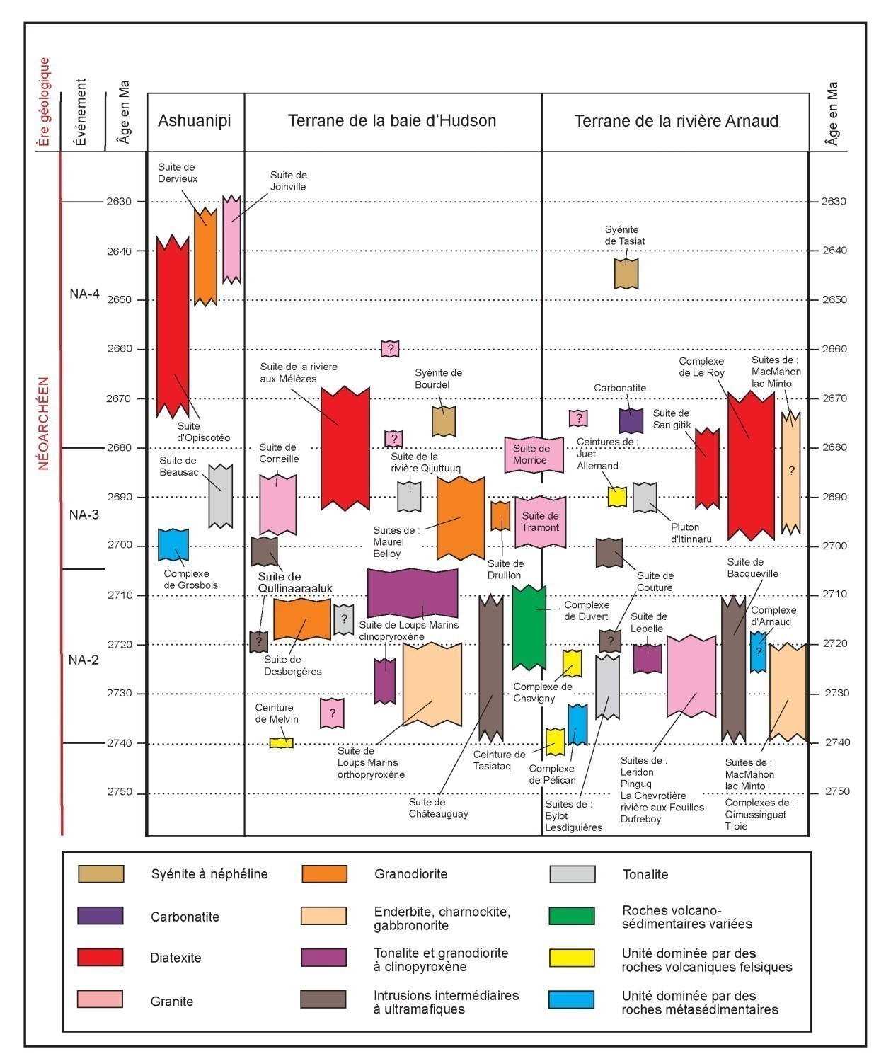
The current geological knowledge of the Minto Subprovince is derived from the entire new data acquired through the Programme Grand Nord. The Minto Subprovince is predominantly composed of Archean plutonic rocks. These igneous rocks, of felsic to ultramafic composition, are more or less foliated and have variably preserved their original textures. Felsic plutonic rocks are the most common and widespread. They are composed of tonalite (40%), granite (20%), granodiorite (15%), charnockitic rocks (15%) and, more rarely, monzonite and syenite (<1%). They usually appear in elongated sheets defining the predominant structural style of the region. Small, limited plutons of dioritic, gabbroic and ultramafic rocks account for less than 2% of the bedrock. Metalvolcanic and metasedimentary rocks account for less than 10% of all Archean rocks. These rocks form isolated lenticular units or discontinuous dismembered belts within the intrusive masses. The best preserved belts can be up to 10 km wide and 120 km long (Leclair, 2008). Geochronological data collected on Archean rocks enabled the development of a stratigraphic model and thus positioning of stratigraphic units in a temporal evolution model for the Archean period between 3830 and 2630 Ma (period before 2740 Ma; period between 2740 and 2630 Ma). In addition, a unified stratigraphy for all Archean units of the northeast Superior Province has been proposed in a stratigraphic lexicon that mainly describes lithodemic units that group intrusive and metamorphic rocks (Simard, 2008).
Paleoproterozoic sedimentary rocks of the Sakami Formation lie unconformably on the rocks of the Minto Subprovince and form small isolated klippes, scattered along a mainly EW axis at the 56th parallel (Eade, 1966; Clark, 1984). In the La Grande Subprovince, cross-cutting relationships involving diabase dykes were used to assess the age of the Sakami Formation between 2500 and 2216 Ma (Goutier et al., 2001). A K-Ar dating obtained from micas contained in a Sakami sandstone (Clark, 1984) indicates a sedimentation age prior to 2230 Ma. There are also a dozen Proterozoic dyke swarms of different orientation cutting Minto Archean rocks (Buchan and Ernst, 2004; Maurice, 2008). These diabase dykes, which are generally less than 100 m thick, can be tracked over several kilometres. They are not deformed or metamorphosed, except in certain areas near the Proterozoic orogens. In addition, a swarm of about 100 lamprophyre and carbonatite dykes occupies the central part of the Aigneau Lake region. Some dykes were also observed in the northeast region of Gayot Lake. They are centimetric to metric dykes with orientation ranging from NW-SE to NS. Carbonatite dykes are spatially associated with carbonate lamprophyre dykes. Carbonatite is a homogeneous rock, fine to coarse-grained, characterized by an orange to rusty-brown colour in altered surface. Dating made on two carbonatite dykes gave ages of 1932 Ma and 1941 Ma (Simard et al., 2008).
Two diatremes were identified along the Ungava Trough in the Couture Lake area. These rocks had been recognized by Moorhead (1989) who included them in the Povungnituk Group (Ungava Orogen). The relationship between the diatremes and the supracrustal sequence of the Povungnituk Group has not been established, Madore et al. (2002) grouped the two intrusions under the term Kuuvvaluk Diatremes. These are small, unbroken circular intrusions of approximately 70 m in diameter, composed of ultramafic phlogopite lamprophyre with pyroxene and olivine relics showing well-preserved igneous textures. These intrusions were not dated, but likely belong to the Proterozoic. Two diatreme breccias were also observed in the Lake à l’Eau Claire area but were not assigned to any stratigraphic units. Field observations suggest that these breccias are associated with the intrusion of Proterozoic diabase dykes in this area. These are 15 to 20 m thick brecciated dykes containing fragments of sedimentary rocks and Proterozoic volcanic glass as well as fragments of Archean granitoids. One of these dykes was interpreted as a clastic sedimentary dyke by Chandler (1988).
Pennsylvanian-aged impactites (Bostock, 1969; Rondot et al., 1993) containing Ordovician limestone enclaves are found on the ring of islands in the centre of Lake à l’Eau Claire. The two rounded depressions at Lake à l’Eau Claire were the result of a double meteoritic impact (Beals et al., 1956, 1960). The impact rocks were dated by K-Ar (Bostock, 1969), Rb-Sr (Reimold et al., 1981) and Ar-Ar (Bottomley et al., 1990) methods. The ages obtained, approximately 280 Ma, indicate that a cover of Pennsylvanian rocks was present at the time of impact. Silurian-aged impactites (Bottomley et al., 1990) were also observed in Quaternary soft sediments on the edge of the Couture Lake astroblem (Madore et al., 2002). Finally, the Pingaluit crater, formerly known as the New Quebec crater, is located just north of the Nantais Belt. It is a perfectly round bowl with a sharp rim that houses a lake about 3 km in diameter. Twenty-one impactite fragments were found near the crater. 40Ar/39Ar dating of these fragments estimated that the impact occurred approximately 1.3 Ma ago (Grieve et al., 1989).
The Minto Subprovince is subdivided into seven major lithotectonic domains whose nature and boundaries were clarified during the Programme Grand Nord work (Minto subdivision map):
- Tikkerutuk Domain;
- Bienville Domain;
- Lac Minto Domain;
- Goudalie Domain;
- Qalluviartuuq Domain;
- Utsalik Domain;
- Douglas Harbour Domain.
Isotopic and geochronological data, as well as the distribution of stratigraphic units, show that the different magmatic events that have affected the entire Minto Subprovince at different times of the Archean transcend the boundary of the lithotectonic domains. Therefore, domains must be seen as the product of several overlapping magmatic events. They are characterized by stratigraphic units and geochronological and isotopic data that reflect the best preserved events (Leclerc, 2008).
Geochronological, isotopic and stratigraphic data have also revealed two large terranes within the northeast Superior Province that have played an important role in the evolution of the Archean crust:
- Hudson Bay Terrane;
- Rivière Arnaud Terrane.
The Hudson Bay Terrane, to the south and west, shows evidence of a crust formed from the Eoarchean (>3600 Ma), whereas the history of the Rivière Arnaud Terrane, to the north, began after 2900 Ma during the Mesoarchean era. The two terranes had a different evolution until about 2740 Ma. Prior to this date, the two terranes were affected by different magmatic events marked mainly by mafic volcanism and tonalitic plutonism. After 2740 Ma, potassium and enderbitic magmatism spread throughout the northeast Superior Province affecting both terranes in a similar way.
Finally, the Minto Subprovince is also characterized by the presence of a structural complex, the Diana Structural Complex, which is a transition zone between rocks of the Superior Province in the west and those of the Churchill Province in the east. The northeast part of Douglas Harbour Domain and the Diana Complex have been affected by the Trans-Hudsonian Paleoproterozoic Orogenesis.
Geological Evolution
The geological evolution of the northeast Superior Province spans more than 1.2 Ga. It is characterized by a complex history of volcanism, sedimentation, plutonism, deformation and polyphased metamorphism that demonstrates episodic growth and a repeated reworking of the continental crust between 3.82 and 2.62 Ga.
The model presented here is the one that results from the work of the Programme Grand Nord. This model involves the formation of ancient cratonic nuclei (3.9 to 2.9 Ga; Hudson Bay Terrane) and domains of volcanic and intrusive rocks derived from a younger juvenile crustal source (<3.0 Ga; Rivière Arnaud Terrane). The Hudson Bay Terrane was formed from the remnants of an evolved Eoarchean to Mesoarchean sial crust, while the Rivière Arnaud Terrane was formed from a primitive Mesoarchean crust in the ocean. The two terranes had a different evolution until about 2700 Ma. Prior to this date, they were affected by different magmatic events marked mainly by mafic volcanism and tonalitic plutonism. After 2700 Ma, potassium (granite and granodiorite units) and charnockitic (pyroxene granitoids) plutonism spread throughout the northeast of the Superior Province, affecting both terranes in a similar way. This plutonism, after 2.74 Ga, coincides with the main deformation phase responsible for the NW-SE to N-S structural grain (Leclair, 2008).
Four major stages of growth and reworking of the crust are recognized, each of which can contain up to three distinct geological events (pattern of geological stages and events):
- The first stage of evolution, between 3.9 and 2.9 Ga, is characterized by the formation of paleoecratons and encompasses two magmatic Eoarchean events (EA-1 and EA-2) and one Mesoarchean event (MA-1) that remains cryptic;
- The second stage, between 2.9 and 2.74 Ga, is essentially the deposition of sequences of tholeiitic basalt, komatite and sedimentary rocks and the intrusion of large tonalitic rock suites. This evolutionary stage consists essentially of two Mesoarchean magmatic events (MA-2 and MA-3) as well as Neoarchean tonalitic magmatism that has developed diachronically at the regional level (NA-1).
- The third stage, between 2.74 and 2.68 Ga, marks a major change in the type of magmatism that resulted in syntectonic to post-tectonic intrusions of granodiorite, granite and pyroxene granitoids. The two main plutonic events (NA-2 and NA-3) are widespread in most of the region.
- The fourth and final stage of evolution, between 2.68 and 2.62 Ga, comprises a single event (NA-4) characterized by the emplacement of small local intrusions of granite, syenite and carbonatite, and by hydrothermal activity concentrated mainly along ductile and fragile permeable areas. This stage also corresponds to intense magmatic activity in the Ashuanipi Subprovince.
References
| Author(s) | Title | Year of Publication | Hyperlink (EXAMINE or Other) |
|---|---|---|---|
| BARAGAR, W.R.A. | Wakuach Lake map-area, Quebec-Labarador (23 O). Geological Survey of Canada; Memoir 344, 174 pages. | 1967 | – |
| BILODEAU, C. – CARON-COTÉ, E. | Géologie de la région de la rivière Arnaud, provinces du Supérieur (Minto) et de Churchill (Fosse du Labrador), secteur de Kangirsuk, Nunavik, Québec, Canada . Ministère de l’Énergie et des Ressources naturelles, Québec. | 2018 | Bulletin géologiQUE |
| AUBERT DE LA RUE, E. | Geological survey through the Ungava Peninsula. Arctic; volume 1, pages 135-136. | 1948 | – |
| AVRAMTCHEV, V. | Carte géologique du Québec. Ministère de l’Énergie et des Ressources, Québec; DV 84-02, carte n° 2000, échelle de 1/1 500 000. | 1985 | DV 84-02 |
| BEALS, C.S. – FERGUSON, G.M. – LANDAU, A. | A search for analogies between lunar and terrestrial topography on photographs of the Canadian Shields. Journal of the Royal Astronomical Society, Canada; volume 50, pages 203-211 and 250-261. | 1956 | – |
| BEALS, C.S. – INNES, M.J.S. – ROTTENBERG, J.A. | The search for fossil meteorite craters. Current Science, Bangalore (India); volume 29, pages 205-218 and 249-262. | 1960 | – |
| BELL, R. | Report on an exploration of the east coast of Hudson Bay. Geological Survey of Canada; Report of Progress, 1877-78. | 1877 | – |
| BELL, R. | Observations on the geology, mineralogy, zoology and botany of the Labrador Coast, Hudson Strait and Bay. Geological Survey of Canada; Report of Progress, 1882-84. | 1885 | – |
| BOTTOMLEY, R.J. – YORK, D. – GRIEVE, R.A.F. | 40Ar/39Ar dating of impact craters. Proceedings of the 20th Lunar and Planetary Sciences Conference; pages 421-431. | 1990 | – |
| BOSTOCK, H. H. | The Clearwater Complex, New Quebec. Geological Survey of Canada; bulletin 178, 63 pages. | 1969 | Source |
| BUCHAN, K.L. – ERNST, R.E. | Essaims de dykes de diabase et unités apparentés au Canada et dans les régions avoisinantes. Commission géologique du Canada; carte 2022A, échelle de 1/5 000 000. | 2004 | Source |
| CARD, K.D. | A review of the Superior Province of the Canadian Shield, a product of Archean accretion. Precambrian Research; volume 48, pages 99-156. | 1990 | Source |
| CARD, K.D. – CIESIELSKI, A. | Subdivisions of the Superior Province of the Canadian Shield. Geoscience Canada; volume 13, pages 5-13. | 1986 | Source |
| CHANDLER, F.W. | The early proterozoic Richmond Gulf Graben, East Coast of Hudson Bay, Quebec. Commission géologique du Canada; bulletin 362, 76 pages. | 1988 | Source |
| CIESIELSKI, A. | Compilation géologique de la partie orientale de la province du Supérieur, Québec. Commission géologique du Canada; dossier public 3580, échelle de 1/1 000 000. | 1998 | Source |
| CLARK, T. – WARES, R. | Synthèse lithotectonique et métallogénique de l’Orogène du Nouveau-Québec (Fosse du Labrador). Ministère des Ressources naturelles, de la Faune et des Parcs, Québec; MM 2004-01, 182 pages, 1 map. | 2004 | MM 2004-01 |
| CLARK, T. | Géologie de la région du lac Cambrien, Territoire du Nouveau-Québec. Ministère de l’Énergie et des Ressources, Québec; ET 83-02, 77 pages, 1 map. | 1984 | ET 83-02 |
| DIMROTH, E. – BARAGAR, W.R.A. – BERGERON, R. – JACKSON, G.D. | The filling of the Circum-Ungava geosyncline. In: Symposium on Basins and Geosynclines of the Canadian Shield (A.J. Baer, editor). Geological Survey of Canada; paper 70-40, pages 45-142. | 1970 | Source |
| EADE, K.E. | Fort George River and Kaniapiskau River (west half) map-areas, New-Quebec. Geological Survey of Canada; Memoir 339, 84 pages. | 1966 | Source |
| FLAHERTY, R.J. | Two traverses across Ungava Peninsula. Geographic Review; volume 6, pages 116-132. | 1918 | – |
| GOSSELIN, C. – SIMARD, M. | Géologie de la région du lac Gayot (SNRC 23M). Ministère des Ressources naturelles, Québec; RG 99-06, 32 pages, 1 map. | 2000 | RG 99-06 |
| GOSSELIN, C. – ROY, P. – DAVID, J. | Géologie de la région du lac Bienville (33P). Ministère des Ressources naturelles, Québec; RG 2002-11, 40 pages, 1 map. | 2002 | RG 2002-11 |
| GOUTIER, J, DION, C., – OUELLET, M C. – MERCIER-LANGEVIN, P. – DAVIS, D W. | Géologie de la colline Masson (33F/09), de la Passe Awapakamich (33F/10), de la baie Carbillet (33F/15) et de la Passe Pikwahipanan (33F/16). Ministère des Ressources naturelles, Québec; RG 2000-10, 69 pages, 4 maps. | 2001 | RG 2000-10 |
| GRIEVE, R.A.F. – ROBERTSON, P.B. – BOUCHARD, M.A. – ALEXOPOULOS, J.S. | Origin and age of the cratere du Nouveau-Québec. Dans : L’Histoire naturelle du cratère du Nouveau-Québec. Collection Environnement et Géologie, volume 7, Université de Montréal; 420 pages. | 1989 | – |
| KRANCK, E.H. | On the geology of the east coast of Hudson Bay and James Bay. Acta Geographica; volume 11. | 1951 | – |
| KRANCK, E.H. – SINCLAIR, G.W. | Clearwater Lake, New Quebec. Geological Survey of Canada; Bulletin 100, 25 pages. | 1963 | – |
| KRETZ, R. | Geological observations in northern New Quebec. Geological Survey of Canada; Paper 60-12, 17 pages. | 1960 | – |
| LAMOTHE, D. | Géologie de la Fosse de l’Ungava, Nouveau-Québec. Dans : Géologie du Québec. Ministère des Ressources naturelles, Québec; MM 94-01, pages 67-74. | 1994 | MM 94-01 |
| LAMOTHE, D. | Géologie de la région du lac Dupire (SNRC 3411/03). Ministère des Ressources naturelles, Québec; RG 96-01, 19 pages, 1 map. | 1997 | RG 96-01 |
| LECLERC, A. | Contexte géologique régional du nord-est de la province du Supérieur. Dans : Synthèse du nord-est de la Province du Supérieur. Ministère des Ressources naturelles et de la Faune, Québec; MM 2008-02, 198 pages, 8 maps. | 2008 | MM 2008-02 |
| LECLERC, F. – CARON-CÔTÉ, E. – VALLIÈRES, J. | Levé géologique dans la Sous-province d’Opatica au nord-est de Matagami (région du lac Amisquioumisca). Ministère de l’Énergie et des Ressources naturelles, Québec. | 2017 | Bulletin géologiQUE |
| LEE, S.M. | Région d’Inussuaq — Pointe Normand, Nouveau-Québec. Ministère des Richesses naturelles du Québec; RG 119, 141 pages, 1 map. | 1965 | RG 119 |
| LOW, A.P. | Report on an exploration in James Bay and country east of Hudson Bay drained by the Big Great Whale and Clearwater Rivers. Geological Survey of Canada; Annual Report, volume III, part J, 1887-88. | 1888 | Source |
| LOW, A.P. | Report on a traverse of the northern part of the Labrador Peninsula from Richmond Gulf to Ungava Bay. Geological Survey of Canada; Annual Report, volume IX, part L. | 1898 | Source |
| LOW, A.P. | Report on an exploration of the east coast of Hudson Bay from Cape Wolstenholme to the south end of James Bay. Geological Survey of Canada; Annual Report, volume XIII, part D, 84 pages. | 1903 | Source |
| MADORE, L. – LARBI, Y. – LABBÉ, J.-Y. – SHARMA, K.N.M. – LACOSTE, P. – DAVID, J. | Géologie de la région du lac Couture (35B) et des lacs Nuvilik (35G, partie sud). Ministère des Ressources naturelles, Québec; RG 2002-04, 42 pages. | 2002 | RG 2002-04 |
| MAURICE, C. | Essaims de dykes mafiques du nord-est de la Province du Supérieur. Dans : Synthèse du nord-est de la Province du Supérieur. Ministère des Ressources naturelles et de la Faune, Québec; MM 2008-02, 198 pages, 8 maps. | 2008 | MM 2008-02 |
| MOORHEAD, J. | Géologie de la région du lac Chukotat (Fosse de l’Ungava). Ministère des Ressources naturelles, Québec; ET 87-10, 56 pages. | 1989 | ET 87-10 |
| PERCIVAL, J.A. – MORTENSEN, J.K. – STERN, R.A. – CARD, K.D. – BEGIN, N.J. | Giant granulite terranes of northeastern Superior Province; the Ashuanipi Complex and Minto Block. Canadian Journal of Earth Sciences; volume 29, pages 2287-2308. | 1992 | Source |
| PERCIVAL, J.A. – CARD, K.D. | Geology, Lac Minto — Rivière aux Feuilles. Geological Survey of Canada; Map 1854A, scale 1: 500 000. | 1994 | Source |
| PERCIVAL, J.A. – SKULSKI, T. – CARD, K.D. | Geology, Rivière Kogaluc — Lac Qalluviartuuq region (parts of 34J and 340). Geological Survey of Canada; Open File 3112, scale 1: 250 000. | 1995 | Source |
| PERCIVAL, J.A. – SKULSKI, T. – NADEAU, L. | Geology, Lac Couture, Quebec. Geological Survey of Canada; Open File 3315, scale 1: 250 000. | 1996 | Source |
| PERCIVAL, J.A. – SKULSKI, T. – NADEAU, L. | Reconnaissance geology of the Pelican-Nantais belt, northeastern Superior Province, Quebec. Geological Survey of Canada; Open File 3525, scale 1: 250 000. | 1997 | Source |
| REIMOLD, W.C. – GRIEVE, R.A.F. – PALME, H. | Rb-Sr dating of the impact melt from East Clearwater, Quebec. Contributions to Mineralogy and Petrology; volume 76, pages 73-76. | 1981 | Source |
| RONDOT, J. – PLANTE, L. – SÉGUIN, M.K. | Géologie postarchéenne de la partie centrale du lac à l’Eau Claire ouest (Nouveau-Québec). Ministère de l’Énergie et des Ressources, Québec; ET 92-06, 30 pages, 1 map. | 1993 | ET 92-06 |
| SIMARD, M. | Lexique stratigraphique des unités archéennes du nord-est de la Province du Supérieur. Ministère des Ressources naturelles et de la Faune, Québec; DV 2008-03, 107 pages. | 2008 | DV 2008-03 |
| SIMARD, M. – GOSSELIN, C. | Géologie de la région de Maricourt (SNRC 24D). Ministère des Ressources naturelles, Québec; RG 2000-07, 52 pages, 1 map. | 2001 | RG 2000-07 |
| SIMARD, M. – LABBÉ, J.-Y. – MAURICE, C. – LACOSTE, P. – LECLERC, A. – BOILY, M. | Synthèse du nord-est de la Province du Supérieur. Ministère des Ressources naturelles et de la Faune, Québec; MM 2008-02, 198 pages, 8 map. | 2008 | MM 2008-02 |
| SIMARD, M, LAFRANCE, I. | Géologie de la région du réservoir Laforge 1 (33I). Ministère des Ressources naturelles, Québec; RG 2011-01, 49 pages, 1 map. | 2011a | RG 2011-01 |
| SIMARD, M, LAFRANCE, I. | Géologie de la région du lac Kinglet (33J-33K01 et 33K02)). Ministère des Ressources naturelles, Québec; RG 2011-05, 47 pages, 1 map. | 2011b | RG 2011-05 |
| STEVENSON, L.M. | A geological reconnaissance of Leaf River Map-Area, New Quebec and Northwest Territories. Geological Survey of Canada; Memoir 356, 112 pages. | 1968 | Source |
| ST-ONGE, M.R. – LUCAS, S.B. | Evolution of the Cape Smith Belt: Early Proterozoic continental underthrusting, ophiolite obduction, and thick-skinned folding. In: The Early Proterozoic Trans-Husdon Orogen of NorthAmerica, J.F. Lewry and M.R. Stauffer (ed.). Geological Association of Canada; Special Paper 37, pages 313-351. | 1990 | – |
| TAYLOR, F.C. | Reconnaissance geology of a part of the Canadian Shield, northern Quebec and Northwest Territories. Geological Survey of Canada; Memoir 399, 32 pages. | 1982 | Source |
| WARDLE, R.J. – JAMES, D.T. – SCOTT, D.J. – HALL, J. | The southeastern Churchill Province: synthesis of a Paleo-proterozoic transpressional orogen. Canadian Journal of Earth Sciences; volume 39, pages 639-663. | 2002 | Source |