Last modified: 4 August 2020
Translation of original French
| Author: | Guemache, 2020 |
| Age: | Neoarchean |
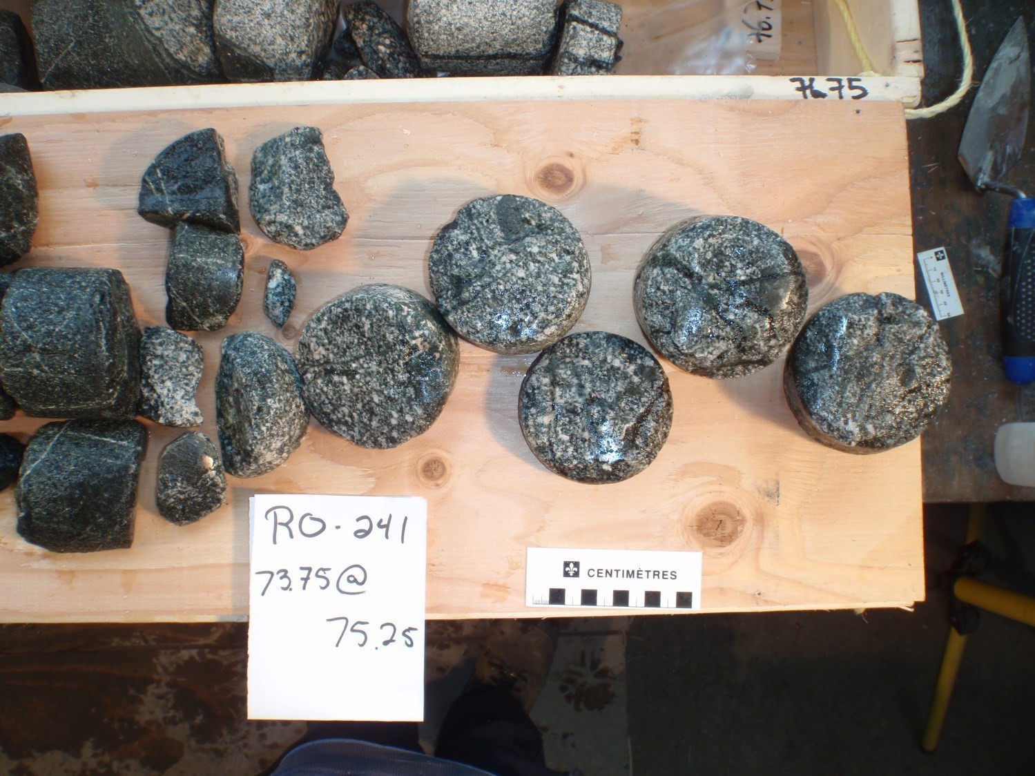
| Reference section: | Sonic drillings RO-240 and RO-241 |
| Type area: | Coigny River area (NTS sheet 32E01) |
| Geological province: | Superior Province |
| Geological subdivision: | Abitibi Subprovince |
| Lithology: | Diorite |
| Category: | Lithodemic |
| Rank: | Lithodeme |
| Status: | Formal |
| Use: | Active |
None
Background
This dioritic intrusion is little known due to the lack of outcrops resulting from the relatively large Quaternary cover. Deschênes and Allard (2014) initiated their description based on data from the Octave River sonic drilling project. Based on the reanalysis of available data, Guemache (2020) proposes the name Coigny Pluton after a river located ~2 km further north.
Description
Using the two sonic drillings RO-240 and RO-241 that intercepted the pluton – which are the only direct observation of this intrusion to date – Deschênes and Allard (2014) described a massive dioritic unit (lithological label I2Ja), which is coarse-grained at the centre and generally medium-grained towards the edge. According to Guemache (2020), this unit has a dioritic to monzodioritic composition and is massive to foliated, banded in places. The greenish grey melanoratic rock is mainly composed of plagioclase, hornblende and minor K-feldspar. It locally shows a porphyraceous texture associated with the presence of plagioclase phenocrystals. Clinopyroxene and biotite are ubiquitous and associated with amphibole. Under the microscope, the mineralogical assemblage includes more or less sericitized plagioclase, scarce microcline (<15%), hornblende (10-40%), biotite (10-20%) and clinopyroxene (5-10%). Quartz is scarce (<5%). Pyroxene grains are commonly surrounded by an amphibole rim (poikiloblastic actinolite or green hornblende), indicating an uralitization process. The rock contains relatively abundant epidote and titanite, as well as apatite, zircon and magnetite as accessory minerals. Calcite (<5%) is relatively abundant in some areas. Amphibolite enclaves are present, as are small felsic intrusions. The latter are unlikely to be associated with the Bernetz Intrusion as suggested by Deschênes and Allard (2014), due to the syntectonic nature of this large neighbouring intrusion (Guemache, 2020).
Thickness and Distribution
This pluton occupies the eastern end of NTS sheet 32E01. Its near-circular geometry (3 km x 4 km) is clearly visible on high-resolution aeromagnetic maps (Keating et al., 2010; Keating and d’Amours, 2010) due to its high magnetic susceptibility.
Dating
None.
Stratigraphic Relationship(s)
The Coigny Pluton’s geometry favours a late-tectonic to post-tectonic intrusion within the Rivière Octave Formation, dated 2726.3 ±2.4 Ma (Deschênes et al., 2014; Augland et al., 2015).
Paleontology
Does not apply.
References
| Author(s) | Title | Year of Publication | Hyperlink (EXAMINE or Other) |
|---|---|---|---|
| GUEMACHE, M.A. | Synthèse géologique de la région de rivière Octave, Abitibi. MERN. RG 2018-01, 68 pages et 1 plan. | 2020 | RG 2018-01 |
| DESCHÊNES, P.-L. – ALLARD, G. – GUEMACHE, M.A. |
Révision de la géologie de la région de la rivière Wawagosic (parties des SNRC 32D15 et 32E02). Ministère de l’Énergie et des Ressources naturelles, Québec; RP 2014-04, 20 pages. |
2014 | RP 2014-04 |
| AUGLAND, L.E. – DAVID, J. – PILOTE, P. – LECLERC, F. – GOUTIER, J. – HAMMOUCHE, H. – LAFRANCE, I. – TALLA TAKAM, F. – DESCHÊNES, P.-L. – GUEMACHE, M.A. |
Datations U-Pb dans les provinces de Churchill et du Supérieur effectuées au GEOTOP en 2012-2013. Ministère de l’Énergie et des Ressources naturelles, Québec; RP 2015-01, 43 pages. |
2015 | RP 2015-01 |
| DESCHÊNES, P.-L. – ALLARD, G. |
Révision de la géologie de la région de la rivière Octave (SNRC 32D16 et 32E01). Ministère de l’Énergie et des Ressources naturelles, Québec; RP 2014-02, 14 pages. |
2014 | RP 2014-02 |
| KEATING, P. – LEFEBVRE, D. – RAINSFORD, D. – ONESCHUCK, D. |
Série des cartes géophysiques, parties des SNRC 31, 32, 41 et 42, Ceinture de roches vertes de l’Abitibi, Québec et Ontario. Ministère des Ressources naturelles et de la Faune, Québec; DP 2010-05, 8 pages, 2 plans. |
2010 | DP 2010-05 |
| KEATING, P. – D’AMOURS, I. | Réédition des données numériques en format Géosoft (profils) des levés aéroportés de l’Abitibi, au Québec. Ministère des Ressources naturelles et de la Faune, Québec; DP 2010-09, 6 pages, Digital data. | 2010 | DP 2010-09 |


