

Last modified: 31 October 2023
DISCLAIMER: This English version is translated from the original French. In case of any discrepancy, the French version shall prevail.
| Author(s): | Mathieu et al., 2018 |
| Age: | Paleoproterozoic |
| Stratotype: | None |
| Type area: | Point Le Droit area (NTS sheet 24P) |
| Geological province: | Nain Province |
| Geological subdivision: | Burwell Lithotectonic Domain |
| Lithology: | Olivine websterite |
| Category: | Lithodemic |
| Rank: | Suite |
| Status: | Formal |
| Use: | Acive |
None
Background
Van Kranendonk et al. (1994) and Van Kranendonk and Wardle (1994) mapped ultramafic lithologies that they associate with the Tasiuyak Gneiss and Noodleook Complex in the Lorière Lake (NTS sheet 24P10) and Ryans Bay (sheet 24P09) area. Mathieu et al. (2018) corroborate these observations in the Point Le Droit area (sheet 24P) and Grenfeld Sound area (sheet 25A). They also map websterites in rocks of the Killinek Suite and introduce the Lepers Suite to group ultramafic intrusions of the Burwell Lithotectonic Domain spatially associated with both metasedimentary rocks and gneiss and intrusions.
Description
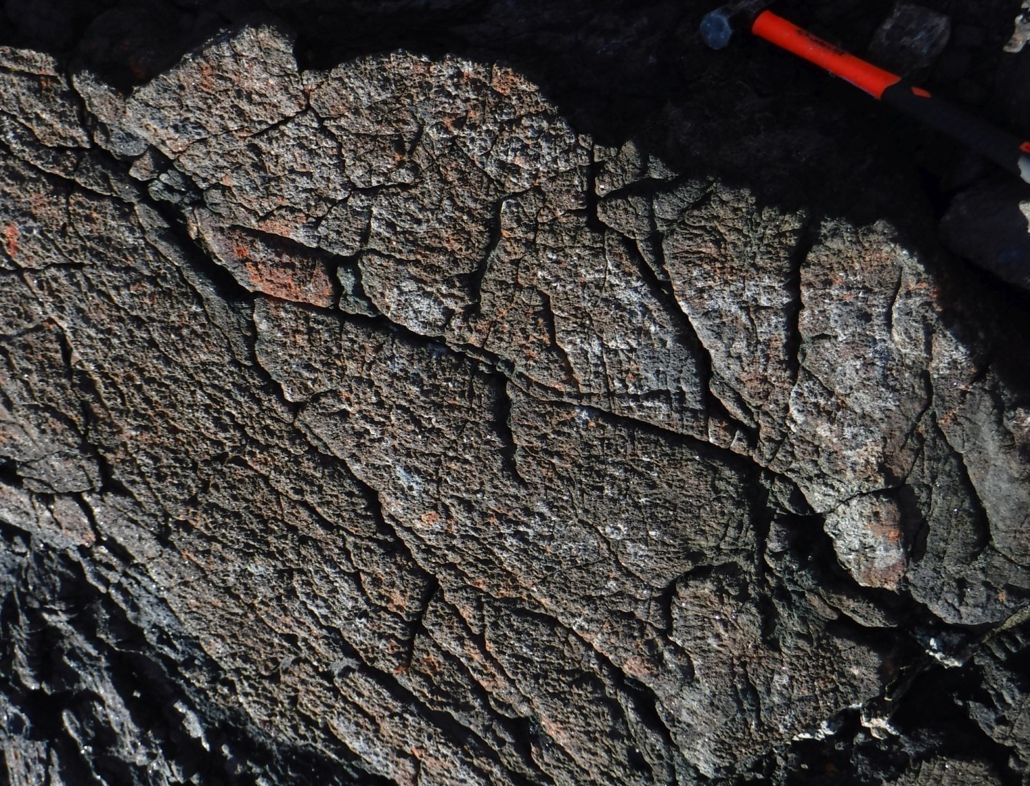
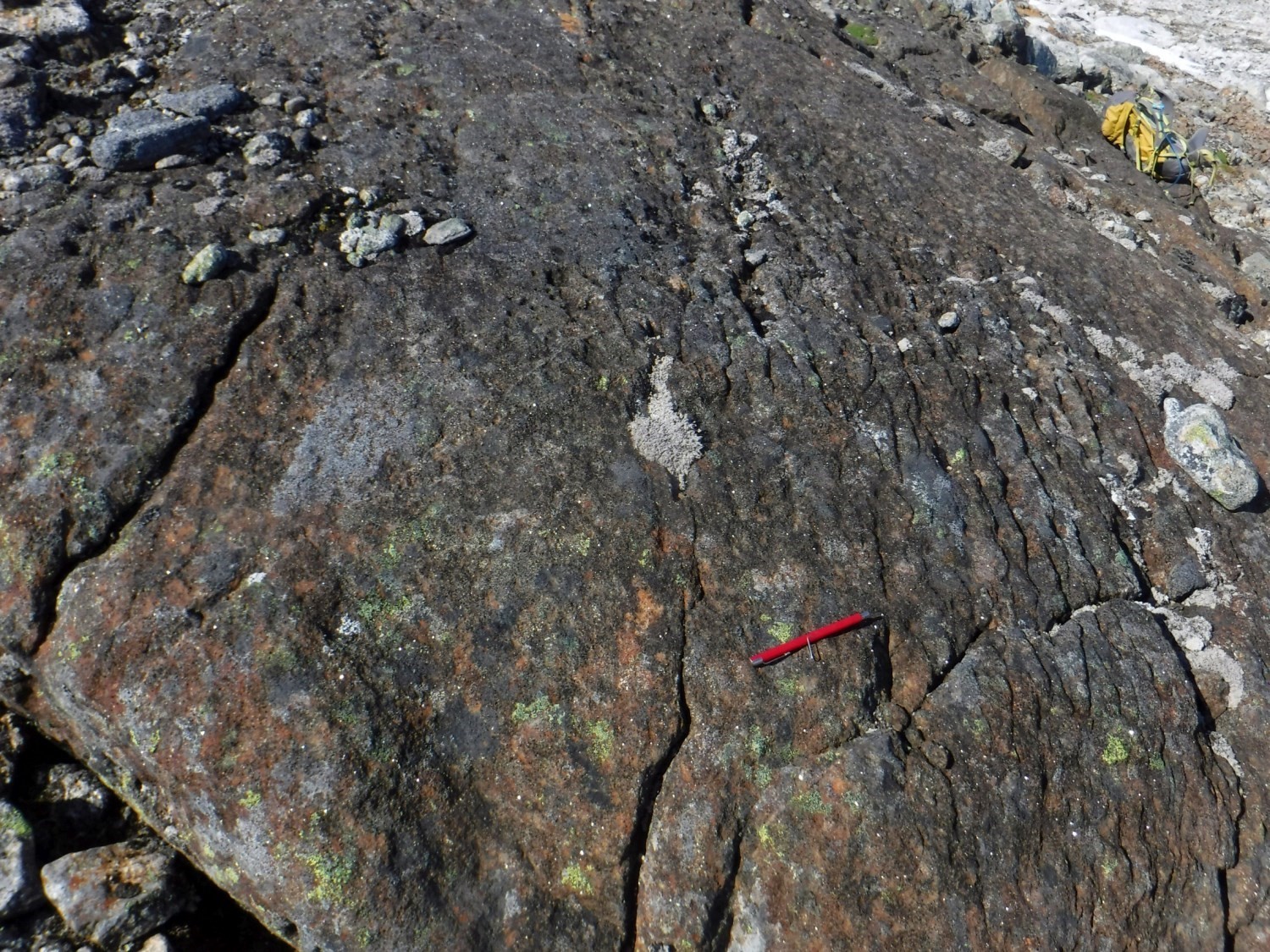
The Lepers Suite consists solely of a metamorphosed ultramafic intrusive rock unit. Samples show high magnetic susceptibility but the small size of intrusions, combined with a very wide mesh aeromagnetic survey, makes it impossible to separate this unit based on the geophysical survey (Geological Survey of Canada, 1985). However, rocks are easily visible in the field due to the whaleback appearance of outcrops, their dark brown patina and elephant skin texture. Some magmatic textures, such as cumulate horizons, are generally preserved despite deformation and metamorphism. Outcrops are homogeneous and only composed of olivine websterite and show magmatic bedding. Serpentine veins and magnetite ridges are frequently observed. Bands of olivine-relic cumulate are reported. The patina is dark brown and the rock is very dark green in fresh exposure.
Preserved primary phases are surrounded by a finer, even-grained matrix composed mostly of actinolite, clinopyroxene and orthopyroxene. Rocks are composed of actinolite (25-30%), orthopyroxene partially replaced by iddingsite and carbonates (20-50%), partially serpentinized olivine (5-30%), clinopyroxene (5-20%), magnetite (5-10%) and green (herspinitis) and locally brown (picotite) spinel. Orthopyroxene and clinopyroxene are medium to coarse grained with a finer granoblastic rim. They incorporate oxides in slats into the cleavage of the preserved core. Orthopyroxene and olivine are altered to iddingsite and serpentine, respectively, matted or in veins. Olivine is cracked and also forms coarse-grained zones. Opaque minerals are disseminated homogeneously. Foliation is marked by a slight preferential orientation of stocky actinolite.
Thickness and Distribution
Intrusive and metamorphosed rocks of the Lepers Suite are observed east and north of the Abloviak Shear Zone. They form oblong masses of reduced size, 10 to 200 m long for a few metres to a few decametres wide.
Dating
None.
Stratigraphic Relationship(s)
Rocks of the Lepers Suite are observed in contact with migmatitic paragneiss of the Tasiuyak Complex and also with orthopyroxene quartz diorite of the Killinek Suite.
Paleontology
Does not apply.
References
Publications available through SIGÉOM Examine
MATHIEU, G., LAFRANCE, I., VANIER, M.-A., 2018. Géologie de la région de pointe Le Droit, Province de Nain et sud-est de la Province de Churchill, Nunavik, Québec, Canada. MERN; BG 2018-07, 4 plans.
Other publications
COMMISSION GÉOLOGIQUE DU CANADA (CGC), 1985. Magnetic anomaly map, Torngat Mountains, Newfoundland and Quebec / Carte des anomalies magnétiques, Torngat Mountains, Terre – Neuve et Québec. Commission géologique du Canada; série nationale des sciences de la Terre, cartes des anomalies magnétiques NO-20-M; 1 plan. https://doi.org/10.4095/120288
VAN KRANENDONK, M.J., WARDLE, R.J. 1994. Geology, Ryans Bay, Newfoundland (Labrador)-Quebec. Commission géologique du Canada; dossier public 2926, 1 carte. https://doi.org/10.4095/194834
VAN KRANENDONK, M.J., WARDLE, R.J., MENGEL, F.C., CHURCHILL, R., CAMPBELL, L.M., SCHWARTZ, S. 1994. Geology, Lac de Lorière, Newfoundland (Labrador)-Quebec. Commission géologique du Canada; dossier public 2925, 1 carte. https://doi.org/10.4095/194833
Suggested Citation
Ministère des Ressources naturelles et des Forêts (MRNF). Lepers Suite. Quebec Stratigraphic Lexicon. https://gq.mines.gouv.qc.ca/lexique-stratigraphique/province-de-nain/suite-de-lepers_en [accessed on Day Month Year].
Contributors
|
First publication |
Guillaume Mathieu, Geology Engineer, M. Sc. guillaume.mathieu@mrnf.gouv.qc.ca (redaction) Mehdi A. Guemache, P. Geo., Ph. D. (coordination); Simon Auclair, P. Geo., M. Sc. (critical review and editing); Céline Dupuis, P. Geo., Ph. D. (English version); Yan Carette (HTML editing). |