

Last modified:
Background
The Labrador Trough is also known as the “New Quebec Orogen” in many papers and reports covering its geology. It is named after the Labrador territory, which is the main land mass of the province of Newfoundland and Labrador. The Labrador Trough is also commonly referred to as the “Trough” by the many geologists who work or have worked in the area.
Expeditions of Father Louis Babel to the northern Gulf of St. Lawrence in the 1860s likely led to early references to the presence of ferriferous rocks in the Labrador Trough (Clark and Wares, 2004). Between 1892 and 1895, explorer and geologist Albert Peter Low made the first geological observations for the Geological Survey of Canada. Since 1929, research and discovery of iron deposits have led to numerous geological surveys on this territory. Most of the Labrador Trough was mapped at 1:50,000 and 1:63,360 scales by geological services in Quebec, Newfoundland and Labrador and Canada. These maps are supplemented by compilations of selected areas at 1:100,000 (Dimroth, 1978; Wardle, 1982) and 1:250,000 (Taylor, 1979) scales. The geology of the Trough and the southern part of its hinterland in Quebec was also compiled at a scale of 1:250,000 by Clark et al. (1990). Other areas of economic interest have also been the subject of extensive work by mining companies, including IOC, Labrador Mining and Exploration, and Hollinger North Shore Exploration.
The first stratigraphic and structural syntheses of the Labrador Trough were produced by Dimroth (1970a, 1972, 1978, 1981), Dimroth et al. (1970), Dimroth and Dressler (1978), Harrison et al. (1970), and Wardle and Bailey (1981). The Trough was subdivided into three segments of supracrustal rocks: the miogeosynclinal western strip, the eugeosynclinal central strip and the hinterland eastern strip. Dimroth (1970a) created the first image of the New Quebec Orogen structural style. Its interpretations were later clarified or modified by work in the central and northern parts of the orogen (e.g., Dressler, 1979; Clark, 1988; Brouillette, 1989; Boone and Hynes, 1990; Wares and Goutier, 1989, 1990; Goulet, 1995; Madore and Larbi, 2000). In their lithotectonic and metallogenic synthesis of the New Quebec Orogen, Clark and Wares (2004) standardized the stratigraphic nomenclature of the Quebec portion of the Labrador Trough and divided the Kaniapiskau Supergroup (Frarey and Duffell 1964) into three cycles, two volcano-sedimentary cycles at the base, overlain by a cycle of molasse-type metasedimentary rocks. They also subdivided the orogen into eleven lithotectonic zones, most of which are allochtonous and limited by thrust faults or erosional discordances.
Since 2011, a review of Labrador Trough geological maps using high resolution magnetic maps and RapidEye satellite images has been underway at Géologie Québec. Preliminary observations and interpretations from the review of airborne geophysical survey data were made by Clark and Amours (2012). In the summer of 2017, a new 1:50,000 scale geological survey was conducted in the Kangirsuk area covering the northern end of the Labrador Trough and part of the Archean Minto Subprovince. The work has improved the historic geological map and enhanced the mineral potential of this region (Bilodeau and Caron-Côté, 2017).
Description
The Labrador Trough is the foreland (western part) of the New Quebec Orogen, which is divided into two major lithotectonic domains, the Labrador Trough in the west and the Rachel-Laporte Zone in the east. The Trough is also an important part of the Trans-Hudsonian Orogen, which is a large orogenic belt extending northeast from North Dakota to Greenland, and which corresponds to the Churchill Province in its Quebec portion. Rocks of the Labrador Trough extend approximately 850 km from the Grenville Front in the south to the western shore of Ungava Bay in the north. The Trough is limited to the west and north by the Superior Province, to the south by the Grenville Front and to the east by the Rachel-Laporte Zone.
Geology
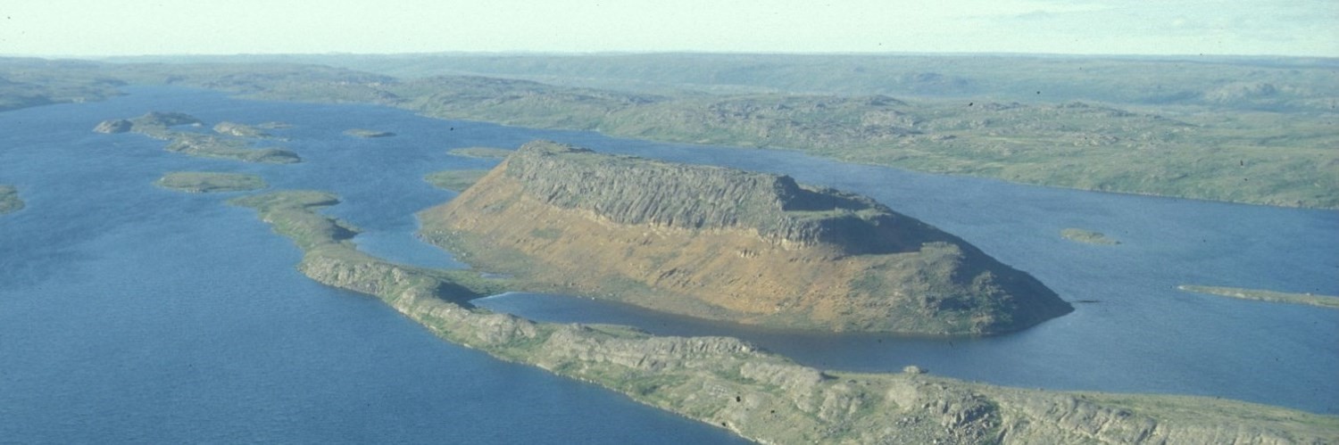
The Labrador Trough is a southwest-verging volcano-sedimentary belt that was folded and transported over rocks of the northeastern margin of the Superior Province during the Paleoproterozoic New Quebec Orogenesis (Clark, 1994; Hoffman, 1990). It primarily consists of greenschist and amphibolite facies sedimentary and igneous rocks that range in age from 2.17 to 1.87 Ga (Rohon et al., 1993; Machado et al., 1997). These rocks have formed in a wide variety of environments, including rifts, continental platforms and slopes, ocean basins and river environments (Clark, 1994). This has resulted in a wide variety of sedimentary rocks, the best known being iron formations of the Schefferville area. The Trough also includes several horizons of basaltic lava, numerous mafic and ultramafic sills of tholeitic affinity, as well as mafic to felsic units of alkaline affinity. Finally, there is the presence of a 15 km-long carbonatite complex, the Le Moyne Carbonatite, hosted in a sequence of rhyodacite flows, highly potassic volcanics and basalts associated with dolomitic and pelitic sedimentary rocks.
The Labrador Trough comprises two large sedimentation and volcanism cycles and a third sedimentation cycle that consists of the Kaniapiskau Supergroup (Frarey and Duffell, 1964) (simplified stratigraphic section). The first cycle consists of an intracratonic basin (rift) sequence overlain by a passive continental margin sequence. First-cycle deposits consist of sandstone and conglomerate of the Seward Group lying on the Archean basement (Superior Province) and representing an immature continental rift sequence. This sequence would have been deposited along the northeastern margin of the Superior Province 2.2 Ga ago (e.g. Hoffman, 1988; Wardle et al., 2002). Volcanic activity was contemporary to sedimentation (Clark and Wares, 2004). The Seward Group is overlain by sandstone and dolomite of the Pistolet Group that have been deposited on a passive margin platform. This platform eventually collapsed and the Swampy Bay Group basalt and flysch sequence was deposited in a marine environment. The end of the first cycle is characterized by marine regression during which the Attikamagen Group dolomitic reef complex was deposited.
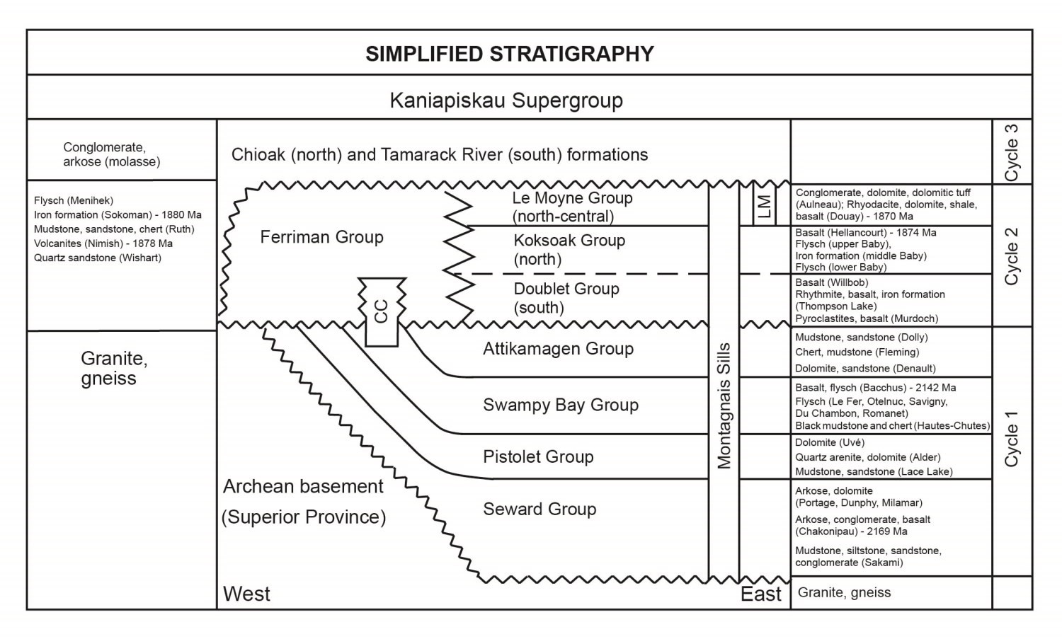
The second cycle, which ranges in age from 1.88 to 187 Ga, begins with a marine transgression characterized by sediments of the Ferriman Group, from base to top: quartzitic sandstone and arenite of the Wishart Formation; mudstone, siltstone and ferriferous sandstone of the Ruth Formation, ferriferous and cherty sedimentary rocks of the Sokoman Formation, and sandstone, mudstone and turbidite of the Menihek Formation (Clark and Wares, 2004; Dimroth, 1978). These rocks unconformably lie on the Superior Province and rocks of the first cycle (Dimroth, 1978). In the south-central part of the Trough, the sequence formed by the Wishart-Sokoman-Menihek formations of the Ferriman Group are time-stratigraphic with basalt and flysch of the Double Group (Clark and Wares, 2004). The northern part of the Trough is formed by the Koksoak Group sequence consisting of turbiditic and ferriferous units of the Baby Formation, at the base, overlain by basalt of the Hellancourt Formation, at the top. The end of the second cycle includes conglomerate and dolomite of the Le Moyne Group that characterize the north-central part of the Trough. Many mafic and ultramafic sills of tholeiitic affinity associated with the Montagnais Intrusive Supersuite cut all of the first and second-cycle sequences. In addition, a significant carbonatite intrusion (Le Moyne Complex) occurred near the end of the second cycle. Second-cycle platform rocks are unconformably overlain by a third and last sedimentary cycle synorogenic molasse sequence.
Clark and Wares (2004) divide the Labrador Trough into eleven lithotectonic zones based on distinctive criteria such as lithological assemblages, structural style and mineral deposit distribution. Three zones correspond to autochtonous and parautochtonous sedimentary rocks (Berard, Cambrien and Tamarack zones), three zones to allochtonous sedimentary rocks (Meleye, Schefferville and Wheeler zones), and five zones to first-cycle (Howse Zone), second-cycle (Payne, Gerido and Retty zones) or first two cycles (Hurst Zone) volcano-sedimentary sequences.
Geological Evolution
Several models of tectonic evolution have been proposed to explain the origin of the Labrador Trough and its hinterland (Wardle and Bailey, 1981; Hoffman, 1987, 1990; Wares et al., 1988; Van der Leeden et al., 1990; St. Seymour et al., 1991; Wares and Skulski, 1992; Skulski et al., 1994). In their synthesis, Clark and Wares (2004) laid the groundwork for the evolution of the Labrador Trough based on previous models and available geochronological data.
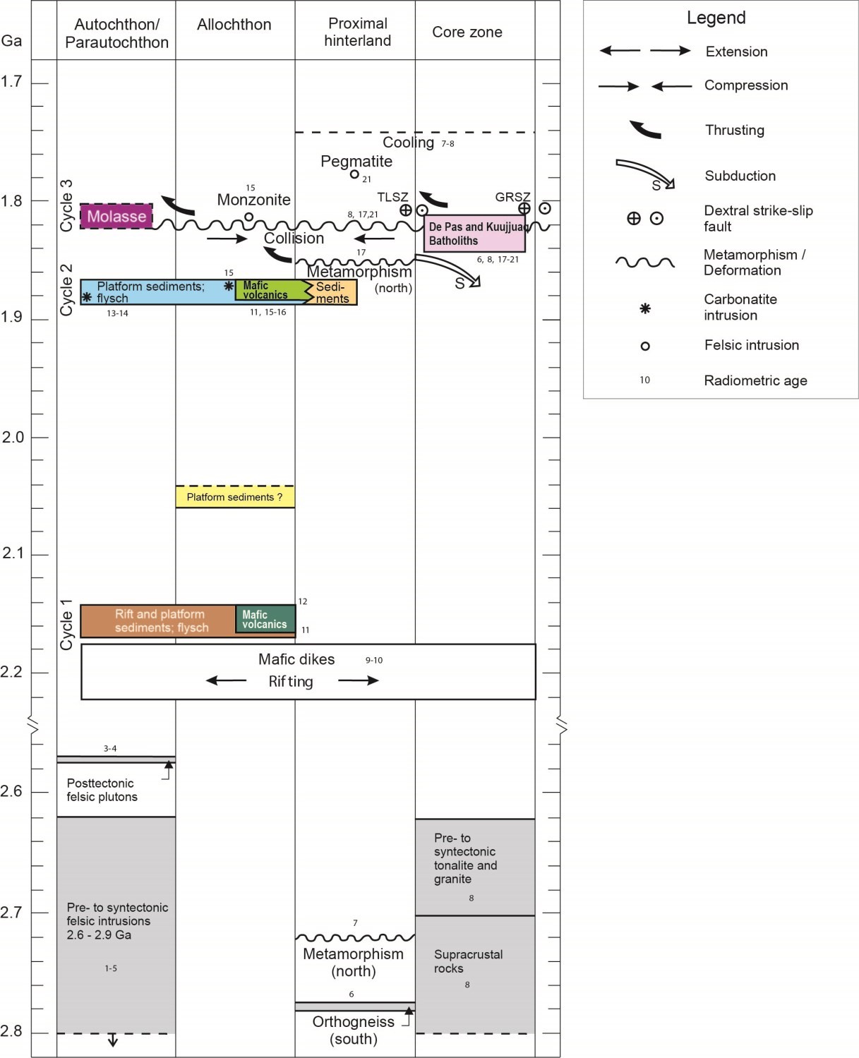
The geological history of the New Quebec Orogen spans several tens of millions of years ranging from ~2.2 to 1.74 Ga (New Quebec Orogen evolution chronology):
- About 2.2 Ga ago, rocks of the western part of the New Quebec Orogen (Labrador Trough) were deposited along the Archean margin of the Superior Province following rifting. This period, which corresponds to the onset of first-cycle sedimentation, is characterized by deposition of immature sediments, slightly alkaline volcanics, and intrusion of mafic dykes;
- Between approximately 2.17 and 2.14 Ga, deposition of passive margin sediments, MORB-like mafic volcanism and intrusion of mafic sills characterize most of the first cycle. The end of cycle (<2.06 Ga) is marked by deposition of dolomite and chert on a restored platform;
- From 1.88 to 1.87 Ga, second-cycle platform and basin sedimentation is associated with a new rifting episode or development of a fore-trough basin. This period is characterized by meimechite and carbonatite deposition, MORB-like mafic volcanism corresponding to the formation of a transitional continental-oceanic crust and intrusion of mafic-ultramafic sills;
- From 1.84 to 1.83 Ga, a deformation and high-grade metamorphism phase occurs in the New Quebec Orogen hinterland near Kuujjuaq. During the same period up to 1.81 Ga, a regional-scale granitic and charnockitic intrusion, the De Pas Supersuite (formerly De Pas Batholith), was emplaced. This supersuite is interpreted by several authors as associated with a Proterozoic magmatic arc environment connected to a subduction zone developed during the New Quebec Orogenesis (Dunphy and Skulsky, 1996; Martelain et al., 1998). According to Wardle et al. (1990, 2002), this supersuite may also be associated with a syncollisional component in the New Quebec Orogen hinterland;
- From 1.82 to 1.77 Ga, there would have been an oblique collision between the Superior craton and the Core Zone of the Churchill Province during the New Quebec Orogenesis. This event resulted in transpressure-type deformation and the formation of a western-verging thrust and fold belt, the Labrador Trough. During this period, molasse-type sediments are deposited on the Superior Province margin in the third cycle;
- Around 1.81 Ga, undeformed and likely post-tectonic small intrusions of monzonite occur in the Labrador Trough;
- Finally, from 1.77 to 1.74 Ga, the hinterland near Kuujjuaq is characterized by pegmatite intrusion and hydrothermal activity followed by a cooling period.
References
| Author(s) | Title | Year of Publication | Hyperlink (EXAMINE or Other) |
|---|---|---|---|
| BILODEAU, C. – CARON-CÔTÉ, E. | Géologie de la région de la rivière Arnaud, provinces du Supérieur (Minto) et de Churchill (Fosse du Labrador), secteur de Kangirsuk, Nunavik, Québec, Canada. Ministère de l’Énergie et des Ressources naturelles, Québec. | 2018 | Bulletin géologiQUE |
| BOONE, E. – HYNES, A. | A structural cross-section of the northern Labrador Trough, New Quebec. In: The Early Proterozoic Trans-Hudson Orogen of North America: Lithotectonic Correlations and Evolution (J.F. Lewry, J.F. and M.R. Stauffer, editors). Geological Association of Canada; Special Paper 37, pages 387-396. | 1990 | – |
| BROUILLETTE, P. | Géologie et métallogénie de la région des lacs Minowean et du Portage (Fosse du Labrador). Ministère de l’Énergie et des Ressources, Québec; ET 88-06, 74 pages. | 1989 | ET 88-06 |
| CLARK, T. | Stratigraphie, pétrographie et pétrochimie de la Formation de Fer de Baby, région du lac Hérodier, Fosse du Labrador. Ministère de l’Énergie et des Ressources, Québec; ET 87-13, 42 pages. | 1988 | ET 87-13 |
| CLARK, T. | Géologie et gîtes de l’Orogène du Nouveau-Québec et de son arrière-pays. Dans : Géologie du Québec (M. Hocq, coordonnateur). Ministère des Ressources naturelles, Québec; MM 94-01, pages 47-65. | 1994 | MM 94-01 |
| CLARK, T. – D’AMOURS, I. | Interprétations structurales et métallogéniques dans la Fosse du Labrador à partir des cartes magnétique et spectrométrique. Ministère des Ressources naturelles; RP 2012-02, 12 pages, 2 plans. | 2012 | RP 2012-02 |
| CLARK, T. – WARES, R. | Synthèse lithotectonique et métallogénique de l’Orogène du Nouveau-Québec (Fosse du Labrador). Ministère des Ressources naturelles de la Faune et des Parcs, Québec; MM 2004-01, 182 pages, 1 plan. | 2004 | MM 2004-01 |
| CLARK, T. – MARCOUX, P. – BÉLANGER, M. – WILSON, C. – AVRAMTCHEV, L. | Carte des gîtes minéraux du Québec, région de la Fosse du Labrador. Ministère de l’Énergie et des Ressources, Québec; DV 84-01, 45 pages, 21 plans. | 1990 | DV 84-01 |
| DIMROTH, E. | Evolution of the Labrador Geosyncline. Geological Society of America Bulletin; volume 81, pages 2717-2742. | 1970 | Source |
| DIMROTH, E. | The Labrador Geosyncline revisited. American Journal of Science; volume 272, pages 487-506. | 1972 | Source |
| DIMROTH, E. | Région de la Fosse du Labrador (54°30′-56°30′). Ministère des Richesses naturelles, Québec; RG-193, 396 pages. | 1978 | RG 193 |
| DIMROTH, E. | Labrador Geosyncline: type example of early Proterozoic cratonic reactivation. In: Precambrian Plate Tectonics (A. Kroner, editor). Developments in Precambrian Geology 4, Elsevier Scientific, Amsterdam; pages 331-352. | 1981 | – |
| DIMROTH, E. – BARAGAR, W.R.A. – BERGERON, R. – JACKSON, GD. | The filling of the Circum-Ungava geosyncline. In: Symposium on Basins and Geosynclines of the Canadian Shield (A.J. Baer, editor). Geological Survey of Canada; Paper 70-40, pages 45-142. | 1970 | Source |
| DIMROTH, E. – DRESSLER, B. | Metamorphism of the Labrador Trough. In: Metamorphism in the Canadian Shield. Geological Survey of Canada; Paper 78-10, pages 215-236. | 1978 | Source |
| DRESSLER, B. | Région de la Fosse du Labrador (56°30′-57°15′). Ministère des Richesses naturelles, Québec; RG-195, 117 pages. | 1979 | RG 195 |
| DUNPHY, J.M. – SKULSKI, T. | Petrological zonation across the De Pas batholith: a tilted section through a continental arc? In: Eastern Canadian Shield Onshore-Offshore Transect (ECSOOT), Report of 1996 transect meeting. R.J. Wardle and J. Hall (compilators). Lithoprobe Report Number 57; pages 44-58. | 1996 | – |
| FRAREY, M.J. – DUFFELL, S. | Revised stratigraphic nomenclature for the central part of the Labrador Trough. Geological Survey of Canada; Paper 64-25, 13 pages. | 1964 | Source |
| GOULET, N. | Étude structurale, stratigraphique et géochronologique de la partie nord de la Fosse du Labrador. Ministère des Ressources naturelles, Québec; MB 95-36, 35 pages. | 1995 | MB 95-36 |
| HARRISON, J.M. – HOWELL, J.E. – FAHRIG, W.F. | A geological cross-section of the Labrador miogeosyncline near Schefferville, Québec. Geological Survey of Canada; Paper 70-37, pages 1-34. | 1970 | Source |
| HOFFMAN, P.F. | Early Proterozoic foredeeps, foredeep magmatism and Superior-type iron-formations of the Canadian shield. In: Proterozoic Lithospheric Evolution (A. Kroner, editor). American Geophysical Union, Geodynamics Series; volume 17, pages 85-98. | 1987 | Source |
| HOFFMAN, P.F. | United Plates of America, the birth of a Craton: Early Proterozoic assembly and growth of Proto-Laurentia. Annual Reviews of Earth and Planetary Sciences; volume 16, pages 543-603. | 1988 | Source |
| HOFFMAN, P.F. | Subdivision of the Churchill Province and extent of the Trans-Hudson Orogen. In: The Early Proterozoic Trans-Hudson Orogen of North America: Lithotectonic Correlations and Evolution (J.F. Lewry and M.R. Stauffer, editors). Geological Association of Canada; Special Paper 37, pages 15-39. | 1990a | – |
| HOFFMAN, P.F. | Dynamics of the tectonic assembly of northeast Laurentia in geon 18 (1.9-1.8 Ga). Geoscience Canada; volume 17, pages 222-226. | 1990b | – |
| MACHADO, N. – CLARK, T. – DAVID, J. – GOULET, N. | U-Pb ages for magmatism and deformation in the New Quebec Orogen. Canadian Journal of Earth Sciences; volume 34, pages 716-723. | 1997 | Source |
| MADORE, L. – LARBI, Y. | Géologie de la région de la rivière Arnaud (SNRC 25D) et des régions littorales adjacentes (SRNC 25C, 25E et 25F). Ministère des Ressources naturelles, Québec; RG 2000-05, 37 pages. | 2000 | RG 2000-05 |
| MARTELAIN, J. – CHENEVOY, M. – BÉLANGER, M. | Le batholite de De Pas, Nouveau-Québec : infrastructure composite d’arc magmatique protérozoïque. Revue canadienne des Sciences de la Terre; volume 35, pages 1-15. | 1998 | Source |
| ROHON, M.-L. – VIALETTE, Y. – CLARK, T. – ROGER, G – OHNENSTETTER, D. – VIDAL, P. | Aphebian mafic-ultramafic magmatism in the Labrador Trough (New Quebec): its age and the nature of its mantle source. Canadian Journal of Earth Sciences; volume 30, pages 1582-1593. | 1993 | Source |
| SKULSKI, T. – PERCIVAL, J.A. – STERN, R.A. | Oceanic allochthons in an Archean continental margin sequence, Vizien greenstone belt, northern Quebec. In: Current Research 1994-C; Geological Survey of Canada, pages 311-320. | 1994 | Source |
| ST. SEYMOUR, K. – KIDDIE, A. – WARES, R. | Basalts and gabbros of the Labrador Trough: remnants of a Proterozoic failed ocean? Neues Jahrbuch fuer Mineralogie, Monatshefte, 1991; Hefte 6, pages 271-280. | 1991 | – |
| TAYLOR, F.C. | Reconnaissance geology of a part of the Precambrian Shield, Northeastern Quebec, Northern Labrador and Northwest Territories. Geological Survey of Canada; memoir 393, 99 pages. | 1979 | Source |
| VAN DER LEEDEN, J. – BÉLANGER, M. – DANIS, D. – GIRARD, R. – MARTELAIN, J. | Lithotectonic domains in the high-grade terrain east of the Labrador Trough (Quebec). In: The Early Proterozoic Trans-Hudson Orogen of North America (J.F. Lewry and M.R. Stauffer, editors). Geological Association of Canada; Special Paper 37, pages 371-386. | 1990 | – |
| WARDLE, R.J. | Geology of the south-central Labrador Trough. Newfoundland Department of Mines and Energy; Mineral Development Division; cartes 82-5 et 82-6. | 1982 | – |
| WARDLE, R.J. — BAILEY, D.G. | Early Proterozoic sequences in Labrador. In: Proterozoic Basins in Canada (F.H.A. Campbell, editor). Geological Survey of Canada; Paper 81-10, pages 331-358. | 1981 | Source |
| WARDLE, R.J. – RYAN, B. – NUNN, G.A.G. – MENGEL, F.C. | Labrador segment of the Trans-Hudson orogen: crustal development through oblique convergence and collision. In: The Early Proterozoic Trans-Hudson Orogen of North America (J.F. Lewry and M.R. Stauffer, editors). Geological Association of Canada; Special Paper 37, pages 353-369. | 1990 | – |
| WARDLE, R.J. – JAMES, D.T. – SCOTT, D.J. – HALL, J. | The southeastern Churchill Province: synthesis of a Paleoproterozoic transpressional orogen. Canadian Journal of Earth Sciences; volume 39, pages 639-663. | 2002 | Source |
| WARES, R. – GOUTIER, J. | Synthèse métallogénique des indices de sulfures au nord du 57° parallèle, Fosse du Labrador : Étape III. Ministère de l’Énergie et des Ressources naturelles, Québec; MB 90-25, 96 pages. | 1990 | MB 90-25 |
| WARES, R. – GOUTIER, J. | Métallogénie des indices de sulfures au nord du 57° parallèle, Fosse du Labrador : Étape II. Ministère de l’Énergie et des Ressources naturelles, Québec; MB 89-38, 122 pages. | 1989 | MB 89-38 |
| WARES, R. – BERGER, J. – ST. SEYMOUR, K. | Synthèse métallogénique des indices de sulfures au nord du 57` parallèle, Fosse du Labrador : Étape I. Ministère de l’Énergie et des Ressources naturelles, Québec; MB 88-05, 186 pages. | 1988 | MB 88-05 |
| WARES, R.P. – SKULSKI, T. | Evolution of the 2.2 – 1.7 Ga New Quebec Orogen. Eos, Transactions American Geophysical Union; volume 73, page 333. | 1992 | – |