Background
The Grenville Province is a geological province of the Canadian Shield. It takes its name from the village of Grenville on the north shore of the Ottawa River in Quebec and corresponds to the Laurentides territory in the province of Quebec. The first uses of the term Grenville came from Logan’s work in 1863, introducing the “Grenville Series” geological unit. The Grenville series refers to a succession of marbles and other metasedimentary rocks mapped during its reconnaissance work along the Ottawa River. The Grenville series replaced the name “Laurentian System” given by Logan and Hunt (1855) to refer to these same rocks. Later, its use was extended in association with all similar rocks north of the St. Lawrence River. Since then, the name “Grenville Series” has been changed to “Grenville Supergroup” which refers to rocks of the central metasedimentary belt in Ontario, northern New York and southwestern Quebec (Wynne-Edwards, 1972).
The concept of subprovince was used by Wilson (1925) to separate Archean terrains (Timiskaming Subprovince) from Proterozoic terrains (Grenville Subprovince) of the Saint-Laurent Province. As soon as K/Ar and Rb/Sr dating techniques were able to establish absolute ages (minimum ages in these cases), the concept of tectonic province took precedence over the old names that became obsolete (Stockwell, 1962, 1969, 1982). Since then, we talk of the Grenville Province. The tectonic discontinuity marking its northwest boundary was studied in western Quebec by Faribault et al. (1912) and in central Ontario by Collins (1925). This discontinuity was later named “Huron-Mistassini Fault Zone” by Wilson (1949) and then “Grenville Front” by Derry (1950).
The first subdivision of the internal nature of the Grenville Province was developed by Stockwell (1964) based on identification of segments that gave different pre-grenvillian ages. Wynne-Edwards (1972) then divided the province into seven main domains, highlighting a narrow corridor parallel to the Grenville Front, the “Grenville Front Tectonic Zone”. Although it dates back more than 30 years, several elements of Wynne-Edwards’ (1972) terminology are still used in the current literature. Later, Rivers et al. (1989) subdivided the Grenville Province into three domains based on tectonic, magmatic and metamorphic criteria: Parautochton, polycyclic Allochton and monocyclic Allochton. The terms “monocyclic” and “polycyclic” are based on the presence or absence of Pregrenvillian fabric. Specifically, the polycyclic Allochton consists of rocks that have undergone the different Pregrenvillian orogeneses, while the monocyclic Allochton is thought to correspond instead to supracrustal rocks that have undergone only one orogenic phase (the Grenvillian Orogenesis). As it is now recognized that Grenvillian metamorphism is highly variable in intensity and age along the Grenville Province (Rivers et al., 2012), monocyclic and polycyclic terms are no longer used.
Gower and Krog (2002) proposed a classification of geological periods based on orogenesis (with dominant compression) and anorogenic events (with dominant extension) and applicable to eastern Grenville. The evolution of this part of the Grenville would take place over several million years, from Prelabradorian to Grenvillian. Another classification based on geological eons involving a geological time scale (Hofmann, 1990) is used in establishing tectonic environments in the Grenville (e.g., Rivers, 1997; Indares and Moukhsil, 2013).
Description
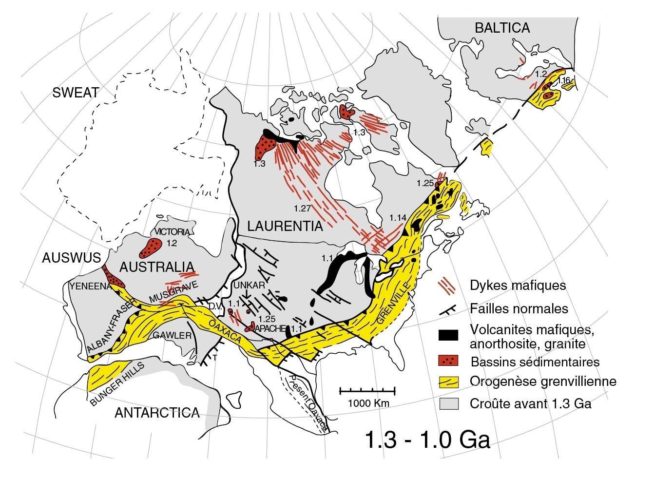
The Grenville Province represents the footprint of the last tectonic event (orogenesis) to shape the Canadian Shield. The Grenville was built step by step along the eastern margin of the Laurentia continent (continental core of North America). It is the root of an ancient mountain range comparable to the present Himalayas (Windley, 1986). This mountain range would have resulted from a continental-continental collision between Laurentia and Amazonia (1090-980 Ma; e.g. Rivers et al., 1989, 2012).
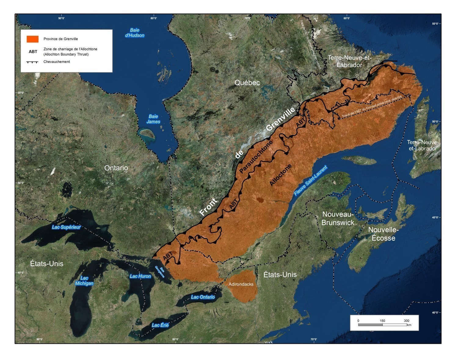
In Canada, the Grenville Province extends more than 2,000 km in a NE direction between the Great Lakes, SW, and Labrador, NS, with an average width of 350 km. It corresponds to the longest continuous segment of a late Mesoproterozoic belt in the world (Wynne-Edwards, 1972; Davidson, 1995).
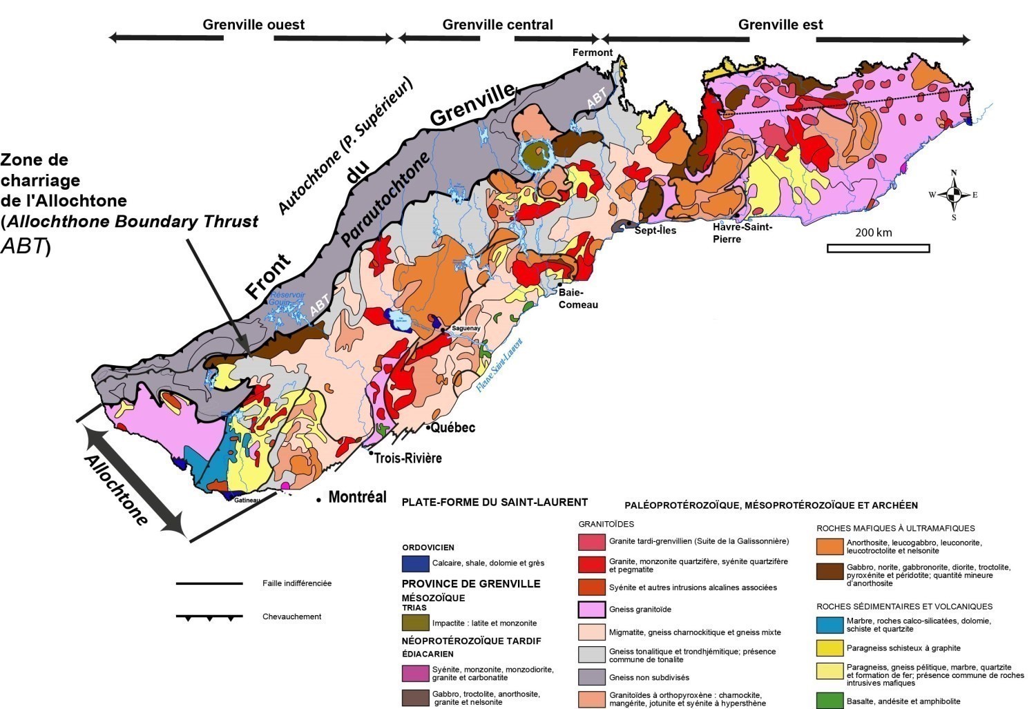
In Quebec, the Grenville Province occupies a very large territory of nearly 495,000 km2. It is restricted to the north by the Superior and Churchill provinces and to the south by sedimentary rocks of the St. Lawrence Platform and the Appalachian Province. The Grenville Front, clearly visible on aeromagnetic maps, separates the Grenville Province from the Superior Province. Geographically, the Grenville Province is subdivided into three parts: west, central and east. The western part of Grenville arbitrarily extends from Trois-Rivières to the Ontario border. The eastern part occupies the Sept-Îles region to Labrador (Newfoundland) and the central part lies between the two, from Sept-Îles in the east to Trois-Rivières in the west (Moukhsil and Solgadi, 2018).
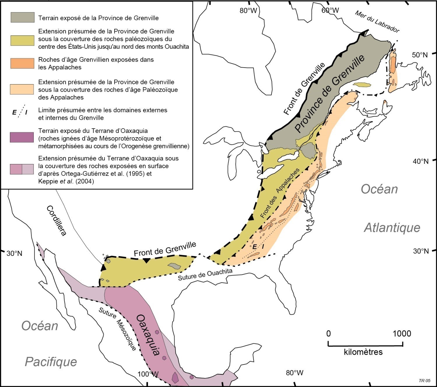
Outside the Canadian Shield, the Grenville Province stretches southwest to Texas and Mexico. South of the Great Lakes, it extends beneath the Paleozoic rock cover of central United States to the north of the Ouachita Mountains, east of the Precambrian Yavapai and Mazatzal provinces (Hoffman, 1988, 1989). Precambrian rocks of Grenvillian age are also imbricated in the Appalachians. They form the Long Range large slice in the Humber Zone, Newfoundland, and other slices in Taconic fault zones in Quebec. In eastern and southern Mexico, Mesoproterozoic rocks metamorphosed during the Grenvillian Orogenesis are exposed south of the Ouachita Suture (Cameron et al., 2004).
Beyond North America, the Grenville Province has been recognized inside exhumed anticlinal inliers in the Caledonia of Northern Ireland, Scotland, and then in Norway and the Sveconorwegian Province in Scandinavia (Davidson, 1998; Lorenz et al., 2012). According to several authors, it would continue from Central America to Antarctica, and from India to Australia (e.g. Karlstrom et al., 1999).
Geology
In Quebec, the Grenville Province is divided into two parts, the Parautochton and the Allochton. The two zones are separated by a major thrust structure called the Allochton Bundary Thrust (ABT) (Rivers et al., 1989). The Parautochton is composed of mostly Archean rocks in contact with rocks of the Superior Province and limited to the northwest by the Grenville Front located near the Grenvillian Range. The Allochton is composed of Paleoproterozoic to Mesoproterozoic rocks. The Grenville Province largely lies on gneiss complexes of high-grade metamorphic rocks with polyphase ductile deformation and significant partial melting. It also contains the largest quantity (75%) and largest known anorthositic intrusions in the world (Ashwal and Wooden, 1983).
The Grenville Front is a major discontinuity of the North American continent resulting from the collision of the Allochton with the existing rocks (Autochton) in southeastern Superior Province. It is generally accepted that the Grenville Front is the first major manifestation of Archean rock deep crustal horizon uplift (Rivers et al., 1989; Indares and Martignole, 1989). The Grenville Front is a fracturation and mylonitization zone along heavily to moderately inclined surfaces to the southeast and south. This zone indicates a shift from brittle deformation to ductile deformation towards the orogen (Davidson, 1998). The Grenville Front is not a single fault or a well-defined mylonitization zone along its entire length, although this may be the case in some areas. In the Lagacé Lake area (NTS sheet 32B14), the Grenville Front is marked by the Buteux Fault. Archean planar and linear elements of the Parautochton are gradually reoriented from north to south, from an early E-W attitude marking the effects of the Kenyan Orogenesis to a final NE-SW attitude reflecting the effects of the Grenvillian Orogenesis (Bandyayera et al., 2004). Further east, in the Vallard Lake area (sheet 23C), the transition between rocks of the Parautochton and those of the Superior Province is characterized by a narrow mylonitization corridor (Lamothe et al., 1998).
Geological Evolution
The geological history of the Grenville Province spans several hundred million years. In the eastern and western parts of Grenville, several tectonic models were proposed by different authors (Rivers, 1997; Rivers et al., 1989; Dickin and Higgins, 1992; Gower, 1996; Carr et al., 2000; Dickin, 2000; Hanmer et al., 2000; Rivers and Corrigan, 2000; Gobeil et al., 2003; Gower and Krogh, 2002; Perreault and Heaman, 2003; Hynes and Rivers, 2010; Rivers et al., 2012; Corriveau, 2013; Rivers, 2014). In its central section, descriptions of geological episodes based on isotopic datings were published by Hébert et al. (2009) in the synthesis of sheet 22E north of Saguenay city. The geological history presented here comes from the work of Moukhsil and Solgadi (2018). These authors, based on the classification of Gower and Krogh (2002), propose a geodynamic model based on the different orogeneses and events that affected the Grenville Province from 1900 to 986 Ma.
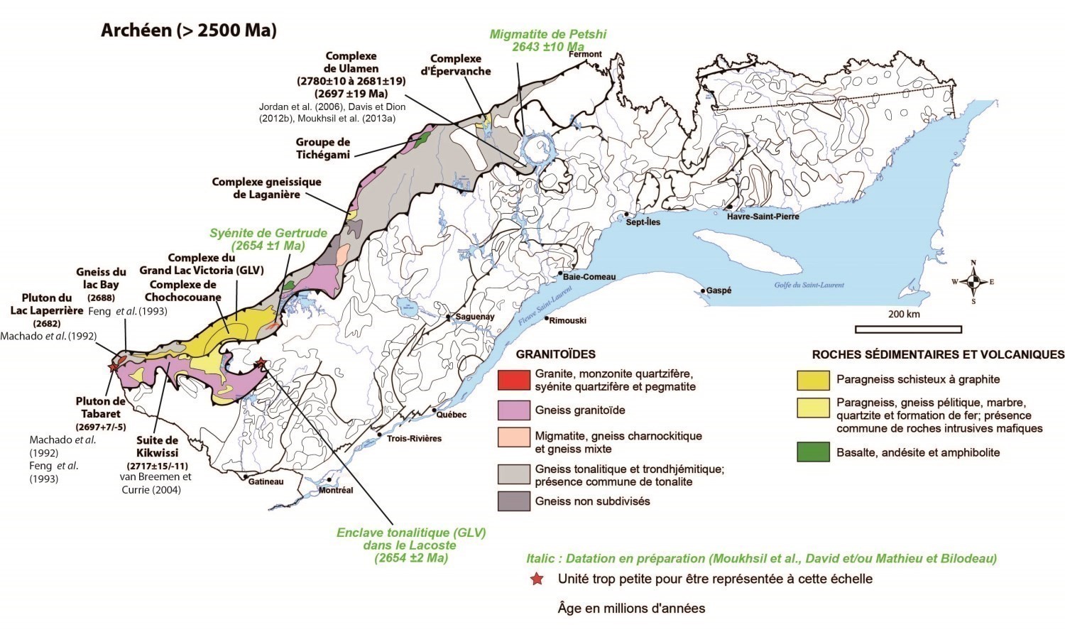
Archean (>2500 Ma)
The Parautochton is composed of ancient rocks older than 2,500 Ma. They are supracrustal (metasedimentary and metavolcanic) and highly deformed plutonic rocks. These rocks are correlated with those less deformed north of the Grenville Front (e.g. Superior Province) and correspond to their E-W oriented lateral extension. In the Manicouagan Reservoir region, the Ulamen Complex corresponds to the parauchtonous domain. Indeed, gneiss of the Ulamen Complex consist of a metaluminous trondhjemite-granodiorite-granite (TTG) suite that coincides with the domain of igneous-type granites and volcanic arc granites, as in the case of Archean intrusions of the Abitibi Greenstone Belt (e.g. Moukhsil, 1996; Chown et al., 2002).
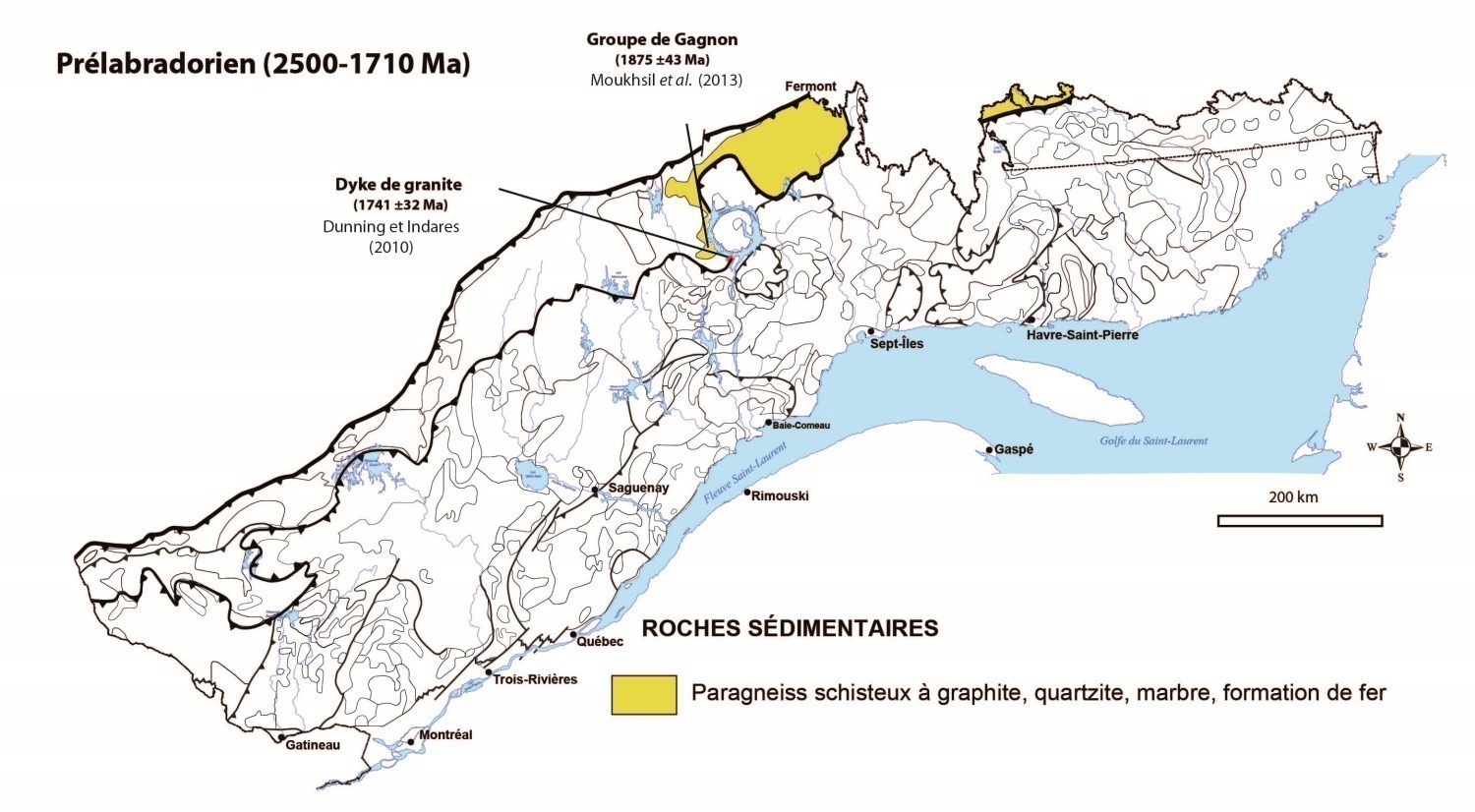
Prelabradorian Orogenesis (1900-1710 Ma)
The Prelabradorian spanned a period of 200 Ma. This period was defined by Gower and Krogh (2002) primarily in eastern Grenville, located in Labrador. In fact, the Prelabradorian is expected to correspond to the ages of rocks contained in a range between 2500 Ma and 1710 Ma. Gower (2012) cites several Prelabradorian rock settings, such as the Eagle River Orogenic Event (1810-1770 Ma). Granitoids also intruded in the Mealy Mountains Terrane between 1782 and 1712 Ma (Gower and Krogh, 2002). In Quebec, during the Prelabradorian period (1900-1710 Ma), only the Gagnon Group (quartzite dated 1875 ±43 Ma) was recognized in the northern part of central Grenville; it would be the equivalent of rocks of the Labrador Trough (Clarke, 1977; Rivers, 1980). On the other hand, other rocks of the same age have been recognized in the western area of the Parautochton in Ontario. All of these rocks unconformbly lie on Archean rocks. In the Manicouagan region, the discordance between the Gagnon Group and Archean rocks is not observable because the Grenvillian deformation in Mesoproterozoic has transposed contacts (discordances), in addition to dismembering Paleoproterozoic units (Moukhsil et al., 2013a). In the field, paragneiss of the Gagnon Group are interbedded with Archean tonalites. The study of sulphur isotopes on these paragneiss has allowed the estimation of their Proterozoic age (Wing et al., 2012). Eclogites were observed north of the Manic 5 Reservoir (Cox et al., 1998), indicating very deep burial of rocks in this region before their final emplacement. It should be noted that during the Prelabradorian, mainly between 1900 and 1790 Ma, a series of accretional orogeneses, such as the Penokean, Makkovikian and Ketilidian orogeneses, affected the Laurentia continent (Gower and Krogh, 2002, 2003).
Labradorian Event (~1710 and 1600 Ma)
The Labradorian was introduced by Gower and Krogh (2002, 2003) for the eastern part of Grenville, located in Labrador, to define a range of events corresponding to accretion in a volcanic arc environment. The Labradorian covers a period of 110 Ma and plutonic intrusions of this age are observed in eastern Quebec, such as the Deep Cove Megacristic Granite and Mealy Mountains Intrusive Suite. In central Grenville, the Molson Lake Terrane was dated in Labrador 1651 ±5 Ma (Gower et al., 1992) and appears to continue in Quebec. In the vicinity of the Manicouagan Reservoir, one can observe: (1) mafic magmatism with intrusion of the protolith behind mafic klippes (metagabbro, metagabronorite and anorthosite) contained in the Canyon Complex, south of the Daniel-Johnson Reservoir (Manic 5) (1694 Ma; Dunning and Indares, 2010; Moukhsil et al., 2013a); 2) emplacement of the Lelukuan Complex (~1630-1650 Ma; Dunning and Indares, 2010); and 3) emplacement of one of the first anorthositic intrusions in Grenville, the Seignelay Anorthosite (1692 ±85 Ma; Indares et al., 1998). The geochemistry of a metagabbronorite sample in a mafic klippe the Canyon Complex suggests a volcanic arc environment setting. The same environment was established for the Mealy Mountains Intrusive Suite (1660 +11/-9 Ma; Gower and Krogh, 2003; Gower, 2012) and the Deep Cove Megacristic Granite at 1632 Ma east of Blanc-Sablon. According to Gower and Krogh (2002, 2003) and Gower (2012), the following events allegedly took place during the Labradorian event on the Labrador side:
- following a collision, calc-alkaline felsic magmatism characterized by intrusion of the Translabradorian batholith (1654-1646 Ma) and granites of the Molson Lake Terrane (1645-1651 Ma);
- continuous crustal thinning that favoured trimodal magmatism (mafic, anorthositic and monzogranitic; ~1650-1620 Ma);
- accretion of an external arc favouring the development of a passive margin (1600 Ma).
These events defined during the Labradorian could also have occurred in central Grenville. However, this model cannot be confirmed in the central part due to the lack of geochronological data.
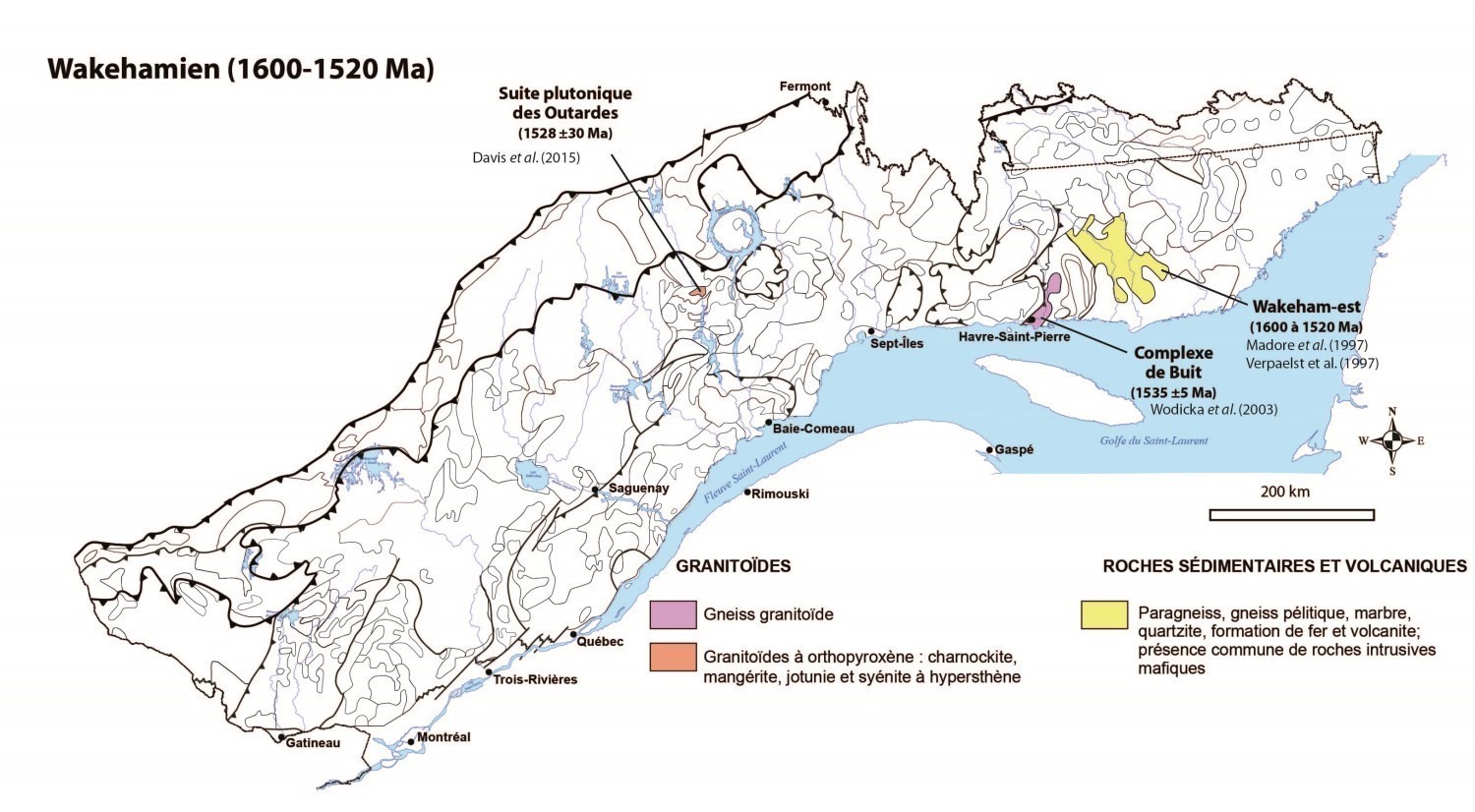
Wakamian Event (1600-1520 Ma)
The Wakamian or Wakehamian event covers a period of 80 Ma and was documented by Gobeil et al. (2003) during synthesis work in the eastern part of Grenville (between Sept-Îles and Havre-St-Pierre). Gower and Krogh (2002) did not recognize significant Wakehamian magmatic or sedimentary activity in the extreme eastern Grenville. In the central part, Moukhsil et al. (2011, 2012) recognized a magmatic activity that saw intrusion of the Outardes Plutonic Suite (1528 ±30 Ma) which is within the Wakehamian age range, at the same time as rocks of the Wakeham-est Group and Buit Complex (1535 ±5 Ma, Wodicka et al., 2003). In the eastern part of Grenville, it was established by Gobeil et al. (2003) that the Wakamian corresponds to a deposition event in a back-arc basin. The Wakehamian, which, in terms of age, lies between the Labradorian and Pinwarian, should be a passive margin tectonic environment following cessation of subduction at the end of the Labradorian (1600 Ma; Gower and Krogh, 2002). The age of 1528 ±30 Ma (Davis et al., 2015; Moukhsil et al., 2013b) obtained for the Outardes Plutonic Suite is unclear; and if you take into account -30 Ma, then the estimated age of this suite could be as high as 1498 Ma, which would coincide with the Pinwarian (1520-1460 Ma), which is one of the most represented orogenesis in the eastern and central parts of Grenville. This suggests that the Pinwarian orogenesis is early in central Grenville. The rock geochemistry of this suite shows an extensional intraplate tectonic environment signature that is identical to that established for igneous rocks of the Buit Complex (Madore et al., 1999). It should be noted that several authors, including van Breemen and Corriveau (2005) and Bonnet et al. (2005), suggest that volcanism recognized in the southeast part of the Wakeham Group is due to Pinwarian magmatic tectonic activity. These rocks were dated 1520 Ma (volcanic rocks) and 1500 Ma (sedimentary rocks).
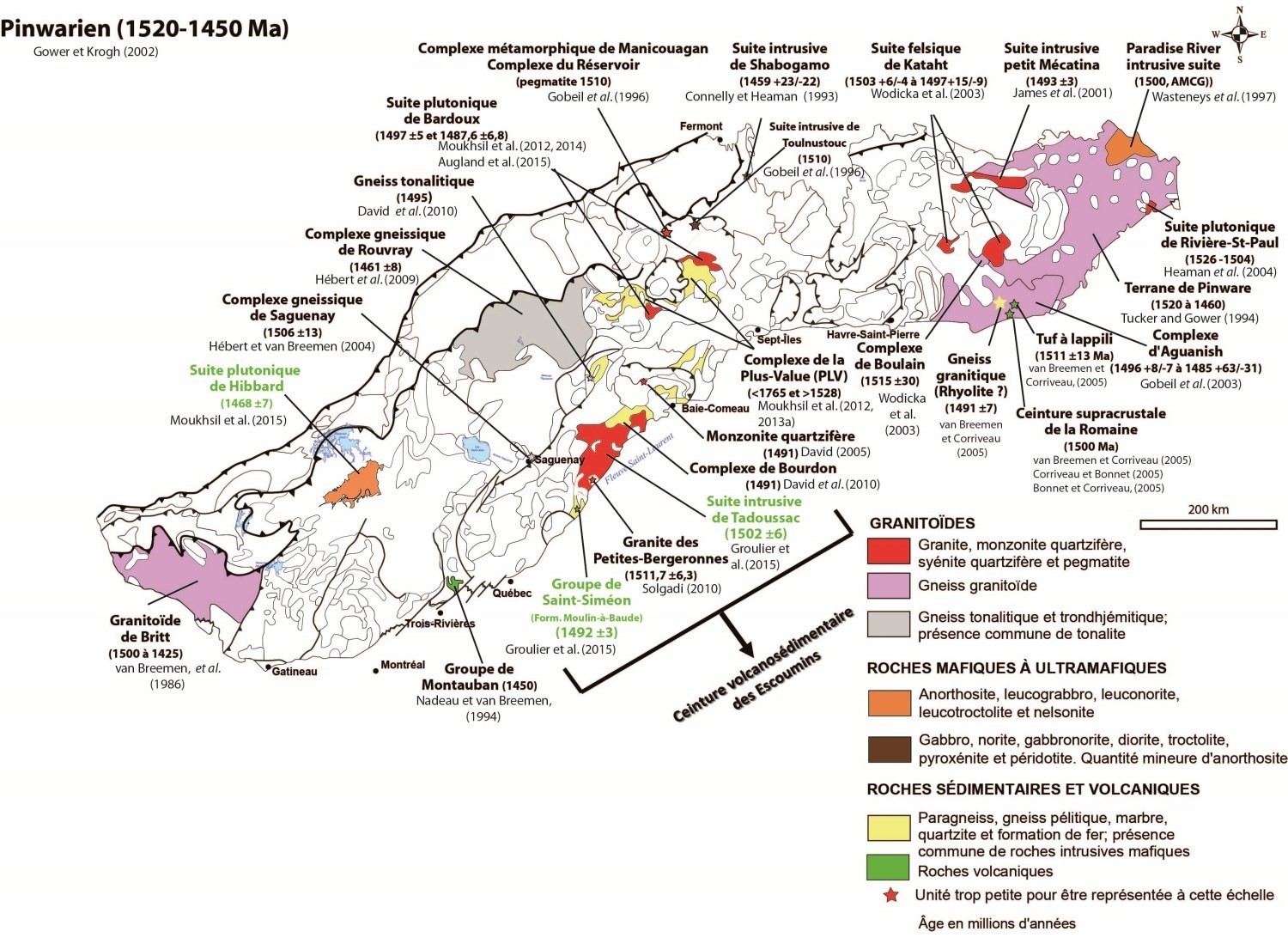
Pinwarian Orogenesis (1520-1450 Ma)
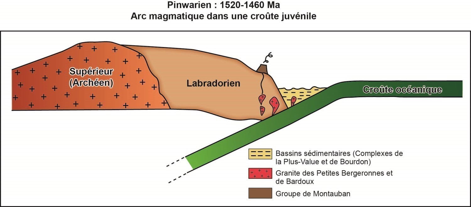
The Pinwarian Orogenesis covers a period of 70 Ma and extends throughout the Grenville Province. It is larger than the Labradorian and Wakamian events combined. Apart from a few Labradorian klippes, the Pinwarian is the bedrock of the Allochton and forms the base on which all rocks of the Grenville Province will form. The Pinwarian is interpreted as the result of continental margin arc magmatism that corresponds to a magmatism and sedimentation episode in the central part of Grenville, while it is predominantly magmatic elsewhere in Grenville (Quebec, Ontario and Labrador). It is one of the most important orogeneses (1.52-1.45 Ga) in the Grenville Province, first for its current east-west extent, and also for the large volume of plutonic rocks in that period.
Elsonian Event (1450-1230 Ma)
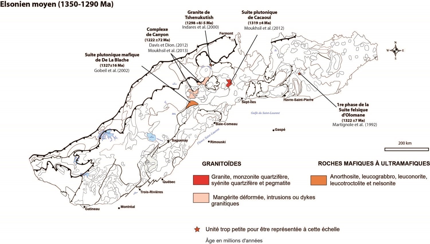
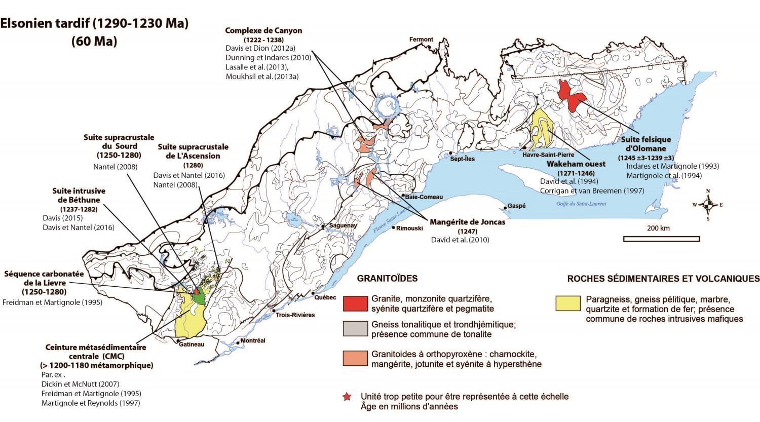
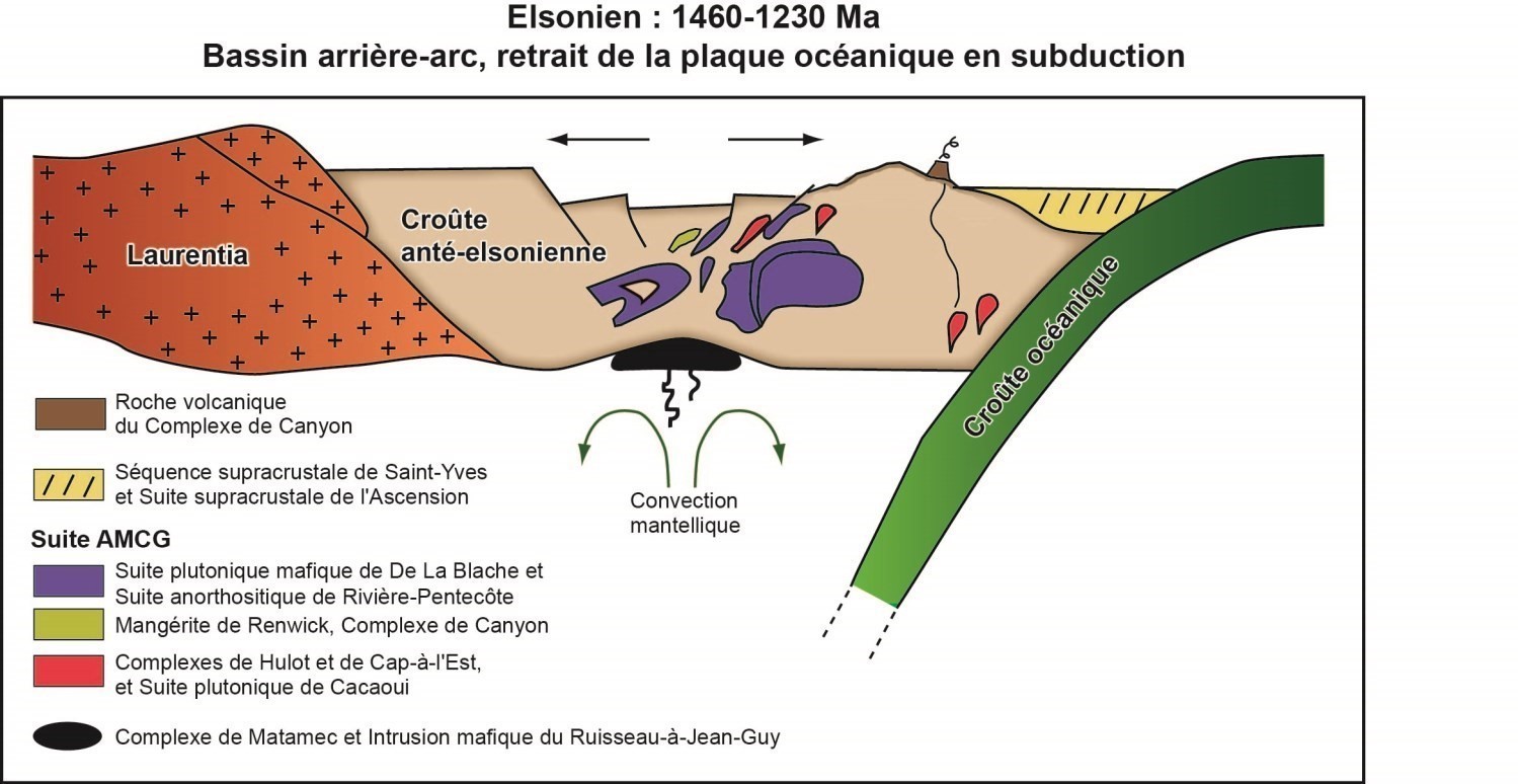
The Elsonian is the longest event in the Grenville orogenesis (230 Ma). According to Stockwell (1964), this is a geological episode characterized primarily by the intrusion of AMCG suites (anorthosite-mangerite-charnockite-granite) associated with troctolites, gabbros and quartz monzonites. According to Emslie (1978), the Elsonian is characterized by anorogenic magmatism in central Labrador between 1500 and 1400 Ma. Gower and Krogh (2002) defined the Elsonian as a tectonic event lasting 220 Ma, ranging from 1450 to 1230 Ma. They subdivided the Elsonian into three subperiods: Early Elsonian (1450-1350 Ma); Mid Elsonian (1350-1290 Ma); and Late Elsonian (1290-1230 Ma).
Elzevirian Orogenesis (1230-1180 Ma)
The Elzevirian Orogenesis was introduced for the 1300 to 1200 Ma range by Moore and Thompson (1980) in southwestern Grenville Province during the Flinton Group study in Ontario. Mclelland et al. (1996) had defined it between 1350 and 1180 Ma, whereas Rivers et al. (2012) attributed these rocks an age of 1245 to 1225 Ma. Although this orogenesis is not associated with the eastern part of Grenville, on the Labrador side, Gower and Krogh (2002) gave it an age range of 1230 to 1180 Ma. In the western part of Quebec Grenville, sediments of the Rabot Supracrustal Suite of the Caïn Domain returned a maximum age of 1217 Ma (David et al., 2009). It was determined that compression resumed with the Elzevirian accretional orogenesis and that during this period the Central Metasedimentary Belt accreted to the Laurentia continent to develop in an arc environment (Moore and Thompson, 1980; Gower and Krogh, 2002; Corriveau 2013). In the central part of Grenville, greenish mangerite of the Canyon Complex yielded an age of 1222 Ma with great uncertainty of ±72 Ma. The mangerite geochemistry, as well as that of granites associated with this complex, indicate setting between a volcanic arc environment and an intraplate environment. Due to the lack of geological data for this period in central Grenville, no geodynamic models were proposed.
Adirondian Event (1180-1080 Ma)
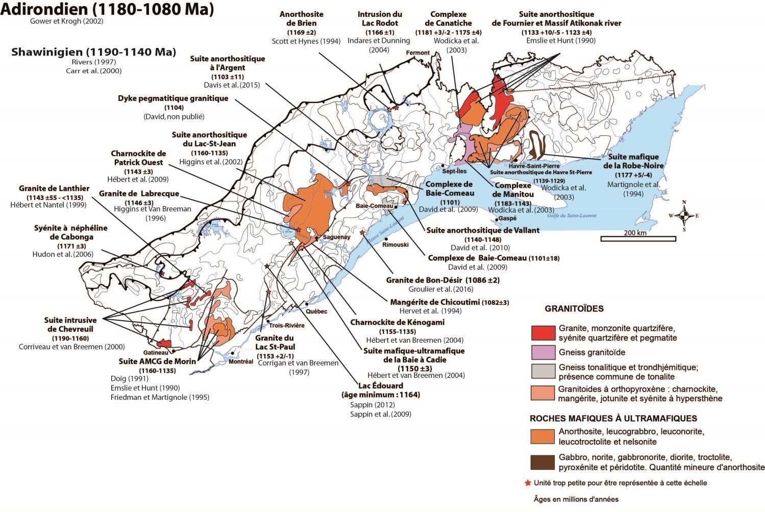
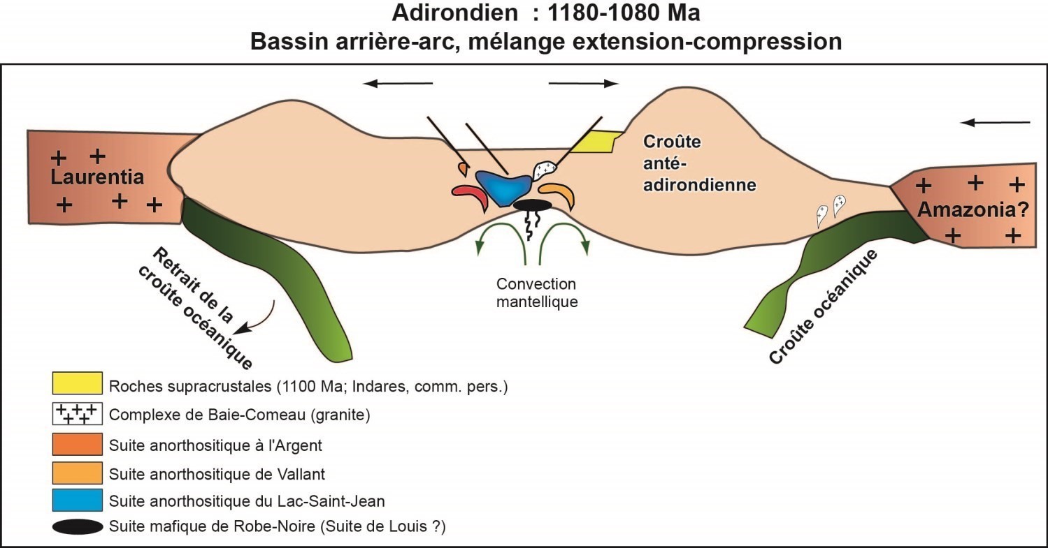
The Adirondian event spans a period of 100 Ma and is well documented in the Grenville Province. It is characterized, like the Elsonian, by instrusion of huge volumes of large-scale anorthositic suites throughout the Grenville Province in a back-arc basin during a crustal extension event. The presence of an arc component with emplacement of the Baie-Comeau Complex (1101 Ma) makes it possible to evoke, in terms of the model applicable to the central part of Grenville, a mix of extension and compression with the presence of a continental mass, probably from South America (Amazonia?).
Grenvillian Orogenesis (1080-985 Ma)
The Grenvillian orogenic event is characterized by large-scale magmatism and intense deformation, accompanied by prograde metamorphism. The Grenvillian Orogenesis lasts approximately 100 Ma, between 1080 and 985 Ma (Gower and Krogh, 2002) or between 1090 and 980 Ma (Rivers et al., 2012). However, all authors agree that the Grenville represents the deep root of an ancient mountain range comparable to the present Himalayas, and that it corresponds to a continent-to-continent collision range between an autochton domain (Archean and Proterozoic) and an allochton domain (Mesoproterozoic). According to Rivers (1997), Carr et al. (2000) and Rivers et al. (2012), there are two major orogenic phases (pulsations) of crustal shortening: Ottawa (~1090-1020 Ma) and Rigolet (1005-980 Ma). Prior to these two orogenic phases, the Shawinigan Orogenesis took place between 1190 and 1140 Ma (Rivers et al., 2012), partly contained in the Adirondian event of Gower and Krogh (2002). In the central part of Grenville, these pulsations would also have occurred, but at different ages than those described by Rivers (1997). Gower and Krogh (2002) subdivided the Grenvillian Orogenesis into three periods:
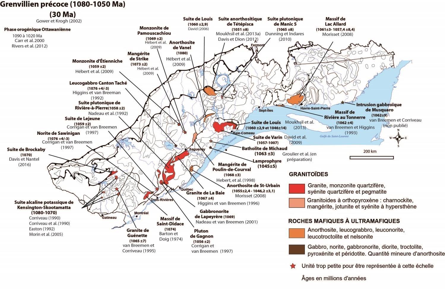
- Early Grenville (1080-1050 Ma);
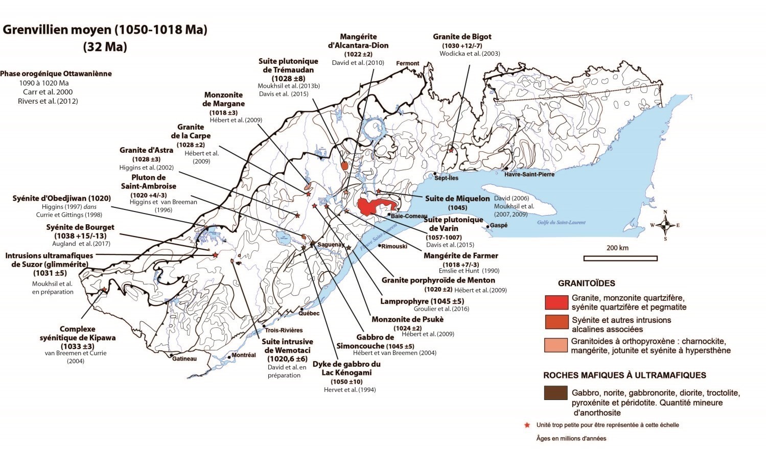
- Mid Grenville (1050-1018 Ma);
- Late Grenville (1018-985 Ma).
Early Grenville (1080-1050 Ma)
The Early Grenville, which lasts 30 Ma, is characterized by a plutonic magmatic activity with intrusion of large volumes of felsic magma. In the central part of Grenville, the Early Grenville is marked by intrusion of mafic magma (Tétépisca Anorthositic Suite, 1051 Ma) and the Louis Suite (gabbro and gabbronorite, 1060 Ma). Intrusion of all these volumes of mafic rocks indicates a crustal extension environment.
Mid Grenville (1050-1018 Ma)
The Mid Grenville covers a period of 32 Ma. It is characterized by magmatic activity throughout the Grenville Province. In the central part of Grenville, this episode corresponds to intrusion of the Trémaudan Plutonic Suite of (quartz syenite dated 1028 Ma). The geochemical signature of these K2O-rich rocks, of shoshonitic affinity and marked by a negative Nb anomaly, indicates cessation of subduction and emplacement during collision. The metamorphic peak age (granule facies) is different along the Grenville Province. In Central Grenville (Manicouagan region), it was established between 1080 and 1050 Ma (crust thickening; Dunning and Indares, 2010; Rivers et al., 2012 and references included). Moukhsil et al. (2009) defined a metamorphic peak at 1034 Ma in a quartzite in the Baie-Comeau region. The Mid Grenville is considered to be the pinnacle of the Grenville Orogenesis, since this period is characterized by the building of its mountain range.
Late Grenville (1018-985 Ma)
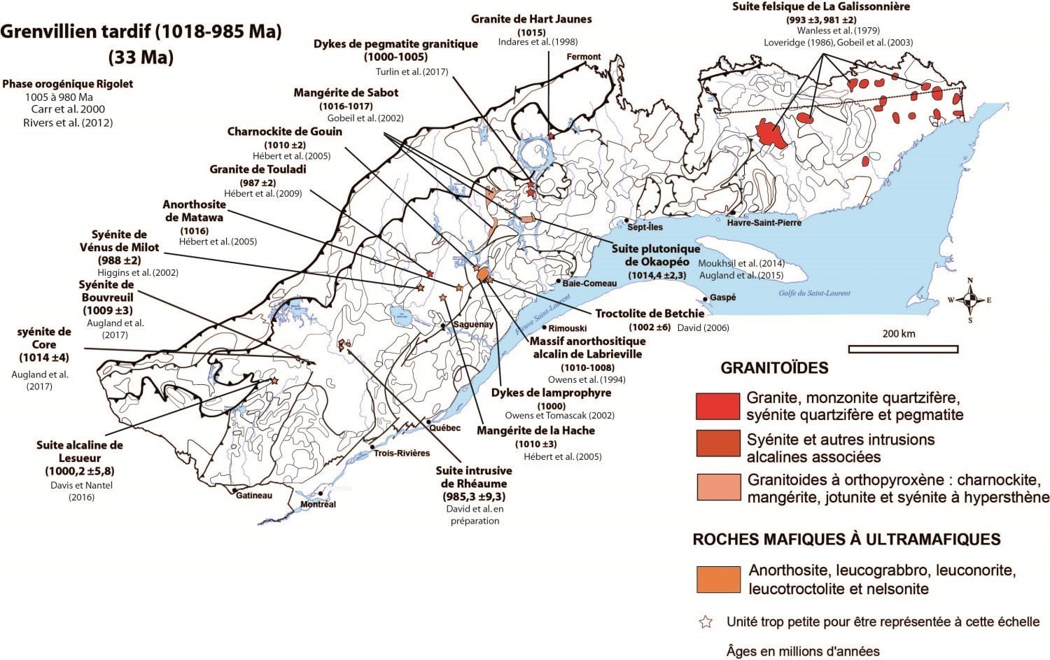
The Late Grenville covers a period of 33 Ma and is recognized throughout the Grenville Province. It is marked by intrusion of alkaline magma of felsic to intermediate, and mafic (anorthosite, troctolite) composition. In the central part, this period is characterized mainly by intrusion of intermediate magmas (mangerite; 1015-1017 Ma) in an anorogenic environment. The Late Grenville would therefore correspond to a context of crustal extension due to gravitarian collapse, with a loss of root due to the collapse of the crustal pile when cooled.
Post-Grenville (<985 Ma)
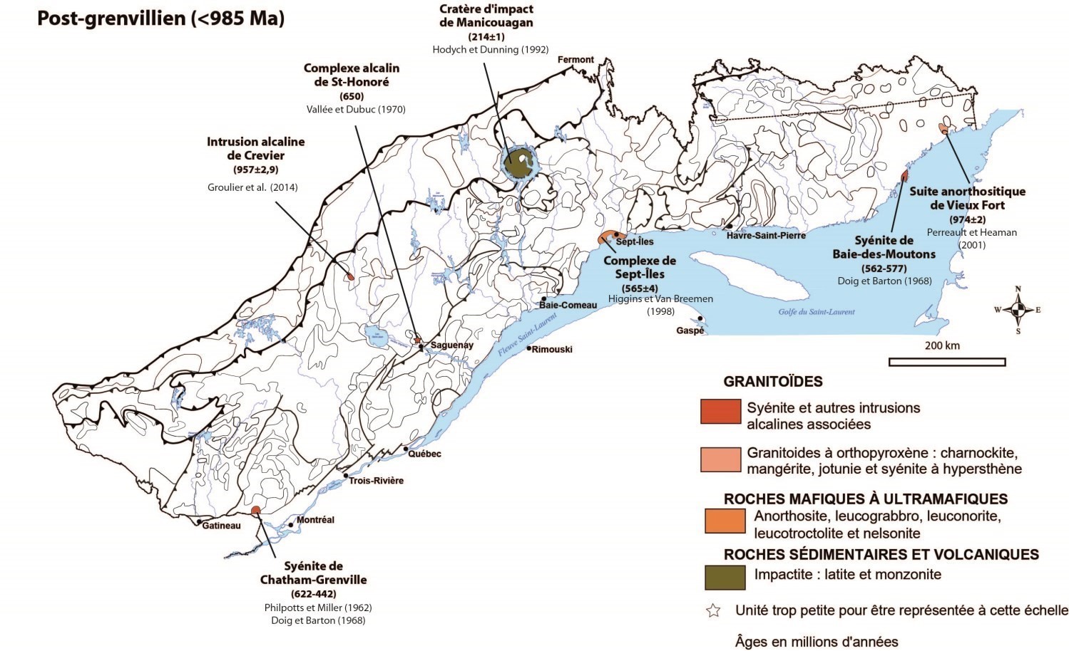
The Post-Grenville or Postgrenvillian corresponds to rocks younger than 985 Ma (Gower and Krogh, 2002). Three age groups are identified in the Grenville Province: 1) ages approaching those of the Late Grenville, ranging from 985 to 950 Ma; 2) younger ages ranging from 650 to 500 Ma; and 3) a Triassic age of 214 ±1 Ma. Ages of the first group imply that the late Grenvillian extension continued throughout the Grenville Province until around 950 Ma. The second age group consists mainly of alkaline rocks such as syenites and carbonatites. Higgins (1982) links emplacement of these intrusions to opening of the St. Lawrence Rift or the formation of the Iapetus Ocean. Finally, postgrenvillian rocks dated to 214 ±1 Ma correspond to rocks of the Manicouagan impact crater (Hodych and Dunning, 1992).
References
| Author(s) | Title | Year of Publication | Hyperlink (EXAMINE or Other) |
|---|---|---|---|
| AUGLAND, L. E. – MOUKHSIL, A. – SOLGADI, F. | Mantle influence of syn- to late Grenvillian alkaline magmatism in the Grenville Province: causes and implications. Canadian Journal of Earth Sciences; volume 54, pages 263-277. | 2017 | Source |
| AUGLAND, L. E. – MOUKHSIL, A. – SOLGADI, F. – INDARES, A. | Pinwarian to Grenvillian magmatic evolution in the central Grenville Province: new constraints from ID–TIMS U–Pb ages and coupled Lu–Hf S–MC–ICP–MS data. Canadian Journal of Earth Sciences; volume 52, pages 701-721. | 2015 | Source |
| BONNET, A.L. – CORRIVEAU, L. – LA FLÈCHE, M.R. | Chemical imprint of highly metamorphosed volcanic-hosted hydrothermal alterations in the La Romaine Supracrustal Belt, eastern Grenville Province, Québec. Canadian Journal of Earth Sciences; volume 42, pages 1783-1814. | 2005 | Source |
| CAMERON, K.L. – LOPEZ, L. – ORTEGA-GUTIÉRREZ, F. – SOLARI, L.A. – KEPPIE, J. – SCHULZE, C. | U-Pb geochronology and Pb isotopic compositions of leached feldspars: Constraints on the origin and evolution of Grenville rocks from eastern and southern Mexico. In: Proterozoic Tectonic Evolution of the Grenville Orogen in North America. Edited by Richard P. Tollo, James McLelland, Louise Corriveau and Mervin J. Bartholomew. Geological Society of America; volume 197, pages 755-771. | 2004 | Source |
| CARR, S.D. – EASTON, R.M. – JAMIESON, R.A. – CULSHAW, N.G. | Geologic transect across the Grenville Orogen of Ontario and New York. Canadian Journal of Earth Sciences; volume 37, pages 193-216. | 2000 | Source |
| COLLINS, W.H. | North shore of Lake Huron. Geological Survey of Canada; Memoir 143, 160 pages. | 1925 | Source |
| CONNELLY, J.N. – HEAMAN, L.M. | U-Pb geochronological constraints on the tectonic evolution of the Grenville Province, western Labrador. Precambrian Research; volume 63, pages 123–142. | 1993 | Source |
| CORRIGAN, D. | Mesoproterozoic evolution of the south-central Grenville Orogen, structural, metamorphic, and geochronologic constraints from the Mauricie transect. Carleton University; Ph. D Thesis, Carleton University, Ottawa, Ontario, 308 pages. | 1995 | Source |
| CORRIGAN, D. – VAN BREEMEN, O. | U-Pb age constraints for lithotectonic evolution of the Grenville Province along the Mauricie transect, Québec. Canadian Journal of Earth Science; volume 34, pages 299-316. | 1997 | Source |
| CORRIVEAU, L. | Pinwarian (1.5 Ga) volcanism and hydrothermal activity at the eastern margin of the Wakeham Group, Grenville Province, Québec. Canadian Journal of Earth Sciences; volume 42, pages 1749-1782. | 2005 | Source |
| DAVID, J. – MOUKHSIL, A. – DION, C. | Datations U-Pb effectuées dans la Province de Grenville en 2008-2009. Ministère des Ressources naturelles, Québec; RP 2010-10, 17 pages. | 2010 | RP 2010-10 |
| DAVID, J. – MOUKHSIL, A. – CLARK, T., HÉBERT, C., NANTEL, S. – DION, C. – SAPPIN, A. | Datations U-Pb effectuées dans les provinces de Grenville et de Churchill en 2006-2007. Ministère des Ressources naturelles, Québec; RP 2009-03, 32 pages. | 2009 | RP 2009-03 |
| DAVID, J. | Rapport préliminaire sur des travaux de géochronologie U-Pb, année 2004-2005. Ministère des Ressources naturelles et de la Faune du Québec; GM 62069, 31 pages. | 2005 | GM 62069 |
| DAVID, J. – MACHADO, N. – GARIÉPY, C. | Géochronologie U-Pb du territoire québécois, Province de Grenville et Origène appalachien. GEOTOP, Université du Québec à Montréal, cinquième rapport intérimaire, 2e partie, résultats analytiques des années 1993-1994. Ministère des Ressources naturelles, Québec; GM 59988, 27 pages. | 1994 | GM 59988 |
| DAVIDSON, A. | An overview of Grenville Province Geology, Canadian Shield; Chapter 3. In: Geology of the Precambrian Superior and Grenville Provinces and Precambrian Fossils in North America (S.B. Lucas and M.R. St-Onge, editors.). Geological Survey of Canada; No. 7, pages 205-270. | 1998 | Source |
| DAVIDSON, A. | A review of the Grenville orogen in its North American type area. Australian Geological Survey Organisation, Journal of Australian Geology and Geophysics; volume 16, pages 3-24. | 1995 | Source |
| DAVIS, D.W. – NANTEL, S. | Datations U-Pb dans la partie nord de la Ceinture centrale des métasédiments, Province de Grenville, région de Mont-Laurier. Ministère de l’Énergie et des Ressources naturelles, Québec; MB 2016-04, 52 pages. | 2016 | MB 2016-04 |
| DAVIS, D.W. – MOUKHSIL, A. – LAFRANCE, I. – HAMMOCHE, H. – GOUTIER, J. – PILOTE. – TALLA TAKAM, F. | Datations U-Pb dans les provinces du Supérieur, de Churchill et de Grenville effectuées au JSGL en 2012-2013. Ministère de l’Énergie et des Ressources naturelles, Québec; RP 2014-07, 56 pages. | 2015 | RP 2014-07 |
| DAVIS, D.W. – DION, C. | Datations LA-ICPMS d’échantillons recueillis en 2011-2012 par Géologie Québec. Ministère de l’Énergie et des Ressources naturelles, Québec; MB 2012-09, 49 pages. | 2012a | MB 2012-09 |
| DAVIS, D.W. – DION, C. | Datations ID-TIMS d’échantillons recueillis en 2011-2012 par Géologie Québec. Ministère de l’Énergie et des Ressources naturelles, Québec; MB 2012-07, 41 pages. | 2012b | MB 2012-07 |
| DERRY, D.R. | A tectonic map of Canada. Geological Association of Canada Proceedings; volume 3, pages 39-53. | 1950 | – |
| DICKIN, A.P. – MCNUTT, R.H. | The Central Metasedimentary Belt (Grenville Province) as a failed backarc rift zone: Nd isotopic evidence. Earth and Planetary Science Letters; volume 259, pages 97-106. | 2007 | Source |
| DICKIN, A.P. | Crustal formation in the Grenville Province: Nd isotope evidence. Canadian Journal of Earth Sciences; volume 37, pages 165-181. | 2000 | Source |
| DICKIN, A.P. – HIGGINS, M.D. | Sm/Nd evidence for a major 1.5 Ga crust-forming event in the Central Grenville Province. Geology; volume 20, pages 137-140. | 1992 | Source |
| DUNNING, G. – INDARES, A. | New insights on the 1.7-1.0 Ga crustal evolution of the central Grenville Province from the Manicouagan. Baie-Comeau transect. Precambrian Research; volume 180, pages 204-226. | 2010 | Source |
| FARIBAULT, E.R. – GWILLIM, J.C. – BARLOW, A.E. | Rapport sur la géologie et les ressources minières de la région de Chibougamau. Ministère de la colonisation, des mines et des pêcheries, Québec; AP 1912-01, 243 pages, 2 plans. | 1912 | AP 1912-01 |
| FENG, R. – KERRICH, R. – MCBRIDE, S. – FARRAR, E. | 40Ar/39Ar age constraints on the thermal history of the Archean Abitibi greenstone belt and the Pontiac Subprovince: implications for terrane collision, differential uplift, and overprinting of gold deposits, Canadian Journal of Earth Sciences; volume 29, pages 1389-1411. | 1992 | Source |
| FRIEDMAN, R. – MARTIGNOLE, J. | Mesoproterozoique sedimentation, magmatism, and metamorphic in the southern part of the Grenville Province (western Quebec): U-Pb geochronological constraints; Canadian Journal of Earth Sciences; volume 32, pages 2103-2114. | 1995 | Source |
| GOBEIL, A. – CLARK, T. – DAVID, J. | Nouvelles données géochronologiques U-Pb dans le Complexe métamorphique de Manicouagan. Dans : Projet Abitibi-Grenville. LITHOPROBE; Atelier 96, résumé des présentations, page 14. | 1996 | – |
| GOBEIL, A. – BRISEBOIS, D. – CLARK, T. – VERPAELST, P. – MADORE, L. – WODICKA, N. – CHEVÉ, S. | Géologie de la moyenne Côte-Nord, Dans : Géologie et ressources minérales de la partie est de la Province de Grenville; Daniel Brisebois et Thomas Clark coordonnateurs. Ministère des Ressources naturelles, Québec; DV 2002-03, pages 9-58. | 2003 | DV 2002-03 |
| GOBEIL, A – HÉBERT, C. – CLARK, T. – BEAUMIER, M. – PERREAULT, S. | Géologie de la région du lac De La Blache (22K/03 et 22K/04). Ministère des Ressources naturelles, Québec; RG 2002-01, 53 pages, 2 plans. | 2002 | RG 2002-01 |
| GOWER, C.F. | The evolution of the Grenville Province in eastern Labrador, Canada. In: Brewer, T.S., editor. Precambrian Crustal Evolution in the North Atlantic Region, Geological Society Special Publication; 112. Geological Society Publishing House, Bath, UK, pages 197-218. | 1996 | Source |
| GOWER, C.F. – KROGH, T.E. | A U-Pb geochronological review of the Proterozoic history of the eastern Grenville Province. Canadian Journal of Earth Sciences; volume 39, pages 795-829. | 2002 | Source |
| GOWER, C.F. – KAMO, S.L. – KROGH, T.E. | Indentor tectonism in the Grenville Province. Precambrian Research; volume 167, pages 201–212. | 2008 | Source |
| GROULIER, P.A. – INDARES, A. – DUNNING, G. – MOUKHSIL, A. | Géologie de la ceinture volcano-sédimentaire des Escoumins, Côte-Nord, Québec (rapport préliminaire). Ministère de l’Énergie et des Ressources naturelles du Québec; MB 2015-09, 82 pages. | 2015 | MB 2015-09 |
| HANMER, S. – CORRIGAN, D. – PEHRSSON, S. – NADEAU, L. | SW Grenville Province, Canada: The case against post- 1.4 Ga accretionary tectonics. Tectonophysics; volume 319, pages 33-51. | 2000 | Source |
| HEAMAN, L.M. – GOWER, C.F. – PERRERAULT, S. | The timing of Proterozoic magmatism in the Pinware terrane of southeast Labrador, easternmost Quebec and northwest Newfoundland. Canadian Journal of Earth Sciences; volume 41, pages 127-150. | 2004 | Source |
| HÉBERT, C. – VAN BREEMEN, O. | Mesoproterozoic basement, the Lac-St.-Jean anorthosite suite and younger Grenvillian intrusions in the Saguenay region (Québec): structural relationships and U-Pb geochronology. In: Proterozoic Tectonic Evolution of the Grenville Orogen in North America. Edited by Richard P. Tollo, James McLelland, Louise Corriveau and Mervin J. Bartholomew. Geological Society of America; volume 197, pages 65-81. | 2004 | Source |
| HÉBERT, C. – CADIEUX, A.M. – VAN BREEMEN, O. | Région du réservoir Pipmuacan, SNRC 22E, synthèse géologique. Ministère des Ressources naturelles et de la Faune, Québec; RG 2009-01, 56 pages, 1 plan. | 2009 | RG 2009-01 |
| HERVET M.D. – VAN BREEMEN, O. – HIGGINS, M. | U-Pb igneous crystallisation age of intrusive rocks near the southeastern margin of the Lac-St-jean Anorthosite Complex. Radiometric Age and Isotopic Studies: report 8. In Current Research Geological Survey of Canada; Paper 1994-F, pages 115-124. | 1994 | Source |
| HOFMANN, H.J. | Precambrian time units and nomenclature – the geon concept. Geology; volume 18, pages 340-341. | 1990 | Source |
| HYNES, A. – RIVERS, T. | Protracted continental collision – evidence from the Grenville Orogen. Canadian Journal of Earth Sciences; volume 47, pages 591-620. | 2010 | Source |
| HOFFMAN, P.F. | United plates of America, the birth of a craton: Early Proterozoic assembly and growth of Laurentia. Annual Reviews of Earth and Planetary Sciences; volume 16, pages 543-603. | 1988 | Source |
| HOFFMAN, P.F. | Precambrian geology and tectonic history of North America. In: The Geology of North America — An overview (A.W. Balby and A.R. Palmer, editors); Boulder, Colorado. Geological Society of America ; The geology of North America, volume A. | 1989 | Source |
| INDARES, A. – MOUKHSIL, A. | Geon 12 crustal extension in the central Grenville Province, implications for the orogenic architecture, and potential influence on the emplacement of anorthosites. Canadian Journal of Earth Sciences; volume 50, pages 955-966. | 2013 | Source |
| INDARES, A. – DUNNING, G. – COX, R. | Tectono-thermal evolution of deep crust in a Meso-proterozoic continental collision setting: the Manicouagan example. Canadian Journal of Earth Sciences 37; pages 325-340. | 2000 | Source |
| INDARES, A. – DUNNING, G.R. – COX, R.A. – GALE, D. – CONNELLY, J. | High P-T rocks from the base of thick continental crust in a Mesoproterozoic continental collision setting: the Manicouagan Imbricate Zone, eastern Grenville Province. Tectonics; 17, pages 426-440. | 1998 | Source |
| INDARES, A. – MARTIGNOLE, J. | Étude régionale du Supergroupe du Wakeham. Moyenne-Côte-Nord. Ministère de l’Énergie et des Ressources naturelles, Québec; MB 91-21, 74 pages, 3 plans. | 1993 | MB 91-21 |
| JAMES, D.T. – KAMO, S. – KROGH, T. – NADEAU, L. | Preliminary U-Pb geochronological data from mesoproterozoic rocks, Grenville province southern Labrador. Current research Newfoundland Department of mines and Energy; report 2001-1, pages 45-53. | 2001 | Source |
| JORDAN, S.L. – INDARES, A. – DUNNING, G. | Partial melting of metapelites in the Gagnon terrane below the high-pressure belt in the Manicouagan area (Grenville Province): pressure-temperature and U-Pb age constraints and implications. Canadian Journal of Earth Science; volume 43, pages 1309-1329. | 2006 | Source |
| KARLSTROM, K.E. – HARLAN, S.S. – WILLIAMS, M.L. – MCLELLAND, J. – GEISSMAN, J.W. – AHALL, K.-I. | Refining Rodinia: geologic evidence for the Australia-Western U.S. connection in the Proterozoic. GSA today; volume 9, pages 1-7. | 1999 | Source |
| KROGH, T.E. – HEAMAN, L. | Report on 1987-1988 contract geochronology Labrador, Royal Ontario Museum. Unpuplished report to Newfoundland Department of Mines and Energy; Open File No. Lab. 765, 102 pages. | 1988 | – |
| LASALLE, S. – FISHER, C.M. – INDARES, A. – DUNNING, G. | Contrasting types of Grenvillian granulite facies aluminous gneisses: Insights on protoliths and metamorphic events from zircon morphologies and ages. Precambrian Research; volume 228, pages 117-130. | 2013 | Source |
| LOGAN, W.E. – HUNT, T.S. | Esquisse géologique du Canada pour servir à l’intelligence de la carte géologique et de la collection des minéraux économiques envoyées à l’Exposition universelle de Paris, 1855. Commission géologique du Canada; Rapport séparé no. 395, 1855, 100 pages, 1 feuille. | 1855 | Source |
| LORENZ, H. – GEE, D.G. – LARIONOV, A.N. – MAJKA, J. | The Grenville–Sveconorwegian orogen in the high Arctic. Geological Magazine; volume 149, pages 875-891. | 2012 | Source |
| MACHADO, N. – DAVID, J. – GARIEPY, C. | Geochronologie U-Pb du territoire québécois. 1ère partie : les sous-provinces de l’Abitibi et du Pontiac. Ministère de l’Énergie et des Ressources naturelles, Québec; GM 66921, 21 pages. | 1992 | GM 66921 |
| MACHADO, N.– MARTIGNOLE, J. | First U-Pb age for magmatic zircon in anorthosite: the case of the Pentecôte intrusion in Québec. GAC-MAC 1988, Programme et résumés; 13, page A76. | 1988 | – |
| MADORE, L. – VERPAELST, P. – BRISEBOIS, D. – CHOINIÈRE, J. – DION, D.J. – DAVID, J. | Géologie de la région du Lac Cormier (12N/04). Ministère des Ressources naturelles du Québec; RG 97-08, 32 pages, 1 plan. | 1997a | RG 97-08 |
| MADORE, L. – VERPAELST, P. – DION, D.J. – CHOINIÈRE, J., HOCQ, M. – MARQUIS, R. – LEFEBVRE, D. – DAVID, J. | Géologie de la région du Lac Briend (12N/05). Ministère des Ressources naturelles, Québec; RG 96-05, 30 pages, 1 plan. | 1997b | RG 96-05 |
| MARTIGNOLE, J. – REYNOLDS, P. | 40Ar/39Ar thermochronology along a western Québec transect of the Grenville Province, Canada. Journal of Metamorphic Geology; volume 15, pages 283-296. | 1997 | Source |
| MARTIGNOLE, J. – MACHADO, N. – INDARES, A. | The Wakeham Terrane: a Mesoproterozoic terrestrial rift in the eastern part of the Grenville Province. Precambrian Research; volume 68, pages 291-306. | 1994 | Source |
| MOUKHSIL, A. – SOLGADI, F. | Géologie, potentiel minéral et cadre géodynamique des roches de la région du réservoir Daniel-Johnson (Manicouagan) partie centrale de la Province de Grenville. Ministère de l’Énergie et des Ressources naturelles, Québec; MM 2017-01, 307 pages, 1 plan. | 2018 | MM 2017-01 |
| MOUKHSIL, A. – SOLGADI, F. – BELKACIM, S. – ELBASBAS, A. – AUGLAND, L.E. | Géologie de la région du lac Okaopéo, Côte-Nord. Ministère de l’Énergie et des Ressources naturelles, Québec; RG 2014-03, 34 pages, 1 plan. | 2017 | RG 2014-03 |
| MOUKHSIL, A. – SOLGADI, F. – BELKACIM, S. – AUGLAND, L.E. – DAVID, J. | Géologie de la région de Parent Haut-Saint-Maurice (partie ouest du Grenville). Ministère de l’Énergie et des Ressources naturelles, Québec; RG 2015-04, 62 pages, 1 plan. | 2015 | RG 2015-04 |
| MOUKHSIL, A. – SOLGADI, F. – CLARK, T. – BLOUIN, S. – INDARES, A. – DAVIS, D.W. | Géologie du nord-ouest de la région du barrage Daniel-Johnson (Manic 5), Côte-Nord (22K14, 22K15, 22K16, 22N02 et 22N03). Ministère des Ressources naturelles, Québec; RG 2013-01, 44 pages, 1 plan. | 2013a | RG 2013-01 |
| MOUKHSIL, A. – SOLGADI, F. – INDARES, A. – BELKACIM. S. | Géologie de la région septentrionale du réservoir aux Outardes 4, Côte-Nord. Ministère des Ressources naturelles, Québec; RG 2013-03, 31 pages, 1 plan. | 2013b | RG 2013-03 |
| MOUKHSIL, A. – SOLGADI, F. – LACOSTE, P. – GAGNON, M. – DAVIS, J. | Géologie de la région du lac du Milieu (SNRC 22O03, 22O04, 22O06, 22J13 et 22J14). Ministère des Ressources naturelles et de la Faune, Québec; RG 2012-01, 33 pages, 1 plan. | 2012 | RG 2012-01 |
| MOUKHSIL, A. – LACOSTE, P. – SOLGADI, F. – DAVID, J. | Géologie de la partie orientale de la région de Baie-Comeau (partie ouest de 22G). Ministère des Ressources naturelles et de la Faune, Québec; RG 2011-02, 33 pages, 1 plan. | 2011 | RG 2011-02 |
| NADEAU, L., VAN – BREEMEN, O. | Do the 1,45-1,39 Montauban Group and La Bostonnais Complex constitute a Grenvillian accreted terrane? In: Programme with Abstract. Geological Association of Canada/Mineralogical Association of Canada; 19, page A81. | 1994 | – |
| NANTEL, S. | Géologie et aperçu de la géochronologie et des indices métalliques découverts entre 1996 et 2007 dans la partie nord de la Ceinture centrale des métasédiments, Province de Grenville, région de Mont-Laurier. Ministère des Ressources naturelles, Québec; DV 2008-04, 20 pages, 1 plan. | 2008 | DV 2008-04 |
| PERREAULT, S. – HEAMAN, L. | Géologie et géochronologie de la Basse-Côte-Nord (entre Chevery et Blanc-Sablon) dans la province géologique de Grenville. Dans : Géologie et ressources minérales de la partie est de la Province de Grenville; Daniel Brisebois et Thomas Clark, coordonnateurs. Ministère des Ressources naturelles, Québec; DV 2002-03, pages 119-146. | 2003 | DV 2002-03 |
| RIVERS, T. | Lithotectonic element of the Grenville province: review and tectonic implications. Precambrian Research; volume 86, pages 117-154. | 1997 | Source |
| RIVERS, T. – CULSHAW, N. – HYNES, A. – INDARES, A. – JAMIESON, R. – MARTIGNOLE, J. | The Grenville orogen – A post-LITHOPROBE perspective. Chapter 3. In: Tectonic Styles in Canada: The LITHOPROBE Perspective. Edited by J.A. Percival, F.A. Cook and R.M. Clowes. Geological Association of Canada; Special Paper 49, pages 97-236. | 2012 | – |
| RIVERS, T. – CORRIGAN, D. | Convergent margin on southeastern Laurentia during the Mesoproterozoic: tectonic implications. Canadian Journal of Earth Sciences; volume 37, pages 359-383. | 2000 | Source |
| RIVERS, T. – MARTIGNOLE, J. – GOWER, C.F. – DAVIDSON, A. | New tectonics division of the Grenville Province, southeast Canadian Shield. Tectonics; volume 8, pages 63-84. | 1989 | Source |
| SOLGADI, F. | Origine et développement de litages dans des roches de composition granitique. Thèse de doctorat, Université du Québec à Chicoutimi; 458 pages. | 2010 | Source |
| STOCKWELL, C.H. | Tectonic map of Canada. Summary of Activities: Office and Laboratory, 1962, Commission géologique du Canada; Études no. 63-2, 1963, page 72. | 1962 | Source |
| STOCKWELL, C.H. | Age determinations and geological studies. Part II: Geological studies; Fourth Report on Structural Provinces, Orogenies, and Time-Classification of Rocks of the Canadian Precambrian Shield. Geological Survey of Canada; Paper 64-17, 35 pages, 2 plans. | 1964 | Source |
| STOCKWELL, C.H. | Tectonic map of Canada. Commission géologique du Canada; Carte série « A » 1251A, 1969, 1 feuille. | 1969 | Source |
| STOCKWELL, C.H. | Proposals for time classification and correlation of precambrian rocks and events in Canada and adjacent areas of the Canadian Shield. Part 1: A time classification of precambrian rocks and events. Geological Survey of Canada; paper 80-19, 135 pages. | 1982 | Source |
| TUCKER, R.D. – GOWER, C.F. | A U-Pb geochronological framework for the Pinware terrane, Grenville Province, southeast Labrador, Journal of Geology; volume 102, pages 67-78. | 1994 | Source |
| VAN BREEMEN, O.– CORRIVEAU, L. | U–Pb age constraints on the arenaceous Wakeham Group from detrital zircons and from late stage pyroclastic rocks; link to the Pinwarian orogeny in the eastern Grenville Province. Canadian Journal of Earth Sciences; volume 42, pages 1677-1697. | 2005 | Source |
| VAN BREEMEN, O. – CURRIE, K.L. | Geology and U-Pb geochronology of the Kipawa Syenite Complex. A thrust related alkaline pluton and adjacent rocks in the Grenville Province of western Quebec, Canadian Journal of Earth Sciences; volume 41, pages 431-455. | 2004 | Source |
| VAN BREEMEN, O. – DAVIDSON, A. – LOVERIDGE, W.D. – SULLIVAN, R.D. | U-Pb zircon geochronology of Grenvillian tectonites, granulites and igneous precursors, Parry Sound, Ontario. In The Grenville Province. Edited by J.M. Moore, A. Davidson, and A.J. Baer. Geological Association of Canada; Special Paper 31, pages 191–207. | 1986 | Source |
| VERPAELST, P. – MADORE, L. – CHOINIÈRE, J. – DION, D. J. – LÉPINE, I. – DAVID, J. – HOCQ, M. – LEFEBVRE, D. – PERREAULT, S. | Géologie de la région du lac Le Doré (SNRC 12N/06). Ministère des Ressources naturelles, Québec; RG 96-02, 31 pages, 1 plan. | 1997 | RG 96-02 |
| WILSON, J.T. | Some major structures of the Canadian Shield. Canadian Institute of Mining and Metallurgy; Transactions, volume 52, pages 142-231 | 1949 | – |
| WILSON, M.E. | The Grenville Precambrian Subprovince. Journal of Geology; volume 33, pages 389-407. | 1925 | – |
| WINDER, C.G. | Logan, sir William Edmond. dans Dictionnaire biographique du Canada; vol. 10, Université Laval/University of Toronto, 2003. | 1972 | – |
| WINDLEY, B.F. | Comparative tectonics of the western Grenville and the western Himalaya. In: The Grenville Province (J.M. Moore, A. Davidson and A.J. Baer, editors), St. John’s, NF, Canada; GAC Special Paper 31, pages 341-348. | 1986 | – |
| WODICKA, N. – DAVID, J. – PARENT, M. – GOBEIL, A. – VERPAELST, P. | Geochronologie U-Pb et Pb-Pb de la région de Sept-Îles-Natashquan, Province de Grenville, moyenne Côte-Nord. In : Synthèse géologique et métallogénique de la partie est de la Province de Grenville. Édité par : D. Brisebois and T. Clark. Ministère des Ressources naturelles, de la Faune et des Parcs, Québec; DV 2002-03, pages 59–118. | 2003 | DV 2002-03 |
| WYNNE-EDWARDS, H.R. | The Grenville province. In: Variations in Tectonic Styles in Canada (R.A. Price and J.W. Douglas, editors). Geological Association of Canada; special paper 2, pages 263-334. | 1972 | – |


