

Last modified:
Background
The first descriptions of the Nemiscau Subprovince and the basis for its current limit were drawn from the work of Card and Ciesielski (1986). These authors used the name “Nemiscau River Subprovince” in reference to the Nemiscau River in the Eeyou Istchee James Bay Territory in Quebec. This name was later used by Card (1990) in its revision of the Superior Province. In Quebec, the term “Nemiscau Subprovince” has been adopted and widely used by the majority of authors who have done work there. Since the first descriptions by Card and Ciesielski (1986), the boundaries of the Nemiscau Subprovince have become clearer thanks in part to surveys and geological surveys carried out by the Ministère and its partners.
The majority of geological surveys in the Nemiscau Subprovince were conducted in the 1960s and 1970s at scales of 1:50,000 (Remick and Ahmedali, 1974), 1:63,360 (Remick et al., 1963; Remick, 1963; Gillain, 1964, 1965; Valiquette, 1963, 1964, 1975; Wallach, 1973; Ciesielski, 1975), 1:100,000 (Dubé, 1975, 1977, 1978; Franconi, 1975, 1976, 1978), 1:126,720 (Bourne, 1972) and 1:250,000 (Dubé et al., 1976). In the 2000s, 1:50,000 scale geological surveys were conducted along the Eastmain and Opinaca rivers near the northern boundary between the Nemiscau and La Grande subprovinces (Moukhsil, 2000; Moukhsil et al., 2001; and Moukhsil and Legault, 2002). This work has improved the geological knowledge of the Lower Eastmain River Volcano-Sedimentary Belt (LERVB; Hocq, 1994) and refined the stratigraphy of the region initiated by Franconi in 1978. More recently, the 1:50,000 scale mapping work conducted by Bandyayera and Daoudene (2017, 2018, 2019) in the Nemiscau and Champion lakes region has helped to identify, for these areas, the boundaries between the Nemiscau Subprovince and the Opatica and La Grande subprovinces.
Unlike Card and Ciesielski (1986), Hocq (1994) assigned the Lac Champion Terrain (LCT) to the Nemiscau Subprovince, and the Lac des Montagnes Band (LMB) to the Opatica Subprovince. Recent geological mapping suggests that the LCT is a southern extension of the La Grande Subprovince and that LMB belongs to Nemiscau (Bandyayera and Daoudene, 2017).
Description
The Nemiscau Subprovince is a subdivision of the Superior Province. It is located in the eastern part of the Eeyou Istchee James Bay Territory in Quebec between the Opatica Subprovince in the south and Opinaca and La Grande in the north. The northern boundary of the Nemiscau Subprovince follows the contacts of the LERVB. In its southern part, it runs along the boundaries of the Rupert Complex and those of a narrow volcano-sedimentary belt oriented NE-SW in the west and E-W in the east, known as the Colomb-Chaboullié Belt. It is regionally interpreted as the southern boundary of the Nemiscau (Bandyayera and Daoudene, 2017). To the east, the Nemiscau Subprovince is connected to the metasedimentary Opinaca Subprovince by a narrow band of volcanic and sedimentary rocks, the Lac des Montagnes Band (LMB). To the west, it is limited by the Hudson Bay Shelf and the James Bay Gulf.
Geology
The Nemiscau Subprovince consists mainly of metasedimentary rocks variably migmatitized, as well as low-proportion volcanic belts, tonalitic,granitic to granodioritic intrusions and large pegmatite masses (Card and Ciesielski, 1986; Hocq, 1994; Ciesielski, 1998). All metasedimentary rocks have been assigned to the Rupert Complex (Bandyayera and Daoudene, 2018). This complex includes more or less migmatitized paragneiss, metatexites and diatexites after paragneiss and locally granitic pegmatites (Remick, 1963; Gillain, 1963; Valiquette, 1975; Bandyayera and Daoudene, 2018b). Diatexites make up 60% of the area of the Rupert Complex. In the northern part, Nemiscau consists of paragneiss belonging to the Auclair Formation corresponding to the summit of the Eastmain Group volcano-sedimentary sequence. The Auclair Formation consists of sandstone or pelites containing clay beds and feldspathic wacke. These sediments are considered the sediment equivalent of the Laguiche Complex (Simard and Gosselin, 1998; Moukhsil and Doucet, 1999).
In the south, paragneiss of the Rupert Complex unconformably lie on or are in fault contact with the Colomb-Chaboullié Belt units. This narrow belt of volcano-sedimentary rocks marks the contact zone between the Nemiscau and Opatica subprovinces. The boundary between Nemiscau and Opatica is manifested by the presence of the Lac Coulomb Shear Zone, located between rocks of the Colomb-Chaboullié Belt and those of Opatica. The Colomb-Chaboullié Belt consists mainly of mafic and intermediate volcanic rocks, felsic to intermediate volcanoclastics, mafic and ultramafic sills and, in lesser proportions, iron formations, wackes and conglomerates assigned to the Colomb-Chaboullié Group (Bandyayera and Daoudene, 2018).
To the north, the Rivière Rupert Shear Zone, located between the Lac des Montagnes Band (LMB) and the Champion Complex, marks the boundary between Nemiscau and La Grande. The Champion Complex forms the southern extension of La Grande, while volcano-sedimentary units of the LMB, assigned to the Lac des Montagnes Group, are part of Nemiscau (Hocq, 1994; Bandyayera and Daoudene, 2017, 2018). The Lac des Montagnes Group is composed up of basalt, amphibolite, felsic and intermediate volcanoclastics, iron formations and mafic and ultramafic intrusions. In addition, contact between the Lac des Montagnes Group and the Rupert Complex is generally sheared off and could represent an old discordance.
Finally, the Nemiscau units are cut by three swarms of diabase dykes, the NW-SE-oriented Mistassini Dyke Swarm, the N-S-oriented Matachewan Dyke Swarm and the NE-SW-oriented Senneterre Dykes (Bandyayera and Daoudene, 2018).
The geology of the Nemiscau Subprovince differs from that of the Opinaca because it contains a large volcanic component, as well as bands of granulite derived from the melting of tonalite, diorite, amphibolite and paragneiss units. The 1:50,000-scale geological surveys of the Mid and Lower Eastmain (Moukhsil and Doucet, 1999; Moukhsil, 2000; Moukhsil et al., 2001; Moukhsil and Legault, 2002) show that the Nemiscau and Opinaca subprovinces are in stratigraphic contact with the La Grande Subprovince. This indicates that Opinaca and Nemiscau do not represent allochtonous metasediments relative to La Grande rocks (Moukhsil and Doucet, 1999; Goutier et al., 1999).
The Nemiscau's deformation style is described as polyphased (Hocq, 1994; Bandyayera and Daoudene, 2019). Metamorphism is usually in the mid amphibolite facies and increases to the granulites facies towards the centre of the basin (Gauthier et al., 2007). According to Bandyayera and Daoudene (2018), the presence of metatexites and diatexites derived from partial melting of volcano-sedimentary rocks of Nemiscau (Rupert Complex and Lac des Montagnes Group) indicates that these rocks have reached the upper amphibolite facies. In the southern part of the region, kilometric units of diatexite locally contain orthopyroxene, indicating that these rocks have reached the granulite facies.
Geological Evolution
The Nemiscau Subprovince is one of the metasedimentary assemblages with the Quetico, English River, Pontiac and Opinaca subprovinces that make up the Superior Province. It corresponds to the remains of a large sedimentary basin that would have formed just before 2700 Ma. The deposition age of the metasedimentary assemblage is estimated between 2698 and 2688 Ma (Percival et al., 1992). The dating of a granitic intrusion cutting metasedimentary rocks also indicates a minimum sedimentation age of 2672 ±2 Ma (Davis et al., 1995).
The linearity of the Quetico and English River metasedimentary belts observed on the Ontario side suggests that the Nemiscau and Opinaca basins are an extension of either of these belts. According to Card (1990), the eastern extension of the English River Subprovince could consist of the Nemiscau and Opinaca sedimentary basins on the Quebec side. It is also possible that the Nemiscau and Opinaca basins correspond more closely to the Quetico Basin extension. According to some studies, the Quetico Subprovince would be an accretionary prism (Card, 1990; Williams, 1986, 1990; Percival, 1989; Percival and Williams, 1989; Devaney and Williams, 1989). Because the petrological and geochemical characteristics of the Quetico Basin are similar to those of the Nemiscau and Opinaca basins (Doyon 2004), it is possible that these three basins represent one and the same large accretionary prism. However, the degree of metamorphism has been shown to increase from the Quetico basin to the Opinaca basin. According to Guernina and Sawyer (2003), as well as Percival (1989), the increase in eastward metamorphism was the result of crust uplift and could account for variations in metamorphism, deformation and erosion in all three basins.
In their study of the Mid and Lower Eastmain Greenstone Belt (MLEGB), Moukhsil et al. (2003) proposed different volcanic construction stages of the MLEGB in a geodynamic model. The final stage of this model is characterized by the absence of volcanic activity and a period of sedimentation in large basins such as the Nemiscau, Opinaca and Quetico basins. According to this model:
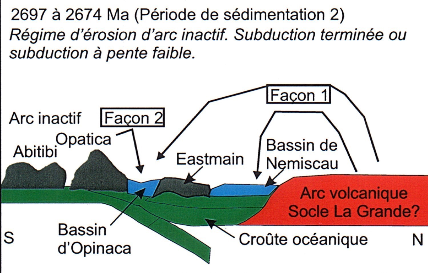
Between 2697 and 2674 Ma, there is erosion of volcano-plutonic assemblages, including an older continental crust probably located further north, as evidenced by the presence of old detrital zircons in paragneiss. The source of sediments in the Nemiscau Basin would be the erosion of a northern continent (La Grande SubProvince). Sediments in the Opinaca Basin could have had the same source or come from the Opatica Subprovince to the south. During this period, there was a collision between the Opatica Subprovince, which is already attached to the Abitibi Subprovince, and those of Nemiscau and Opinaca.
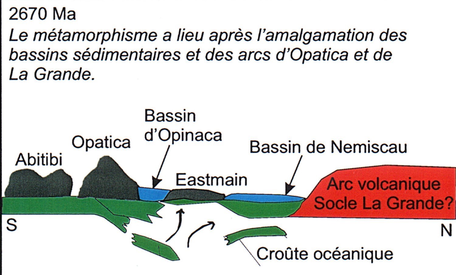
After 2670 Ma, regional metamorphism of high temperature and low pressure affects the Nemiscau and Opinaca basins. A break in the lithosphere would have allowed the rise of hot material at the base of the crust to produce deep, partial melting metamorphism.
However, the back-arc basin model proposed by Moukhsil et al. (2003) is questionable because of certain characteristics observed in the Quetico, Nemiscau and Opinaca basins (Doyon, 2004). Field observations indicate that these basins consist of complex folds involving compression deformation (Williams, 1990; Percival, 1989; Devaney and Williams, 1989), whereas a back-arc basin model involves an extensional regime (Percival, 1989). In the event that the back-arc basin model is plausible, this large basin (Quetico, Nemiscau and Opinaca) would span more than 2,000 km.
References
| Author(s) | Title | Year of Publication | Hyperlink (EXAMINE or Other) |
|---|---|---|---|
| BANDYAYERA, D. – DAOUDENE, Y. | Géologie de la région du lac Rodayer (SNRC 32K13-32K14-32N03 et 32N04-SE). Ministère de l’Énergie et des Ressources naturelles, Québec; RG 2017-01, 60 pages. | 2017 | RG 2017-01 |
| BANDYAYERA, D. – DAOUDENE, Y. | Géologie de la région du lac Nemiscau, secteur ouest de la rivière Rupert (SNRC 32N06, 32N07 et 32N11). | 2019 | RG 2018-03 |
| BANDYAYERA, D. – DAOUDENE, Y. | Géologie de la région du lac Champion, sous-provinces de La Grande et de Nemiscau, à l’est de Waskaganish, Municipalité Eeyou Istchee Baie-James, Québec, Canada. Ministère de l'Énergie et des Ressources naturelles, Québec. | 2018 | Bulletin géologiQUE |
| BOURNE, J.H. | Geology of the Mesgouez lake area, Abitibi, Mistassini and New Quebec Territories. Ministère de l’Énergie et des Ressources, Québec; DP 110, 14 pages, 1 plan. | 1972 | DP 110 |
| CARD, K.D. | A review of the Superior Province of the Canadian Shield, a product of Archean accretion. Precambrian Research; volume 48, pages 99-156. | 1990 | Source |
| CARD, K.D. – CIESIELSKI, A. | Subdivisions of the Superior Province of the Canadian Shield. Geoscience Canada; volume 13, pages 5-13. | 1986 | Source |
| CIESIELSKI, A. | Les migmatites du lac Giffard (comté d'Abitibi-Est). Ministère des Richesses naturelles, Québec; DP 302, 14 pages, 1 plan. | 1975 | DP 302 |
| CIESIELSKI, A. | Compilation géologique de la partie orientale de la Province du Supérieur (Québec). Commission géologique du Canada; Dossier Public 3580. Scale 1/1 000 000. | 1998 | Source |
| DAVIS, W.J. – MACHADO, N. – GARIÉPY, C. – SAWYER, E.W. – BENN, K. | U-Pb geochronology of the Opatica tonalite-gneiss belt and its relationship to the Abitibi greenstone belt, Superior Province, Quebec. Canadian Journal of Earth Sciences; volume 32, pages 113-127. | 1995 | Source |
| DEVANEY, J.R. – WILLIAMS, H.R. | Evolution of an Archean subprovince boundary: a sedimentological and structural study of part of the Wabigoon-Quetico boundary in northern Ontario. Canadian Journal of Earth Sciences, 26:1013-1026. | 1989 | Source |
| DOYON, J. | Comparaison de la composition des roches métasédimentaires archéennes dans les bassins de la Province du Supérieur; une étude géochimique et statistique. Université du Québec à Chicoutimi; mémoire de maîtrise, 214 pages. | 2004 | Source |
| DUBÉ, C. | Rapport préliminaire de la région du lac Béchard, territoire de Mistassini. Ministère des Richesses naturelles, Québec; DP 340, 12 pages, 1 plan. | 1975 | DP 340 |
| DUBÉ, C. – FRANCONI, A. – HOCQ, M. – REMICK, J.H. – SHARMA, K.N.M. – AVRAMTCHEV, L. – DUCROT, C. | Compilation géologique du territoire de la baie de James. Ministère des Richesses naturelles, Québec; DP 358, 8 pages, 18 plans. | 1976 | DP 358 |
| DUBÉ, C.Y. | Région des rivières Rupert et Marte, territoire de Mistassini. Ministère des Richesses naturelles, Québec; DPV 445, 12 pages, 1 plan. | 1977 | DPV 445 |
| DUBÉ, C.Y. | Région des lacs Champion, Tésécau et de la Rivière Rupert, Territoires de Mistassini et d’Abitibi. Ministère des Richesses naturelles, Québec; DPV 585, 36 pages, 2 plans. | 1978 | DPV 585 |
| FRANCONI, A. | Rapport géologique préliminaire sur la région de la rivière Eastmain inférieure, territoires de Mistassini et du Nouveau-Québec. Ministère des Richesses naturelles, Québec; DP 329, 40 pages, 1 plan. | 1975 | DP 329 |
| FRANCONI, A. | Géologie de la partie est de la bande volcanosédimentaire de la rivière Eastmain inférieure, territoires de Mistassini et du Nouveau-Québec. Ministère des Richesses naturelles, Québec; DPV 574, 24 pages, 2 plans. | 1976 | DPV 450 |
| FRANCONI, A. | La bande volcanosédimentaire de la rivière Eastmain inférieure, ouest de la longitude 76° 15ˈ. Ministère des Richesses naturelles, Québec; DPV 574, 186 pages, 2 plans. | 1978 | DPV 574 |
| GILLAIN, P.R. | Rapport géologique sur la région du lac Naquiperdu, Territoires de Mistassini et d’Abitibi. Ministère des Richesses naturelles, Québec; DP 178, 40 pages, 1 carte (échelle 1/31 680). | 1964 | DP 178 |
| GILLAIN, P.R. | Géologie de la région du lac Naquiperdu, Territoires des Mistassini et d’Abitibi. Ministère des Richesses naturelles, Québec; RP 525, 15 pages, 1 carte (échelle 1/63 360). | 1965 | RP 525 |
| GAUTHIER, M. – TRÉPANIER, S. – GARDOLL, S. | Metamorphic Gradient: A Regional-Scale Area Selection Criterion for Gold in the Northeastern Superior Province, Eastern Canadian Shield. SEG newsletter; April 2007, Number 69. | 2007 | - |
| GOUTIER, J. – MOUKHSIL, A. – DOUCET, P. – OUELLET, M.C. –DION, C. | Nature du contact entre les sous-provinces archéennes de La Grande et d’Opinaca au Québec : Zone tectonique ou contact stratigraphique? Programme et Résumé GAC/MAC 1999, page 71. | 1999 | - |
| GUERNINA, S. – SAWYER, E.W. | Large-scale melt depletion in granulite terranes: an example from the Archean Ashuanipi Subprovince of Quebec. Journal of Metamorphic Geology; 21: 181-201. | 2003 | Source |
| HOCQ, M. | Géologie du Québec, les publications du Québec, Québec. Ministère des Ressources naturelles; MM 94-01, 172 pages. | 1994 | MM 94-01 |
| MOUKHSIL, A. | Géologie de la région des lacs Pivert, Anatacau, Kauputauchechun et Wapamisk (SNRC 33C/01, 33C/02, 33C/07 et 33C/08). Ministère des Ressources Naturelles, Québec; RG 2000-04, 49 pages, 4 plans. | 2000 | RG 2000-04 |
| MOUKHSIL, A. | Synthèse géologique et métallogénique de la ceinture de roches vertes de la Moyenne et de la Basse-Eastmain (Baie-James). Ministère des Ressources Naturelles, de la Faune et des Parcs, Québec; ET 2002-06, 57 pages, 1 plan. | 2002 | ET 2002-06 |
| MOUKHSIL, A. – VOICU, G. – DION, C. – DAVID, J. – DAVIS, D.W. – PARENT, M | Géologie de la région de la Basse-Eastmain centrale (33C/03, 33C/04, 33C/05 et 33C06). Ministère des Ressources Naturelles, Québec; RG 2001-08, 54 pages, 4 plans. | 2001 | RG 2001-08 |
| MOUKHSIL, A. – LEGAULT, M. | Géologie de la région de la Basse-Eastmain occidentale (33D/01, 33D/02, 33D/07 et 33D/08). Ministère des Ressources Naturelles, Québec; RG 2002-09, 32 pages, 4 plans. | 2002 | RG 2002-09 |
| MOUKHSIL, A. – DOUCET, P. | Géologie de la région des lacs Village (33B03). Ministère des Ressources Naturelles, Québec; RG 99-04, 32 pages, 1 plan. | 1999 | RG 99-04 |
| PERCIVAL, J.A. | A regional perspective of the Quetico metasedimentary belt, Superior Province, Canada. Canadian Journal of Earth Sciences; volume 26, pages 677-693. | 1989 | Source |
| PERCIVAL, J.A. – WILLIAMS, H.R. | Late archean Quetico accretionary complex, Superior province, Canada. Geology; volume 17, pages 23-25. | 1989 | Source |
| PERCIVAL, J.A. – MORTENSEN, J.K. – STERN, R.A. – CARD, K.D. – BEGIN, N.J. | Giant granulite Terranes of northeastern Superior Province: the Ashuanipi Complex and Minto Block. Canadian Journal of Earth Sciences; volume 29, pages 2287-2308. | 1992 | Source |
| REMICK, J.H. | Géologie de la région de Colomb-Chaboullié-Fabulet, Territoire d’Abitibi. Ministère des Richesses naturelles, Québec; RP 514, 32 pages, 3 plans. | 1963 | RP 514 |
| REMICK, J.H. – GILLAIN, P.R. – DURDEN, C.J. | Géologie de la Baie de Rupert-Rivière Missisicabi, territoires d’Abitibi et de Mistassini. Ministère des Richesses naturelles, Québec; RP 498, 26 pages, 5 plans. | 1963 | RP 498 |
| REMICK, J.H. – AHMEDALI, S. T. | Cartes annotées de la région de Fort Rupert (Nouveau Québec). Ministère des richesses naturelles, Québec; DP 274, 23 plans. | 1974 | DP 274 |
| SIMARD, A. – GOSSELIN, C. | Géologie de la région du lac Lichteneger (33B). Ministère des Ressources Naturelles, Québec; RG 98-15, 27 pages, 1 plan. | 1998 | RG 98-15 |
| VALIQUETTE, G. | Géologie de la région du lac des Montagnes, Territoire de Mistassini. Ministère des Richesse naturelle; RP 500, 12 pages, 1 plan. | 1963 | RP 500 |
| VALIQUETTE, G. | Géologie de la région du lac Lemare, Territoire de Mistassini. Ministère des Richesse naturelle; RP 518, 16 pages, 1 plan. | 1964 | RP 518 |
| VALIQUETTE, G. | Géologie de la région de la rivière Nemiscau. Ministère des Richesse naturelle; RG-158, 171 pages, 3 cartes. | 1975 | RG 158 |
| WALLACH, J. | Geology of the Nemiscau lake area, Mistassini Territory. Ministère des Richesse Naturelle, Québec; DP-146, 11 pages, 1 carte. | 1973 | DP 146 |
| WILLIAMS, H.R. | Structural studies in the Beardmore-Geraldton Belt, northern Ontario. In: Geoscience Research program Summary of Research 1985-1986, Ontario Geological Survey; Miscellaneous Paper 30, pages 138-146. | 1986 | - |
| WILLIAMS, H.R. | Subprovince accretion tectonics in the south-central Superior Province. Canadian Journal of the Earth Sciences; volume 27, pages 570-581. | 1990 | Source |