

Last modified:
Background
The first descriptions of the Opinaca Subprovince and the basis for its current limit come from the work of Card and Ciesielski (1986). These authors proposed the name “Opinaca River Subprovince” in reference to the Opinaca River on the Eeyou Istchee James Bay Territory in Quebec. This name was later used by Card (1990) in its revision of the Superior Province. In Quebec, the term “Opinaca Subprovince” has been adopted and widely used by the majority of authors who have done work there. Since the first descriptions by Card and Ciesielski (1986), boundaries of the Opinaca Subprovince are better defined, thanks in part to geological surveys and studies carried out by the Ministère and its partners.
The first geological survey was conducted in the 1950s by the Geological Survey of Canada at a 1:506,880 scale (Eade et al., 1957; Heywood et al., 1958) and then as a final master’s thesis at a 1:1,000,000 scale (Eade, 1966). In the early 1960s, work by Eakins (1961), Carlson (1962), Hashimoto (1962) and Eakins et al. (1968) at a 1:63,360 scale identified the eastern continuity of the Lower Eastmain River Volcano-Sedimentary Band (LERVB). Mapping of the eastern end of the LERVB was completed by Franconi (1983). In the 1960s and 1970s, the Ministère began mapping large areas before James Bay reservoirs were created (Mills, 1965, 1973, 1974; Sharma, 1977). The centre of the Opinaca Subprovince has also been mapped by the Ministère at a 1:50,000 scale (Hocq, 1976, 1985). Important geological and mineral deposit compilations were also conducted in Eeyou Istchee James Bay (Dubé et al., 1976; Avramtchev, 1983).
In 1995, the Ministère undertook an extensive program to acquire knowledge and assess the mineral potential in Quebec’s Middle North. The 1:250,000-scale geological surveys of Leclair et al. (1998) and Lamothe et al. (1998, 2000) at the eastern end of the Opinaca Subprovince, of Simard and Gosselin (1999) to the west, and 1:50,000-scale geological surveys north of the Opinaca Subprovince (Goutier et al., 2000, 2001, 2002) were derived from this program.
Since the 2000s, the Ministère has continued to conduct 1:50,000-scale geological surveys on the Eeyou Istchee James Bay territory, primarily in the La Grande Subprovince in contact with the Opinaca Subprovince. Much of the Opinaca Subprovince has been covered by geological surveys at this scale or lower. To date, geological knowledge remains incomplete in a portion of its central section and in contact with the Opatica Subprovince west of the Otish Basin.
Description
The Opinaca Subprovince is a metasedimentary subprovince located in the centre of the Superior Province and in the heart of the Eeyou Istchee James Bay territory, Quebec. It lies between the volcano-plutonic La Grande Subprovince to the north and west, and the Opatica Subprovince to the south. The Opinaca Subprovince is restricted to the east by the Ashuanipi Subprovince and connected to the Nemiscau Subprovince by the narrow belt of Montagnes Lake.
According to Hocq (1994), the boundary between the Opinaca and La Grande subprovinces generally corresponds to regional deformation zones cut by tonalitic and granodioritic intrusions. This boundary is also characterized by an abrupt change in metamorphic grade from the mid amphibolite facies to the upper amphibolite or granulite facies. In the eastern portion of the Opinaca Reservoir area, the contact between the two subprovinces is a regional shear zone oriented E-W to NW-SE and marked by sharp truncation of the regional magnetic grain. Elsewhere, in the centre and west of the Opinaca Reservoir area, the contact is generally obscured by late intrusive rocks belonging to either of the two subprovinces. There is an increase in migmatitization, a metamorphic phenomenon characteristic of a large part of the paragneiss of the Laguiche Complex (Bandyayera et al., 2010).
In the Lichteneger Lake area (NTS sheet 33B), the nature of contact between the La Grande and Opinaca subprovinces is not well known. Simard and Gosselin (1999) place the boundary between metavolcanic rocks of the La Grande Subprovince and metasedimentary rocks (Laguiche Complex) of the Opinaca Subprovince. In the Guillaumat and Sakami lakes area (sheets 33F02 and 33F07), the boundary between the two subprovinces is a NE-oriented thrust fault that separates volcanic rocks of the Yasinski Group and metasedimentary rocks of the Laguiche Complex (Goutier et al., 2000). Further north, rocks of the La Grande Subprovince are separated from rocks of the Opinaca Subprovince by shear zones (Goutier et al., 2001).
The contact between the Opinaca and Opatica subprovinces has been drawn from incomplete data and remains poorly defined. In the Emmanuel and Léran lakes area (sheets 23D and 33A), the contact is masked by late tectonic felsic intrusions (Talla Takam et al., in preparation). In the Vallard Lake area (sheet 23C), the Vallard Fault marks the boundary between the Opatica and Opinaca subprovinces. Furthermore, the Opatica Subprovince is distinguished by a relatively homogeneous magnetic signature that is stronger than that of the Opinaca (Lamothe et al., 1998; Intissar and Benahmed, 2013).
Finally, the transition zone between the Opinaca and Ashuanipi subprovinces is marked by a gradual increase in the proportion of leucosome in paragneiss, suggesting that the two subprovinces may belong to the same large metasedimentary belt (Lamothe et al., 1998).
Geology
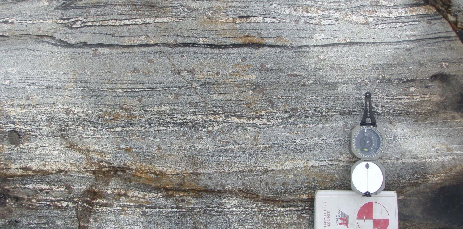
The Opinaca subprovince comprises a wide range of paragneiss and migmatites derived from feldspathic wacke. This metasedimentary complex, which can be a few kilometres thick, forms the Laguiche Complex and covers most of the area of the Opinaca Subprovince. The Laguiche Complex comprises several lithological assemblages, some of which have been divided according to the percentage of mobilisate present in the rock. Metasedimentary rocks of the Laguiche Complex mainly consist of paragneiss, metatexite and diatexite. In the Opinaca Reservoir area, paragneiss occur as decametric to kilometric strips extending over tens of kilometres. These rocks contain 20 to 50% tonalitic or granitic mobilisate and are characterized by well-developed migmatitic banding (Bandyayera and Fliszar, 2008). The eastern end of the Opinaca Subprovince is characterized by an assemblage of supracrustal rocks that host intrusive rocks. Supracrustal rocks belonging to the Hublet Group (Mercator Formation) consist of early gneiss that are likely derived from grauwacke and that contain volcanic rocks (Lamothe et al., 1998). These early gneiss resemble those described elsewhere in the Ashuanipi Subprovince (Percival et al., 1992; James, 1997). According to Lamothe et al. (2000), sedimentary rocks of the Hublet Group are likely equivalent to those of the Laguiche Complex, which form most of the western part of the Opinaca Subprovince.
Metasedimentary rocks of the Opinaca are intruded by multiple post-tectonic to late-tectonic intrusions consisting of granodiorite, pegmatitic granite and tonalite cutting paragneiss of the Laguiche Complex. These intrusions are peraluminous and type S (Moukhsil et al., 2003). Some small ultramafic intrusions are also present on the edge of the Opinaca Subprovince. However, their relationship with metasedimentary rocks of the Laguiche Complex is unknown. Finally, all Archean units of the Opinaca Subprovince are cut by Proterozoic diabase dykes belonging to the Mistassini, Senneterre and Matachewan swarms.
The magnetic signature of the Opinaca Subprovince is relatively weak and punctuated by intense linear anomalies, many of which correspond to strips of metavolcanic rocks and iron formations (Sharma, 1978; Chartrand and Gauthier, 1995; Gauthier, 1996). In the western part of the Opinaca Subprovince, the sedimentary assemblage formed by the Laguiche Complex and the Hublet Group forms the axial part of a large regional antiform with shallow dip to the NE, bordered to the east and north by the southern portion of the Ashuanipi Subprovince (Lamothe et al., 2000). In the Opinaca Reservoir area, rocks of the Opinaca Subprovince show a deformation pattern in domes and basins; the core of the domes is occupied by late granitic intrusions (Bandyayera et al., 2010). In general, the Opinaca Subprovince is characterized by increasing metamorphism towards the south from its contact with the La Grande Subprovince. Metamorphism changes from mid to upper amphibolite facies and reaches the granulite facies with the occurence of hypersthene in most detrital rocks.
Geological Evolution
The geological history of the Opinaca Subprovince is comparable to that of the Nemiscau and other sedimentary subprovinces that make up part of the Superior Province. The Opinaca Subprovince corresonds to the remains of a large sedimentary basin. The sedimentation age remains poorly known. A maximum age for sediment deposition of 2721 Ma was obtained on detrital zircons from the Mercator Formation (Wodicka et al., 2009). The deposition age of the Opinaca Subprovince would be between 2721 and 2671 Ma (David et al., 2011). This age range would also correspond to the deposition age of two sedimentary basins in the La Grande Subprovince, dated <2686 ±3 Ma and <2714 Ma (Ravenelle et al., 2008, 2010), north of the Opinaca Reservoir. These data suggest that the Opinaca Subprovince sedimentary rocks would not be younger than those of the La Grande Subprovince, as proposed by Goutier et al. (2002). Sedimentary units of the Opinaca and La Grande subprovinces could be contemporary or form several separate basins (Bandyayera et al., 2010). In addition, the Frégate Pluton is intrusive in the Laguiche Complex, thus sedimentary deposition responsible for paragneiss of the Laguiche Complex in the Richardie Lake area predates this intrusion dated 2710.4 ±2.4 Ma (Augland et al., 2016). Furthermore, the presence of mega-enclaves of migmatitized paragneiss from the Laguiche Complex in the Richardie Suite, dated 2693 ±2.4 Ma (Pichi Pluton), indicates that sediment deposition and initiation of the migmatitization episode began before 2693 Ma (Gigon and Goutier, 2017).
As with the Nemiscau Subprovince, the Opinaca Subprovince could represent the eastern extension of the English River Subprovince (Card, 1990). Other authors rather support the hypothesis of an eastern extension of the Quetico Basin. Percival (1989) and Percival and Williams (1989) propose that the Quetico, Nemiscau and Opinaca subprovinces, as well as the Ashuanipi Subprovince, could be a broad accretionary prism. The work of Doyon (2004) also suggests that the Quetico, Nemiscau and Opinaca basins are geochemically similar. Models proposed by Moukshil et al. (2003) and Percival (1989) argue that the Nemiscau, Opinaca and Quetico basins are considered to be back-arc basins due to the presence of sediments, mid-ocean ridge tholeiitic basalts (MORB), potassium-depleted tholeiitic rocks and syntectonic and synvolcanic plutons. Some hypotheses were put forward for understanding the geodynamic context of the formation of sedimentary sequences of the Laguiche Complex and its evolution during deformation and metamorphism episodes. According to Lapointe (2008), the structural signature of the Eeyou Istchee James Bay region is compatible with a central metamorphic complex centred on the Opinaca Basin (Laguiche Complex). Gold mineralization distributed on the periphery of the Opinaca Subprovince may be associated with decollement structures of such a complex. Bandyayera et al. (2010) showed that the Opinaca Subprovince is characterized by dome and basin structures that are locally stretched and dismembered. Mobilisate injections would preferentially be aligned with domes and the centre of basins would be occupied by late intrusions.
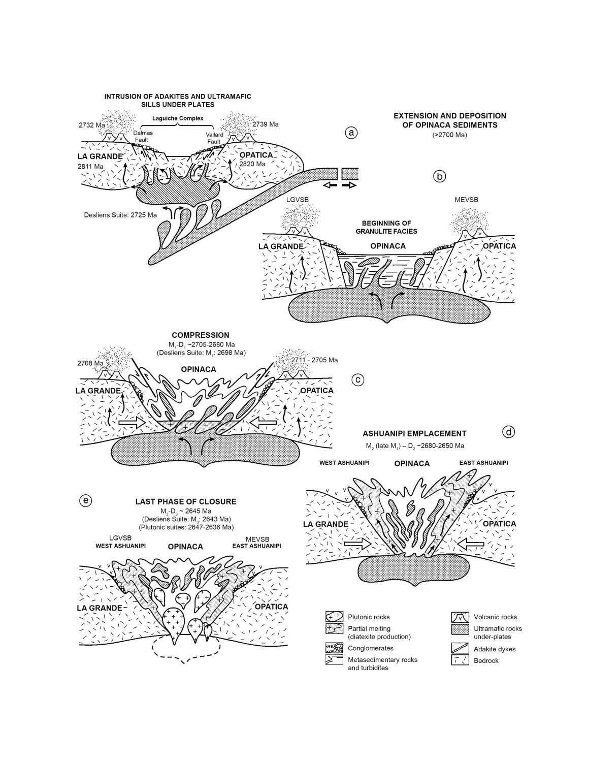
In its tectonometamorphic interpretation of the northern Superior Province, Cadéron (2003) established the first geothermobarometric data characterizing metasedimentary rocks of the Opinaca Subprovince. The Opinaca Subprovince is characterized by a polymetamorphic evolution over a period of 65 Ma, and structural data coupled with geothermobarometric results allowed for the proposition of a tectonometamorphic model of the Opinaca evolution. In this model, the Opinaca Subprovince represents an Archean intracontinental basin formed during an extension period. An ocean plate plunging towards the NW causes crustal thinning and extension, and formation of a graben that separates an Archean continental crust represented by the La Grande and Opatica subprovinces. Metasedimentary rocks of the Opinaca Subprovince would therefore come from erosion of the La Grande and Opatica subprovinces. A period of compression begins around 2705 Ma and continues until 2680 Ma, corresponding to emplacement of diatxites of the Ashuanipi Complex. Beginning of the closure of the Opinaca Basin would be contemporary with regional deformation phase D1 (2705-2680 Ma). During basin closure, the Opinaca overthrusts the La Grande Subprovince to the north and Opatica Subprovince to the southwest and would represent a double-verging structure. Ancient normal faults appear to have undergone recurrence of reverse movement in this process. Subsequently, the Ashuanipi (2680-2650 Ma) was emplaced and the compression phase (around 2645 Ma) was completed. During regional deformation phase D3, the Opinaca was folded and formed a large southward-overfold antiform structure.
References
| Author(s) | Title | Year of Publication | Hyperlink (EXAMINE or Other) |
|---|---|---|---|
| AUGLAND, L.E. – DAVID J. – PILOTE, P. – LECLERC, F. – GOUTIER, J. – HAMMOUCHE, H. – LAFRANCE, I. – TALLA TAKAM F. – DESCHÊNES, P.-L. – GUEMACHE, M. |
Datations U-Pb dans les provinces de Churchill et du Supérieur effectuées au GEOTOP en 2012-2013. Ministère de l’Énergie et des Ressources naturelles, Québec; RP 2015-01, 43 pages. | 2016 | RP 2015-01 |
| AVRAMTCHEV, L. | Catalogue des gîtes minéraux : région de la Baie-James. Ministère de l’Énergie et des Ressources, Québec; DPV 940, 34 pages, 16 plans. | 1976 | DPV 940 |
| BANDYARERA, D. – RHÉAUME, P. – MAURICE, C. – BÉDARD, E. – MORFIN, S.-J. – SAWYER, E.W. | Synthèse géologique du secteur du réservoir Opinaca, Baie-James. Ministère des Ressources naturelles et de la Faune, Québec; RG 2010-02, 46 pages, 1 plan. | 2010 | RG 2010-02 |
| CADÉRON, S. | Interprétation tectonométamorphique du nord de la Province du Supérieur, Québec, Canada; Thèse de doctorat, Université du Québec à Montréal, 314 pages. | 2003 | – |
| CARD, K.D. | A review of the Superior Province of the Canadian Shield, a product of Archean accretion. Precambrian Research; volume 48, pages 99-156. | 1990 | – |
| CARD, K.D. – CIESIELSKI, A. | Subdivisions of the Superior Province of the Canadian Shield. Geoscience Canada; volume 13, pages 5-13. | 1986 | – |
| CARLSON, E.H. | Rapport préliminaire sur la région du lac Pivert, territoire de Mistassini et Nouveau-Québec. Ministère des Richesses naturelles, Québec; RP 483, 1 plan. | 1962 | RP 483 |
| CHARTRAND, F. – GAUTHIER, M. | Cadre géologique et potentiel minéral des roches archéennes du bassin de La Grande Rivière, Baie-James. Ministère des Ressources naturelles, Québec; PRO 95-06, 10 pages. | 1995 | PRO 95-06 |
| DAVID, J. – VAILLANCOURT, D. – BANDYAYERA, D. – SIMARD, M. – GOUTIER, J. – PILOTE, P. – DION, C. – BARBE, P. | Datations U-Pb effectuées dans les sous-provinces d’Ashuanipi, de La Grande, d’Opinaca et d’Abitibi en 2008-2009. Ministère des Ressources naturelles et de la Faune, Québec; RP 2010-11, 37 pages. | 2011 | RP 2010-11 |
| DOYON, J. | Comparaison de la composition des roches métasédimentaires archéennes dans les bassins de la Province du Supérieur; une étude géochimique et statistique. Université du Québec à Chicoutimi; mémoire de maîtrise, 214 pages. | 2004 | – |
| DUBÉ, C. – FRANCONI, A. – HOCQ, M. – REMICK, J.H. – SHARMA, K.N.M. – AVRAMTCHEV, L. – DUCROT, C. | Compilation géologique du territoire de la Baie-James, Ministère des Richesses naturelles, Québec; DP-358, 8 pages, 18 plans. | 1976 | DP 358 |
| EADE, K.E. | Fort George and Kaniapiskau river (west half) map-areas, New Quebec. Geological Survey of Canada; memoir 339, 83 pages. | 1966 | Source |
| EAKINS P.R. | Rapport préliminaire sur la région du lac Natel, territoire de Mistassini et Nouveau-Québec. Ministère des Richesses Naturelles, Québec; RP 454, 1 plan. | 1961 | RP 454 |
| EAKINS P.R. – HASHIMOTO, T. – CARLSON, E.H. | Région de Grand-Détour – Lacs Village, territoire de Mistassini et Nouveau-Québec. Ministère des Richesses Naturelles, Québec; RG 136, 53 pages, 3 plans. | 1968 | RG 136 |
| FRANCONI, A. | Région de la Gorge Prosper. Ministère de l’Énergie et des Ressources, Québec; MM 82-02, 69 pages, 5 plans. | 1983 | MM 82-02 |
| GAUTHIER, M. | Géologie de la région du lac Sauvolles. Ministère des Ressources naturelles, Québec; MB 96-27, 1 plan. | 1996 | MB 96-27 |
| GIGON, J. – GOUTIER, J. | Géologie de la région du lac Richardie, municipalité d’Eeyou Istchee Baie-James. Ministère des Ressources naturelles et de la Faune, Québec; RG 2016-04, 45 pages, 1 plan. | 2017 | RG 2016-04 |
| GOUTIER, J. – DION, C. – OUELLET, M.-C. – DAVIS, D., W. – DAVID, J. – PARENT, M. | Géologie de la région du lac Guyer (33G/05, 33G/06 et 33G/11). Ministère des Ressources naturelles, Québec; RG 2001-15, 55 pages, 3 plans. | 2002 | RG 2001-15 |
| GOUTIER, J. – DION, C. – OUELLET, M.C. – MERCIER-LANGEVIN, P. – DAVIS, D.W | Géologie de la Colline Masson, de la Passe Awapakamich, de la Baie Caribellet et de la Passe Pikwahipanan (SNRC 33F/09, 33F/10, 33F/15 et 33F/16). Ministère des Ressources naturelles, Québec; RG 2000-10, 69 pages, 4 plans. | 2001 | RG 2000-10 |
| GOUTIER, J. – DION, C. – OUELLET, M.-C. – DAVID, J. – PARENT, M. | Géologie de la région des lacs Guillaumat et Sakami (33F/02, 33F/07). Ministère des Ressources naturelles, Québec; RG 99-15, 40 pages, 2 plans. | 2000 | RG 99-15 |
| HASHIMOTO, T. | Rapport préliminaire sur la région des lacs Village, territoire de Mistassini et Nouveau-Québec. Ministère des Richesses Naturelles, Québec; RP 473, 12 pages, 1 plan. | 1962 | RP 473 |
| HEYWOOD, W.W. – BRETT, S.E. – CURRIE, K.L. – EADE, K.E. | La Grande – Lac Bienville, New Quebec. Geological Survey of Canada; map 23-1958. | 1959 | Source |
| HOCQ, M. | Géologie de la région du lac Cadieux (Nouveau-Québec). Ministère des Richesses naturelles, Québec; DPV 433, 19 pages, 1 plan. | 1976 | DPV 433 |
| HOCQ, M. | Géologie de la région des lacs Campan et Cadieux, territoire du Nouveau-Québec. Ministère de l’Énergie et des Ressources, Québec; ET 83-05, 190 pages, 4 plans. | 1985 | ET 83-05 |
| HOCQ, M. | Géologie du Québec, les publications du Québec, Québec. Ministère des Ressources naturelles; MM 94-01, 172 pages. | 1994 | MM 94-01 |
| INTISSAR, R. – BENAHMED, S. | Levé magnétique aéroporté dans le secteur du lac vallard, au sud-ouest de Fermont. Ministère des Ressources naturelles, Québec; DP 2013-01, 6 pages, 84 plans. | 2013 | DP 2013-01 |
| JAMES, D.T. | Geology of the archean Ashuanipi Complex, western Labrador. Newfoundland-and-Labrador Department of Mines and Energy, Geological Survey Branch; Report 97-2, 27 pages. | 1997 | – |
| LAMOTHE, D. – LECLAIR, A. – CHOINIÈRE, J. | Géologie de la région du lac Vallard, Ministère des Ressources naturelles, Québec; RG 98-13, 35 pages, 1 plan. | 1998 | RG 98-13 |
| LAMOTHE, D. – THÉRIAULT, R. – LECLAIR, A. | Géologie de la région du lac Nitchequon (SNRC 23 E). Ministère des Ressources naturelles, Québec; RG 99-14, 46 pages, 1 plan. | 2000 | RG 99-14 |
| LAPOINTE, I. | Environnements sédimentaires aurifères en terrain de haut grade métamorphique : le cas des bassins sédimentaires d’Opinaca-Nemiscau, Baie-James. Rapport du CONSOREM 2007-07, 36 pages. | 2008 | Source |
| LECLAIR, A. – LAMOTHE, D. – CHOINIERE, J. – PARENT, M. | Géologie de la région du lac Bermen (SNRC 23F). Ministère des Ressources naturelles, Québec; RG 97-11, 42 pages, 2 plans. | 1998 | RG 97-11 |
| MILLS, J.P. | Sakami Lake (South area). Ministère de l’Énergie et des Ressources, Québec; DP-100, 18 pages, 1 plan. | 1965 | DP 100 |
| MILLS, J.P. | Sakami Lake (North area). Ministère de l’Énergie et des Ressources, Québec; DP 148, 9 pages, 1 plan. | 1973 | DP 148 |
| MILLS, J.P. | Petrological studies in the Sakami-Lake greenstone belt of northwestern Quebec. University of Mansas; thèse de doctorat, 190 pages, 2 plans. | 1974 | – |
| MOUKHSIL, A. – LEGAULT, M. – BOILY, M. – DOYON, J. – SAWYER, E.W. – DAVIS, D.W. | Synthèse géologique et métallogénique de la ceinture de roches vertes de la Moyenne et de la Basse-Eastmain (Baie-James). Ministère des Ressources Naturelles, de la Faune et des Parcs, Québec; ET 2002-06, 57 pages, 1 plan. | 2003 | ET 2002-06 |
| PERCIVAL, J.A. | A regional perspective of the Quetico metasedimentary belt, Superior Province, Canada. Canadian Journal of Earth Sciences; volume 26, pages 677-693. | 1989 | Source |
| PERCIVAL, J.A. – WILLIAMS, H.R. | Late Archean Quetico accretionary complex, Superior Province, Canada. Geology; volume 17, pages 23-25. | 1989 | Source |
| PERCIVAL, J.A. – MORTENSEN, J.K. – STERN, R.A. – CARD, K.D. – BEGIN, N.J. | Giant granulite terranes of northeastern Superior Province; the Ashuanipi Complex and Minto Block. Canadian Journal of Earth Sciences; volume 29, pages 2287-2308. | 2000 | Source |
| RAVENELLE, J.-F. – DUBÉ, B. – MALO, M. – McNICOLL, V. – NADEAU, L. – SIMONEAU, J. – BÉCU, V. – GAUTHIER, M. – BANDYAYERA, D. | Géologie, structure et hydrothermalisme du gisement aurifère de classe mondiale Roberto, propriété Éléonore, Baie-James, Québec. Ministère des Ressources naturelles et de la Faune, Québec; DV 2008-06, page 24. | 2008 | DV 2008-06 |
| RAVENELLE, J.-F. – DUBÉ, B. – MALO, M. – McNICOLL, V. – SIMONEAU, J. | Insights of the geology of the World-class Roberto gold deposit, Eleonore property, James Bay, Québec. Geological Survey of Canada, Current Research (Online); no. 2010-1, 29 pages. | 2010 | Source |
| SHARMA, K.N.M. | Région de La Grande Rivière. Ministère des Richesses naturelles, Québec; RG-184, 83 pages, 3 plans. | 1977 | RG 184 |
| SHARMA, K.N.M. | Région de La Grande Rivière. projet 1977, rapport préliminaire. Ministère des Richesses naturelles, Québec; DPV-558, 38 pages, 1 plan. | 1978 | DPV 558 |
| SIMARD, M. – GOSSELIN, C. | Géologie de la région du lac Lichteneger (SNRC 33B). Ministère des Ressources naturelles, Québec; RG 98-15, 27 pages, 1 plan. | 1999 | RG 98-15 |
| TALLA TAKAM, F. – BEAUCHAMP, A.M. – MASSEI, F. | Levé géologique au nord-est de Mistissini, à la limite entre les sous-provinces de La Grande, d’Opinaca et d’Opatica, Eeyou Istchee Baie-James (régions du lac Emmanuel et du lac Léran). Ministère de l’Énergie et des Ressources naturelles, Québec. | In preparation | – |
| WODICKA, N. – LAMOTHE, D. – LECLAIR, A. | Géochronologie U-Pb du Projet Ashuanipi. Ministère des Ressources naturelles et de la Faune, Québec; MB 2009-03, 21 pages. | 2009 | MB 2009-03 |