

First published: 3 December 2020
Last modified:
DISCLAIMER: This English version is translated from the original French. In case of any discrepancy, the French version shall prevail.
| Author(s): | Bérard, 1965; Clark, 1979 |
| Age: | Paleoproterozoic |
| Stratotype: | Two type localities: 1) south of Feuilles Lake, Siugak Lake area (58°20’N, 70°12’W, NTS sheet 24L08); 2) west of Napier Lake (57°52’N, 70°08’W; sheet 24E16) |
| Type area: | Bérard Lake area (NTS sheet 24L08) |
| Geological province: | Churchill Province |
| Geological subdivision: | New Quebec Orogen (Labrador Trough) / Bérard Lithotectonic Zone |
| Lithology: | Arkose, conglomerate, siltstone, mudstone and dolomite |
| Category: | Lithostratigraphic |
| Rank: | Formation |
| Status: | Formal |
| Use: | Active |
None
Background
The name Chioak Formation was proposed by Bérard (1965) for a succession of conglomerate, sandstone and pelitic sedimentary rock on the western edge of the Labrador Trough, SW of Feuilles Lake (sheets 24L01, 24L08, 24L09). Siugak Lake, formerly known as Chioak Lake (sheet 24L08), lies within a large outcropping area of the Chioak Formation. Further south, the formation was mapped by Clark (1977, 1979) between Imbault and Forbes lakes (sheets 24E08, 24E09, 24E16, 24F04 and 24F05). The name Chioak comes from the Inuktitut language and means “granular sandstone”. The Tamarack River Formation, located south of Schefferville, Labrador (Ware and Wardle, 1979; Ware, 1980), is homotaxial to the Chioak Formation (Clark and Wares, 2004).
Description
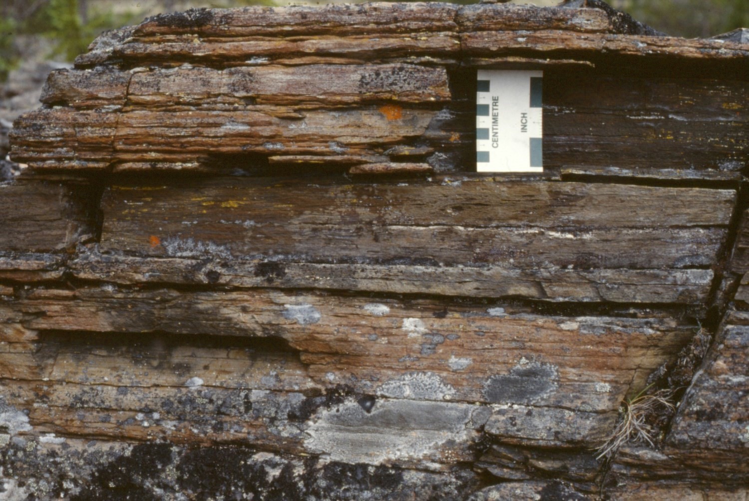
North of latitude 58°N, the Chioak Formation was mapped by Bérard (1965) without being divided. He described it as a package of sandstone, conglomerate and pelitic sedimentary rocks (see description of undivided unit pPck).
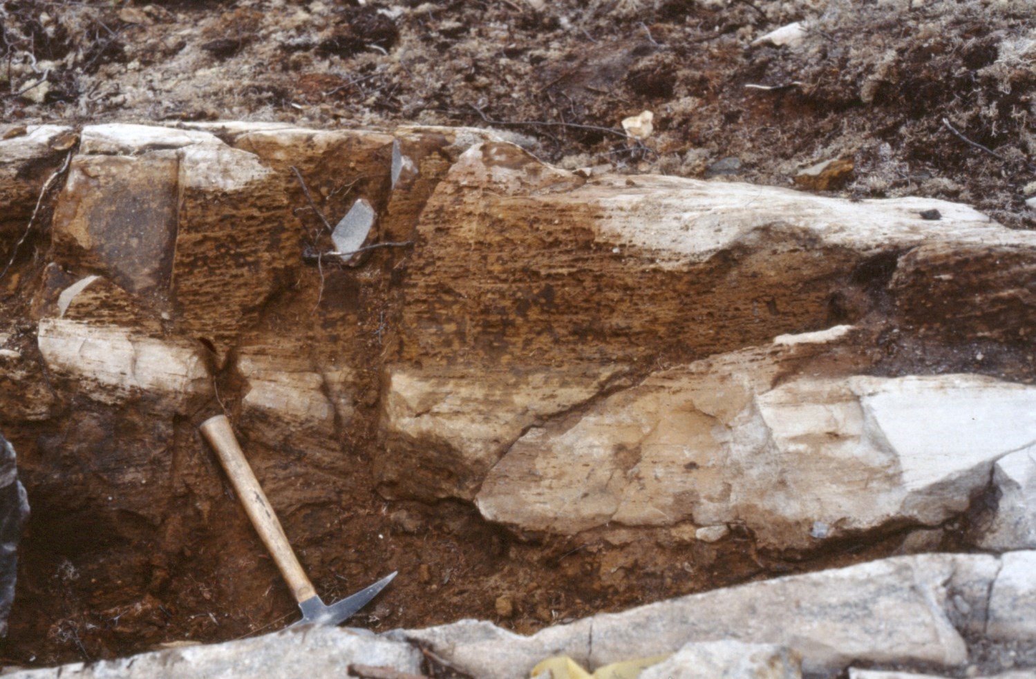
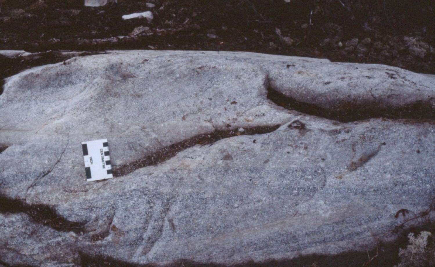
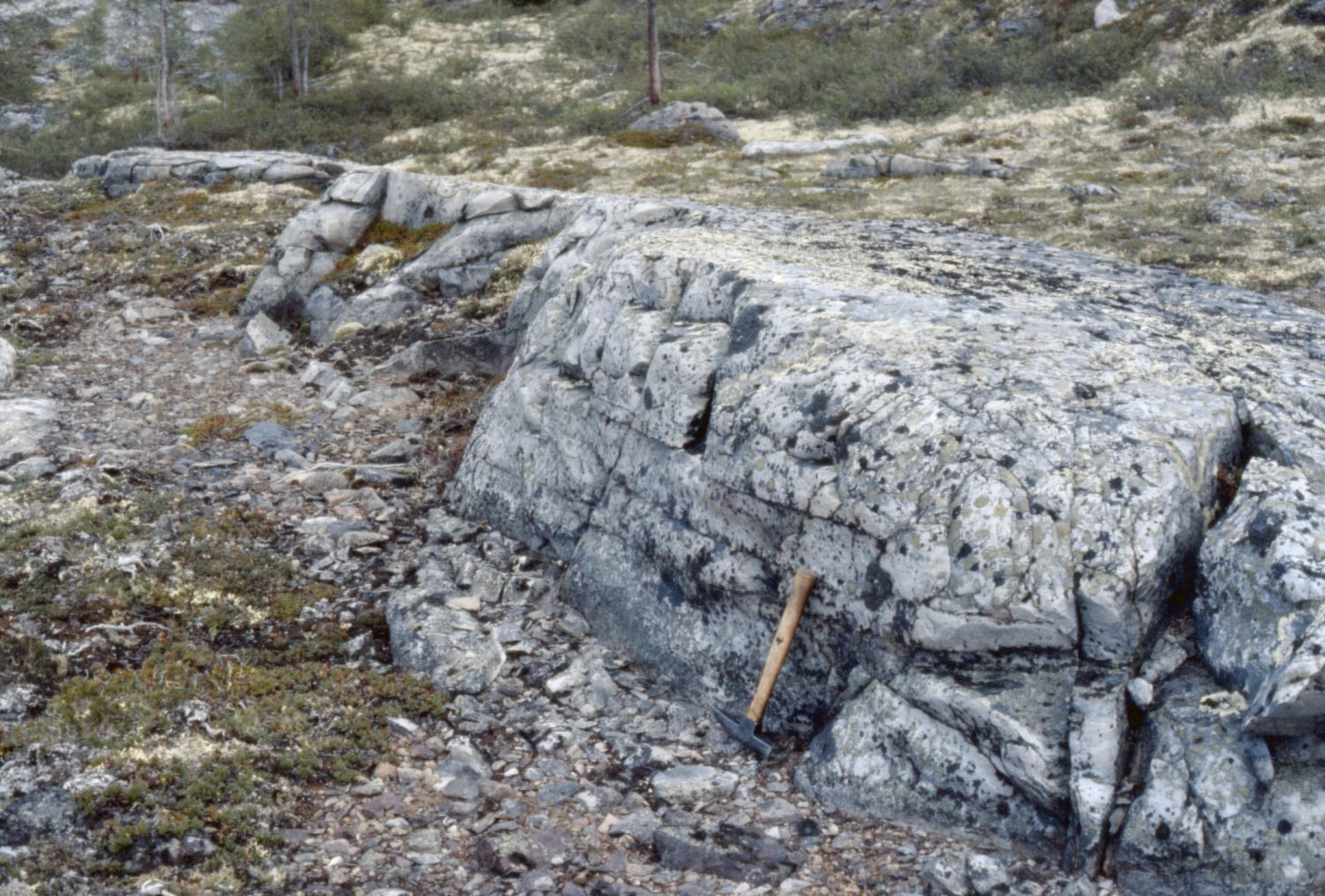
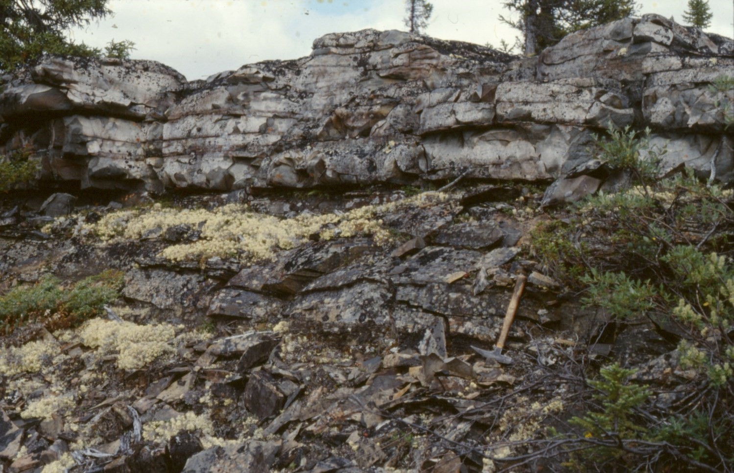
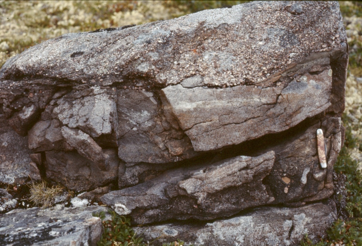
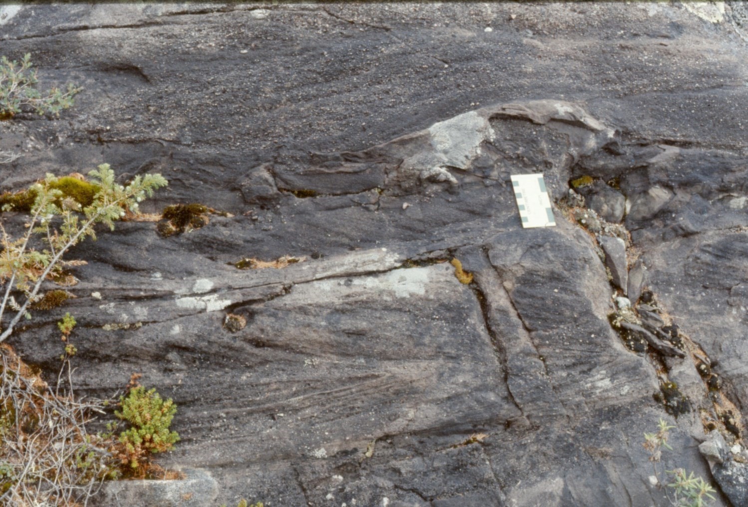
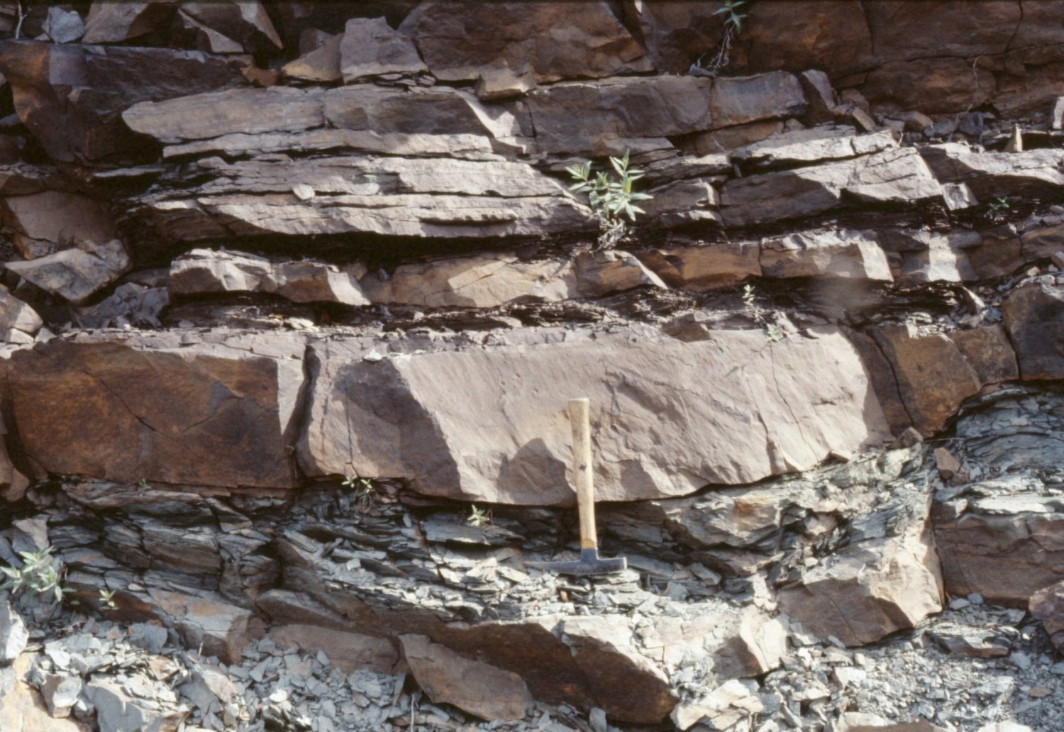
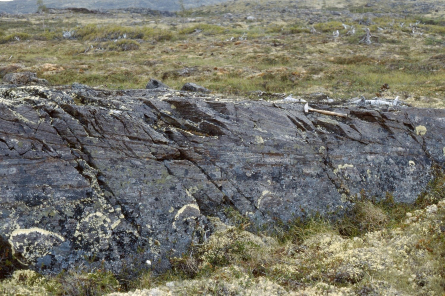
South of latitude 58°N, between Imbault and Napier lakes (sheet 24E16), the Chioak Formation was divided into three main members (Clark, 1979). This subdivision is probably of local value only. The lower member (informal unit pPck2) unconformably overlies Archean granitic bedrock along the western edge of the Labrador Trough. It consists of interbedded pebble, cobble and boulder conglomerate and arkose (1-18 m thick). The second member (informal unit pPck5), a sequence of red beds, consists of impure arkose and ferruginous feldspathic greywacke (15-23 m thick). Locally there are interbedded reddish siltstone and mudstone, polymictic conglomerate (brownish chert, quartzite and granite pebbles), reddish stromatolitic dolomite and sandstone dolomite. The third member (a repeat of unit pPck2), which is the upper member structurally located below the Denault Formation (known as the Abner Formation at the time), consists of interbedded jasper pebble-rich polymictic conglomerate and pinkish green sandstone (≥153 m thick). The internal stratigraphy of the third member is highly variable; the table below illustrates its composition at one location where it is relatively thick. The overall thickness of these three members in this area is ≥169 m.
Representative Section (Top-Down) of the Upper Member of the Chioak Formation (Unit pPck2, Interbedded Polymictic Conglomerate and Sandstone) (Adapted From Clark, 1979) Locality: 2 km west of Napier Lake (UTM NAD83, zone 19: 432800 m E, 6414449 m N (57°52’N, 70°08’W; sheet 24E16) | ||||||||||
| Thickness (m) | Description | |||||||||
| – | Dolomite of the Denault Formation (formerly Abner Formation) | |||||||||
| – | Hidden contact interpreted as a major thrust fault (Garigue Fault) | |||||||||
| 25 | Polymictic conglomerate containing quartz, siltstone, sandstone, jasper, granite and dolomite pebbles | |||||||||
| 15 | Medium-grained, greyish green conglomeratic sandstone | |||||||||
| 3 | Clast-supported polygenic conglomerate containing granite, quartz and jasper cobbles and boulders. The fragments are generally 15 cm in size, but can reach 30 cm. | |||||||||
| 55 | Polymictic conglomerate containing jasper and sandstone pebbles, cobbles and boulders. Fragments, up to 30 cm in diameter, are generally well rounded, but those composed of jasper may be angular. Very poor sorting. Massive and thick beds. Little or no interbedded sandstone. | |||||||||
| 25 | Massive, grey to greenish-grey sandstone in thick beds. Grains are ~1 mm in size and many consist of jasper. | |||||||||
| >30 | Polymictic conglomerate, containing mainly jasper pebbles, with some interbedded sandstone | |||||||||
| – | Hidden contact | |||||||||
Near the Aigneau River (sheet 24F05), the lower part of the Chioak Formation consists of a thick (~140 m) sequence of interbedded grey to greenish grey fine-grained sandstone, siltstone and mudstone (pPck3). The abundance of mudstone and siltstone relative to sandstone increases towards the top. Sandstone is massive or laminated, but in places it exhibits crossbedding. Siltstone is laminated and locally displays current ripples. This sequence locally contains interbedded conglomerate, pebbly dolomitic sandstone and dolomite (pPck4). It is successively overlain by greyish arkose (~20 m; pPck1), fine to medium-grained red arkose locally containing small jasper fragments (15 m; pPck5), red-brown dolomite (2.5 m; pPck4) and, at the top, fine to medium-grained, locally conglomeratic, greenish grey carbonate cement arkose (>20 m; pPck1).
Bérard (1965) noted that the composition of sandstone and arkose of the Chioak Formation directly reflects the composition of source rocks in Archean bedrock or in the older sedimentary sequence of the Trough. Deposition of sediments, by water and wind, would have been rapid. Water currents would have produced crossbedding and erosional structures at the base of the beds. Coarser sediments would have been deposited close to bedrock in the west, while finer materials would have been transported further east. Bérard (1965) cited evidence that the climate at the time was tropical and humid, and proposed a deltaic environment for the deposition of the Chioak Formation.
Based on folds observed near the base of the Chioak Formation, Bérard (1965) proposed that tectonic activity began during deposition of the formation. During this deformation, synsedimentary faults would have developed and created isolated sedimentary basins. Much detrital material, particularly from Archean granites, would have accumulated in high energy environments near faults. Other materials would have been derived from erosion of the uplifted sedimentary terrain. In rivers, the current would have given rise to decimetric beds featuring tabular/planar and pit crossbedding as well as ripples. The detrital material would have been deposited under oxidizing to reducing conditions, producing red, grey or green rocks, commonly alternating. The presence of carbonate and stromatolitic beds suggests periodic incursions of shallow, calm marine water.
Detrital sedimentary rocks of the Chioak Formation were interpreted as molasse (Hoffman, 1987, 1988; Clark and Wares, 2004). They are evidence of syntectonic erosion of uplifted terrain during the Hudsonian Orogenesis. Deposition of sedimentary rocks would have occurred in a foredeep setting.
The economic importance of the Chioak Formation lies mainly in its uranium potential. Informal lithostratigraphic units pPck, pPck1 and pPck5 contain most of the known radioactive mineralization. For example, the Chioak mineralized zone (sheet 24L01) contains disseminated uranium-thorium-copper mineralization in a poorly sorted, locally conglomeratic, greenish grey or red arkose (Kish and Tremblay-Clark, 1978). Most of radioactive mineralization is disseminated between clastic grains, but some occurs in microfractures. Pyrite and chalcopyrite are common accessory minerals. SW of Forbes Lake (sheets 24F04 and 24F05), radioactive minerals (locally accompanied by sulphides) are disseminated in greyish patina arkose (Uranerz [August] mineralized zone); they also occur in fractures that cut arkose. At Imbault Lake (sheet 24E16), radioactive minerals are found in a thin bed of stromatolitic dolomite having a red-brown patina.
According to Clark and Wares (2004, p. 63): “In the northern part of the orogen (Bérard Zone), abundant sedimentary-hosted uranium mineralization was discovered in the Chioak Formation molasse. Uranium mineralization is accompanied by either thorium, vanadium or copper sulphides. Mineralization generally consists of pitchblende disseminated in the matrix of sandy sedimentary rocks.” It should be noted that the Tamarack River Formation, in Labrador, was also recognized for its uranium potential (Ware and Wardle, 1979; Ware, 1980). Still according to Clark and Wares (2004, p. 64), mineralization is “attributed to the rise of diagenetic fluids along normal faults and the circulation of these fluids in permeable horizons […]. Emplacement of mineralization appears to be related to changes in redox conditions at the depositional site.”
Chioak Formation, Undivided (pPck): Arokosic Sandstone, Conglomerate, Arkosic Conglomerate, Mudstone and Sandstone of Various Colours; Locally Radioactive Minerals
This undivided unit includes all the lithologies observed in the Chioak Formation, mainly north of latitude 58° N, i.e. the area mapped by Bérard (1965). According to Bérard (1965), the Chioak Formation consists of sandstone, conglomerate and pelitic sedimentary rock. Sandstone is the most common rock. This author noted a wide variation in lithofacies, both laterally and vertically. Lateral variations are granulometric in nature, while vertical changes are compositional. According to Bérard (1965), the wide variations observed make it impossible to establish marker layers. Furthermore, the work of Clark (1977, 1979) confirmed that the stratigraphy of the Chioak Formation varies regionally. The rocks’ classification can be refined on the basis of the mineralogy of detrital grains and the nature of cements. The following descriptions of the lithofacies of the Chioak Formation are derived primarily from Bérard (1965), with additional information from Clark (1977, 1979, and unpublished data). Locally, these sedimentary rocks contain radioactive minerals.
The sandstone is composed of detrital grains that reflect the nature of the parent rock, whether it is granite, Archean gneiss or older sedimentary rocks of the Labrador Trough. Its colour depends on the cement, which can be of various compositions: pelitic, ferrodolomitic, ferruginous or siliceous. Minerals in the cement include hematite, goethite, ferrodolomite, calcite, silica (chert) and chlorite. The intergranular material may also be composed of fine rock particles or granitic material. The pink arkose is composed of K-feldspar and quartz cemented by sericite, calcite and chlorite; crossbedding is common. This rock is derived from the erosion of pink bedrock granite. Black sandstone, which is interbedded with conglomerate and black shale, forms beds 0.3 to 1 m thick. It is mainly composed of quartz, K-feldspar, plagioclase, hematite, chert and clay minerals; its composition corresponds to that of a “subgreywacke”. The black colour is due to the nature of iron oxides (e.g. magnetite) and, locally, to the presence of graphite. Black sandstone was formed by breakdown of Archean dioritic rocks. Interbedded conglomerate contains black chert pebbles. Light grey sandstone forms massive beds 0.3 to 2 m thick. This rock is mainly composed of K-feldspar, quartz and plagioclase, and probably originates from erosion of Archean granodiorites. Pelitic “cement” sandstone is formed of detrital grains in an argillaceous matrix; this rock is essentially a turbidite deposit. Ferrodolomitic cement sandstone has a light to dark brown alteration patina. This rock forms 1 m thick layers interbedded with black and grey sandstones. Depending on the proportion of carbonate cement observed, sandstone is transitional to sandy ferrodolomite. Ferruginous cement sandstone is interbedded with pink sandstone and arkosic conglomerate. Its brick-red colour is due to the presence of goethite, hematite and jasper. Crossbedding is common. Siliceous cement sandstone, a rare and discontinuous lithofacies, is characterized by a cement of chert and secondary quartz. This lithofacies includes quartzitic sandstone commonly associated with black sandstone.
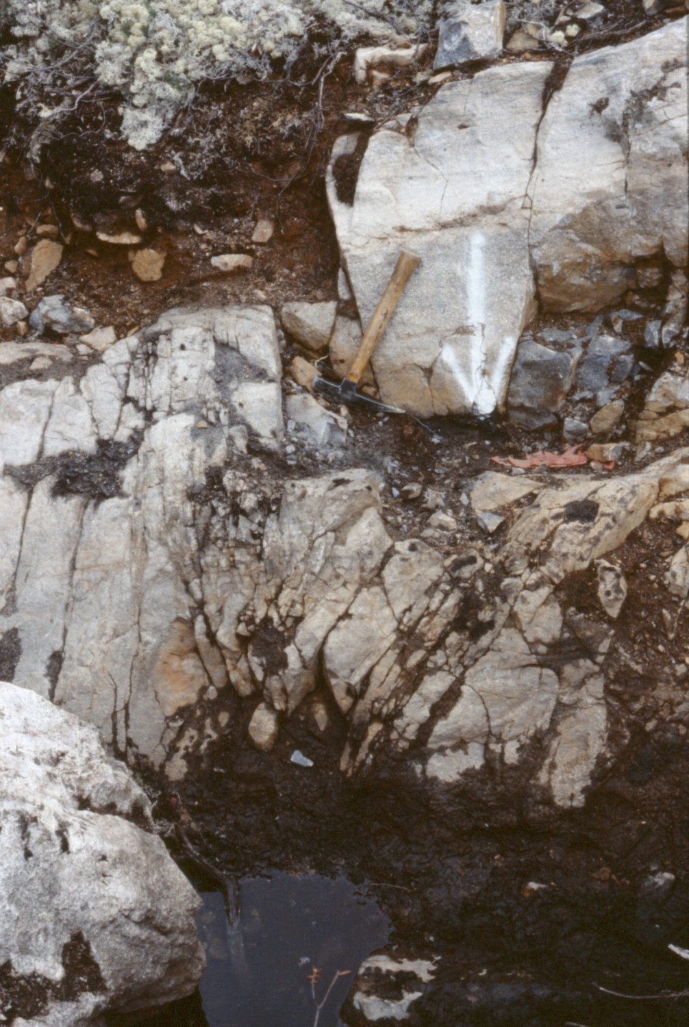
Arkosic conglomerate contains granite fragments up to 1 m in diameter. The fragments’ matrix is arkosic and the cement is predominantly composed of calcite and clay minerals. This conglomerate is interbedded with arkosic sandstone. In places, it consists of basal conglomerate formed by the in situ breakdown of underlying granitic bedrock. Polymictic conglomerate, which reaches a thickness of 46 m in the area mapped by Bérard (1965), contains fragments from several older units: granite, gneiss, dolomite, siltstone, shale, quartzite, jasper, iron formation and conglomeratic sandstone. Fragments are well rounded and hosted in red arkosic sandstone; the cement consists of quartz, ferrodolomite and hematite. According to Bérard (1965), folding deformation affected the source rocks of sedimentary fragments prior to erosion. Cherty conglomerate is the most common conglomerate and outcrops almost everywhere along the contact with Archean bedrock (Bérard, 1965). Pebbles, cobbles and boulders are generally of grey or black chert composition and are hosted in an arkosic matrix. Quartz, quartzite, granite, gneiss, shale and jasper fragments are also present. The cement is variably composed of silica, chert, ferrodolomite, clay minerals or chlorite.
Pelitic sedimentary rocks (mudstone, shale and siltstone) are red, green, black or grey. They form relatively thick beds distributed throughout the formation. They represent the micro-grained facies of sandstone and conglomerate, and their abundance relative to sandstone increases eastwards. In pelitic sedimentary rocks, up to 50% of the rock consists of angular detrital grains, which are composed of quartz, K-feldspar and chert. The matrix is composed of illite and chlorite. Some mudstone and black shale beds are enriched in magnetite, others in graphite and pyrite. Mudstone and red shale are enriched in goethite and interbedded with ferruginous sandstone.
Chioak Formation 1 (pPck1): Arkosic Sandstone with Grey, Greenish Grey or Pinkish Grey Patina; Interbedded Arkosic Polymictic Pebble Conglomerate, Arkose, Sandy Dolomite and Dolomite; Locally Radioactive Minerals
Unit pPck1 consists mainly of arkosic sandstone having a grey, greenish grey or pinkish grey patina and a fine to coarse grain size. Sandstone features various types of crossbedding. It comprises interbedded polymictic conglomerate having an arkosic matrix and containing variable amounts of small fragments and pebbles of granite, quartz, feldspar, jasper, quartzitic arenite, grey chert, sandstone and dolomite. Also present are interbedded carbonate matrix arkose, locally conglomeratic, sandy dolomite and dolomite. Locally, radioactive minerals are disseminated in some beds or concentrated in fractures. SW of Forbes Lake (sheets 24F04 and 24F05), this unit contains most of the radioactive mineral occurrences (see August mineralized zone).
Chioak Formation 2 (pPck2): Polymictic Arkosic Pebble, Cobble and Boulder Conglomerate; Interbedded Arkose with Grey or Greenish Grey Patina
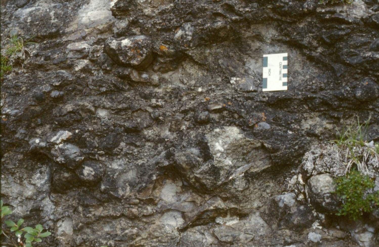
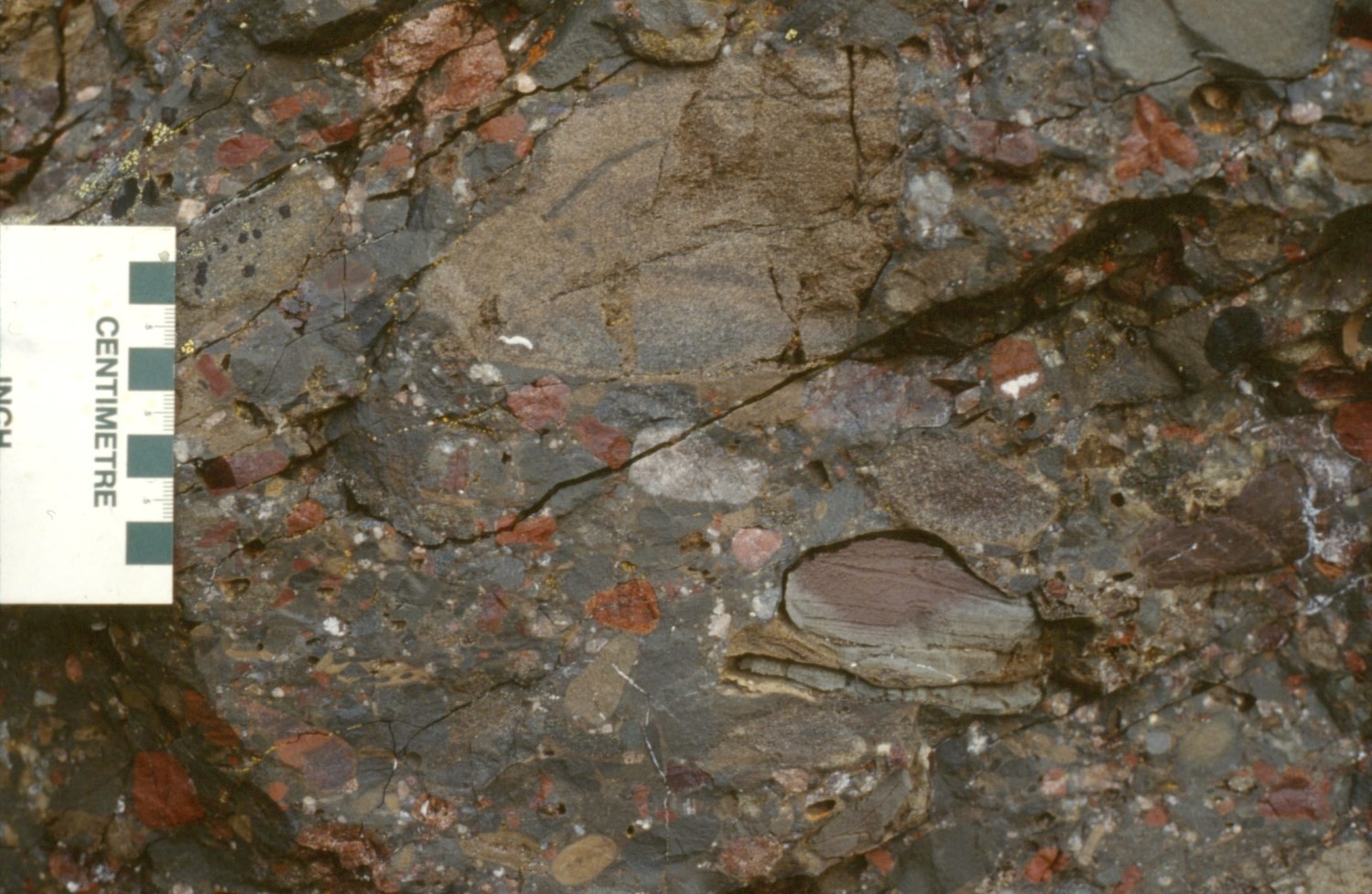
Unit pPck2 consists mainly of polymictic pebble, cobble and boulder conglomerate, which contains abundant interbedded arkose. Fragments consist mainly of granite and jasper, locally grey or black chert, quartzitic arenite, dolomite, iron formation, siltstone, shale, red sandstone or gneiss in very variable amounts. In several places, the unit is in direct contact with Archean granitic bedrock. In other places, it is underlain by other lithofacies of the Chioak Formation. The thickness of the unit varies from 1 to 45 m. The beds’ thickness varies from 5 cm to 2 m. Crossbedding is present locally, and erosion channels mark the base of the beds in places. Rocks are pinkish grey to salmon-pink in fresh surface. In pink granite pebble conglomerates, fragments are rounded and <1 cm to 2 m in diameter; they are hosted in a matrix of arkosic sandstone, which is locally cemented by carbonates. Arkose is mainly composed of feldspar and quartz and the cement consists locally of carbonates.
Chioak Formation 3 (pPck3): Interbedded Mudstone, Siltstone and Sandstone, with Grey or Greenish Grey, Locally Brown or Red Patina; Locally Interbedded Polymictic Conglomerate, Dolomite, Stromatolitic Dolomite, Dolomitic Sandstone or Arkose
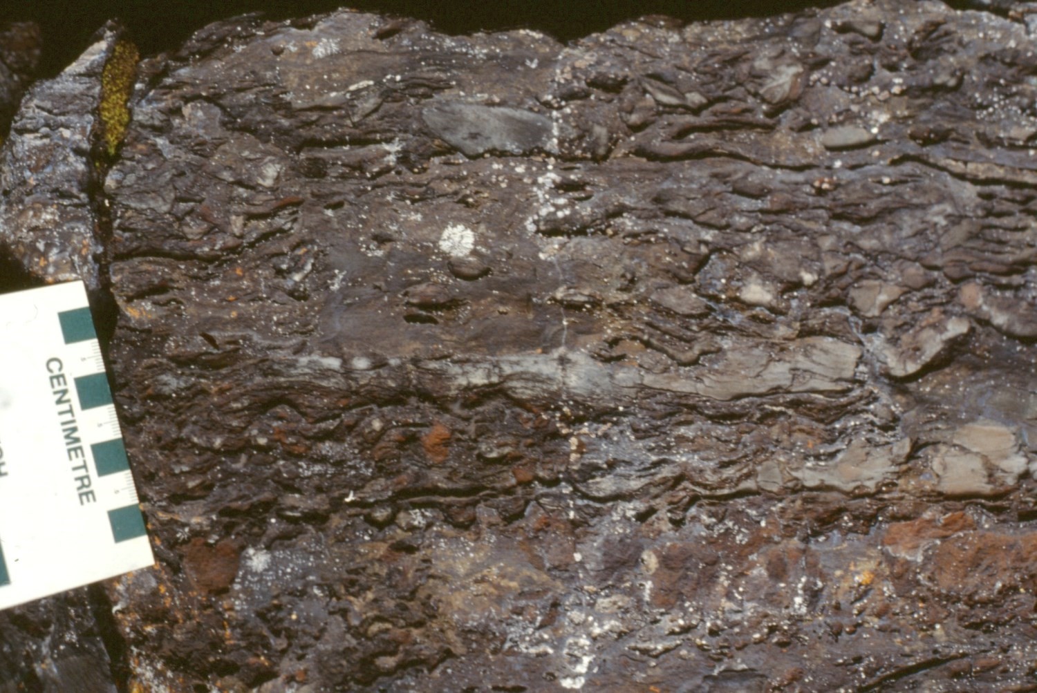
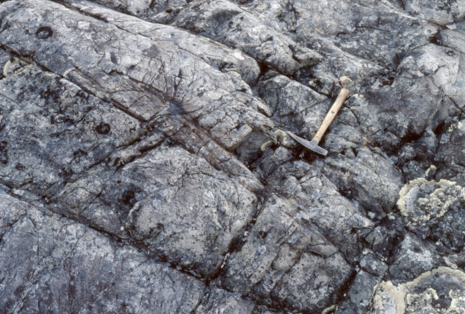
Unit pPck3 consists mainly of interbedded mudstone, siltstone and sandstone in varying proportions. The rock is predominantly grey or greenish grey, with a local brown, red-brown or red patina. Siltstone is laminated or massive. Sandstone is fine grained and locally exhibits planar crossbedding and ripples. The rock is locally carbonatized. Interstratifications and lenses of conglomerate, dolomitic sandstone, dolomite or stromatolitic dolomite are present in places. Some interbedded conglomerate contains grey chert or jasper pebbles, which may be hosted in a matrix of oolitic dolomite. Some dolomite beds consist of intraformational conglomerate.
Chioak Formation 4 (pPck4): Dolomite, Laminated Dolomite with Local Algal Structures, Sandy Dolomite, Conglomeratic Dolomite, with Brown or Red-Brown Patina; Locally Radioactive Minerals
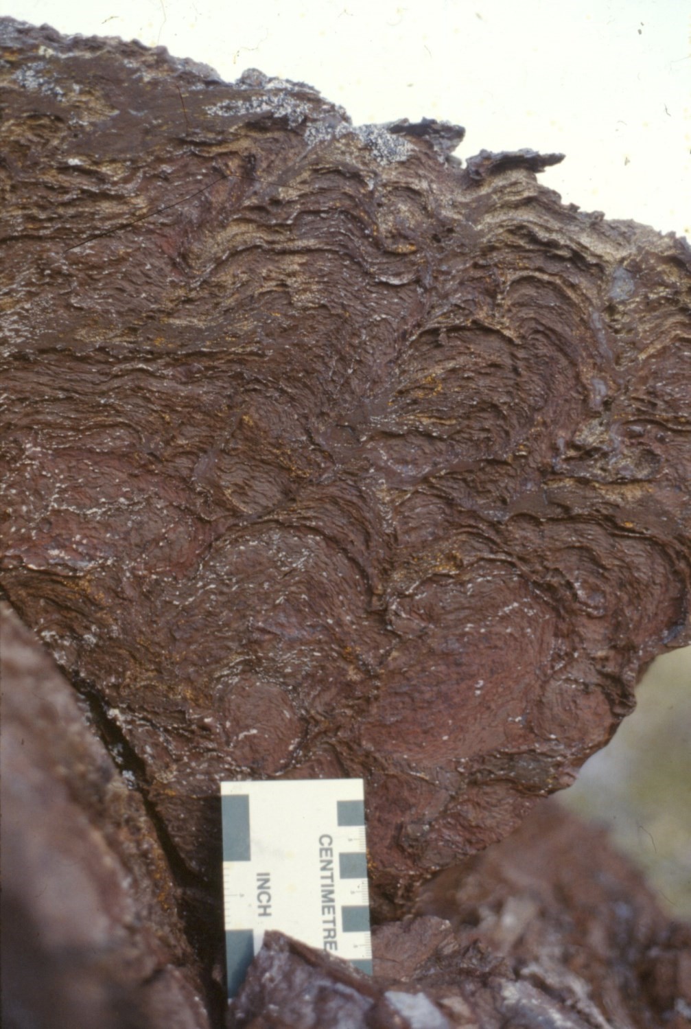
Unit pPck4 includes dolomite, laminated dolomite having cryptalgal or locally stromatolitic structures, sandy dolomite and conglomeratic dolomite. These dolomitic rocks commonly have a brown or red-brown patina. The beds vary in thickness from a few centimetres to 8 m. A metric bed of red-brown stromatolitic dolomite observed east of Imbault Lake (latitude 57° 55′ N, sheet 24E16) contains radioactive minerals.
Chioak Formation 5 (pPck5): Arkose with Pink, Red, Red-Brown or Purple Patina (Red Beds), Locally Greenish; Interbedded Polymictic Arkosic Pebble Conglomerate, Siltstone, Mudstone and Reddish Brown Dolomite; Locally Radioactive Minerals
Unit pPck5 consists of fine to very coarse-grained arkose and interbedded conglomerate. Arkose displays pit, oblique-planar and tangential crossbedding. The rock commonly has a red-brown patina (giving this lithofacies the name red beds), but may also be grey, greenish grey or green. Conglomerate contains pebbles of variable composition, particularly granite, jasper, quartzitic arenite and siltstone, in an arkosic matrix. The unit contains interbedded siltstone, mudstone and dolomite having a reddish brown patina. Radioactive minerals are present locally.
Chioak Formation 6 (pPck6): Subarkosic Sandstone and Quartzite with Grey Patina; Locally Interbedded Polymictic Pebble Conglomerate
Unit pPck6 consists of fine to medium-grained subarkosic sandstone and quartzitic arenite. The rock has a grey patina. Beds are massive or laminated and decimetre to metre thick. Locally, the cement consists of carbonates. The unit includes interbedded conglomerate containing quartz, feldspar, grey chert, quartzitic arenite and jasper fragments.
Thickness and distribution
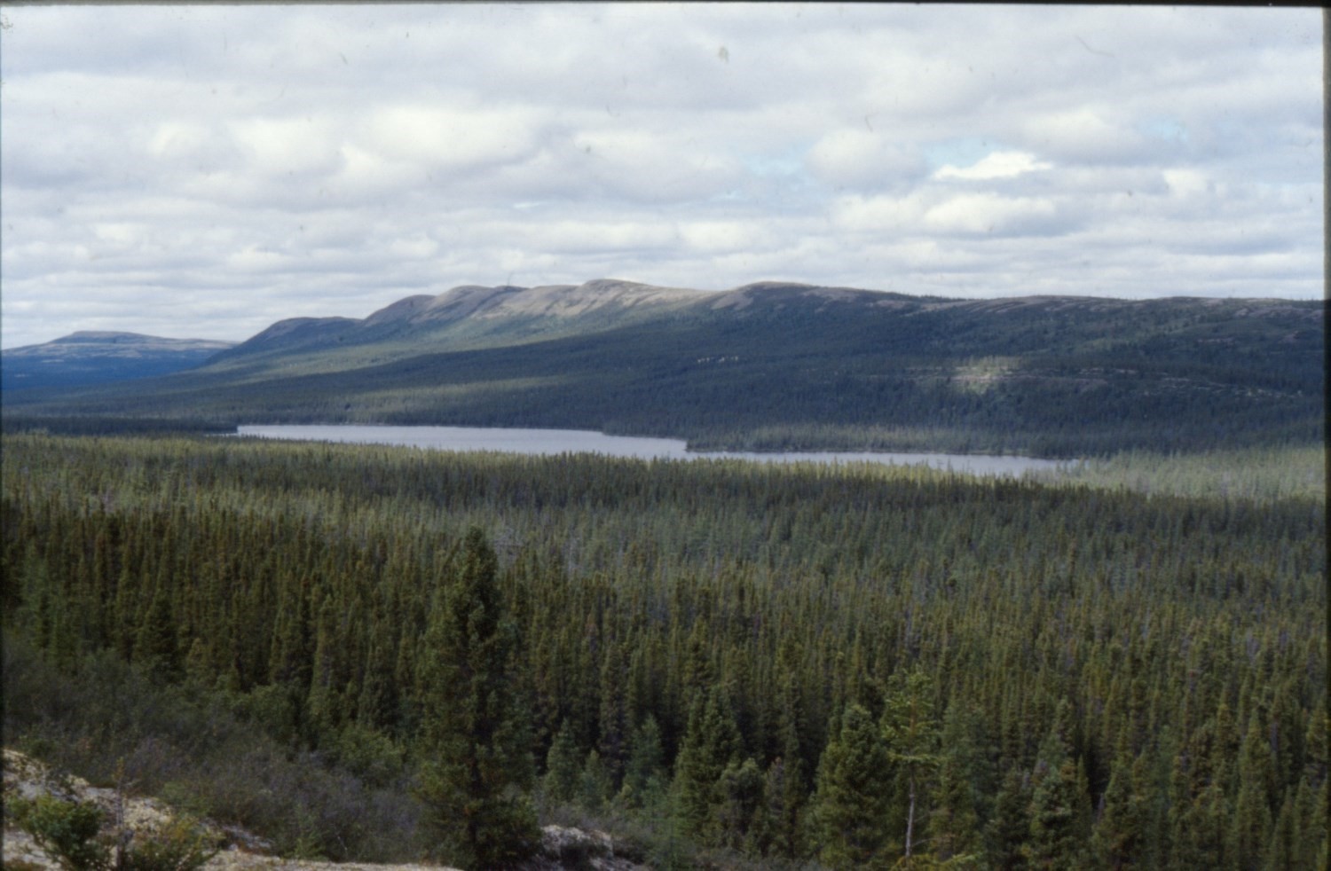
The Chioak Formation was identified between Feuilles Lake (latitude 58° 45′ N) to the north (Bérard, 1965) and Forbes Lake (latitude 57° 14′ N) to the south (Ciesielski, 1977; Clark, 1977, 1979) over a distance of ~170 km. Bérard (1965) mentions that the Chioak Formation may be present north of Feuilles Lake, but sparsely and of limited thickness. Consequently, Bérard did not individualize it on his geological map north of this lake. The Tamarack River Formation, located south of Schefferville, Labrador (Ware and Wardle, 1979; Ware, 1980), is homotaxial to the Chioak Formation. The Chioak and Tamarack River formations are part of the autochthonous/parautochthonous Bérard and Tamarack lithotectonic zones, respectively (Clark and Wares, 2004).
The Chioak Formation reaches a thickness of ~245 m south of Siugak (Chioak) Lake, although laterally the thickness varies considerably (Bérard, 1965). In the Napier Lake area (sheet 24E16), south of the area mapped by Bérard, the formation was divided into three members with thicknesses (from bottom to top) estimated to be <18 m, >23 m and >153 m, respectively, for a combined minimum thickness of 195 m (Clark, 1979). A thickness of ~195 m was also observed SE of the Aigneau River (sheet 24F05). The Tamarack River Formation was divided into four members and its total thickness was estimated at >395 m (Ware, 1980).
Dating
None.
Stratigraphic Relationship(s)
The Chioak Formation is Paleoproterozoic in age. It is younger than the Sokoman Formation, as conglomerate and sandstone beds of the Chioak Formation contain fragments from the latter. The Chioak Formation is therefore younger than 1880 Ma, which is the U-Pb age of a carbonatite dyke synchronous with the Sokoman Formation (Chevé and Machado, 1988). Rocks of the Chioak Formation were affected by the Hudsonian Orogenesis (Bérard, 1965; Clark, 1979). Geochronological work in different parts of the New Quebec Orogen revealed that deformation, partial melting and metamorphic events occurred between ˃1.84 and 1.77 Ga (Perreault et al., 1987; Machado et al., 1988, 1989; Machado, 1990; Perreault and Hynes, 1990; Wardleet al., 1990, 2002; James and Dunning, 2000; Simard et al., 2013; Davis et al., 2015). This age range represents the time during which the inner zone of the orogen collided with the Superior craton. Following an analysis of the Marralik-Tudor shear system located west of the De Pas Supersuite, Charette et al. (2016) concluded that dextral rifting in this area occurred during regional partial melting. Post-tectonic events in the Kuujjuaq area were dated between 1.77 and 1.74 Ga (Machado et al., 1988, 1989). Since the Chioak Formation is interpreted as synorogenic, its age would fall within the age range associated with continental collision, i.e. ˃1.84 to 1.77 Ga.
According to Bérard (1965), the Chioak Formation unconformably overlies Archean granitic bedrock and the Wishart and Sokoman formations of the Labrador Trough. In addition, a “paraconformity” was observed between the Chioak and Dragon formations (now assigned to the Menihek Formation; Clark and Wares, 2004), underlying the Chioak Formation locally (latitude 58° 15′ N; sheet 24L08). According to Clark (1979), south of latitude 58° N, the lower member of the Chioak Formation unconformably (erosional discordance) overlies Archean bedrock.
Bérard (1965) postulated the presence of a “paraconformity” between the Chioak Formation and the structurally overlying Abner Formation (now the Denault Formation; Clark and Wares, 2004). According to this author, the transition from detrital rocks of the Chioak Formation to chemically derived rocks of the Abner Formation is gradual, and includes the presence of intermediate lithofacies in the transition zone. For example, west of Garigue Lake (sheet 24L01), the author noted the presence of shale in the transition zone between the Chioak and Abner formations. In contrast, Clark (1979) identified a thrust fault that separates the upper member of the Chioak Formation from the Abner Formation south of latitude 58° N. Proposed evidence includes the presence of folds at the base of the Abner Formation, which produces cross-cutting of bedding in the Abner Formation through the contact between the formations, intense fracturing of the Chioak Formation beneath the Abner Formation, and cross-cutting of the different Chioak members through the lower contact of the Abner Formation. East of Imbault Lake (57° 56′ N; sheet 24E16), crushed rock is observed in the Chioak Formation immediately below the contact with the Abner Formation. Nearby, the Abner Formation overlies the Sokoman Formation in fault contact (Clark, 1979 and unpublished data).
The discovery of this fault relationship was of major importance in reinterpreting the stratigraphy and structure of the northern Labrador Trough (Clark and Wares, 2004). These authors noted (p. 11): “The discovery of a major thrust fault (the Garigue Fault) beneath the Abner Formation (Clark, 1979; Budkewitsch, 1986; Goulet, 1986), as well as the results of some U-Pb and Pb-Pb dating, have allowed the stratigraphy of the northern orogen to be reinterpreted (Fournier, 1985; Clark, 1988; Clark and Thorpe, 1990; Machado et al., 1997). The Abner Formation would thus be equivalent to the Denault Formation (Attikamagen Group) of the first cycle, observed in the southern orogen, as suggested by Hoffman and Grotzinger (1989) and supported by the fact that their carbon isotopic compositions are similar (Melezhik et al., 1997).”
Previous works (Dimroth, 1970; Dimroth et al., 1970) suggested that the Wishart and Sokoman formations are part of the second volcano-sedimentary cycle of the Labrador Trough, while the Abner Formation, the “Upper Iron formation” and the “Larch River slate” belong to a third volcano-sedimentary cycle. With this new interpretation, the Abner Formation (now the Denault Formation) is part of the first volcano-sedimentary cycle. The Chioak Formation, which thus occupies the top of the Trough stratigraphic column, is attributed to a third cycle (Hoffman, 1987, 1988; Clark and Wares, 2004).
Paleontology
Dolomite beds of the Chioak Formation locally exhibit cryptalgal and algal structures (stromatolites).
References
Publications Available Through SIGÉOM Examine
BERARD, J. 1965. REGION DU LAC BERARD, NOUVEAU-QUEBEC. MRN. RG 111, 175 pages and 2 plans.
BERARD, J. 1965. BERARD LAKE AREA, NEW QUEBEC. MRN. RG 111(A), 148 pages and 2 plans.
CIESIELSKI, A. 1975. CONTACT ARCHEEN-PROTEROZOIQUE ENTRE LES LACS FORBES ET SENAT (FOSSE DU LABRADOR) – RAPPORT PRELIMINAIRE. MRN. DPV 449, 28 pages and 1 plan.
CLARK, T. 1977. GEOLOGY OF THE FORBES LAKE AREA (NOUVEAU-QUEBEC). MRN. DPV 452, 19 pages and 1 plan.
CLARK, T. 1979. REGION DU LAC NAPIER (NOUVEAU-QUEBEC) – RAPPORT PRELIMINAIRE. MRN. DPV 663, 28 pages and 1 plan.
CLARK, T. 1987. STRATIGRAPHIE, PETROGRAPHIE ET PETROCHIMIE DE LA FORMATION DE FER DE BABY DANS LA REGION DU LAC HERODIER (FOSSE DU LABRADOR). MRN. ET 87-13, 44 pages..
CLARK, T., WARES, R. 2004. SYNTHESE LITHOTECTONIQUE ET METALLOGENIQUE DE L’OROGENE DU NOUVEAU-QUEBEC (FOSSE DU LABRADOR). MRNFP. MM 2004-01, 182 pages and 1 plan.
DAVIS, D W., MOUKHSIL, A., LAFRANCE, I., HAMMOUCHE, H., GOUTIER, J., PILOTE, P., TALLA TAKAM, F. 2015. DATATIONS U-PB DANS LES PROVINCES DU SUPERIEUR, DE CHURCHILL ET DE GRENVILLE EFFECTUEES AU JSGL EN 2012-2013. MERN. RP 2014-07, 56 pages.
FOURNIER, D. 1985. MINERALISATION DE LA PARTIE ORIENTALE DU GEOSYNCLINAL DU LABRADOR (GROUPE DE LAPORTE). MRN. ET 83-23, 57 pages and 4 plans.
GOULET, N. 1986. ETUDE TECTONIQUE ET STRATIGRAPHIQUE DE LA PARTIE NORD DE LA FOSSE DU LABRADOR – REGION DE LA BAIE AUX FEUILLES ET DU LAC BERARD. MRN. MB 86-27, 22 pages and 6 plans.
LAFRANCE, I., CHARETTE, B. 2015. Géologie de la région du lac Jeannin. MERN. BG 2015-01, 1 plan.
Other Publications
BUDKEWITSCH, P. 1986. A structural study of the Chioak-Abner formation contact, northern part of the Labrador Trough, New Quebec. Masters thesis, Université Concordia, Montréal; 61 pages.
CHEVÉ, S.R., MACHADO, N. 1988. Reinvestigation of the Castignon Lake carbonatite complex, Labrador Trough, New Québec. Joint Annual Meeting of the Geological Association of Canada and the Mineralogical Association of Canada, St. John’s, Newfoundland; Program with Abstracts, Volume 13, pages 20.
CLARK, T., THORPE, R.I. 1990. Model lead ages from the Labrador Trough and their stratigraphic implications. In The Early Proterozoic Trans-Hudson Orogen of North America: Lithotectonic Correlations and Evolution (J.F. Lewry, J.F. and M.R. Stauffer, editors). Geological Association of Canada; Special Paper 37, pages 413-432.
DIMROTH, E. 1970. Evolution of the Labrador Geosyncline. Geological Society of America Bulletin; Volume 81, pages 2717-2742. https://doi.org/10.1130/0016-7606(1970)81[2717:EOTLG]2.0.CO;2
DIMROTH, E., BARAGAR, W.R.A., BERGERON, R., JACKSON, G.D. 1970. The filling of the Circum-Ungava geosyncline. In: Symposium on Basins and Geosynclines of the Canadian Shield (A.J. Baer, editor). Geological Survey of Canada; paper 70-40, pages 45-142. https://doi.org/10.4095/124922
HOFFMAN, P. 1987. Early Proterozoic foredeeps, foredeep magmatism and Superior-type iron formations of the Canadian Shield. In Proterozoic Lithospheric Evolution (A. Kroner, editor). American Geophysical Union, Geodynamics Series; Volume 17, pages 85-98.
HOFFMAN, P. 1988. United Plates of America, the birth of a craton: Early Proterozoic assembly and growth of Proto-Laurentia. Annual Reviews of Earth and Planetary Sciences; Volume 16, pages 543-603. https://doi.org/10.1146/annurev.ea.16.050188.002551
HOFFMAN, P., GROTZINGER, J.P. 1989. Abner-Denault reef complex (2.1 Ga), Labrador Trough, N.E. Québec. In Reefs, Canada and Adjacent Area (H.H.J. Geldsetzer, N.P. James, and GE. Tebbutt, editors). Canadian Society of Petroleum Geologists; Memoir 13, pages 49-54.
JAMES, D.T., DUNNING, G.R. 2000. U-Pb geochronological constraints for Paleoproterozoic evolution of the Core Zone: southeastern Churchill Province, northeastern Laurentia. Precambrian Research; Volume 103, pages 31-54. https://doi.org/10.1016/S0301-9268(00)00074-7
MACHADO, N. 1990. Timing of collisional events in the Trans-Hudson Orogen: evidence from U-Pb geochronology for the New Quebec Orogen, the Thompson Belt and the Reindeer Zone (Manitoba and Saskatchewan). In The Early Proterozoic Trans-Hudson Orogen of North America: Lithotectonic Correlations and Evolution (J.F. Lewry and M.R. Stauffer, editors). Geological Association of Canada; Special Paper 37, pages 433-441.
MACHADO, N., PERREAULT, S., HYNES, A. 1988. Timing of continental collision in the Northern Labrador Trough, Quebec: evidence from U-Pb geochronology. Geological Association of Canada-Mineralogical Association of Canada, Annual meeting; Program and Abstracts, volume 13, page 76.
MACHADO, N., GOULET, N., GARIÉPY, C. 1989. U-Pb geochronology of reactivated Archean basement and of Hudsonian metamorphism in the northern Labrador Trough. Canadian Journal of Earth Sciences; Volume 26, pages 1-15. https://doi.org/10.1139/e89-001
MACHADO, N., CLARK, T., DAVID, J., GOULET, N. 1997. U-Pb ages for magmatism and deformation in the New Quebec Orogen. Canadian Journal of Earth Sciences; Volume 34, pages 716-723. https://doi.org/10.1139/e17-058
MELEZHIK, V.A., FALLICK, A.E., CLARK, T. 1997. Two billion year old isotopically heavy carbon: evidence from the Labrador Trough, Canada. Canadian Journal of Earth Sciences; Volume 34, pages 271-285 https://doi.org/10.1139/e17-025
PERREAULT, S., HYNES, A. 1990. Tectonic evolution of the Kuujjuaq terrane, New Quebec Orogen. Geoscience Canada; Volume 17, pages 238-240.
PERREAULT, S., HYNES, A., MOORHEAD, J. 1987. Metamorphism of the eastern flank of the Labrador Trough, Kuujjuaq, Ungava, Northern Quebec. Geological Association of Canada-Mineralogical Association of Canada, Annual meeting; Program and Abstracts, volume 12, page 80.
WARDLE, R.J., RYAN, B., NUNN, G.A.G., MENGEL, F.C. 1990. Labrador segment of the Trans-Hudson orogen: crustal development through oblique convergence and collision. In The Early Proterozoic Trans-Hudson Orogen of North America (J.F. Lewry and M.R. Stauffer, editors). Geological Association of Canada; Special Paper 37, pages 353-369.
WARDLE, R.J., JAMES, D.T., SCOTT, D.J., HALL, J. 2002. The southeastern Churchill Province: synthesis of a Paleoproterozoic transpressional orogen. Canadian Journal of Earth Sciences; Volume 39, pages 639-663. https://doi.org/10.1139/e02-004
WARE, M.J. 1980. Tamarack River Formation, Sims Lake – Menihek Lake area, western Labrador. In Current research (C.F. O’Driscoll and R.V. Gibbons, editors). Government of Newfoundland and Labrador, Department of Mines and Energy, Mineral Development Division; Report 80-01, pages 194-200. https://www.gov.nl.ca/iet/files/mines-geoscience-publications-currentresearch-1980-ware-cr1980.pdf
WARE, M.J., WARDLE, R.J. 1979. Geology of the Sims Lake – Evening Lake area, western Labrador, with emphasis on the Helikian Sims Group. Government of Newfoundland and Labrador, Department of Mines and Energy, Mineral Development Division; Report 79-5, 27 pages. https://gis.geosurv.gov.nl.ca/geofilePDFS/WBox040/LAB_0458.pdf
Suggested Citation
Ministère de l’Énergie et des Ressources naturelles (MERN). Chioak Formation. Quebec Stratigraphic Lexicon. https://gq.mines.gouv.qc.ca/lexique-stratigraphique/province-de-churchill/formation-de-chioak_en [accessed on Day Month Year].
Contributors
First publication | Thomas Clark, P. Geo., Ph.D. (redaction) Mehdi A. Guemache, P. Geo., Ph.D. (coordination); Charles St-Hilaire, GIT, M.Sc. (critical review); Simon Auclair, P. Geo., M.Sc. (editing); Céline Dupuis, P. Geo., Ph.D. (English version); Nathalie Bouchard and André Tremblay (HTML editing). |