

Last modified: 7 October 2022
DISCLAIMER: This English version is translated from the original French. In case of any discrepancy, the French version shall prevail.
| Author(s): | Verpaelst et al., 2000 |
| Age: | Archean |
| Stratotype: | None |
| Type area: | Koroc River area (NTS sheet 24I) |
| Geological province: | Churchill Province |
| Geological subdivision: | Falcoz Lithotectonic Domain |
| Lithology: | Orthogneiss |
| Category: | Lithodemic |
| Rank: | Complex |
| Status: | Formal |
| Use: | Active |
None
Background
The Sukaliuk Complex was introduced by Verpaelst et al. (2000) in the Koroc and Hebron River area (sheets 24I and 14L) to describe a package of orthogneiss, supracrustal rocks and mafic rocks for the most part metamorphosed to the granulite facies and part of the Torngat Orogen, i.e. the area east of the Blumath Shear Zone (ZCblm). Part of this complex was assigned to the Lomier Complex by Girard (1990) during 1:50,000 mapping of the Courdon Lake area (sheet 14E12). Granulitic rocks present west of the Pilliamet Shear Zone (ZCpil) were reassigned to the Sukaliuk Complex by Lafrance et al. (2015), as were the rocks mapped by Verpaelst et al. (2000) in the area located directly to the north.
Climatic conditions of the summer of 1998 limited the fieldwork and resulted in Verpaelst et al. (2000) not always being able to differentiate granulitic gneiss of the Sukaliuk Complex by composition. They had thus grouped much of the Sukaliuk Complex in an undifferentiated granulitic gneiss unit. This subdivision was not used by Lafrance et al. (2015, 2016) in the southbound extension as the work of these authors allowed the Sukaliuk Complex to be subdivided according to its dominant composition. Mapping in the summer of 2017 in the Koroc River and Hébron area, and staining of samples collected during the summers of 1998 and 2017 have helped to standardize the nomenclature of this unit based on its dominant composition (Mathieu et al., 2018), and to abandon the undifferentiated granulitic gneisses unit.
Subsequently, as part of a regional synthesis of the southeastern Churchill Province (SEPC; Lafrance et al., 2018), Lafrance and Vanier (2022) reassigned the metasedimentary rock units, anatectic granites, and mafic and ultramafic rocks previously included in the Sukaliuk Complex to the Lake Harbour (pPhb), Abrat (pPaba), and Nuvulialuk (pPnuv) suites respectively. These changes in nomenclature are detailed in the table below.
| Revised Units and Subunits (Lafrance et Vanier, 2022) | Previous Units and Subunits | References(s) |
|---|---|---|
| Asuk1 | ApPsuk2 | Lafrance et al., 2015, 2016 |
| ApPsuk1 | Verpaelst et al., 2000 | |
| Mathieu et al., 2018 | ||
| Asuk1a | ApPsuk2a | Lafrance et al., 2015, 2016 |
| ApPsuk1a | Mathieu et al., 2018 | |
| Asuk1b | ApPsuk1b | Mathieu et al., 2018 |
| Asuk2 | ApPsuk3 | Lafrance et al., 2015, 2016 |
| ApPsuk2 | Mathieu et al., 2018 | |
| ApPsuk1 | Verpaelst et al., 2000 | |
| Asuk2a | ApPsuk3a | Lafrance et al., 2015, 2016 |
| ApPsuk2a | Mathieu et al., 2018 | |
| pPnuv1a | ApPsuk6 | Lafrance et al., 2015, 2016 |
| ApPsuk3a | Mathieu et al., 2018 | |
| pPnuv1b | ApPsuk6a | Lafrance et al., 2015, 2016 |
| ApPsuk3b | Mathieu et al., 2018 | |
| pPnuv3 | ApPsuk3c | Mathieu et al., 2018 |
| pPnuv2a | ApPsuk4 | Verpaelst et al., 2000 |
| pPnuv2 | Lafrance et al., 2015 | |
| ApPsuk3d | Mathieu et al., 2018 | |
| pPhb1b | ApPsuk4 | Lafrance et al., 2015, 2016 |
| ApPsuk4a | Mathieu et al., 2018 | |
| pPhb2a | ApPsuk5 | Verpaelst et al., 2000 |
| ApPsuk4b | Mathieu et al., 2018 | |
| pPaba1a | ApPsuk4a | Lafrance et al., 2015, 2016 |
| ApPsuk5 | Mathieu et al., 2018 |
Description
The Sukaliuk Complex consists of two units: 1) a hypersthene tonalitic orthogneiss unit (Asuk1); and 2) a hypersthene granitic orthogneiss unit (Asuk2).
Sukaliuk Complex 1 (Asuk1): Hypersthene Tonalitic Orthogneiss

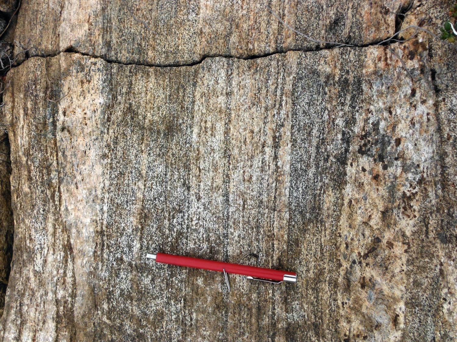
Unit ApPsuk1 is the main unit of the Sukaliuk Complex. The fine to medium-grained rock is characterized by a greenish grey colour on a fresh surface, typical of orthopyroxene rocks, and a whitish to light grey colour in altered surface. In thin section, it shows a well-developed even-grained granoblastic texture. Gneiss banding is often difficult to observe, especially on a fresh surface; however, stains highlight alternating millimetric to centimetric bands of tonalite and quartz diorite (12-25% quartz). This banding is also defined by the presence of a coarser-grained enderbitic or charnockitic phase. This phase forms diffuse bands, millimetric to centimetric, brown sugar in colour or lighter green. These bands could represent leucosomes, late intrusions, or the result of metamorphic segregation or metamorphic fluid circulation.
The gneiss is also intruded to varying degrees by enderbite or charnockite of the Inuluttalik Suite. These intrusions, similar to the leucocratic bands described above, are also in diffuse contact with the gneiss and are difficult to distinguish in outcrop. Sawed samples allow for a better distinction between the two phases. Gneiss contains between 1 and 25% stretched enclaves or centimetric to decimetric horizons of orthopyroxene diorite or granoblastic gabbronorite.
The Asuk1 gneiss contains 5 to 20% biotite and hypersthene. Green hornblende and clinopyroxene are also commonly observed, particularly in quartz diorite horizons. Biotite shows intense pleochroism from yellowish to dark brown-red. Hypersthene is usually fresh, in places altered to serpentine or transformed into a mixture of hornblende and actinolite. Smoked quartz forms bands or discontinuous millimetric rods. In thin section, it has a strong undulatory extinction. K-feldspar (≤5%) is observed locally in interstitial crystals. Opaque minerals (especially magnetite) and apatite are present (2-5%). Other accessory minerals (epidote, garnet, sphene, allanite, zircon and calcite) are observed in small amounts.
Coarser-grained bands observed in gneiss contain centimetric euhedral orthopyroxene and well-developed quartz rods, giving them a deformed leucosome appearance. Although evidence of partial melting has been extensively identified on the outcrops visited in the Sukaliuk Complex, little evidence of this process can be seen in thin section. It is possible that most of the partial melting textures were obliterated during deformation following migmatitization. The deformation style and absence of flow textures suggest that these units did not contain significant rheological contrast during the deformation event, excluding the possibility that a large proportion of leucosome was present at that time. A migmatitization episode likely occurred in the early stage of the Torngat Orogen, during which partial melting fluid extraction was effective. This explains the preservation of granulite facies paragenesis due to anhydrous conditions generated by liquid extraction (Charette, 2016).
Sukaliuk Complex 1a (Asuk1a): Tonalitic Orthogneiss

In some areas, the tonalitic gneiss does not contain hypersthene. Many of these gneisses occur within a shear zone. Metric levels of tonalitic gneiss are also interbedded in the orthopyroxene gneiss. The presence of this tonalitic gneiss can be caused by a retrogradation of the granulitic gneiss in the vicinity of structures that allowed the transport of hydrated fluids or by a variation in the composition of the protoliths. Some protoliths would not have allowed the formation of orthopyroxene, even in the granulite facies.
The gneiss composition of subunit Asuk1a varies from tonalite to quartz diorite. The rock is grey, non-magnetic and contains between 5 and 20% centimetric to decimetric enclaves or horizons of hornblende-biotite diorite. It also contains 5 to 15% bands or conformable centimetric dykes of coarser-grained pink granite. Quartz (10-25%) forms bands near deformation zones. Ferromagnesian minerals (7–20%) consist of brown biotite with hornblende and magnetite more locally. Accessory minerals are scarce and consist of K-feldspar, apatite, chlorite, epidote, hematite and zircon.
Sukaliuk Complex 1b (Asuk1b): Banded Granulitic Orthogneiss with Alternating Tonalitic and Granitic Bands
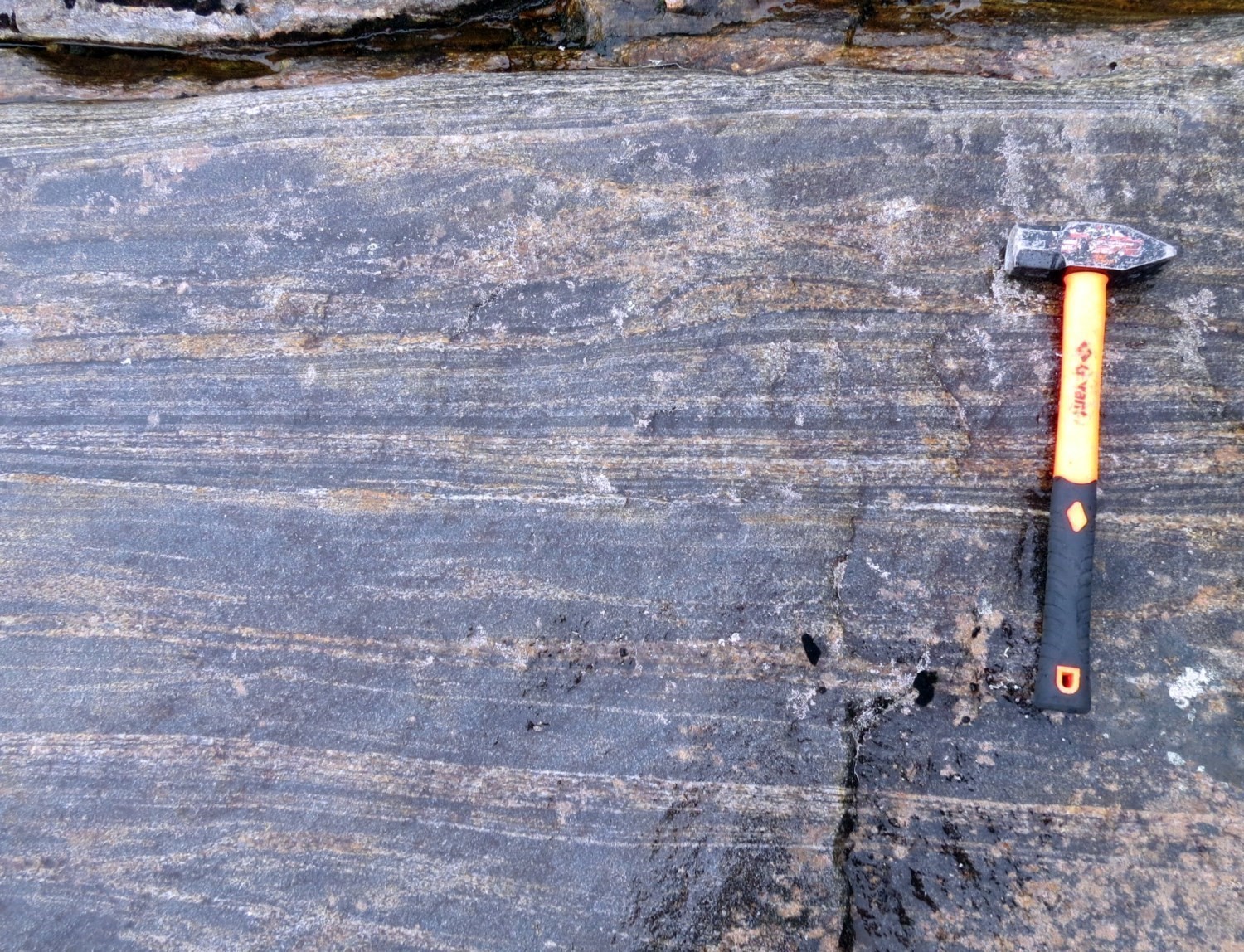
Subunit Asuk1b is a minor component of the Sukaliuk Complex. It is composed of orthopyroxene orthogneiss showing alternating millimetric to centimetric bands of either tonalitic or granitic composition. The grey-brown sugar colour on a fresh surface and the beige patina, regardless of the composition of bands, are characteristic. Only the variable proportion of ferromagnesian minerals (~5% for granitic bands and 10-25% for tonalitic bands) allows for individualization of band types in outcrop. Rocks of unit Asuk1b unit contain the same mineral phases and have the same textures as the Asuk1 unit.
Sukaliuk Complex 2 (Asuk2): Hypersthene Granitic Orthogneiss
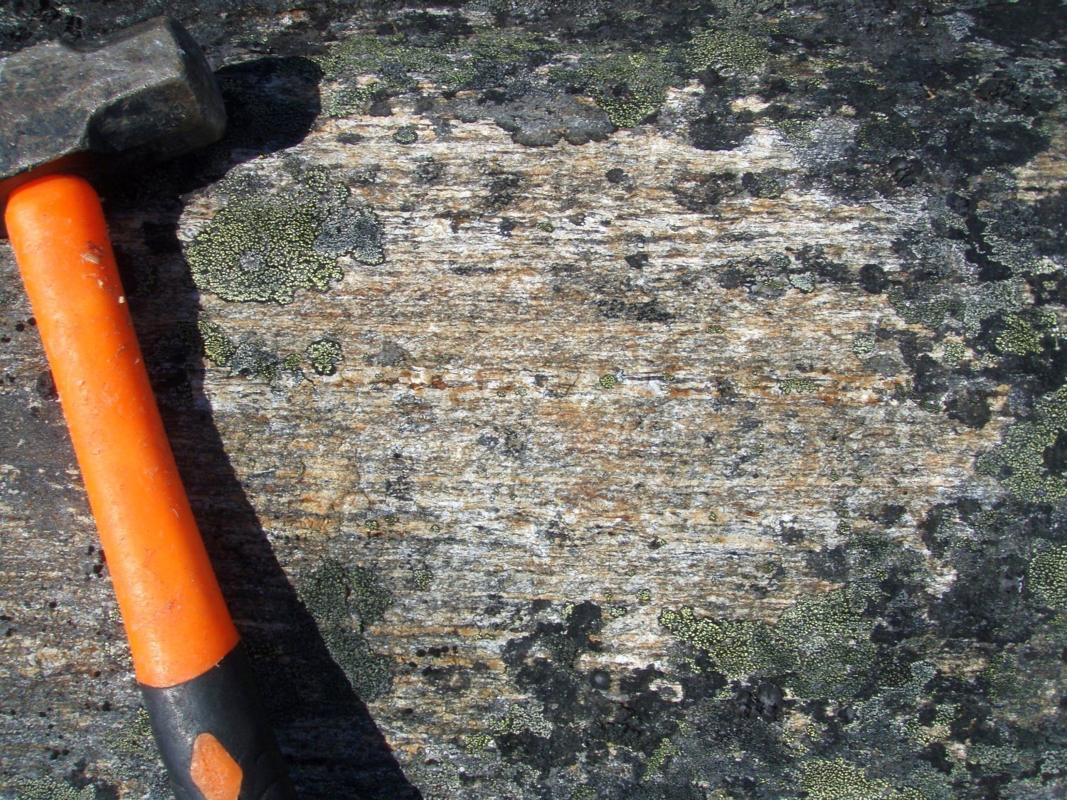
In outcrop, unit Asuk2 can be difficult to distinguish from unit Asuk1. Generally, the rock has slightly lighter green or brown sugar colour and contains few ferromagnesian minerals (5-10%). Stains highlight alternating granitic and granodioritic bands in gneiss. With the exception of K-feldspar, rocks of the Asuk2 unit contain the same mineral phases and have the same textures as the Asuk1 unit.
Sukaliuk Complex 2a (Asuk2a): Granitic Orthogneiss
Like unit Asuk1, unit Asuk2 also includes zones without orthopyroxene. These zones also appear to be associated with the presence of large shears in the vicinity. This granitic gneiss, similar to that observed in the Kangiqsualujjuaq Complex (Akan2), is finely recrystallized, light grey and contains 5 to 30% millimetric bands of pink granite, slightly coarser-grained but also granoblastic. It also contains 25-40% potassium feldspar, 20-25% quartz and 5-12% ferromagnesian minerals. The latter consist of brown biotite in places chloritized with, more locally, a lesser amount of green hornblende. The main accessory minerals are apatite and opaque minerals.
Thickness and Distribution
The Sukaliuk Complex forms a N-S strip 20 to 50 km wide followed over 325 km in length in the eastern part of the Falcoz Lithotectonic Domain. It covers an area of ~5078 km2 within this domain.
In general, the Asuk1 (~4319 km2) tonalitic orthogneiss unit represents the dominant facies. Unit Asuk2 (~318 km2) is concentrated on the western and eastern borders of the Sukaliuk Complex, where it forms strips of up to 7 km wide and 40 km long. Subunits Asuk1a (~3 km2) and Asuk2a (~174 km2) cover smaller areas and form lenticular strips, which are generally <2 km wide within the complex.
Dating
Dating of several tonalitic orthogneiss samples from unit Asuk1 (outcrops 2013-IL-3157, 2014-BC-6224, 2013-MP-0057, and 2013-SB-4161) yielded Archean ages for emplacement and Paleoproterozoic for metamorphism. The spread of Archean ages (3019 to 2622 Ma) indicates the existence of several generations of Archean zircons and reflects the complexity of this unit which contains several phases in diffuse contact. It thus seems to be a mixture of different magmas.
Paleoproterozoic ages of ~1911 Ma and ~1844 Ma correspond to metamorphism related to the Torngat Orogenesis (1885 to 1810 Ma; Charette, 2016; Charette et al., 2021). Paleoproterozoic ages <1800 Ma indicate high temperature conditions at this time, which appears consistent with the slow cooling phase of the Torngat Orogeny (Charette et al., 2021).
| Unit | Sample Number | Isotopic System | Mineral | Crystallization Age (Ma) | (+) | (-) | Inherited Age (Ma) | (+) | (-) | Metamorphic Age (Ma) | (+) | (-) | Reference(s) |
| Asuk1
| 2013-IL-3157A | U-Pb | Zircon | 2883 | 12 | 12 | – | – | – | 1768 | 52 | 52 | Corrigan et al., 2018 |
| 2014-BC-6224A | U-Pb | Zircon | 2718 | 7.9 | 7.9 | 2779 | 13 | 13 | 1783 | 25 | 25 | David, 2019 | |
| 2013-MP-0057A | U-Pb | Zircon | 2716 | 14 | 14 | 2802 3019 | 11 24 | 11 24 | 1844 | 5 | 5 | Davis et al., 2018 | |
| U-Pb | Monazite | 1911 | 8 | 8 | |||||||||
| Asuk1a | 2013-SB-4161A | U-Pb | Zircon | 2622 | 15 | 15 | 1718 | 98 | 98 | Corrigan et al., 2018 |
Stratigraphic Relationship(s)
The orthogneisses of the Sukaliuk Complex are cut by intrusive rocks of the Inuluttalik Suite and commonly contain decimetric to metric levels of metasedimentary, mafic, and ultramafic rocks of the Lake Harbour and Nuvulialuk Suites. It was difficult to distinguish the Sukaliuk Complex rocks from the Inuluttalik Suite rocks in the field due to the poor quality of the outcrops described (large lichen cover) and the similarity between the lithologies. Contact between the two units appears to be diffuse on a fresh surface; however, staining highlighted textural differences.
According to Lafrance et al. (2015), the Inuluttalik Suite may represent an evolved phase resulting from partial melting of rocks of the Sukaliuk Complex. This hypothesis is based on the close spatial association between the two units, as well as the presence of numerous biotite schlieren and centimetric to decimetric orthogneiss enclaves of the Sukaliuk Complex within intrusive rocks of the Inuluttalik Suite. The Sukaliuk Complex seems to be in sheared contact with the Kangiqsualujjuaq Complex to the west (ZCblm) and the Lomier Complex to the east (ZCpil).
Paleontology
Does not apply.
References
Publications Available through SIGÉOM Examine
DAVID, J., 2019. Datations U-Pb dans les provinces du Supérieur et de Churchill effectuées au GEOTOP en 2014-2015. MERN, GEOTOP; MB 2019-03, 24 pages.
DAVIS, D. W., LAFRANCE, I., GOUTIER, J., BANDYAYERA, D., TALLA TAKAM, F., GIGON, J., 2018. Datations U-Pb dans les provinces de Churchill et du Supérieur effectuées au JSGL en 2013-2014. MERN; RP 2017-01, 63 pages.
GIRARD, R., 1990. GEOLOGIE DE LA REGION DU LAC COURDON – TERRITOIRE DU NOUVEAU-QUEBEC. COMMISSION GEOLOGIQUE DU CAN; MB 90-24, 65 pages, 1 plan.
LAFRANCE, I., BANDYAYERA, D., BILODEAU, C., 2015. GEOLOGIE DE LA REGION DU LAC HENRIETTA (SNRC 24H). MERN; RG 2015-01, 62 pages, 1 plan.
LAFRANCE, I., BANDYAYERA, D., CHARETTE, B., BILODEAU, C., DAVID, J., 2016. GEOLOGIE DE LA REGION DU LAC BRISSON (SNRC 24A). MERN; RG 2015-05, 64 pages, 1 plan.
LAFRANCE, I., CHARETTE, B., VANIER, M.-A., 2018. Sud-est de la Province de Churchill, Nunavik, Québec, Canada: synthèse de la géologie. MERN; BG 2018-12
LAFRANCE, I., CHARETTE, B., VANIER, M.-A., 2018. Southeastern Churchill Province, Nunavik, Quebec, Canada: Geological Synthesis. MERN; BG 2018-12
LAFRANCE, I., VANIER, M.-A., 2022. Domaine lithotectonique de Falcoz, sud-est de la Province de Churchill, Nunavik, Québec, Canada : synthèse de la géologie. MERN; BG 2022-01, 2 plans.
MATHIEU, G., LAFRANCE, I., VANIER, M.-A., 2018. Géologie de la région de pointe Le Droit, Province de Nain et sud-est de la Province de Churchill, Nunavik, Québec, Canada. MERN; BG 2018-07, 4 plans.
MATHIEU, G., LAFRANCE, I., VANIER, M.-A., 2018. Geology of the Pointe Le Droit Region, Southeastern Churchill Province, Nunavik, Quebec, Canada. MERN; BG 2018-07, 4 plans.
VERPAELST, P., BRISEBOIS, D., PERREAULT, S., SHARMA, K. N. M., DAVID, J., 2000. Géologie de la région de la rivière Koroc et d’une partie de la région de Hébron, 24I et 14L. MRN; RG 99-08, 62 pages, 10 plans.
Other Publications
CHARETTE, B., 2016. Long-lived Anatexis in the Exhumed Middle Crust from the Torngat Orogen and Eastern Core Zone: Constraints from Geochronology, Petrochronology, and Phase Equilibria Modeling. University of Waterloo; thèse de maîtrise, 389 pages. uwspace.uwaterloo.ca/handle/10012/10453
CHARETTE, B., GODET, A., GUILMETTE, C., DAVIS, D.W., VERVOORT, J., KENDALL, B., LAFRANCE, I., BANDYAYERA, D., YAKYMCHUK, C., 2021. Long-lived anatexis in the exhumed middle crust of the Torngat Orogen: Constraints from phase equilibria modeling and garnet, zircon, and monazite geochronology. Lithos, volume 388-389. doi.org/10.1016/j.lithos.2021.106022
CORRIGAN, D., WODICKA, N., McFARLANE, C., LAFRANCE, I., VAN ROOYEN, D., BANDYAYERA, D., BILODEAU, C. 2018. Lithotectonic framework of the Core Zone, Southeastern Churchill Province. Geoscience Canada; volume 45, pages 1-24. doi.org/10.12789/geocanj.2018.45.128
Suggested Citation
Ministère de l’Énergie et des Ressources naturelles (MERN). Sukaliuk Complex. Quebec Stratigraphic Lexicon. https://gq.mines.gouv.qc.ca/lexique-stratigraphique/province-de-churchill/complexe-de-sukaliuk_en [accessed on Day Month Year].
Contributors
First Publication | Isabelle Lafrance, P.Geo., M.Sc. isabelle.lafrance@mern.gouv.qc.ca (redaction) Mehdi A. Guemache, P.Geo., Ph.D. (coordination); Claude Dion, Eng., M.Sc. (critical review); Simon Auclair, P.Geo., M.Sc. (editing); Céline Dupuis, P.Geo., Ph.D. (English version); Caroline Thorn (HTML editing). |
Revision(s) | Isabelle Lafrance, P.Geo., M.Sc. (redaction) Mehdi A. Guemache, P.Geo., Ph.D. (coordination); Marc-Antoine Vanier, Eng., M.Sc. (critical review); Simon Auclair, P. Geo., M.Sc. (editing); Dominique Richard, GIT, Ph.D. (English version); André Tremblay (HTML editing). |