

First published: 14 June 2019
Last modified:
DISCLAIMER: This English version is translated from the original French. In case of any discrepancy, the French version shall prevail.
| Author: | Clark, 1944 |
| Age: | Middle Ordovician |
| Stratotype: | Type section described by Clark (1952) at the Francon Quarry, formerly the National Quarries Company, in the Côte-Saint-Michel district (6.5 km north of Mount Royal) |
| Type area: | Montreal and surrounding areas (NTS sheet 31H) |
| Geological province: | St. Lawrence Platform |
| Geological subdivision: | St. Lawrence Lowlands Platform |
| Lithology: | Fine to medium-grained limestone with thin shale beds |
| Category: | Lithostratigraphic |
| Rank: | Member |
| Status: | Formal |
| Use: | Active |
- Trenton Group
- Tétreauville Formation
- Montréal Formation
- Rosemont Member
- Saint-Michel Member
- Neuville Formation
- Deschambault Formation
- Hull Formation
- Saint-Marc Formation
- Mile End Formation
- Ouareau Formation
- Fontaine Formation
- Pont-Rouge Formation
- Sainte-Anne Formation
- Galets Formation
- Shipshaw Formation
- Simard Formation
- Tremblay Formation
- René-Levasseur Formation
Background
The Saint-Michel Member was defined as the lower member of the Montréal Formation by Clark (1944, 1952). The name refers to the Côte-Saint-Michel district of the City of Montreal where the National Quarries Company type section was defined (Clark, 1952).
Description

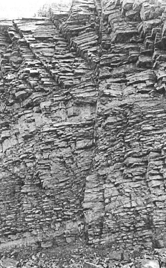
The Saint-Michel Member is composed primarily of fine to medium-grained limestone with thin shale interbeds (Clark, 1952, 1972; Brun, 1974, 1975; Harland and Pickerill, 1982; Globensky, 1981, 1986, 1987, 1993; MNRF, 2009b, d; Thériault, 2014). It is composed of a wide variety of lithologies (semi-crystalline, micritic or crystalline limestone), but typically consists of highly bioturbate crystalline limestone in thin, regular beds. It is particularly rich in bryozoa. The type section was described by Clark (1952) at the Francon Quarry, formerly of the National Quarries Company, in the Côte-Saint-Michel district (6.5 km north of Mount Royal):
| Saint-Michel Member | Top of cliff. | Thickness |
| Weathered beds with yellow or brown weathering products; with large Prasopora heads (10 cm in diameter); Parastrophia abundant in places. | 0.9 m | |
| Irregular beds of limestone and argillaceous schist; limestone beds 2.5-10 cm; argillaceous schist beds rarely >2.5 cm; argillaceous schist exhibit exceptional bryozoan abundance. | 7.6 m | |
| Regular beds of limestone, finely zoned, finely crystalline in places; tubes resembling Phytopsis common here and there. | 0.4 m | |
| Sill of basic rocks. | (0.8 m) | |
| Regular beds of limestone, finely zoned, finely crystalline in places; tubes resembling Phytopsis common here and there. | 0.5 m | |
| Limestones and argillaceous schists; limestone is more abundant and regularly stratified upward, approaching overlying regularly bedded limestones;sopora common in one or two beds. | 0.6 m | |
| Compact blue limestone; finely joint vertically; sparse fossils. | 0.3 m | |
| Grey limestone, crystalline, with very little argillaceous schists; abundant bryozoa, mainly in argillaceous partings; other fossils are sparse. | 1.4 m | |
| Compact limestone, crystalline, in 5-20 cm beds, with argillaceous partings up to 15 cm; bryozoa common everywhere. | 1.7 m | |
| Sill of basic rocks. | (0.4 m) | |
| Crystalline limestone, medium-grained, light grey, bitumem smell; sparse fossils. To the west of the fault that meets midway in the quarry wall, this bed is split by the sill that overlies it to the east of the fault. | 0.3 m | |
| Fine-grained crystalline limestone with argillaceous schists; limestone beds up to 30 cm thick; bryozoa abundant everywhere. | 4.6 m | |
| Fine-grained crystalline limestone, in 10-15 cm beds, with very irregular argillaceous that can reach 7.5 cm in thickness; bryozoa absent. | 2.6 m | |
| Compact limestone, well stratified, finely crystalline in places; abundant bryozoa. | 0.4 m | |
| Black argillaceous schists, rich in bryozoa. | 0.1 m | |
| Sill of basic rocks. | (0.1 m) | |
| Irregularly bedded limestone, altering to nodules, in 5-15 cm beds, with argillaceous partings reaching 5 cm; one Prasopora specimen. | 3.7 m | |
| Sill of basic rocks. | (1.1 m) | |
| Irregularly bedded limestone, altering to nodules, in 5-15 cm beds, with argillaceous partings reaching 5 cm; one Prasopora specimen. | 2.1 m | |
| Crystalline limestone, medium to fine-grained; sparse fossils. | 0.2 m | |
| Irregularly bedded limestone, altering to nodules, in 5-15 cm beds, with argillaceous partings reaching 5 cm in thickness; Cryptolithus common. | 0.9 m | |
| Alternating beds of limestone and argillaceous schist, well stratified and cross-bedded; limestone beds up to 15 cm and argillaceous schist beds up to 5 cm thick. | 1.0 m | |
| Dark limestone, fine-grained. | 0.15 m | |
| Crystalline limestone, grey, with thin argillaceous partings. | 0.6 m | |
| One sole bed of crystalline limestone, medium-grained, grey; sparse fossils. | 0.4 m | |
| Black argillaceous schists and limestones, in equal proportions; fossil-rich. It is the lowest bryozoa-rich horizon. | 0.2 m | |
| Base of Saint-Michel Member. | ||
| Total thickness of Saint-Michel Member, excluding sills: | 30.9 m |
From five sections (Miron Ltd. Company Quarry, Montreal; St-Vincent de Paul Quarry, St-Vincent-de-Paul; Sintra Quarry, St-Jacques; Ciments Indépendants Inc. Quarry, Joliette; Turnbull Construction Inc. Quarry, St-Thomas), Brun (1974, 1975) defined boundary stratotypes between the Deschambault Formation and the Saint-Michel Member of the Montréal Formation, as well as between the Saint-Michel and Rosemont members: “Deschambault-St-Michel boundary: Transition from a large ‘grainstone’ or ‘packstone’ limestone bed with steep-slope oblique laminations (Deschambault 3 [upper package]) to small regular beds of dark grey ‘mudstone’ limestone (St-Michel). St-Michel-Rosemont boundary: Gradual transition from alternating large, irregular, beige ‘grainstone’ and dark grey mudstone limestone (St-Michel) to alternating small, regular wavy beds of ‘wackestone’ and dark grey ‘mudstone’ limestone (Rosemont).”
Thickness and distribution
The Saint-Michel Member outcrops mainly between Joliette and Montreal and the best sections are found at Montreal quarries. Its thickness ranges from 30 to 40 m (Clark and Globensky, 1976a, b; Harland and Pickerill, 1982). The unit is also present in the Saint-Jean-sur-Richelieu area, south of Montreal.
Dating
None.
Stratigraphic Relationship(s)
In the greater Montreal and Joliette area, the Saint-Michel Member overlies the Deschambault Formation and is overlain by the Rosemont Member. The Saint-Casimir Member of the Neuville Formation, observed in areas more to the NW, can be correlated with the Saint-Michel Member (Globensky, 1987).
Paleontology
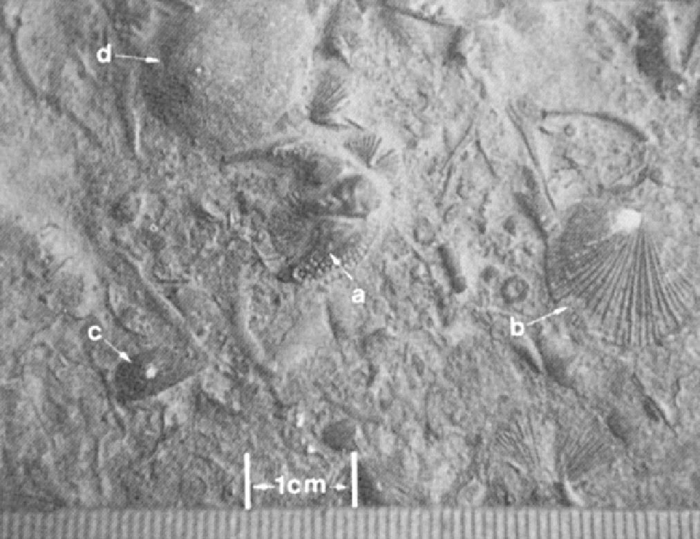

Abundant benthic fauna is present in the Saint-Michel Member, whose most representative fossils are trilobites Cryptolithus lorrentensis and C. tesselatus, and brachiopod Parastrophin hemiplicata (Clark, 1952, 1972; Globensky, 1981, 1987).
References
Publications Available Through SIGÉOM Examine
BRUN, J. 1974. ETUDE PETROGRAPHIQUE DES FORMATIONS DU BLACK RIVER ET DU TRENTON DU QUEBEC. MRN. DP 248, 24 pages and 4 plans.
BRUN, J. 1975. ETUDE GEOLOGIQUE ET GEOCHIMIQUE DES FORMATIONS DU BLACK RIVER ET DU TRENTON DU QUEBEC. MRN. DP 296, 45 pages and 4 plans.
CLARK, T H. 1952. MONTREAL AREA, LAVAL AND LACHINE MAPS AREAS. MRN. RG 046(A), 182 pages and 4 plans.
CLARK, T H. 1952. REGION DE MONTREAL, FEUILLES DE LAVAL ET DE LACHINE. MRN. RG 046, 189 pages and 4 plans.
CLARK, T H. 1972. REGION DE MONTREAL. MRN. RG 152, 260 pages and 1 plan.
CLARK, T H., GLOBENSKY, Y. 1975. REGION DE GRONDINES. MRN. RG 154, 171 pages and 1 plan.
CLARK, T H., GLOBENSKY, Y. 1976a. REGION DE SOREL ET PARTIE SUD-EST DE SAINT-GABRIEL-DE-BRANDON. MRN. RG 155, 166 pages and 1 plan.
CLARK, T H., GLOBENSKY, Y. 1976b. REGION DES LAURENTIDES (MOITIE EST) ET DE RAWDON (PARTIE SUD-EST). MRN. RG 157, 121 pages and 1 plan.
CLARK, T H., GLOBENSKY, Y. 1977. REGION DE VERCHERES. MRN. RG 190, 72 pages and 1 plan.
GLOBENSKY, Y. 1981. REGION DE LACOLLE – SAINT-JEAN (S). MRN. RG 197, 210 pages and 2 plans.
GLOBENSKY, Y. 1983. REGION DES LAURENTIDES (SW). MRN. MM 82-01, 42 pages and 1 plan.
GLOBENSKY, Y. 1986. GEOLOGIE DE LA REGION DE SAINT-CHRYSOSTOME ET DE LACHINE (SUD). MRN. MM 84-02, 182 pages and 2 plans.
GLOBENSKY, Y. 1987. GEOLOGIE DES BASSES-TERRES DU SAINT-LAURENT. MRN. MM 85-02, 71 pages and 1 plan.
GLOBENSKY, Y. 1993. LEXIQUE STRATIGRAPHIQUE CANADIEN – VOLUME V-B – REGION DES APPALACHES, DES BASSES-TERRES DU SAINT-LAURENT ET DES ILES DE LA MADELEINE. MRN. DV 91-23, 336 pages.
MRNF 2009a. GEOLOGIE 1/50 000, 31H05 – LACHINE. In: MRNF. 2010. CARTE(S) GÉOLOGIQUE(S) DU SIGEOM – feuillet 31h. CG SIGEOM31H, 22 plans.
MRNF 2009b. GEOLOGIE 1/50 000, 31H06 – SAINT-JEAN-SUR-RICHELIEU. In: MRNF. 2010. CARTE(S) GÉOLOGIQUE(S) DU SIGEOM – feuillet 31h. CG SIGEOM31H, 22 plans.
MRNF 2009c. GEOLOGIE 1/50 000, 31H12 – LAVAL. In: MRNF. 2010. CARTE(S) GÉOLOGIQUE(S) DU SIGEOM – feuillet 31h. CG SIGEOM31H, 22 plans.
MRNF 2009d. GEOLOGIE 1/50 000, 31H14 – VERCHÈRES. In: MRNF. 2010. CARTE(S) GÉOLOGIQUE(S) DU SIGEOM – feuillet 31h. CG SIGEOM31H, 22 plans.
THERIAULT, R. 2014. GEOLOGIE DES BASSES-TERRES DU SAINT-LAURENT. MERN. DV 2014-05, 1 plan.
Other Publications
CLARK, T.H. 1944. Structure and stratigraphy in the vicinity of Montréal. Transactions of the Royal Society of Canada; third series, volume 38, serie iv.
CLARK, T.H. 1959. Stratigraphy of the Trenton Group, St. Lawrence Lowlands, Quebec. Geological Association of Canada; proceedings 1959, pages 13–21.
HARLAND, T.L., PICKERILL, R.K. 1982. A review of Middle Ordovician sedimentation in the St. Lawrence Lowland, eastern Canada. Geological Journal; volume 17, pages 135–156. https://doi.org/10.1002/gj.3350170205