

First published: 14 June 2019
Last modified:
DISCLAIMER: This English version is translated from the original French. In case of any discrepancy, the French version shall prevail.
| Author: | Clark and Globensky, 1973, 1975, 1976 |
| Age: | Middle Ordovician |
| Stratotype: | Section of the Grondines and Saint-Casimir members along the shore of the St. Lawrence River upstream and downstream of the Neuville wharf (base of section 520 m east of wharf) described by Clark and Globensky (1973) |
| Type area: | Neuville area (NTS sheet 21L12) |
| Geological province: | St. Lawrence Platform |
| Geological subdivision: | St. Lawrence Lowlands Platform |
| Lithology: | Limestone with shale interbeds |
| Category: | Lithostratigraphic |
| Rank: | Member |
| Status: | Formal |
| Use: | Active |
- Trenton Group
- Tétreauville Formation
- Montréal Formation
- Neuville Formation
- Grondines Member
- Saint-Casimir Member
- Deschambault Formation
- Hull Formation
- Saint-Marc Formation
- Mile End Formation
- Ouareau Formation
- Fontaine Formation
- Pont-Rouge Formation
- Sainte-Anne Formation
- Galets Formation
- Shipshaw Formation
- Simard Formation
- Tremblay Formation
- René-Levasseur Formation
Background
Clark (1959) introduced the names “Neuville” and “Saint-Casimir” to define a section of the Trenton Group overlying the Deschambault Formation in the Neuville area (sheet 21L12). Thus presented, the “Saint-Casimir Formation” was overlying the Deschambault Formation and was overlain by the Neuville Formation. He suggested that, in the event of a division of the Neuville Formation, this term be kept for the Mid Trenton Group and that the term “Grondines” applies to the Upper Trenton Group. Clark and Globensky (1973, 1975, 1976) used the term “Neuville Formation” to define the lithology between the Deschambault Formation and the Utica Shale, and divided this formation into the Saint-Casimir Member (lower) and Grondines Member (upper). In a revision of the Neuville Formation, Globensky and Jauffred (1971) lowered the contact between the Saint-Casimir and Grondines members by 21 m at the type section along the St. Lawrence River. The name refers to the village of Grondines where the member outcrops along the St. Lawrence River (sheet 31I09).
Description
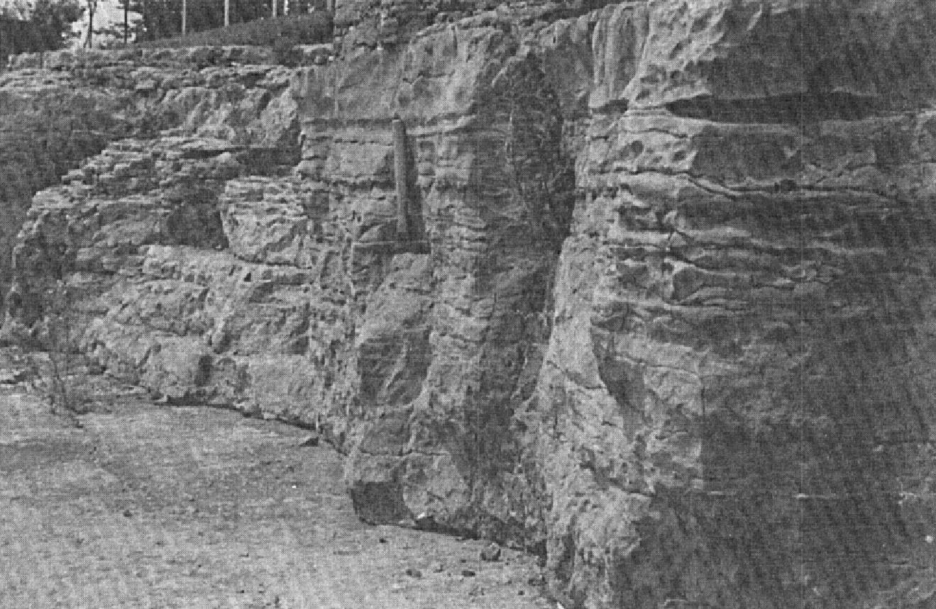


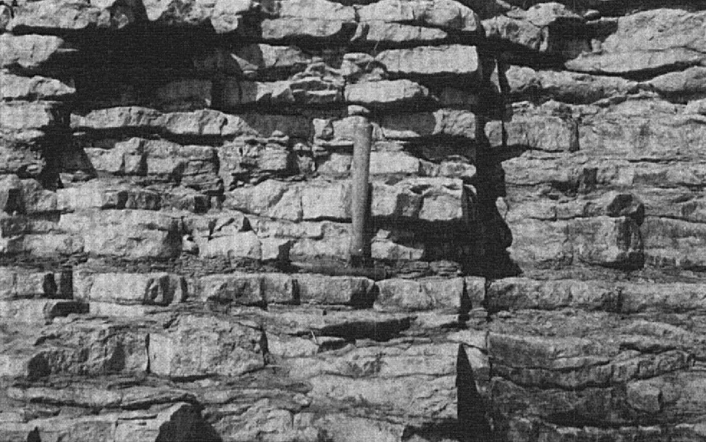
The Grondines Member consists typically of dark grey, dense, nodular, or irregular thick-bedded argillaceous and micritic limestone, and numerous dark shale interbeds (Clark and Globensky, 1973, 1975, 1976; Harland and Pickerill, 1982; Globensky, 1987). Light blue or grey chert is scattered throughout the member, particularly towards the upper part where chert is visible as veins on the surface of some beds. The lower and middle parts of the member alter from buff to yellow with plates or thin layers of crystalline fossil debris, probably crinoids or cystides.
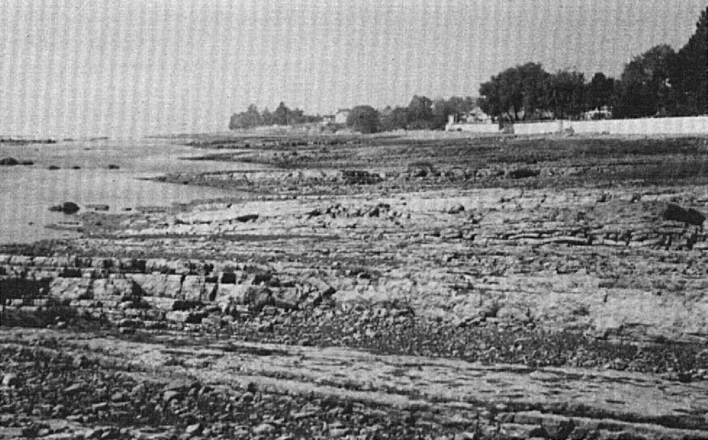
A section of the Grondines and Saint-Saint-Casimir members along the shore of the St. Lawrence River upstream and downstream of the Neuville wharf, whose base is located 520 m east of the wharf:
| Neuville Formation | Grondines Member | Top of the Grondines Member. | 111.2 m |
| Limestone made undulating by weathering. Abundant cephalopod fragments. | 111.2 m | ||
| Cherty limestone, frequent argillaceous partings. | 111.0 m | ||
| Dark argillaceous limestone in 5-10 cm beds with argillaceous partings 2.5 cm thick. | 101.2 m | ||
| Idem, but with argillaceous partings 2.5-7.5 cm thick. | 95.1 m | ||
| Lithographic limestone; sparse in the upper part of the section. | 90.6 m | ||
| Dark argillaceous limestone in 5-10 cm beds with argillaceous partings 2.5 cm thick. | 90.4 m | ||
| Nodular limestone in beds up to 5 cm. | 86.6 m | ||
| Crystalline limestone, coarse-grained, light grey. | 85.4 m | ||
| Nodular crystalline limestone, dark, thin and thick-bedded. | 85.3 m | ||
| Impure limestone, with a very irregular alteration surface. Rafinesquina deltoidea is frequent. | 84.1 m | ||
| Chemical limestone, pure, in 2.5-3.8 cm beds. | 79.7 m | ||
| Impure limestone in beds 5-15 cm thick. | 79.5 m | ||
| Dark limestone, with an irregular alteration surface. | 78.0 m | ||
| Thick-bedded limestone, up to 20 cm, with poorly defined argillaceous schist joints. | 77.3 m | ||
| Argillaceous limestone with thin argillaceous schist beds. Pure limestone beds are sparse. Large flat surfaces with the diving raft are at the top of this thickness. | 75.3 m | ||
| Mainly chemical limestone, with impure and nodular limestone forming a small cliff that contains a 53.3 cm thick bed. | 70.6 m | ||
| Mainly chemical limestone forming an uniform surafce in front of the hotel. | 68.0 m | ||
| Thin and thick-bedded limestone with argillaceous partings up to 7.5 cm thick. Beds become thinner towards the top and argillaceous partings less frequent. Numerous holes, Rafinesquina deltoides and R. alternata very frequent in a few beds. No type of pure chemical or crystalline limestone was observed. This sequence forms a 4.8 m high cliff. | 65.2 m | ||
| Limestone outcropping mostly as thin beds on the shore. | 60.4 m | ||
| Brecciated bed. Beds above and below are not affected. | 53.2 m | ||
| Almost pure limestone with thin argillaceous partings. At the top of this thickness is a large area dipping westward. | 52.9 m | ||
| Impure crystalline limestone, argillaceous with flaky alteration. | 50.9 m | ||
| Almost pure chemical limestone with some argillaceous partings. | 49.5 m | ||
| Dark grey lithographic limestone. | 46.5 m | ||
| Impure limestone in beds 5-7.5 cm thick with argillaceous partings 5 cm thick, brownish alteration. | 46.3 m | ||
| Cherty limestone, shattering fractures. | 43.0 m | ||
| Cherty limestone in beds 5-7.5 cm thick; one 15 cm thick bed of argillaceous schist. | 42.1 m | ||
| Impure limestone, with argillaceous partings 2.5-5 cm thick. | 40.8 m | ||
| Impure limestone, nodular, dark, fine-grained, in beds 5 cm thick. Highly fossiliferous. Well exposed at the top of the shore at low tide. Less visible when swept by tide. Cryptolithus triplecia nuclea are Ceraurus pleurexanthèmus lorettenesis are particularly abundant. | 39.7 m | ||
| Limestone in 15 cm thick beds. Nodular appearence probably caused by original deposition. | 38.9 m | ||
| Almost lithographic limestone in beds 5-7.5 cm thick with argillaceous partings 2.5-5 cm thick. | 37.9 m | ||
| Schistose limestone containing Cryptolithus. Base of the Cryptolithus lorettensis zone of the Grondines Member. | 36.8 m | ||
| Missing. | 36.5 m | ||
| Fine-grained grey limestone, thin-bedded. | 36.2 m | ||
| Fossiliferous limestone, crystalline, coarse-grained, grey, thick-bedded. | 35.4 m | ||
| Missing. | 35.1 m | ||
| Crystalline limeatone, nodular, dark grey. | 34.1 m | ||
| Missing. | 33.1 m | ||
| Bownish lithographic limestone with very thin argillaceous partings. Here and there, thin beds of crystalline and fossiliferous limestone. | 32.6 m | ||
| Base of the section west of wharf. Top of section east of wharf. | 26.8 m | ||
| Grey to dark grey chemical limestone. | 26.8 m | ||
| Schistose limestone forming thick (15 cm) and thin (5 cm) beds with argillaceous partings. Lithographic limestone beds are present. | 25.5 m | ||
| Dark crystalline and argillaceous limestone. | 23.9 m | ||
| Idem with interstratified fine-grained lithographic limestone. | 23.2 m | ||
| Thick bed of fine-grained limestone. | 21.0 m | ||
| Thin-bedded limestone, highly altered. | 18.3 m | ||
| Thick-bedded limestone. | 15.8 m | ||
| Brown limestone and argillaceous schist, interstratified in beds 5-20 cm thick. | 12.5 m | ||
| Saint-Casimir Member | Crystalline limestone, fine-grained, dark grey, small amount of brownish limestone. | 11.9 m | |
| Impure limestone, crystalline, fine-grained, dark grey. | 9.8 m | ||
| Almost lithographic limestone with a few crystalline limestone beds 1.3 cm thick. | 9.2 m | ||
| Crystalline limestone, very fine-grained, dark, with a few lithographic limestone beds. | 7.1 m | ||
| Lithographic limestone with a few argillaceous partings. | 4.4 m | ||
| Crystalline limestone, fine-grained, dark. | 3.8 m | ||
| Base of the section measured, 518 m eat of the Neuville wharf. | 0.0 m |
Another section of the Grondines Member is described in detail by Clark and Globensky (1975) on the shore of Grondines (sheet 31I09); it is not shown here. Sediments of the Grondines Member are interpreted as distant storm beds that have accumulated in a relatively deep marine environment of low energy and unaffected by waves (Harland and Pickerill, 1982; Globensky, 1993).
Thickness and distribution
The Grondines Member may be observed north of the St. Lawrence River, in the Portneuf (sheet 31I09), Pont-Rouge and Neuville (sheets 21L12 and 21L13), and Quebec City and Beaupré (sheet 21L14) areas. In the various sections described, its thickness varies from 66 to 100 m (Clark and Globensky, 1973, 1975).
Dating
None.
Stratigraphic Relationship(s)
The Grondines Member is the upper unit of the Neuville Formation, overlying the Saint-Casimir Member. The presence of Cryptolithus lorettensis and Rafinesquina deltoidea at the base of the Grondines Member indicates that the latter was completely deposited during the Cobourg and can be correlated with the Tétreauville Formation in the greater Montreal area (Globensky, 1987, 1993).
Paleontology
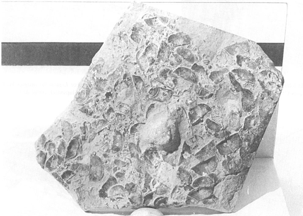
The fauna of the Grondines Member, like that of the Tétreauville Formation, is abundant and includes about 200 species of fossils (Clark and Globensky, 1973, 1975; Globensky, 1987). The two most important species constitute two biozones, with their full suite of other species: Rafinesquina deltoidea (brachiopod) zone and Cryptolithus lorettensis (trilobite) zone (Globensky, 1987).
References
Publications Available Through SIGÉOM Examine
BILODEAU, C., BRUN, J. 2000a. GEOLOGIE 1/20 000, 21L12-200-0201 – PORTNEUF. In : MRNF. 2010. CARTE(S) GÉOLOGIQUE(S) DU SIGEOM – feuillet 21l. CG SIGEOM21L, 43 plans.
BILODEAU, C., BRUN, J. 2000b. GEOLOGIE 1/20 000, 21L12-200-0202 – DONNACONA. In : MRNF. 2010. CARTE(S) GÉOLOGIQUE(S) DU SIGEOM – feuillet 21l. CG SIGEOM21L, 43 plans.
BILODEAU, C., BRUN, J. 2001. GEOLOGIE 1/50 000, 21L13 – SAINT-RAYMOND. In : MRNF. 2010. CARTE(S) GÉOLOGIQUE(S) DU SIGEOM – feuillet 21l. CG SIGEOM21L, 43 plans.
BRUN, J. 1974. ETUDE PETROGRAPHIQUE DES FORMATIONS DU BLACK RIVER ET DU TRENTON DU QUEBEC. MRN. DP 248, 24 pages and 4 plans.
BRUN, J. 1975. ETUDE GEOLOGIQUE ET GEOCHIMIQUE DES FORMATIONS DU BLACK RIVER ET DU TRENTON DU QUEBEC. MRN. DP 296, 45 pages and 4 plans.
CLARK, T H., GLOBENSKY, Y. 1973. PORTNEUF AND PARTS OF SAINT-RAYMOND AND LYSTER MAPS ARES, PORTNEUF AND LOTBINIERE COUNTIES. MRN. RG 148(A), 112 pages and 1 plan.
CLARK, T H., GLOBENSKY, Y. 1973. REGION DE PORTNEUF ET PARTIES DE ST-RAYMOND ET DE LYSTER, COMTES DE PORTNEUF ET DE LOTBINIERE. MRN. RG 148, 117 pages and 1 plan.
CLARK, T H., GLOBENSKY, Y. 1975. REGION DE GRONDINES. MRN. RG 154, 171 pages and 1 plan.
CLARK, T H., GLOBENSKY, Y. 1976. REGION DE TROIS-RIVIERES. MRN. RG 164, 94 pages and 1 plan.
GLOBENSKY, Y. 1987. GEOLOGIE DES BASSES-TERRES DU SAINT-LAURENT. MRN. MM 85-02, 71 pages and 1 plan.
GLOBENSKY, Y. 1993. LEXIQUE STRATIGRAPHIQUE CANADIEN – VOLUME V-B – REGION DES APPALACHES, DES BASSES-TERRES DU SAINT-LAURENT ET DES ILES DE LA MADELEINE. MRN. DV 91-23, 336 pages.
HÉBERT, C., BILODEAU, C. 1999a. GEOLOGIE 1/20 000, 21M07-200-0202 – BAIE-SAINT-PAUL. In : MRNF. 2010. CARTE(S) GÉOLOGIQUE(S) DU SIGEOM – feuillet 21m. CG SIGEOM21M, 23 plans.
HÉBERT, C., BILODEAU, C. 1999b. GEOLOGIE 1/20 000, 21M09-200-0101 – SAINT-HILARION. In : MRNF. 2010. CARTE(S) GÉOLOGIQUE(S) DU SIGEOM – feuillet 21m. CG SIGEOM21M, 23 plans.
HÉBERT, C., BILODEAU, C. 1999c. GEOLOGIE 1/20 000, 21M09-200-0102 – SAINT-IRENEE. In : MRNF. 2010. CARTE(S) GÉOLOGIQUE(S) DU SIGEOM – feuillet 21m. CG SIGEOM21M, 23 plans.
HÉBERT, C., BILODEAU, C. 1999d. GEOLOGIE 1/20 000, 21M09-200-0201 – NOTRE-DAME-DES-MONTS. In : MRNF. 2010. CARTE(S) GÉOLOGIQUE(S) DU SIGEOM – feuillet 21m. CG SIGEOM21M, 23 plans.
HÉBERT, C., BILODEAU, C. 1999e. GEOLOGIE 1/20 000, 21M09-200-0202 – LA MALBAIE. In : MRNF. 2010. CARTE(S) GÉOLOGIQUE(S) DU SIGEOM – feuillet 21m. CG SIGEOM21M, 23 plans.
LACOSTE, P., HÉBERT, C., BILODEAU, C. 1999. GEOLOGIE 1/50 000, 21M08 – ILES AUX COUDRES. In : MRNF. 2010. CARTE(S) GÉOLOGIQUE(S) DU SIGEOM – feuillet 21m. CG SIGEOM21M, 23 plans.
MRNF 2009a. GEOLOGIE 1/50 000, 31I02 – YAMASKA. In : MRNF. 2010. CARTE(S) GÉOLOGIQUE(S) DU SIGEOM – feuillet 31i. CG SIGEOM31M, 16 plans.
MRNF 2009b. GEOLOGIE 1/50 000, 31I07 – TROIS-RIVIÈRES. In : MRNF. 2010. CARTE(S) GÉOLOGIQUE(S) DU SIGEOM – feuillet 31i. CG SIGEOM31M, 16 plans.
MRNF 2009c. GEOLOGIE 1/50 000, 31I08 – BÉCANCOUR. In : MRNF. 2010. CARTE(S) GÉOLOGIQUE(S) DU SIGEOM – feuillet 31i. CG SIGEOM31M, 16 plans.
MRNF 2009d. GEOLOGIE 1/50 000, 31I09 – GRONDINES. In : MRNF. 2010. CARTE(S) GÉOLOGIQUE(S) DU SIGEOM – feuillet 31i. CG SIGEOM31M, 16 plans.
Other Publications
CLARK, T.H. 1959. Stratigraphy of the Trenton Group, St. Lawrence Lowlands, Quebec. Geological Association of Canada; proceedings 1959, pages 13-21.
GLOBENSKY, Y., JAUFFRED, J.C.N. 1971. Stratigraphic distribution of conodonts in the Middle Ordovician Neuville section of Quebec. Geological Association of Canada, proceedings; volume 23, pages 43-68.
HARLAND, T.L., PICKERILL, R.K. 1982. A review of Middle Ordovician sedimentation in the St. Lawrence Lowland, eastern Canada. Geological Journal; volume 17, pages 135-156. https://doi.org/10.1002/gj.3350170205