

Last modified:
Translation of original French
None
| Author: | Desbiens and Lespérence, 1989 |
| Age: | Upper Ordovician (Maysvillian) |
| Reference section: | Village of Mashteuiatsh, at Pointe-Bleue |
| Type area: | Southwestern shore of Lake Saint-Jean (NTS sheet 32A09) |
| Geological province: | St. Lawrence Platform |
| Geological subdivision: | St. Lawrence Lowlands Platform |
| Lithology: | Shale, limestone, conglomeratic to argillaceous calcarenite |
| Type: | Lithostratigraphic |
| Rank: | Formation |
| Status: | Formal |
| Use: | Active |
None
Background
Desbiens and Lespérence (1989) introduced the Pointe-Bleue Shales (formation rank) to distinguish this unit from the Gloucester, Macastry and Utica shales. Exploration to determine the hydrocarbon potential of shales in the Lake Saint-Jean area correlated the Pointe-Bleue Shales with the Utica Shale, although of Middle Ordovician age, for their bituminous character (Les Mines J.A.G., 2008). This unit is referred to as Pointe-Bleue Shales by some authors (Desbiens and Lespérence, 1989; Lavoie and Asselin, 1998) and Pointe-Bleue Formation by others (e.g., Hamblin, 2006). Moukhsil and Daoudene (2019) opted for the second term, given its variable lithology that includes shales and limestones. This Upper Ordovician formation outcrops in the Grenville Province, far from the St. Lawrence Platform.
Description
The Pointe-Bleue Formation consists of black graptolitic calcareous shale and greyish limestone. In the reference section in the village of Mashteuiatsh (Pointe-Bleue), the lower 7 cm consists of laminar shale, conglomeratic to argillaceous calcarenite containing angular fragments of shale, limestone with colonial pelmatozoa and some nodular limestone.
Thickness and Distribution
The thickness of the Pointe-Bleue Formation is mainly estimated by drilling, although it did not cut the upper part of the sequence (Desbiens and Lespérence, 1989). In the Chambord area, Riva (1969) mentions a thickness of 30 m and Benoit and Valiquette (1971) cite a thickness of 56 m for the underlying limestones. Desbiens and Lespérence (1989) reported a measured thickness of 14.8 m in the reference section of the Pointe-Bleue Formation.
Dating
None.
Stratigraphic Relationship(s)
The Pointe-Bleue Formation overlies and covers the Galets Formation. Contact between the two units was observed along the shoreline of Lake Saint-Jean near the village of Mashteuiatsh (Pointe-Bleue), along the Shipshaw River at Chute-aux-Galets and north of the Niobec Mine (Desbiens et Lespérence, 1989). At the Chute-aux-Galets dam, the transition between the underlying limestones and the overlying graptolitic shales is not gradual. This contact is of flash flood sedimentary nature with angular clasts. This involves a turbulent change in sedimentation within a continuous sequence. According to Desbiens and Lespérence (1989), this change corresponds to a significant increase in water depth compared to the shallow sequence of the Galets and Shipshaw formations.
Paleontology
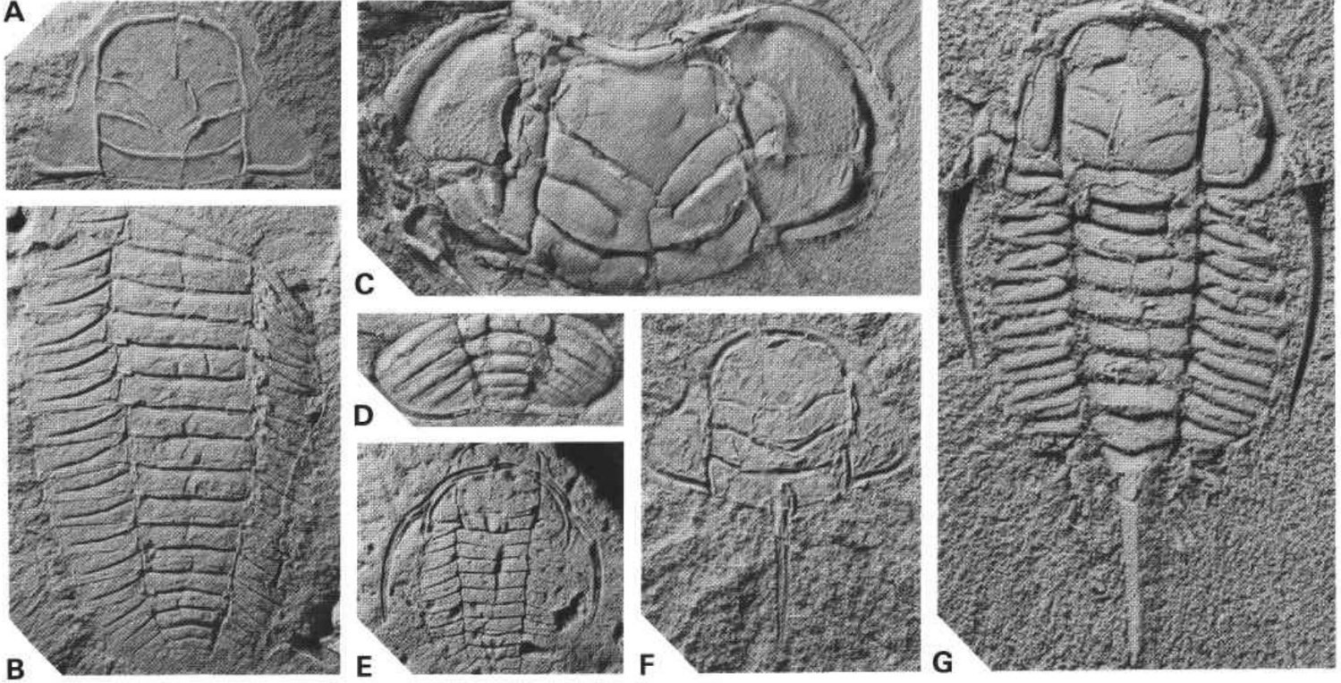
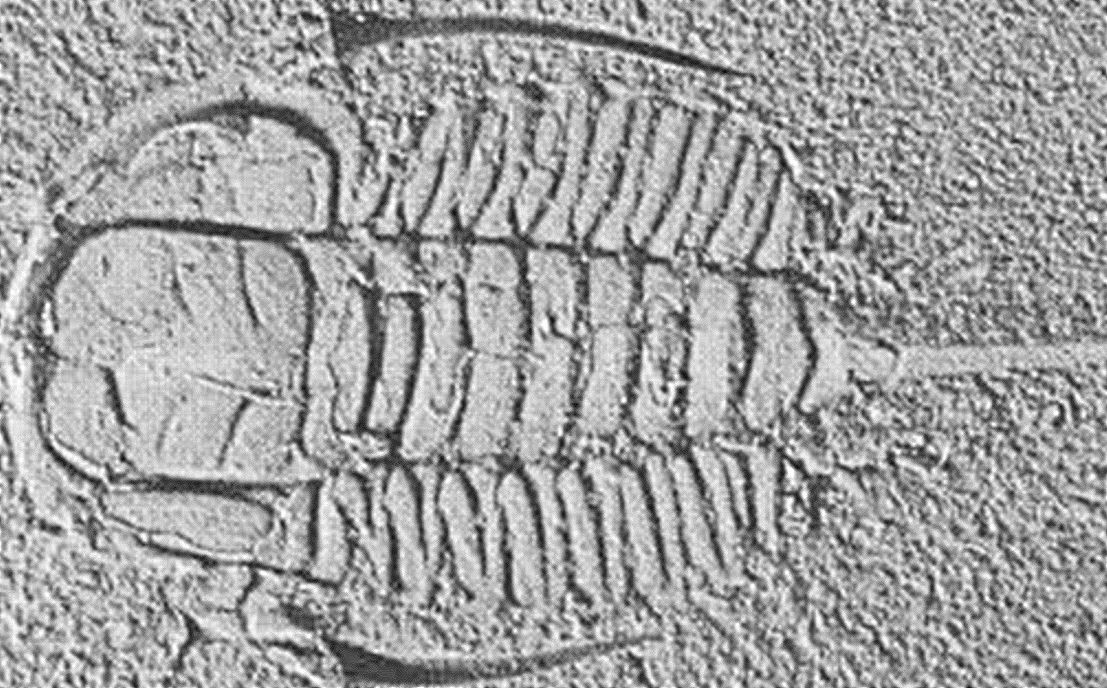
The main fossils found in this formation are trilobites (Triarthrus eatoni,Triarthrus glaber, Triarthrus rougensis, Triarthrus spinosus; Desbiens and Lespérence, 1989) which indicate an Upper Ordovician age (Maysvillian, 453-447.5 Ma; Asselin et al., 1996).
References
| Author(s) | Title | Year of Publication | Hyperlink (EXAMINE or Other) |
|---|---|---|---|
| ASSELIN, E. – ACHAB, A. – LAVOIE, D. | Upper Ordovician chitinoza from the Lac Saint-Jean outlier, Laurentian craton of eastern Canada IX Int. Palyno. Cong. Huston, page 7, Abstract. | 1996 | – |
| DESBIENS, S. – LESPÉRENCE, P.J. | Stratigraphy of the Ordovician of the Lac Saint-Jean and Chicoutimi outliers, Quebec. Canadian Journal of Earth Sciences, volume 26, pages 1185-1202. | 1989 | Source |
| BENOIT, F.W. – VALIQUETTE, G. | Région du lac Saint-Jean (partie sud). Ministère des Richesses naturelles, Québec. RG 140, 29 pages. | 1971 | RG140 |
| HAMBLIN, A. P. | The “Shale Gas” concept in Canada: a preliminary inventory of possibilities. Geological Survey of Canada, Open File 5384, 108 pages | 2006 | Source |
| LAVOIE, D. – ASSELIN, E. | Upper Ordovician facies in the Lac Saint-Jean outlier, Québec (eastern Canada): paleoenvironmental significance for Late Ordovician oceanography. Sedimentology. 45, pages 817-832. | 1998 | Source |
| MOUSHKIL, A. – DAOUDENE, Y. | Géologie de la région du lac des Commissaires, Province de Grenville, région du Saguenay–Lac-Saint-Jean, Québec, Canada. Ministère de l’Énergie et des Ressources naturelles, Québec; BG 2019-01. | 2019 | BG 2019-01 |
| RIVA, J. | Middle and Upper Ordovician graptolite faunas of St. Lawrence Lowlands of Quebec, and of Anticosti Island. In North Atlantic-geology and continental drift. Edited by M. Kay. American Association of Petroleum Geologists, Memoir 12, page 513-566. | 1969 | – |
| LES MINES J.A.G. | Propriété Lac St-Jean-Des résultats très prometteurs pour le gaz et le pétrole. Site web de la compagnie, communiqué de press du 12 novembre 2008 [cité le 14 septembre 2018]. | 2008 | – |