


Geology of the Normandin Area, Grenville Province, Saguenay–Lac-Saint-Jean Region, Quebec, Canada
Project for sheets 32A09, 32A10, 32A15, 32A16
Abdelali Moukhsil and Mhamed El Bourki
BG 2020-01
Published 19 November 2019 (original French version)


In Essence
A new 1:50 000 scale geological map of the Saguenay-Lac-Saint-Jean region (Roberval-Saint-Félicien-Normandin) was produced following a survey conducted in the summer of 2019. The map features mostly Mesoproterozoic stratigraphic units (0.99-1.45 Ga). Mainly felsic, intermediate, mafic to ultramafic intrusive suites, as well as metasedimentary (paragneiss, migmatitic paragneiss, migmatite, marble, calcosilicate rocks) to metavolcanic complexes are found. Also, a sequence of Ordovician sedimentary rocks, which lie unconformably on Mesoproterozoic rocks, has been mapped on the west shore of Lake Saint-Jean. Mesoproterozoic rocks are generally deformed, folded and cut by several faults (normal or reverse) and by shear zones (sinistral or dextral strike-slip). The structural grain is mainly oriented N-S to NE-SW. Regional prograde metamorphism extends from the upper amphibolite facies to the granulite facies. Locally, retrograde metamorphism has also been observed. A kilometric hydrothermal alteration system, consisting of zinc-mineralized volcano-sedimentary rocks, has been mapped in the NW part of the region. This system comprises several lithologies: rusty graphite-sillimanite paragneiss, quartzite containing traces of graphite, garnetite, calcosilicate rocks, marble, garnet-rich quartzofeldspathick rocks and fine-grained mafic rocks (metavolcanics). The region has several prospective zones for the exploration of mineral substances, which are grouped into four types:
- i) Zn ± Cu ± Ag mineralization in graphite-garnet-sillimanite metasedimentary rocks;
- ii) REE ± Th ± Nb ± Ta mineralization in granitic dykes and in syenitic and alkali feldspar granitic intrusions;
- iii) P ± Fe ± Ti mineralization in gabbronorite;
- iv) Cu ± Ni mineralization in ultramafic intrusive rocks.
Methodology
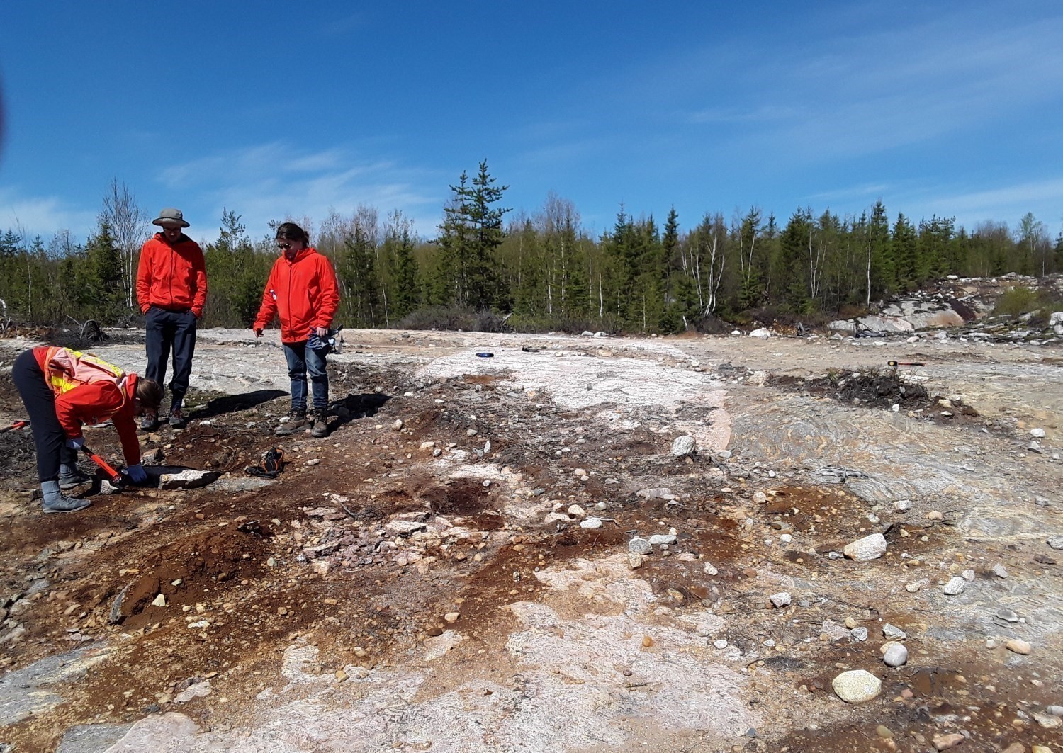
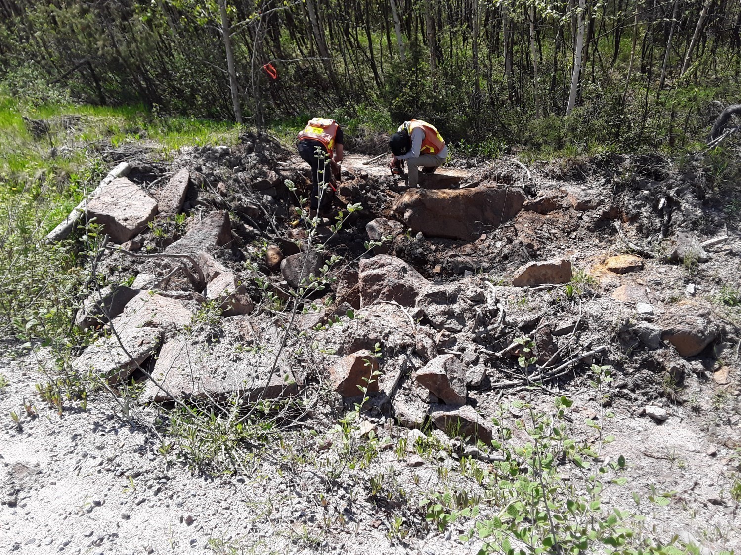
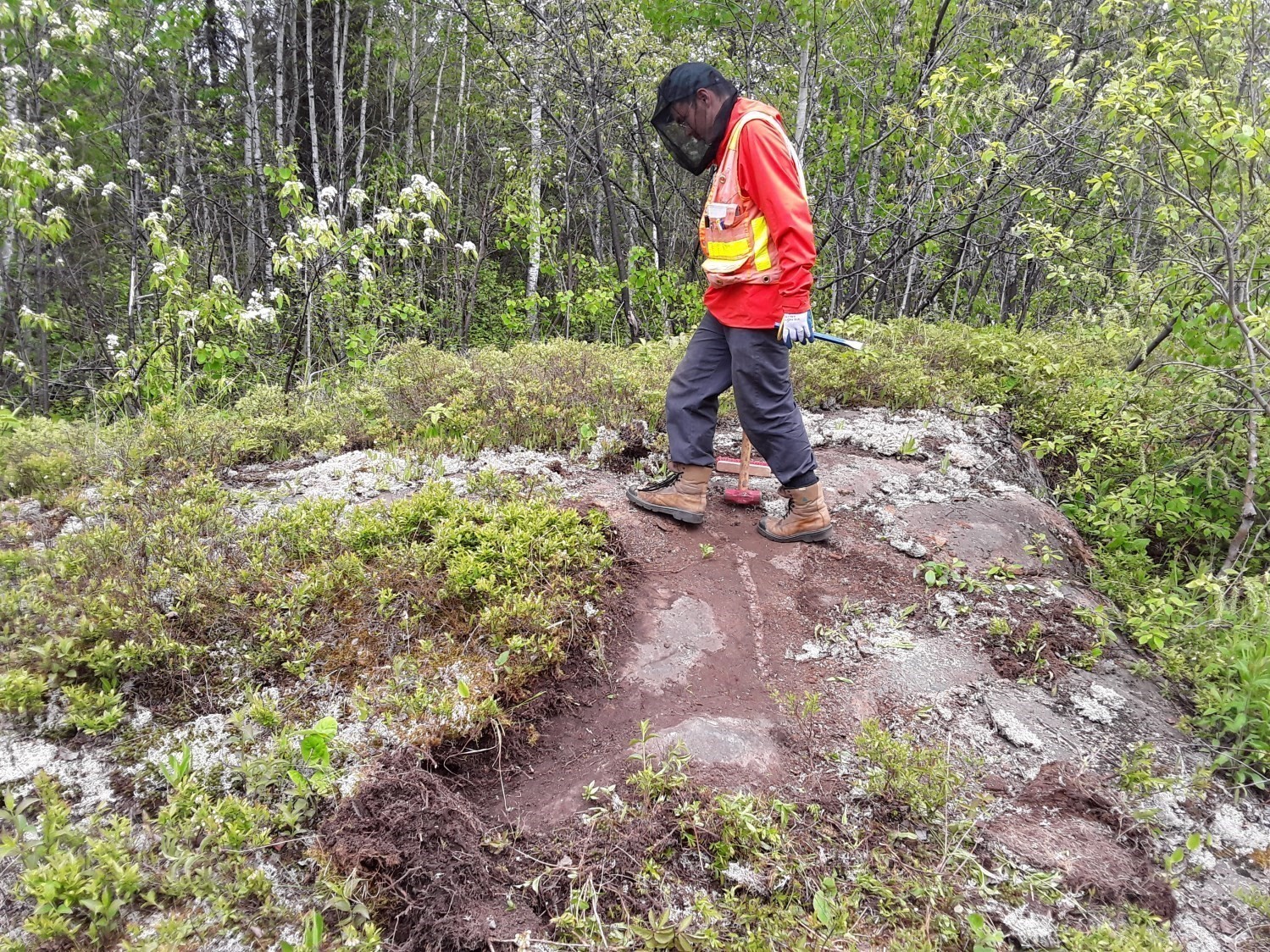
The area was mapped using the established method for surveys in forest areas served by a network of secondary roads. Geological mapping was conducted by a team of three geologists, three geologists-in-training and seven students between June 1st and August 16, 2019. The mapping and synthesis of the Normandin project has produced and updated information presented in the table to the right:
| Element | Number |
|---|---|
| Described outcrop (“geofiche”) | 1818 outcrops |
| Total lithogeochemical analysis | 125 samples |
| Lithogeochemical analysis of metals of economic interest | 46 samples |
| Geochronological analysis | 7 samples |
| Covered thin section | 121 |
| Polished thin section | 51 |
| Sodium cobaltinitrite stain | 0 |
| Stratigraphic unit | 17 |
| Structural unit | 7 |
| Mineralization record | 7 |
| Architectural, crushed or industrial stone record | 22 |
Previous Work
The table below lists the work that has been done in the study area since 1918. It also includes references cited in the report. An exhaustive list can be found in the EXAMINE documentary database.
| Author(s) | Type of Work | Contribution |
|---|---|---|
| Dresser, 1918 | Mapping of the Lake Saint-Jean area (southern part) | First geological mapping of the southern area of Lake Saint-Jean |
Mapping at scale 1:63 000 in the district of Roberval; Ph.D. thesis | Discovery and description of Fe-Ti mineralized zones Petrological study of Fe-Ti mineralization | |
| Laurin and Sharma, 1975 | Cartography and geological reconnaissance at scale 1:250 000 | Mapping project spread over several years (1965-1967) |
| Bellemare, 1998 | Inventory of quarries in the Lake Saint-Jean area | Highlighting the various possibilities for the use of rocks from quarries in the area |
| R-LaFlèche et al., 2010 | Exploration for oil and gas in the NW-SE part of Lake Saint-Jean | Support for the mapping of Ordovician rocks present on the west shore of Lake Saint-Jean (gravity and magnetometric surveys) |
| Cartography and geological reconnaissance at scale 1:250 000 | Identification of several lithostratigraphic units and update of known mineralized zones and areas for dimension stone | |
| Intissar and Benahmed, 2015 | High-resolution aeromagnetic surveys | Aeromagnetic surveys throughout the area |
Lithostratigraphy
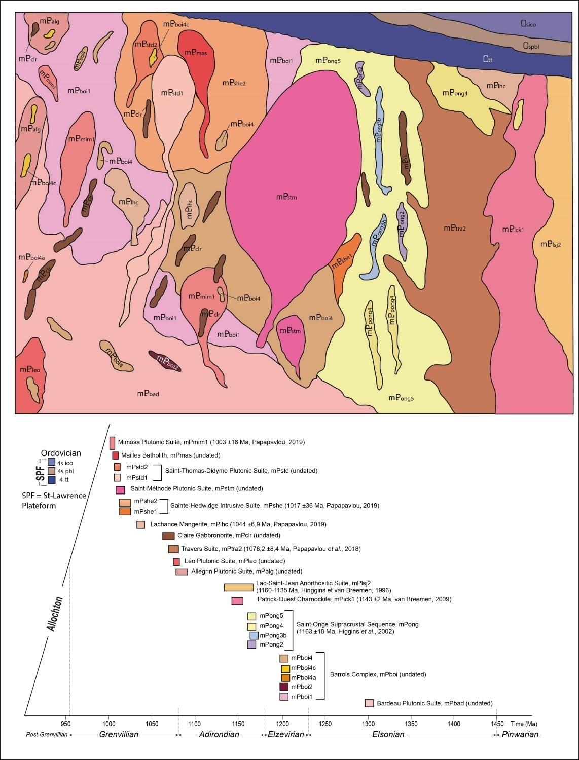
This section presents the different lithologies of the mapped area in a stratigraphic and temporal framework. The stratigraphic diagram and chronological frieze below accompany this discussion. The lithological description of units can be consulted from their respective stratigraphic records by using the hyperlink associated with their name.
Mesoproterozoic Bedrock
Bedrock
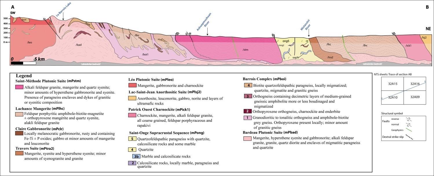
Although no dating is available to determine the age of the Bardeau Plutonic Suite (mPbad), its field relationships with other lithologies indicate that it is the oldest stratigraphic unit. This suite consists of felsic to mafic intrusive rocks that are deformed to gneissic.
The Barrois Complex (mPboi), which has not been dated, consists of metasedimentary rocks and a variable proportion of mobilisate. It overlies the Bardeau Plutonic Suite. Within the mapped area, the Barrois Complex contains four units: 1) granodioritic to tonalitic orthogneiss, amphibole and biotite grey gneiss and minor amounts of granitic gneiss (mPboi1); 2) orthopyroxene orthogneiss, charnockite and enderbite (mPboi2); 3) orthogneiss with decimetric layers of variably boudinaged and migmatized gneiss amphibolite (mPboi3); and 4) biotite quartzofeldspathic paragneiss, locally migmatitized, quartzite, migmatite and granitic gneiss (mPboi4). The latter unit is divided into three mappable subunits: a) rusty garnet-sulphide-graphite paragneiss, migmatitic paragneiss, migmatite and granitic gneiss (mPboi4a); b) paragneiss with quartzite interbeds (mPboi4b); and c) biotite ± sillimanite ± garnet ± graphite paragneiss, amphibolitized mafic volcanic rocks, marble, calcosilicate rocks, garnetite and ± graphite ± garnet quartzite (mPboi4c).
The Saint-Onge Supracrustal Sequence (mPong) is the most studied of the units since it hosts the Saint-Onge deposit, a wollastonite skarn (mPong1). This sequence of metasedimentary rocks includes four other mappable units in the Normandin area: 1) calcosilicate rocks including varying proportions of marble, paragneiss and quartzite (mPong2); 2) marble and calcosilicate rocks (mPong3b); 3) quartzite (mPong4); and 4) quartzofeldspathic paragneiss with interbeds of quartzite, calcosilicate rocks and some marble (mPong5).
Mesoproterozoic Intrusive Rocks
The intrusive and sedimentary rock packages mentioned above (mPbad, mPboi and mPong) host kilometric intrusions consisting of felsic, intermediate to mafic rocks well delineated on aeromagnetic maps (Intissar and Benahmed, 2015). These intrusions are, from the oldest to the youngest: the Lac-Saint-Jean Anorthositic Suite (mPlsj), with felsic to intermediate facies (Patrick-Ouest Charnockite, mPick1), also including mafic and ultramafic facies (mPlsj2); the Allegrin Plutonic Suite (mPalg) consisting of quartz syenite, alkali feldspar granite and gabbronorite; the Léo Plutonic Suite (mPleo), Travers Suite (mPtra) and Claire Gabbronorite (mPclr) which are lenticular kilometric masses intruding all the units mentioned above; the Lachance Mangerite (mPlhc), Sainte-Hedwidge Intrusive Suite (mPshe) and Saint-Méthode Plutonic Suite (mPstm) which consist of alkali feldspar granite, mangerite, quartz syenite and gabbronorite; the Saint-Thomas-Didyme Suite (mPstd) which includes mangerite, gabbronorite, charnockite, alkali feldspar granite and quartz diorite; the Mailles Batholith (mPmas) consisting of mangerite, charnockite, jotunite, alkali feldspar granite and gabbronorite; and the Mimosa Plutonic Suite (mPmim1) consisting of mangerite, quartz syenite, hypersthene syenite, monzogranite, alkali feldspar granite and minor amounts of jotunite and gabbronorite.
Ordovician Sedimentary Rock Cover
SW of the mapped area, sequences of sedimentary rocks (limestone, shale) of the St. Lawrence Platform unconformably (angular discordance) overlie Mesoproterozoic units. These Ordovician sedimentary rocks belong to the Trenton Group (Ott), Pointe-Bleue Formation (Ospbl) and Île aux Couleuvres Formation (Osico). The latter consists mostly of greyish limestone, locally argillaceous or cherty (Desbiens and Lespérance, 1989).
Lithogeochemistry
The lithogeochemistry of units in the Normandin area is presented separately in tabular form.
Structural Geology
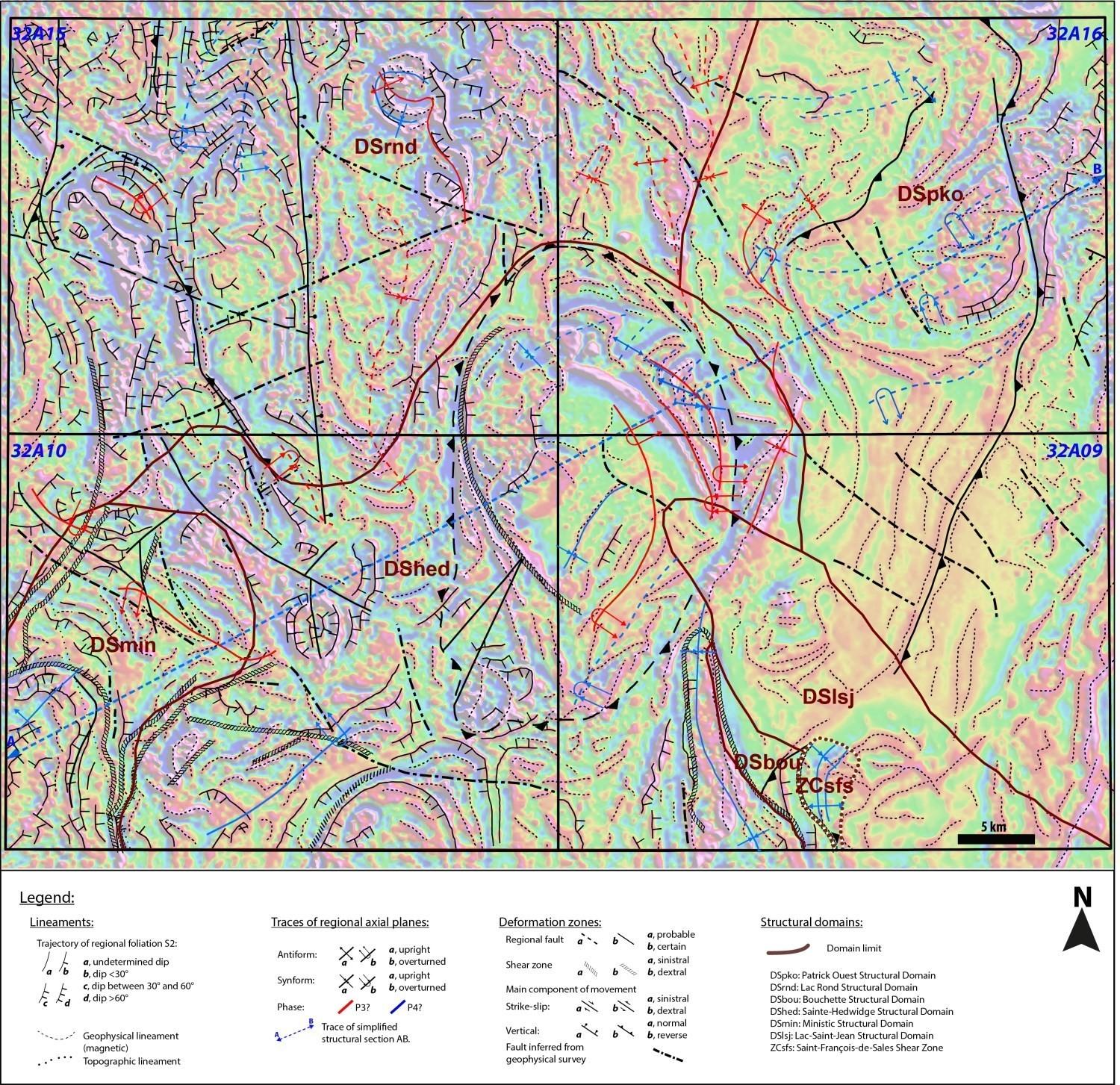
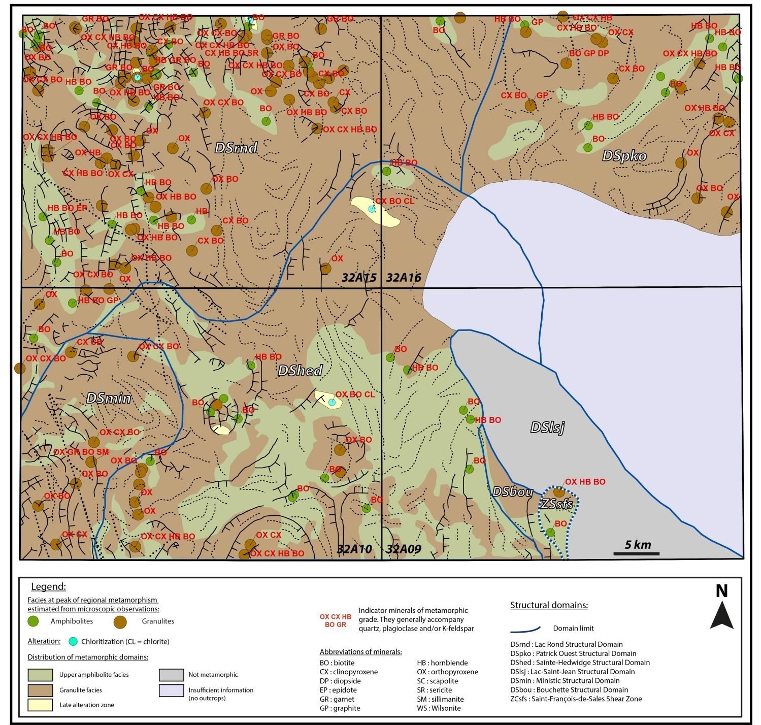
The Normandin area has been divided into seven structural domains. These are the Bouchette (DSbou), Lac-Saint-Jean (DSlsj), Ministic (DSmin), Sainte-Hedwidge (DShed), Patrick Ouest (DSpko) and Lac Rond (DSrnd) structural domains as well as the Saint-François-de-Sales Shear Zone (ZCsfs). These domains are individualized and delineated on the basis of the attitude of planar and linear structures as well as lineaments inferred from geophysical surveys. The boundaries between domains generally correspond to a change in the direction of the main foliation (Sn) coupled with the orientation of regional axial planes. Analysis of structural data in the Normandin area indicates that these domains underwent at least three deformation phases; the attitude and intensity of each phase vary from one domain to another.
The Patrick Ouest Structural Domain (DSpko) occupies the eastern and NE part of the Normandin area and mainly includes fabrics of the Lac-Saint-Jean Anorthositic Suite, Patrick Ouest Charnockite, la Lachance Mangerite, Travers Suite and Saint-Onge Supracrustal Sequence. The various structural measurements of this domain come from its NE and northern parts (sheet 32A16), whereas there are very few outcrops in the rest of the domain. However, it is affected by the deformation D2 marked by fairly homogenous trajectories of the planar fabric, oriented NNE-SSW on average and dipping towards the ENE (mean foliation S2 of 024°/47°). Deformation is generally expressed by gneissosity in calcosilicate rocks and paragneiss of the Saint-Onge supracrustal Sequence or by a secondary tectonometamorphic mineral foliation in intrusive rocks of other lithostratigraphic units. The lineations borne by these planar structures are of the oblique dipping type with a plunge towards the ESE.
Two phases of folding (P3, P4) (deformations D3 and D4) characterize this domain; they are either defined by the interpretation of field measurements, or inferred from high-resolution maps of the magnetic field, or both (Intissar and Benahmed, 2015). Axial planes are on average oriented N-S for P3 and NE-SW for P4, and are generally represented by isoclinal folds, upright or overturned either eastward or westward.
The Lac Rond Structural Domain (DSrnd), located N and NW of the mapped area, presents planar and linear fabrics of the Bardeau Plutonic Suite, Barrois Complex, Mimosa Plutonic Suite, Saint-Thomas-Didyme Suite, Mailles Batholith, Allegrin Plutonic Suite and Sainte-Hedwidge Intrusive suite. The oldest lithological units of this domain (Bardeau Plutonic Suite and Barrois Complex) are recrystallized, deformed and folded by multiple pre-Grenvillian deformation events (>1080 Ma). The primary structures of these units were transposed during a first phase of deformation Dn-1 whose fabric and orientation were obliterated by subsequent deformation events (Dn, Dn+1 and Dn+2), i.e. during the Grenvillian Orogenesis. In this domain, the planar fabric Dn (S2, G2) has a dominant N-S direction and a moderate dip eastward. It is marked by migmatitic banding or gneissosity in metasedimentary rocks or by diffuse tectonometamorphic mineral foliation in intrusive rocks with the preferential orientation of ferromagnesian minerals and, locally, by the alignment of long axes of K-feldspar phenocrystals in porphyraceous rocks. This fabric bears mineral and stretch lineations having an oblique component or dip, reflecting the final configuration of the domain’s units into domes and basins identified at different scales by westward or eastward dip inversions.
The Ministic (DSmin), Sainte-Hedwidge (DShed), Bouchette (DSbou), Lac-Saint-Jean (DSlsj) structural domains and the Saint-François-de-Sales Shear Zone (ZCsfs) were defined by Moukhsil and Daoudene (2019) in the Commissaires Lake area (BG-2019-01). Their continuity towards the north occupies the southern part of the Normandin area. Generally speaking, the planar fabric D2 has a mean direction NE-SW (DSmin) or N-S to NW-SE (DShed and DSbou).
Rocks emplaced during the Grenvillian Orogenesis are variably deformed. The structural section illustrates the final shape of the lithologies of the area and their relationships with normal and reverse faults as well as shear zones (sinistral or dextral strike-slip).
Ordovician rocks (limestone, shale) of the St. Lawrence Platform, exposed on the west shore of Lake Saint-Jean, are undeformed (Lac-Saint-Jean Structural Domain [DSlsj]) and unconformably overlie Mesoproterozoic rocks, as shown on the stratigraphic diagram of the area.
Metamorphism
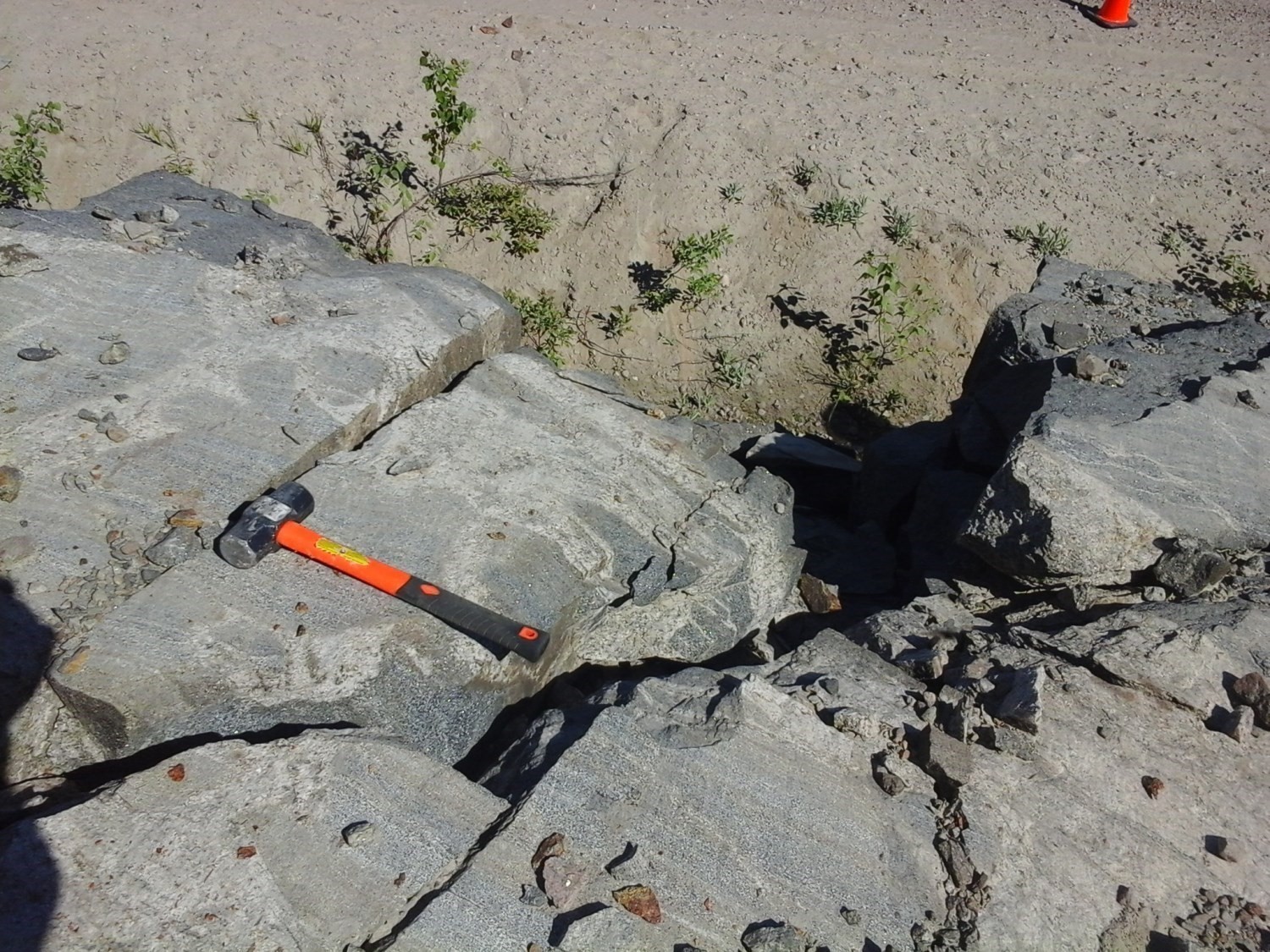
Rocks of the area display many evidence of amphibolite and granulite facies’ prograde metamorphism. The study of the regional metamorphic evolution was mainly based on mineralogical and textural observations, both macroscopic and microscopic (163 samples representative of Mesoproterozoic units). In addition, it is based on a wide range of samples covering the entire mapped territory and containing diagnostic minerals of high-temperature metamorphism, whose conditions vary within a structural domain (metamorphic map). Aluminous paragneiss (metapelite) is a type of lithology more suitable for this study. Indeed, in the NW part of sheet 32A15 (outcrop 19-AM-02), a paragneiss of the Barrois Complex (mPboi4c) contains a biotite-sillimanite-garnet paragenesis that indicates upper amphibolite facies metamorphism.
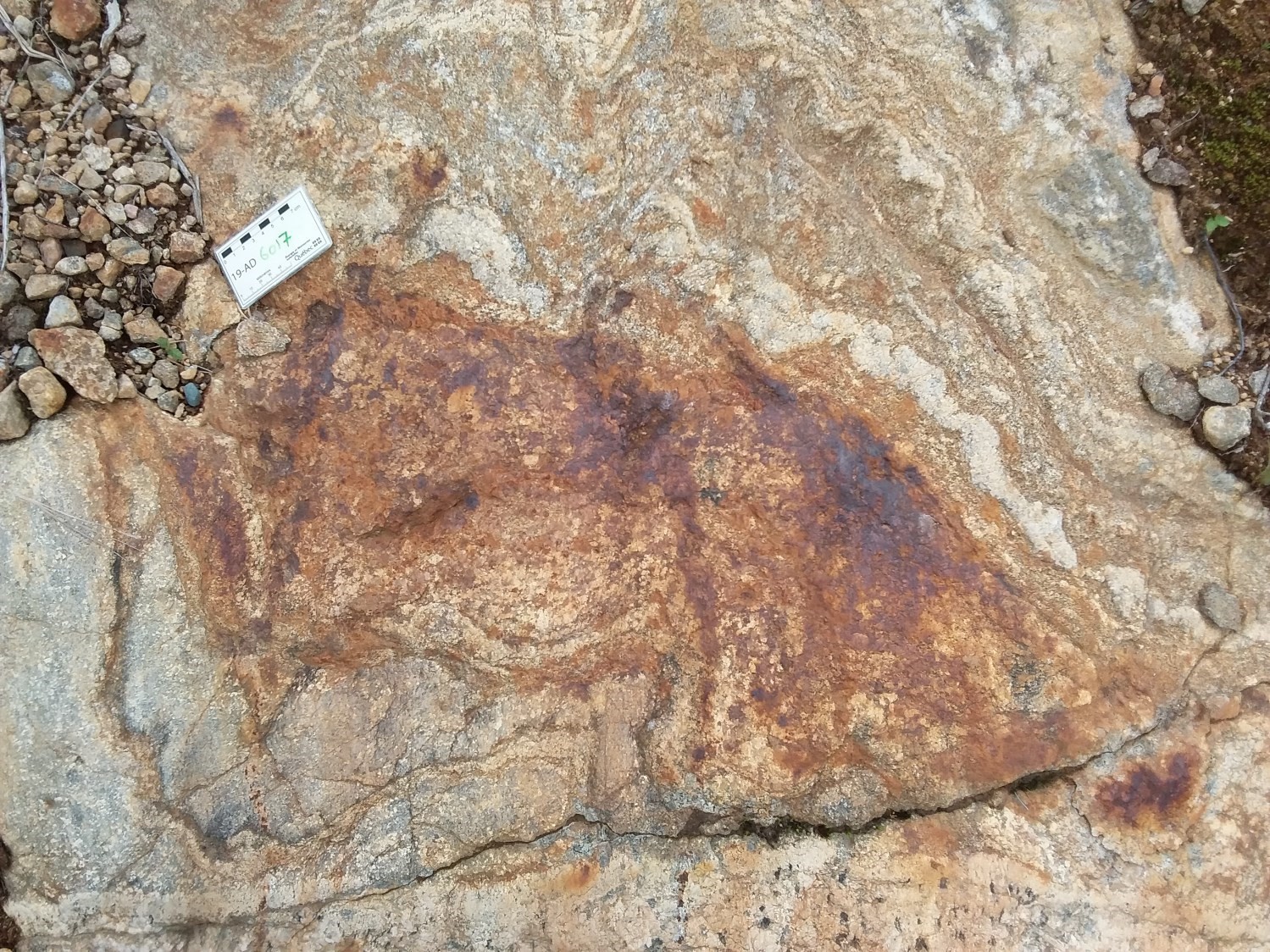
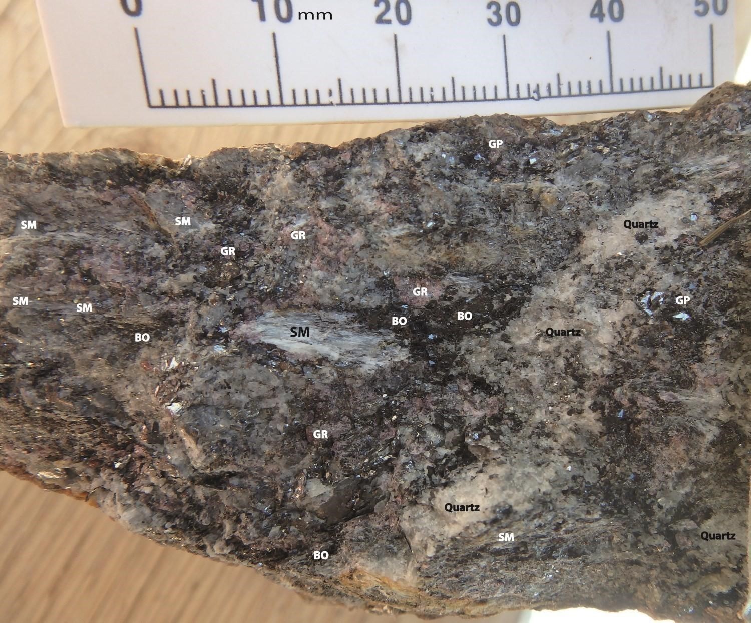 Other parts of the area display the same paragenesis associated with the Barrois Complex (outcrop 19-AD-6017). The latter may be migmatitic and have undergone partial melting, as millimetric to centimetric, generally granitic stromatic mobilisate is observed. Paragneiss layers of pelitic protolith are enriched in sillimanite, biotite and garnet. They are associated with the presence of quartz (QZ) and a minor amount of K-feldspar (FK), while muscovite (MV) is absent. This suggests a transition from the muscovite-quartz-sillimanite-alkali-feldspar-biotite assemblage (also called the « muscovite-out » reaction) to the sillimanite-staurolite-garnet-plagioclase-biotite-quartz assemblage, also associated with graphite, thus allowing the granulite facies to be reached under a medium P/T metamorphic gradient (Winter, 2001). In a biotite-rich paragneiss sample (19-AD-6017-D1), the following mineralogical assemblage is observed: biotite-sillimanite-staurolite-garnet-plagioclase-quartz (muscovite absent), which indicates high-temperature and medium-pressure metamorphism.
Orthopyroxene is pervasive in rocks of the area. It has been observed in the field and in thin sections of several felsic, intermediate and mafic plutonic suites. This indicates that these rocks were emplaced over a long period of time under temperature and pressure conditions equivalent to those of the granulite facies. Observation of K-feldspar having perthitic and mesoperthitic textures in felsic and intermediate intrusive rocks also indicates high temperature conditions.
Throughout the area, in some intrusive rocks there is partial to complete replacement of pyroxenes by amphibole, locally with pyroxene cores remaining, indicating retrograde metamorphism at amphibolite facies temperature conditions. In some areas, the development of late alteration characterized by the presence of chlorite and epidote associated with biotite and pyroxene was also noted.
Economic Geology
The Normandin area presents prospective zones for four types of mineralization:
- Zn mineralization associated with metasedimentary rocks of undetermined type;
- Rare earth ± Th ± Nb ± Ta mineralization associated with granitic dykes, syenitic intrusions and alkali feldspar granites;
- Magmatic Fe-Ti (± P ± V) mineralization associated with mafic and ultramafic intrusive rocks;
- Magmatic Cu-Ni mineralization (± Co ± EGP) associated with mafic to ultramafic intrusions.
The table of mineralized zones below presents analytical results for the ten known mineralized zones in the area, including one discovery from our mapping work and six (6) known mineralized zones.
Mineralized Zones of the Normandin Area
| Name | Contents | Comments |
|---|---|---|
| Rare Metal Mineralization Associated with Hyperalkaline Rocks | ||
| Jacques1 | 7486 ppm REE (G); 1300 ppm Th (G) | |
| Name | Contents | Comments | ||
|---|---|---|---|---|
| Rare Metal Mineralization Associated with Hyperalkaline Rocks | ||||
| Lac Jacques | 16 952.91 ppm ETR (G); 4680 ppm Cu (G); 421 000 ppm Fe (G); 10 ppm Zr (G); 8480 ppm Ce (G); 4580 ppm La (G); 2050 ppm Th (G); 2790 ppm Nd (G) | Outcrops 19-FS-7009 and 19-FS-7010 | ||
| Magmatic Ni-Cu (± Co ± EGP) Mineralization | ||||
| Lac Croche | 2506 ppm Cu (G); 1548 ppm Ni (G); 1.3 ppm Ag (G) | |||
| Undetermined Type of Mineralization | ||||
| Lac du Milieu | 12 011.18 ppm REE over 0.1 m (R); 992 ppm Th over 0.1 m (R); 5830 ppm Ce over 0.1 m (R); 3330 ppm La over 0.1 m (R); 1935 ppm Nd over 0.1 m (R) | |||
| Lac du Raton | 8332.08 ppm REE over 0.1 m (R); 1000 ppm Th over 0.1 m (R); 10 000 ppm Zr over 0.1 m (R); 4200 ppm Ce over 0.1 m (R); 2120 ppm La over 0.1 m (R); 1345 ppm Nd over 0.1 m (R) | |||
| Paul Lapointe | 17 780 ppb Au (G); 10.17 ppm Ag (G) | |||
| Saint-Eugène | 14 200 ppm Cu over 0.8 m (D); 1390 ppb Au over 0.8 m (D) | |||
| Architectural, Crushed and Industrial Stone | ||||
(D): Diamond drilling; (G): Selected sample; (R): Groove – chip sample
Known Mineralized Zones in the Study Area
Rare Metal Mineralization Associated with Granitic Pegmatites and Alkali Feldspar Granites
Rare earth element (REE) mineralization was already known in the area (Lac Jacques mineralized zone). It is concentrated in granitic clusters and granitic to syenitic pegmatite dykes containing carbonates (calcite). Clusters are centimetric, medium to coarse grained and contained within paragneiss of the Barrois Complex. Dykes also intrude paragneiss and gabbronorite (Claire Gabbronorite). Two samples (19-FS-7009C1 and 19-FS-7010B1) were collected in the vicinity of the Lac Jacques mineralized zone during our work.
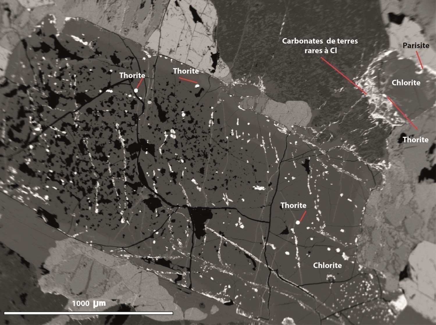
The surface of outcrop 19-FS-7009 consists of 70% migmatized gabbronorite and 30% pegmatite dykes (3 m thick by 20 m long). Gabbronorite contains millimetric tonalitic mobilisate. Rare earth element mineralization is associated with the granitic pegmatite dyke, which is peraluminous and of alkaline affinity. REEs are contained in rare earth calcium fluorocarbonates (parisite), filling microfractures or occurring along the edges of magnetite and chlorite grains. The presence of yttrialite and thorite in the rock explains the Y and Th contents, respectively. Hematite and minerals containing traces of uranium and silver are also present in the dyke. A selected sample (19-FS-7009-C1) taken from the dyke yielded contents of 3317 ppm total REE, 401 ppm Th, 464 ppm Y, 568 ppm Nb and 10.9 ppm Ta.
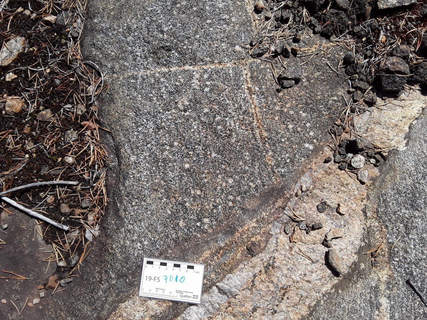
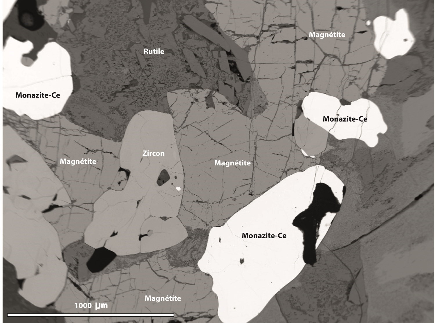
Outcrop 19-FS-7010 consists of gabbronorite cut by an alkali feldspar granite dyke ~1 m thick and oriented 268°. Within this dyke, calcite and rare earth element mineralization are mainly contained in Ce-monazite and carbonates. Spinel, rutile, biotite, magnetite, zircon, quartz and feldspar are also observed in the dyke. A selected sample (19-FS-7010-B1) in the dyke yielded 8270 ppm total REE (including 1320 ppm Nd) and 1340 ppm Th.
Magmatic Ni-Cu (± Co ± EGP) Mineralization
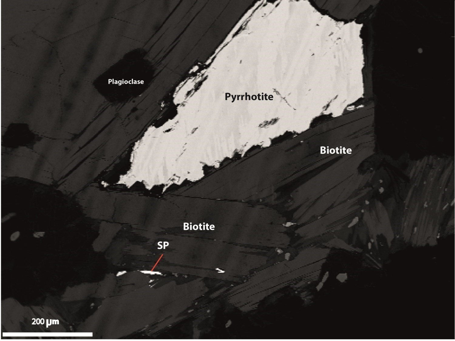
Mineralization consists of pyrrhotite and chalcopyrite disseminated in leucocratic gabbronorite (Lac Croche mineralized zone). Traces of pentlandite or bravoite form exsolution flames, grains or chains in pyrrhotite (Huss, 2000). Mineralization is magmatic, but there is local remobilization of sulphides in certain millimetric fractures.
Architectural, Crushed and Industrial Stone
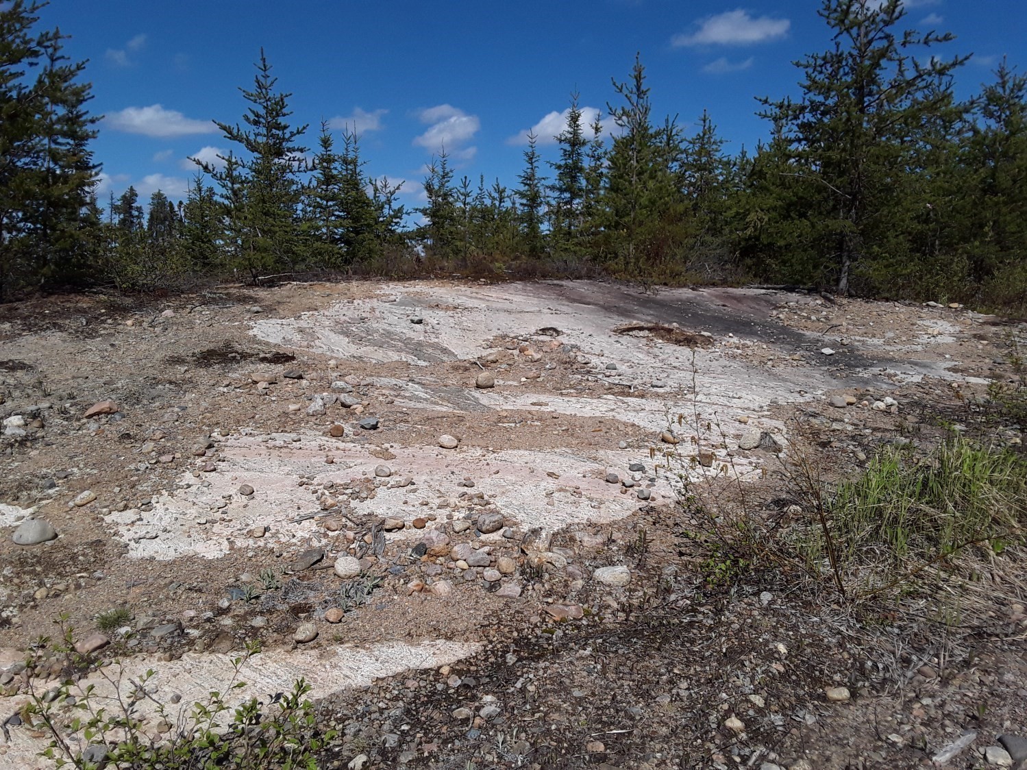
There are 22 known stone and aggregate quarries in the mapped area. Extracted resources are used for the production of architectural stone, crushed stone, rock fill, as well as industrial limestone, agricultural lime and aggregates (roads, decorative stone, etc.). These quarries are active year-round or intermittently.
Little-Known Mineralization and Discoveries Made During the Present Work
Prospective Zones for Zn Mineralization Associated to Sillimanite-Garnet Metasedimentary Rocks
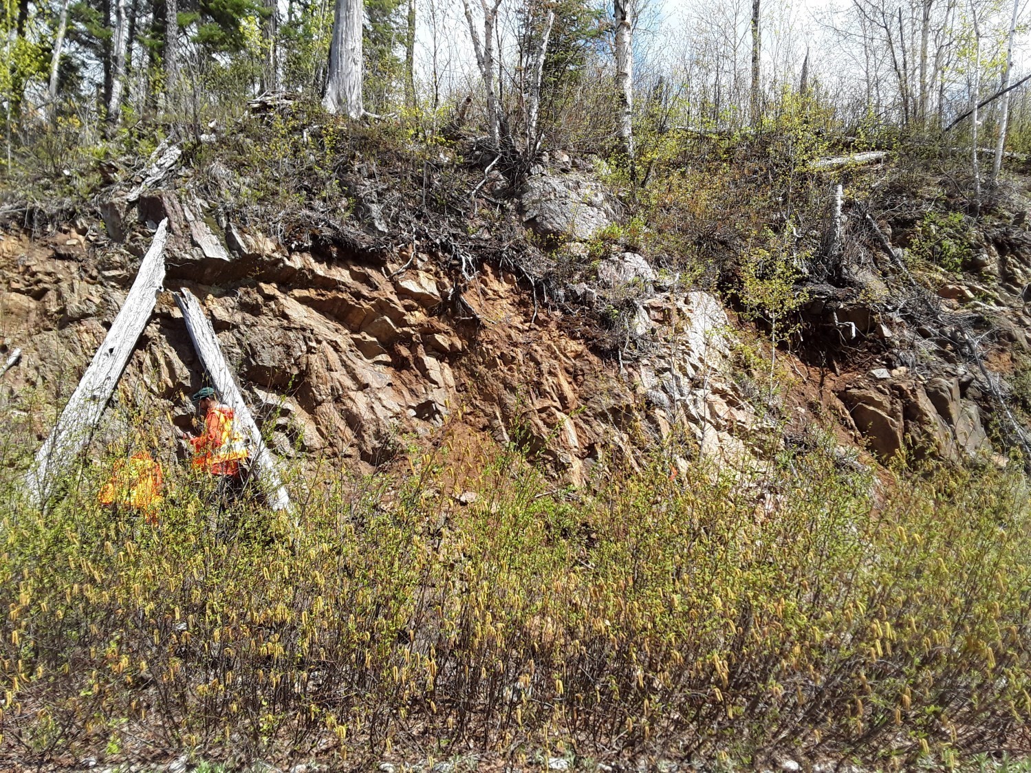
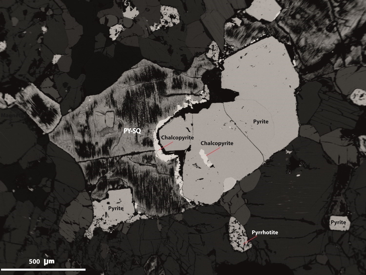
The Moncou prospective zone consists of paragneiss (>80%) and quartzite of the Barrois Complex (mPboi4c); these lithologies are cut by a multitude of centimetric to decimetric gabbronorite, granite and pegmatite dykes. Paragneiss is rusted and altered. It is composed of millimetric biotite flakes (~40%), sillimanite, graphite, garnet and <1% sulphides (pyrite, chalcopyrite and pyrrhotite) associated with iron oxides (magnetite, ilmenite and goethite).
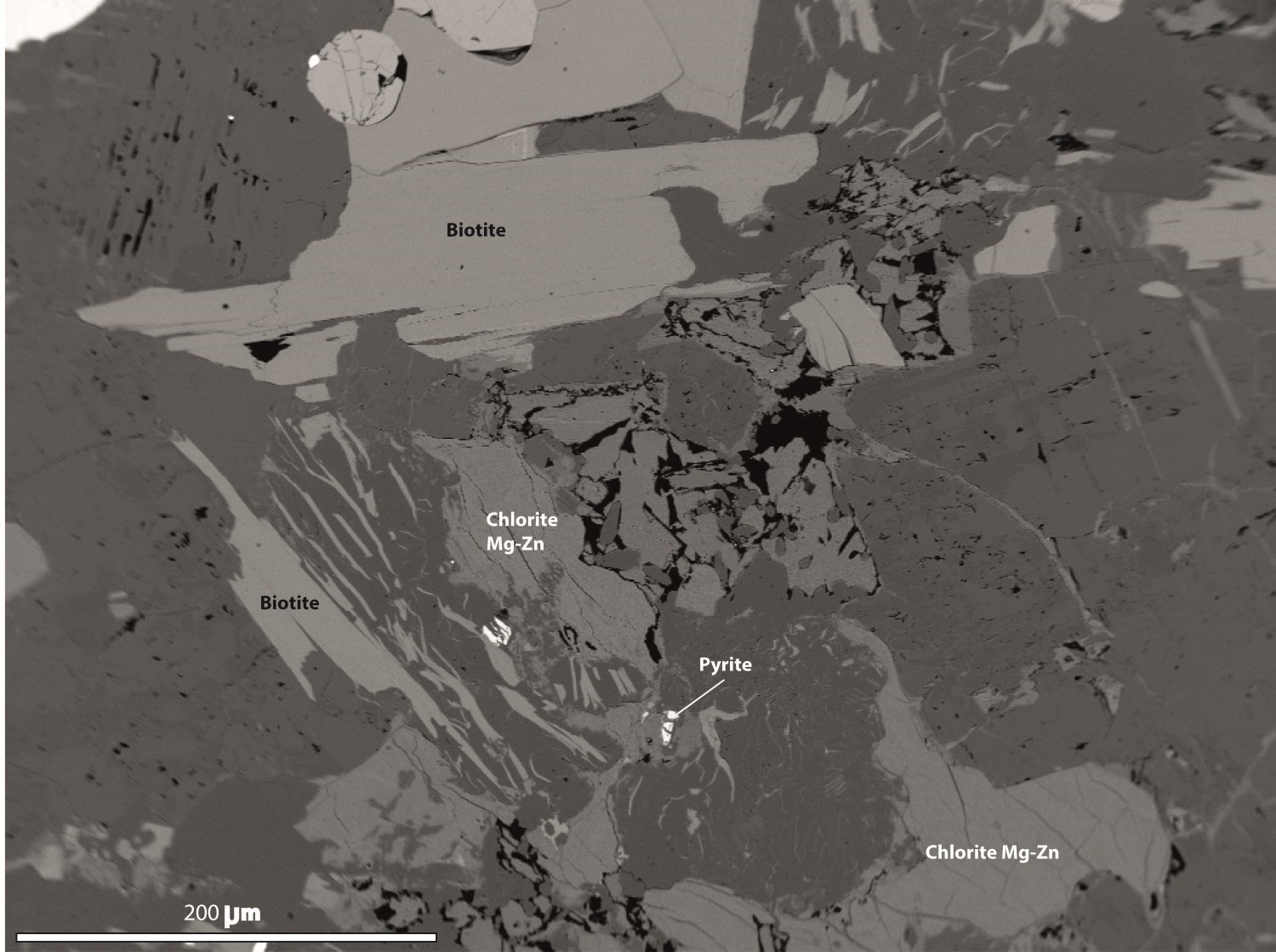
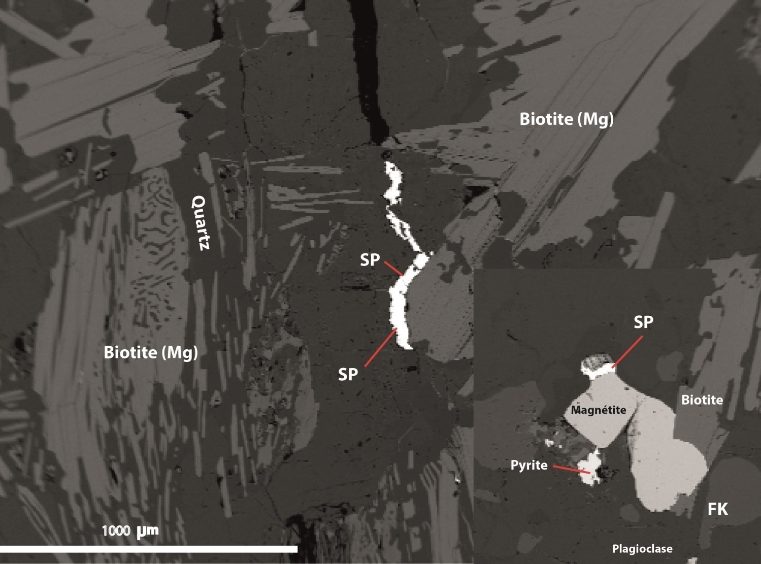
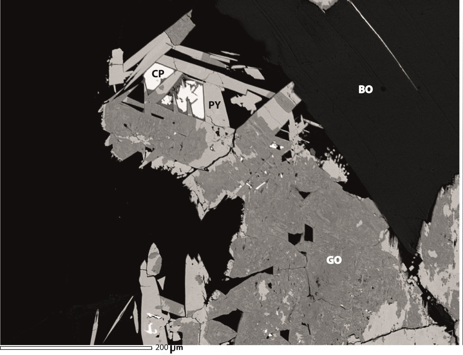
Zinc mineralization is represented by a silicate phase composed of Mg-Fe-Zn-chlorite, an iron-enriched Cu-Zn mineral surrounding pyrite and, probably, trace amounts of gahnite. Millimetric sphalerite rarely occurs in contact with pyrite and magnetite. It was observed more specifically in sample 19-AM-02-A3. The mineralized paragneiss also contains Mg-biotite (phlogopite), fluorapatite, monazite and large carbonate clusters. A 1.5 m to 2 m thick quartzite bed contains ~2% graphite and 1% disseminated sulphides (pyrite and pyrrhotite). Three samples (A1, A2 and A3) from outcrop 19-AM-02 yielded contents of 2940 ppm Zn, 620 ppm Zn and 955 ppm Zn respectively. A quartzite sample (19-AM-02-B1) yielded a content of 200 ppm Zn.

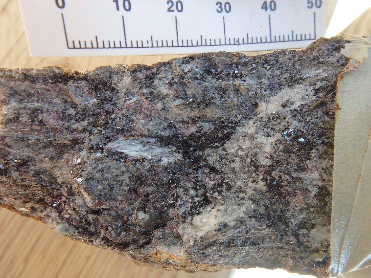
The Gros Mâle prospective zone contains two outcrops (19-AD-6017 and 19-AD-6020). This zone is located ~10 km SE of the Moncou prospective zone and consists of migmatitic paragneiss with layers of calcosilicate and metasomatic rocks of the Barrois Complex (mPboi4c). The latter also includes garnetite and quartzite. Garnetite contains 45% garnet, ~6% quartz, 20% biotite, 10% chlorite, 5-10% sillimanite, 5% graphite disseminated in millimetric flakes (1-5 mm), <1% ilmenite, 1% staurolite containing quartz inclusions, 1% pyrite, pyrrhotite, pentlandite and chalcopyrite including traces of micrometric sphalerite, and 1% zircon. Two analyzed samples (19-AD-6017-D1 and 19-AD-6020-F1) from this zone yielded contents of 951 ppm Zn and 174 ppm Zn respectively, with a content of 100 ppm Pb for sample AD-6017-D1. Zinc is concentrated in a few sphalerite crystals, but is also present in more or less magnesian chlorite. Staurolite may also contain some (not analyzed under an electron microscope).
Three New Prospective Zones for Magmatic Mineralization in Rare Earth Elements (± Th ± Nb ± Ta) Associated with Granitic Pegmatite Dykes, Syenites and Alkali Feldspar Granites

The first prospective zone, Jacques1, corresponds to outcrop 19-FS-7016 located 14.7 km NW of Saint-Thomas-Didyme. It is characterized by several dykes and clusters of granitic pegmatite, of peraluminous affinity (14.63% Al2O3) and enriched in potassium (5.56% K2O). The main dyke has a thickness varying from 10 cm to 50 cm and is oriented 037°/89°. The mineralization consists of 3-5% Ce-monazite associated with biotite and magnetite. Mn-ilmenite, rutile, zircon and barite are also observed in pegmatite. Selected sample 19-FS7016-C1 yielded contents of 7486 ppm total REE (including 1160 ppm Nd) and 1300 ppm Th.
The second prospective zone, Du Milieu1, contains the known Lac du Milieu mineralized zone discovered in 2007, as well as several outcrops mapped in the Normandin area (19-AM-05, 19-AB-5001). Lithologies hosting the mineralization are quartz syenite and alkali feldspar granite of the Sainte-Hedwidge Intrusive Suite (mPshe2). Syenite is magnetic, medium to coarse grained and composed of orthopyroxene, biotite, allanite and monazite. Alkali feldspar granite also contains allanite. Mineralization in this zone consists of rare earth elements concentrated in monazite and allanite. Significant niobium (Nb) contents are also associated with this mineralization. A selected sample (19-AM-05-A1) of syenite yielded 1228 ppm total REE and 33.4 ppm Nb. Two samples (19-AB-5001-B1 and 19-AB-5001-B2) of alkali feldspar granite yielded respective contents of 1073 ppm total REE and 1184 ppm total REE, and 58 ppm Nb and 53.4 ppm Nb.
The third prospective zone, Des Marchand, consists of rare earth element and niobium mineralization contained in an alkaline feldspar granite (Mimosa Plutonic Suite). The rock is enriched in biotite, medium to coarse grained and includes millimetric allanite and monazite crystals (<2%). Selected sample 19-AD-6153-A1 yielded contents of 1412.59 ppm total REE and 27.4 ppm Nb.
New Prospective Zones for Magmatic Fe-Ti (± P ± V) Mineralization Associated with Mafic and Ultramafic Intrusive Rocks
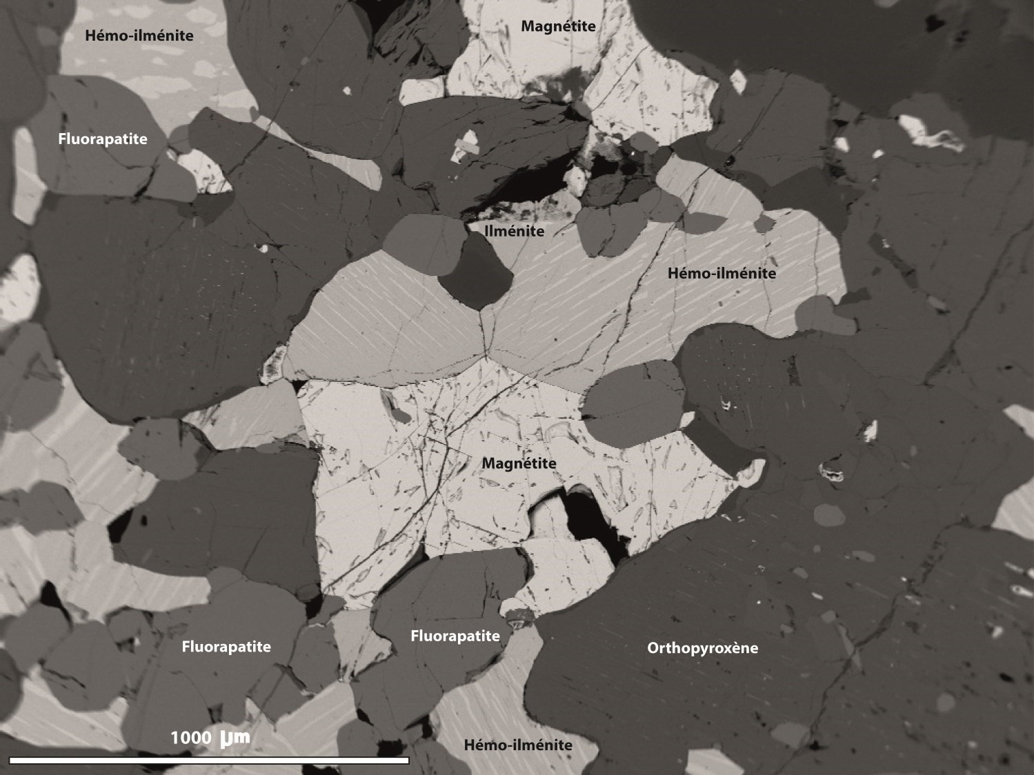
The Mailles prospective zone is located through outcrop 19-AM-22, in addition to outcrops 19-AM-20 and 19-AM-21. In the field, our work focused on this zone, as it hosts a known Ni-Cu (± Co ± PGE) mineralized zone (Lac Croche). Visible sulphides are disseminated and account for <1% of the rock; they consist of pyrite, pyrrhotite and chalcopyrite. However, the mineral potential of this zone is more for OAGN-type Fe-Ti-P ± V oxides (oxide-apatite gabbronorite, OAGN; Owens and Dymick, 1992). Indeed, the zone consists of porphyritic gabbronorite belonging to the Mailles Batholith. The rock contains the following minerals: magnetite, slightly vanadiferous titanomagnetite, ilmenite, hemo-ilmenite as exsolution in magnetite and fluorapatite. A sample taken on outcrop 19-AM-22-A1 yielded contents of 17.4% Fe, 3.76% P2O5, 7.016% TiO2, 192 ppm Zn and 579 ppm V.

The Simard prospective zone, located through outcrop 19-ME-4044, consists of very rusty and highly magnetic subophitic gabbronorite forming part of the Mailles Batholith. The size of plagioclase and biotite crystals is medium to coarse, while that of pyroxenes (clinopyroxene and orthopyroxene) and Fe-Ti oxides is generally fine. Oxides (magnetite, ilmenite and hemo-ilmenite) accounts for 5% to 15% of the rock and are associated with a few small apatite crystals (fluorapatite). The analysis of a selected sample (19-ME-4044-A1) yielded contents of 12.6% Fe, 3.57% P2O5, 274 ppm Zn, 4.15% TiO2 and 243 ppm V.
The Du Cran prospective zone is located 1.25 km NE of the lake of the same name. It includes outcrop 19-AM-06 hat consists of medium to coarse-grained, strongly magnetic, rusty gabbronorite of the Mimosa Plutonic Suite. The rock contains 15% Fe-Ti-P ± V oxides (OAGN type), pyroxenes (clinopyroxene and orthopyroxene) and traces of disseminated sulphides (<1% pyrite and pyrrhotite). Oxides are disseminated and forming millimetric hemo-ilmenite crystals (~15%), ilmenite (1%) and vanadium-bearing magnetite (20%); these are associated with apatite (7%). The typical outcrop is ~100 to 200 m2 and is in contact with mangerite of the same plutonic suite. Selected sample 19-AM-06-A1 yielded contents of 16% Fe, 3.75% TiO2, 4.02% P2O5 and 536 ppm V.
New Prospective Zone for Magmatic Ni-Cu (± Co ± PGE) Mineralization Associated with Mafic to Ultramafic Intrusions

The Lebreux prospective zone corresponds to a gabbronorite (60%) outcrop associated with mineralized clinopyroxenite (40%), cut by a stockwork of irregular veins and veinlets 1 cmo 4 cm thick. The veinlets’ filling is mainly composed of clinopyroxene and 3-5% (up to 10% locally) millimetric anhedral sulphides (pyrrhotite, pyrite, traces of chalcopyrite). High silicification is noted mainly in contact with the pyroxenitic host. Copper mineralization is borne by chalcopyrite, which occurs as inclusions in pyrite or as a rim around it. Nickel contents are associated with pentlandite in micrometric inclusions within pyrrhotite, all as inclusion in the generally skeletal pyrite. Analysis of a selected sample (19-CD-10094-B1) of clinopyroxenite yielded contents of 261 ppm Ni, 207 ppm Zn and 40 ppm Nb, while sample 19-CD-10094-C1 taken from the stockwork yielded contents of 448 ppm Cu, 171 ppm Ni, 162 ppm Zn.
Issues for Future Work
The new 1:50 000 scale geological map significantly improves stratigraphic, structural and metallogenic descriptions of the Normandin area, NW of Lake Saint-Jean. However, a few issues remain to be resolved, including:
1) better defining the type of Zn mineralization and its continuity towards the east and north;
2) better defining the type of Nb mineralization and evaluating its association with alkaline to hyperalkaline rocks of the area.
For the moment, our electron microprobe analysis work indicates that Zn mineralization is associated with metasedimentary rocks, and that it is mainly hosted in magnesian chlorites and in a few micrometric sphalerite grains. The low contents of the latter and, for example, of minerals resulting from its desulphurization (gahnite), do not allow classifying this mineralization in the Sedex type (sedimentary zinc mineralization of exhalative type).
Significant Nb contents obtained in several alkali feldspar granite dykes and syenite intrusions of the area remain to be defined. On the other hand, two Nb mineralized zones are known to occur NNE of Normandin, namely Crevier, located 73 km away (sheet 32H07), and Carbonatite de Girardville located 23 km away (sheet 32H02). The Crevier mineralized zone has been worked further and reveals mineralization hosted in a swarm of pegmatitic nepheline syenite dykes associated with a nepheline syenite intrusion containing some carbonatite phases (Groulier et al., 2020). However, the discovery of these lithologies immediately north of the study area could help understanding the nature of this Nb mineralization.
| Authors | Abdelali Moukhsil, P. Geo., Ph.D. abdelali.moukhsil@mern.gouv.qc.ca Mhamed El Bourki, GIT, M.Sc. mhamed.elbourki@mern.gouv.qc.ca |
| Geochemistry | Fabien Solgadi, P. Geo., Ph.D. |
| Geophysics | Rachid Intissar, P. Geo., M.Sc. |
| Potential assessment | Virginie Daubois, P. Geo., M.Sc. |
| Logistics | Marie-Dussault, coordinator |
| Geomatics | Sylvie Tétreault, geomatics technician Kathleen O’Brien, geomatics technician |
| Template and content compliance | François Leclerc, P. Geo., Ph.D. |
| Coaching/mentoring and critical review | Fabien Solgadi, P. Geo., Ph.D. |
| English version | Céline Dupuis, P.Geo., Ph.D. |
| Organization | General direction of Géologie Québec, Ministère de l’Énergie et des Ressources naturelles, Government of Québec |
Acknowledgements:
This Geological Bulletin was made possible through the cooperation of many people who have been actively involved in the various stages of the project. We would like to thank geologist-in-training Abdelhalim Benhacine and Ahmed Dhab, as well as Claude Dion, engineer, Fabien Solgadi, geologist, students Joël Chalifoux-Trudeau, Marie Desrosiers, Audrey-Anne Lalonde, Johnatan Sylvain-Bravo, technician Raphaël Sirard, including students of the Field School Gaëtan Giroux and Dorian Joncour for their excellent work. Discussions with Kostas Papapavlou (geochronologist) were very beneficial. Helicopter transport in the field was provided by Héli-Inter.
References
Publications of the Government of Québec
BELLEMARE, Y. 1998. INVENTAIRE DES CARRIERES DE PIERRE DANS LA REGION DU LAC SAINT-JEAN (PARTIE-OUEST) (SNRC 32 A). MRN. MB 98-03, 96 pages and 1 plan.
BRAY, J G. 1959. PRELIMINARY REPORT ON LYONNE AREA, ROBERVAL ELECTORAL DISTRICT. MRN. RP 387(A), 9 pages and 1 plan.
BRAY, J G. 1960. LA LIEVRE AREA (COMTE DE ROBERVAL). MRN. DP 463, 78 pages and 1 plan.
HEBERT, C., VAN BREEMEN, O., CADIEUX, A M. 2009. REGION DU RESERVOIR PIPMUACAN, (SNRC 22 E): SYNTHESE GEOLOGIQUE. MRNF, COMMISSION GEOLOGIQUE DU CANADA. RG 2009-01, 59 pages and 1 plan.
HUSS, L. 2000. Rapport de visite du projet Sibelius III. CLAIMS SENECHAL, CLAIMS PILOTE. Assessment report submitted to the Government of Québec. GM 59667, 33 pages and 3 plans.
INTISSAR, R., BENAHMED, S. 2015. LEVE MAGNETIQUE AEROPORTE DANS LE SECTEUR OUEST DU LAC-ST-JEAN, PROVINCE DE GRENVILLE. MERN, GOLDAK AIRBORNE SURVEYS. DP 2015-06, 7 pages and 2 plans.
LAURIN, A F., SHARMA, K N M. 1975. REGION DES RIVIERES MISTASSINI, PERIBONCA, SAGUENAY, (GRENVILLE 1965-1967). MRN. RG 161, 103 pages and 10 plans.
MOUKHSIL, A., DAOUDENE, Y. 2019. Géologie de la région du lac des Commissaires, Province de Grenville, région du Saguenay-Lac-Saint-Jean, Québec, Canada. MERN. BG 2019-01, 1 plan.
MORFIN, S., TREMBLAY, C., SOLGADI, F., MOUKHSIL, A., DAIGNEAULT, R. 2015. GEOLOGIE DE LA REGION DE CHAMBORD, ROBERVAL ET NOTRE-DAME-DE-LA-DORE (FEUILLETS SNRC 32A08, A09 ET A10) ET RECONNAISSANCE DES FEUILLETS 32A06, A07 ET A11. MERN, CERM. MB 2015-07, 69 pages and 5 plans.
PAPAPAVLOU, K. 2019. U-Pb geochronology report, Grenville 2018–2019. UQAM. MB 2019-11, 21 pages.
PAPAPAVLOU, K., MOUKHSIL, A., COTE, G., POIRIER, A. 2018. U-Pb Geochronology of Zircon by LA-ICPMS in samples from the Grenville Province (La Tuque Area, Quebec). GEOTOP UQAM, MERN. MB 2018-35, 23 pages.
R-LAFLECHE, M., AZNAR, J C., RINFRET, F., ANTONOFF, V., TREMBLAY, N., BOILY, J-F., ASSELIN, Y. 2010. Les Mines JAG ltée – Recherche de gaz et de pétrole et mise en valeur de la propriété lac St-Jean – Rapport sur les levés gravimétrique et magnétométrique du lac Saint-Jean (2009-2010). LES MINES J.A.G. LTEE. Assessment report submitted to the Government of Québec. 2010YE001-01, 93 pages.
VAN BREEMEN, O. 2009. REPORT ON THE U-PB GEOCHRONOLOGY FOR THE PIPMUACAN RESERVOIR REGION. GEOLOGICAL SURVEY OF CANADA. MB 2009-04, 13 pages.
Other Publications
BRAY, J.V., 1961. The petrology of La Lievre Area Roberval County, Quebec. McGill University; doctoral thesis, 157 pages. Source
DESBIENS, S., LESPÉRANCE, P.J. 1989. Stratigraphy of the Ordovician of the Lac Saint-Jean and Chicoutimi outliers, Quebec. Canadian Journal of Earth Sciences; volume 26, pages 1185-1202. doi.org/10.1139/e89-101
DRESSER, J.A., 1918. Étude d’une partie de la région du Lac-Saint-Jean, Québec. Geological Survey of Canada; Memoir 92, 104 pages. doi:10.4095/119952
GROULIER, P.-A., TURLIN, F., ANDRÉ-MAYER, A.S., OHNENSTETTER, D., CREPON, A., BOULVAIS, P., POUJOL, M., ROLLION-BARD, C., ZEH, A., MOUKHSIL, A., SOLGADI, F., EL BASBAS, A., 2020. Silicate-carbonate liquid immisciblity: insights from the Crevier alkaline intrusion (Quebec). Journal of Petrology. doi.org/10.1093/petrology/egaa033
HIGGINS, M.D., IDER, M., VAN BREEMEN, O., 2002. U–Pb ages of plutonism, wollastonite formation, and deformation in the central part of the Lac-Saint-Jean anorthosite suite. Canadian Journal of earth Sciences; volume 39, pages 1093-1105. doi.org/10.1139/e02-033
HIGGINS, M.D., VAN BREEMEN, O., 1996. Three generations of AMCG magmatism, contact metamorphism and tectonism in the Saguenay–Lac St. Jean region, Grenville Province, Canada, Precambrian Research; volume 79, pages 327-346. doi.org/10.1016/0301-9268(95)00102-6
OWENS, P.E., DYMEK, R.F., 1992. Fe-Ti-P rich rocks and massif anorthosite: problems of interpretation illustrated from the Labrieville and St-Urban plutons, Québec. Canadian Mineralogist; volume 30, pages 163-19. Source
WINTER, J.D., 2001. An introduction to igneous and metamorphic petrology. Prentice Hall, 699 pages.