
_A")

_A")


Geology of the Watts Lake Area, Northern Domain, Ungava Trough, Nunavik, Quebec, Canada
Project for NTS sheets 35G09, 35G16, 35H12, 35H13 and 35H14
Guillaume Mathieu and Mélanie Beaudette
BG 2019-04
Published 21 June 2019 (original French version)
Translated 2019


The geological survey in the summer of 2018 in the Watts Lake area was the beginning of a 1:50 000 scale mapping program in the Northern Domain of the Ungava Trough, Churchill Province, Nunavik. The Northern Domain is an enigmatic lithotectonic entity of the Ungava Orogen. It overthrusts both the Kovik Antiform and Narsajuaq Arc to the north and the Southern Domain (Cape Smith Belt) to the south. The mapped area exhibits mainly layered mafic to ultramafic intrusions and basalts of the Watts Group. This sequence is interpreted as an ancient oceanic lithosphere (1998 Ma; Parrish, 1989). Tectonic slices forming the northern border of the area are formed by metasedimentary rocks of the Nituk Formation and felsic gneissic rocks of the Kovik Complex. Highly deformed metasedimentary rocks of the Spartan Group, observed mainly south of the study area, overthrust (Bergeron Fault) volcanic units of the Southern Domain (Chukotat Group). Small late-kinematic to post-kinematic intrusions cut main units of the study area.
The work in the summer of 2018 identified potential for Fe-Ti-V magmatic mineralization in stratiform mafic intrusions and Ni-Cr mineralization in ultramafic intrusions, Ni-Cu-(Au-Ag-PGE) hydrothermal mineralization associated with ultramafic rocks and altered basalts, as well as massive sulphide mineralization associated with exhalative bands, both in metasedimentary rocks of the Nituk Formation and Spartan Group and volcanics of the Watts Group.
Methodology
The region was mapped using the established method for surveys in isolated areas without road access. Geological mapping was conducted by a team of seven geologists and seven students between June 12 and August 24, 2018.
Geological mapping of the study area has produced and updated information presented in the following table:
| Element | Number |
|---|---|
| Described outcrop (“geofiche”) | 1192 outcrops |
| Total lithogeochemical analysis | 249 samples |
| Lithogeochemical analysis of metals of economic interest | 237 samples |
| Geochronological analysis | 9 (in progress) |
| Thin section | 200 |
| Sodium cobaltinitrite stain | 41 |
| Stratigraphic unit | 34 |
| Mineralization record | 15 |
Previous Work
The table below lists the work that has been done in the study area since 1885. It also includes references cited in the report.
| Author(s) | Type of Work | Contribution |
|---|---|---|
| Geological reconnaissance | Initial geological survey work in the Superior and Churchill provinces on the Hudson Bay and Strait coasts | |
| Bergeron, 1957 | Economic geology | Identifying the Ni-Cu economic potential of the Cape Smith Belt (Southern Domain) |
| Small-scale regional geological mapping | First systematic mapping of the Ungava Orogen | |
| Drilling | Development of the Asbestos Hill asbestos deposit | |
| Geological mapping at scale 1:50 000 | Geology of NTS sheets 35G09, 35G16, 35H12, 35H13 and 35H14 | |
| Geochronology | U-Pb dating of the Cape Smith Suite, Watts, Chukotat and Povungnituk groups, and Kovik Complex | |
| St-Onge and Lucas, 1993 | Synthesis of mapping work | Structural geology, lithostratigraphy and metamorphism of the Ungava Orogen |
| Lithostratigraphic syntheses | Compilation and geological map synthesis of the Ungava Orogen | |
| Geochronology, geochemistry | First geodynamic models of the Ungava Orogen | |
| Tectonic modelling | Regional geodynamic models | |
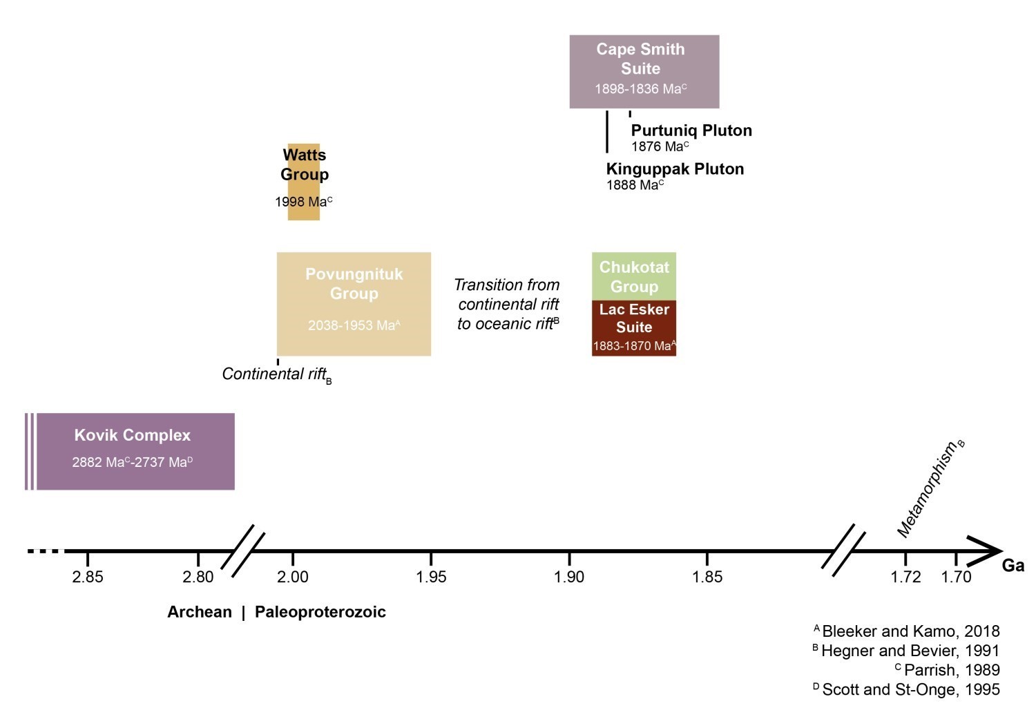
| Bleeker and Kamo, 2018 | Geochronology, geochemistry | Lithostratigraphic reinterpretation of the Ungava Trough |
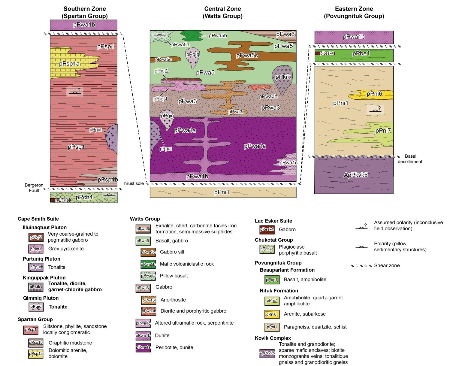
Lithostratigraphy
The study area is located in the eastern part of the Northern Domain, which is located in the central part of the Ungava Orogen (or Trough). Large thrust faults juxtapose the Northern Domain with the Kovik Antiform to the north and the Cape Smith Belt (or Southern Domain) to the south.
The diagram below shows the units forming the three main lithostratigraphic subdivisions of the area, taking into account field relationships, their geographic distribution and their relative importance. Stratigraphic polarities are interpreted and not observed. Interpretations are also based on U-Pb and Pb-Pb ages from literature.
Bedrock
The Kovik Complex (Charette and Beaudette, 2018) groups the oldest rocks in the study area. It outcrops as tectonic slices at the northern edge of the Northern Domain. This unit consists mainly of tonalite, granodiorite and their gneissic equivalents (ApPkov5). The Kovik Complex is interpreted as a window of Archean rocks, equivalent to those of the Superior Craton, within the Ungava Orogen (St-Onge and Lucas, 1992).
Southern Domain
The Povungnituk Group (Bergeron, 1959; Hocq et al., 1994) consists of a volcano-sedimentary package emplaced following the opening of a continental rift in the Superior Province (Hegner and Bevier, 1991). In the study area, this unit consists of two formations: the Nituk Formation garnet-muscovite paragneiss, which has been unconformably deposited on the Kovik margin, and the Beauparlant Formation amphibolite and basalt. These rocks appear as tectonic slices in the northern part of the study area, bordering the Kovik. At the eastern end of the area, paragneiss and amphibolite layers had been mapped by St-Onge and Lucas (1993) as belonging to the Spartan and Watts groups, respectively. Based on petrographic observations, stratigraphic position and radiometric signatures of metasedimentary rocks, these beds are now assigned to the Nituk and Beauparlant formations.
The Chukotat Group (Bergeron, 1959) consists of plagioclase porphyritic basalt (pPch4), the emplacement of which would reflect the transition from a continental rift to an oceanic rift. The morphology of the weakly to undeformed pillows indicates a normal northward polarity. The unit thus represents a normal, homoclinal sequence dipping northward. Ankeratized basalt layers (pPch6) were mapped in 2018 near the Bergeron Fault.
The Lac Esker Suite (Bédard et al., 1984; Picard et al., 1995) consists of mafic to ultramafic sills cogenetic with Chukotat pillow lava, representing the feeder pipes. This unit would be located stratigraphically at the boundary between the Povungnituk and Chukotat groups (St-Onge et al., 2000; Bleeker and Kamo, 2018). Differentiated sills of the Lac Esker Suite cut amphibolite of the Beauparlant Formation.
Northern Domain
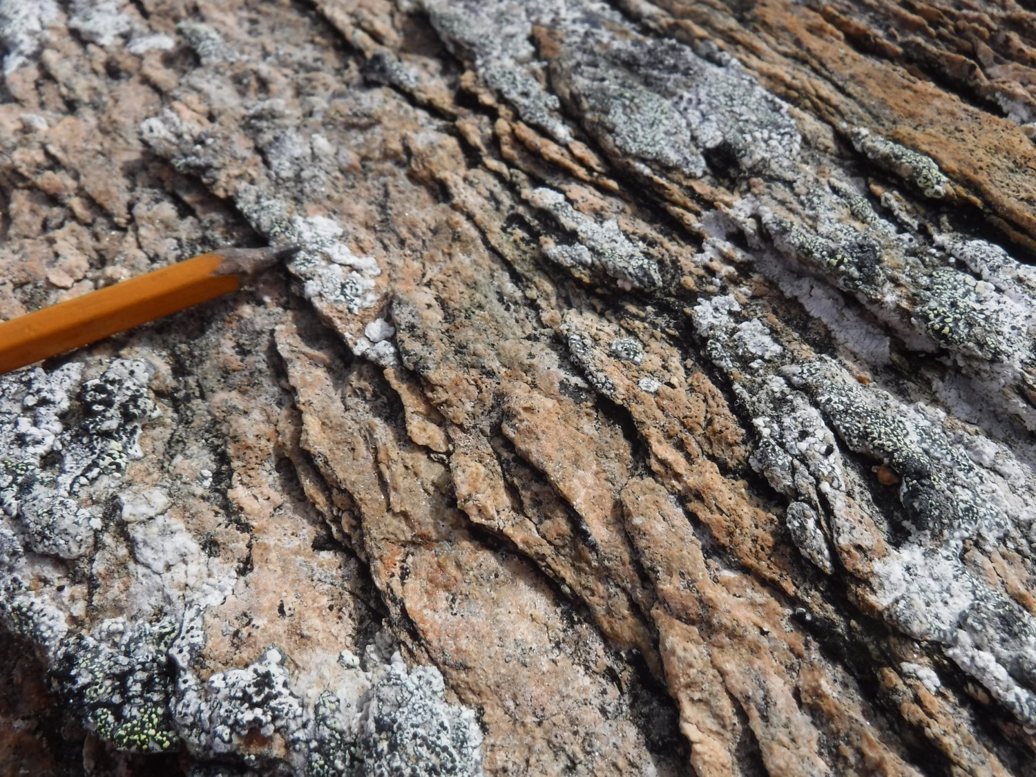
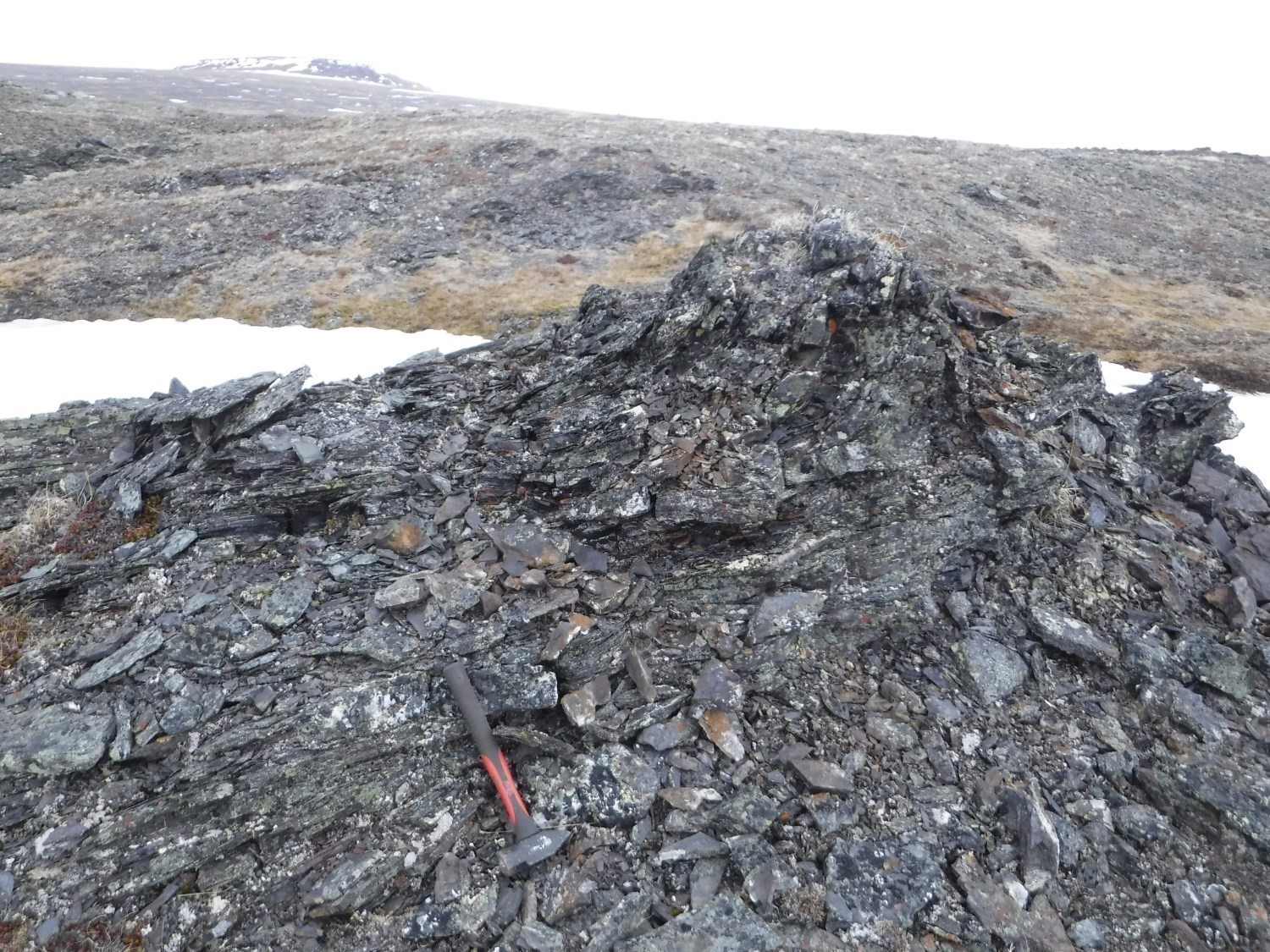
The Spartan Group (Lamothe et al., 1984) refers to a unit consisting of highly deformed phyllite, siltstone and mudrock. Metasedimentary rocks show millimetric to centimetric quartzofeldspathic bands delimited by muscovite-rich planes. Dolomite (pPsp1a) and graphitic mudstone (pPsp1b) were also mapped in 2018. Sparse truncated laminae observed in the SW portion of the Spartan Group (outcrop 18-CB-1060) suggest a normal northward polarity in this area. Undeformed ankerite poikiloblasts north of the Bergeron Fault indicate post-kinematic alteration. The source of sediments that fed this basin is not known. It is structurally underlying the Watts Group and overlying the Chukotat Group.
The Watts Group (Lamothe et al., 1984) consists of mafic to ultramafic intrusive lithologies, as well as a sequence of supracrustal rocks that presents an association suggesting an oceanic origin. Deformed ultramafic facies (pPwa1) consist of peridotite (pPwa1a) and, to a lesser extent, pyroxenite (pPwa1d) and are cut by dunite dykes (pPwa1b). Large bands of altered ultramafic rocks (pPwa1c) were also brought out. The Watts Group main unit consists of a sequence of gabbro (pPwa3) subdivided into several subunits, the most important of which are layered gabbro (pPwa3c) and fine to medium-grained mesocratic gabbro (pPwa3d). A few new subunits of minor importance have been introduced, such as leucogabbro (pPwa3a) commonly associated with speckled gabbro (pPwa3b), which cuts subunit pPwa3c. Garnet gabbro (pPwa3g) and porphyritic diorite (pPwa3h) are found in the northern portion of the Northern Domain. Deformed anorthosite (pPwa3i) cuts the sequence of mafic intrusions. Altered gabbro layers were grouped into subunit pPwa3f. The Watts Group is formed of a summit pile of basalt and synvolcanic gabbro (pPwa5) along with chlorite-actinolite schist interstratified with exhalite, chert and carbonate facies iron formations (pPwa6). This sequence had been described in the western portion of the study area (St-Onge and Lucas, 1993), but work in 2018 identified pillow basalts (pPwa5a) and mafic volcaniclastics (pPwa5b) in the eastern part of the area and uncovered massive sulphide layers associated with iron formations.
Late-Kinematic to Post-Kinematic Units
In earlier work (Lamothe, 2007), late-kinematic to post-kinematic intrusions of the Ungava Orogen had been grouped in the Cape Smith Suite, introduced by Taylor (1982). In the study area, four of these intrusions were formally identified as lithodemes.
The Qimmiq Pluton (pPqiq) is a new unit of deformed tonalite and trondhjemite that intrude both ultramafic rocks and basalts of the Watts Group.
The Kinguppak Pluton (pPkik) is introduced here to designate a unit already mapped by Lamothe et al. (1984), but with a much smaller extension. The foliated, layered and tabular intrusion consists of tonalite, diorite and garnet-chlorite gabbro. It occupies the top of the hill overlooking the western shore of Watts Lake. These lithologies cut cogenetic basalts and gabbros (pPwa5) and layered gabbros (pPwa3) of the Watts Group. Dunphy and Ludden (1998) refer to the U-Pb reanalysis of Parrish (1989) that gave a crystallization age of 1888 Ma.
The Purtuniq Pluton (pPput) is a new unit mapped by Gélinas (1961) near the former Asbestos Hill asbestos mine. This intrusion of undeformed tonalite and quartz diorite poor in ferromagnesian minerals cuts both metasedimentary rocks of the Spartan Group and a peridotite of the Watts Group. The pluton was dated 1876.1 Ma by Parrish (1989).
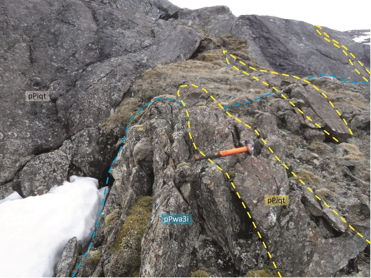
The Illuinaqtuut Pluton (pPiqt) refers to a unit consisting primarily of undeformed pyroxenite (pPiqt1) and a very coarse-grained to pegmatitic gabbro border (pPiqt2). It also contains smaller amounts of altered pyroxenite (pPiqt1a) and massive pyroxenite (pPiqt3). This intrusion was originally mapped by St-Onge and Lucas (1989a) and assigned to the Watts Group. It cuts the Watts Group supracrustal sequence, as well as layered gabbro (pPwa3d) and anorthosite (pPwa3i) in the western part of the study area.
Geophysical Signature and Surface Geology

In the study area, there is not always an exact match between magnetic highs and lithological units having high magnetic susceptibility. A good example is the highly magnetic ENE-oriented ridge in the centre of the opposite figure. Field work shows that this anomaly does not entirely correspond to ultramafic rock units. The ESE and ENE ends of this ridge, characterized by high magnetic susceptibility and sharp borders, are effectively centred on ultramafic rock outcrops. In the centre of the ridge, however, the magnetic intensity is lower and less contrasting. Outcrops above this portion of the anomaly consist of gabbro and basalt. These observations can be explained by the presence, in depth, of ultramafic rocks under a thin layer of gabbro and basalt of lower magnetic susceptibility.
Structural Geology
Deformation Events
The Northern Domain is characterized by polyphase deformation. Three deformation events were identified in the study area (St-Onge and Lucas, 1993).
Event D1
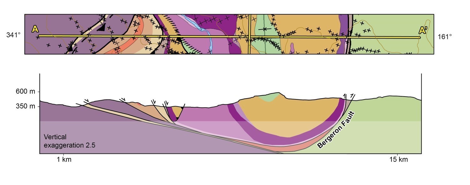
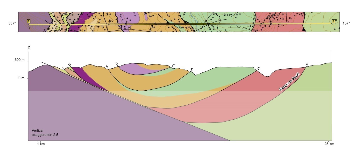
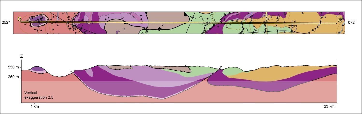
The main foliation, assigned to the D1 deformation phase, is recognized in most of Northern Domain outcrops. It is defined by the alignment of micaceous minerals and amphiboles, and locally by compositional banding. Bedding, generally visible in metasedimentary rocks of the Spartan Group, is transposed into this foliation’s plane. On several outcrops, foliation contains a mineral lineation or gliding striations interpreted as synchronous to the D1 deformation. This event would be related to the beginning of the compression regime during the Superior and Sugluk microcontinent collision (Corrigan et al., 2009). It is responsible for major tectonic features in the study area, namely the Kovik-Nituk decollement and associated slice imbrications, the Bergeron Fault, and Watts Group delamination through a series of internal thrusts.
Event D2
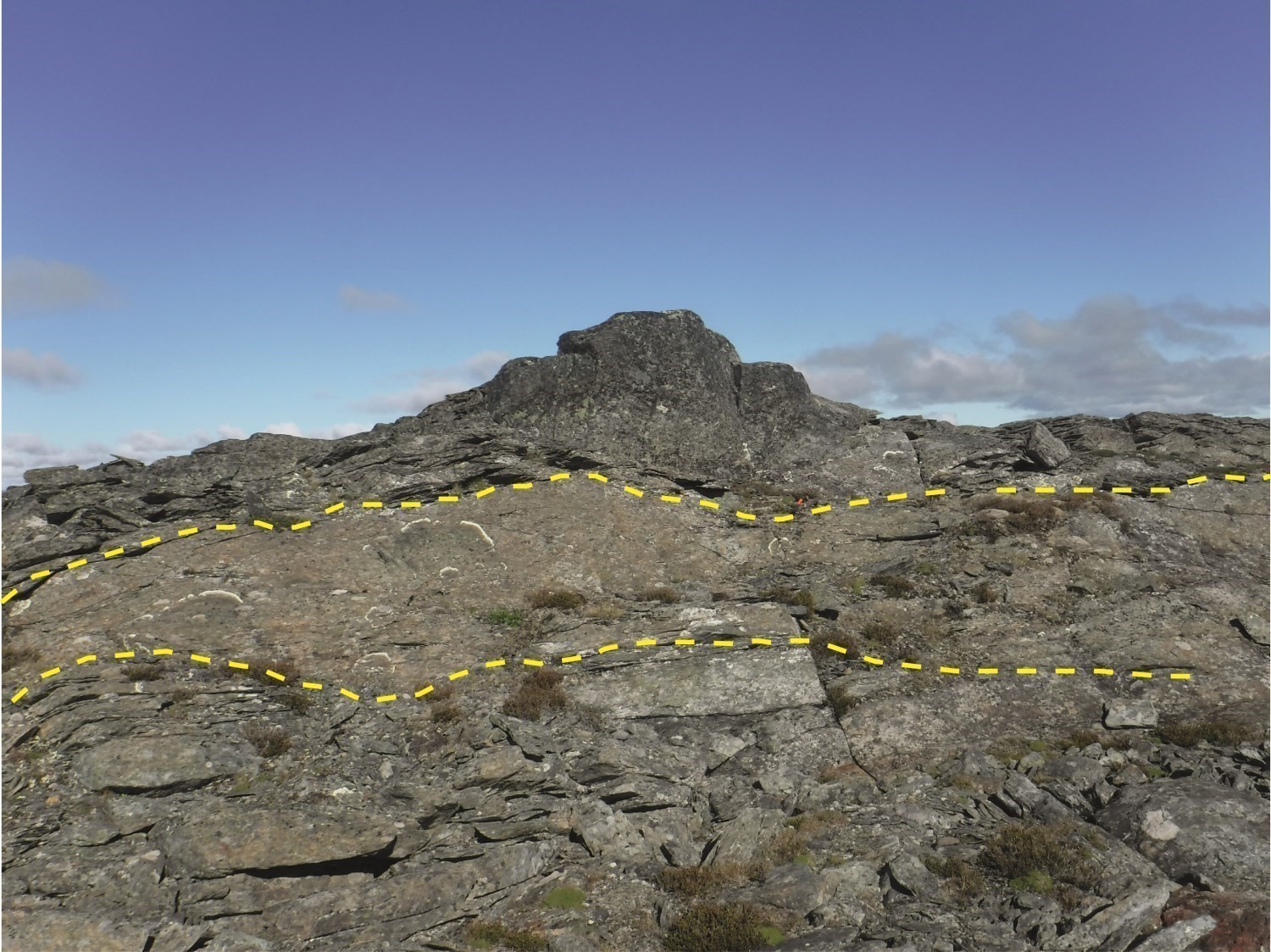
Thrust faults having southward movement and the main foliation were then folded during the D2 deformation. The main structure associated with D2, initially described by Gélinas (1961), is a km scale (P2), open and upright synform having a variable dip. The axial trace of this structure, generally oriented E-W, was recognized over 55 km from the west of Watts Lake to the Kovik Complex to the east where the fold is cut by a N-S shear zone. Watts Group basalt pillows observed in the SW portion of the mapped area indicate normal polarity of the sequence northward, while those in the north-central zone show normal southward polarity. This synform is largely responsible for the distribution pattern of units at the regional scale, particularly tectonic thickening of the Watts Group (see AA’, BB’ and CC’). The synform structure can be divided into two segments separated by the axial trace of a N-S P3 antiform centred on Spartan Group rocks east of Watts Lake. The western segment represents a synclinorium shallowly dipping westward, which northern flank is obliterated by shear zones. The segment is characterized by a double-dip E-W synform. This structural basin contains, in the centre, units of the Watts Group bordered to the west by the Spartan Group and to the east by the Nituk Formation. Locally, a few outcrops contain a crenulation cleavage parallel to axial planes of parasitic folds that affect the main foliation and are subparallel to the large synform.
Since both D1 and D2 deformation phases are coaxial, they may have formed in a deformation continuum.
Event D3
A third event (D3) is defined by P3 open, upright folds oriented N-S orthogonally to thrust faults associated with D1 and to the E-W axial trace of P2 folds. First-order P3 folds are responsible for dip inversions of P2 folds, resulting in structural level variation along the axial trace of the large P2 synform. Locally, some outcrops show N-S open folds subparallel to large N-S folds drawn on the map.
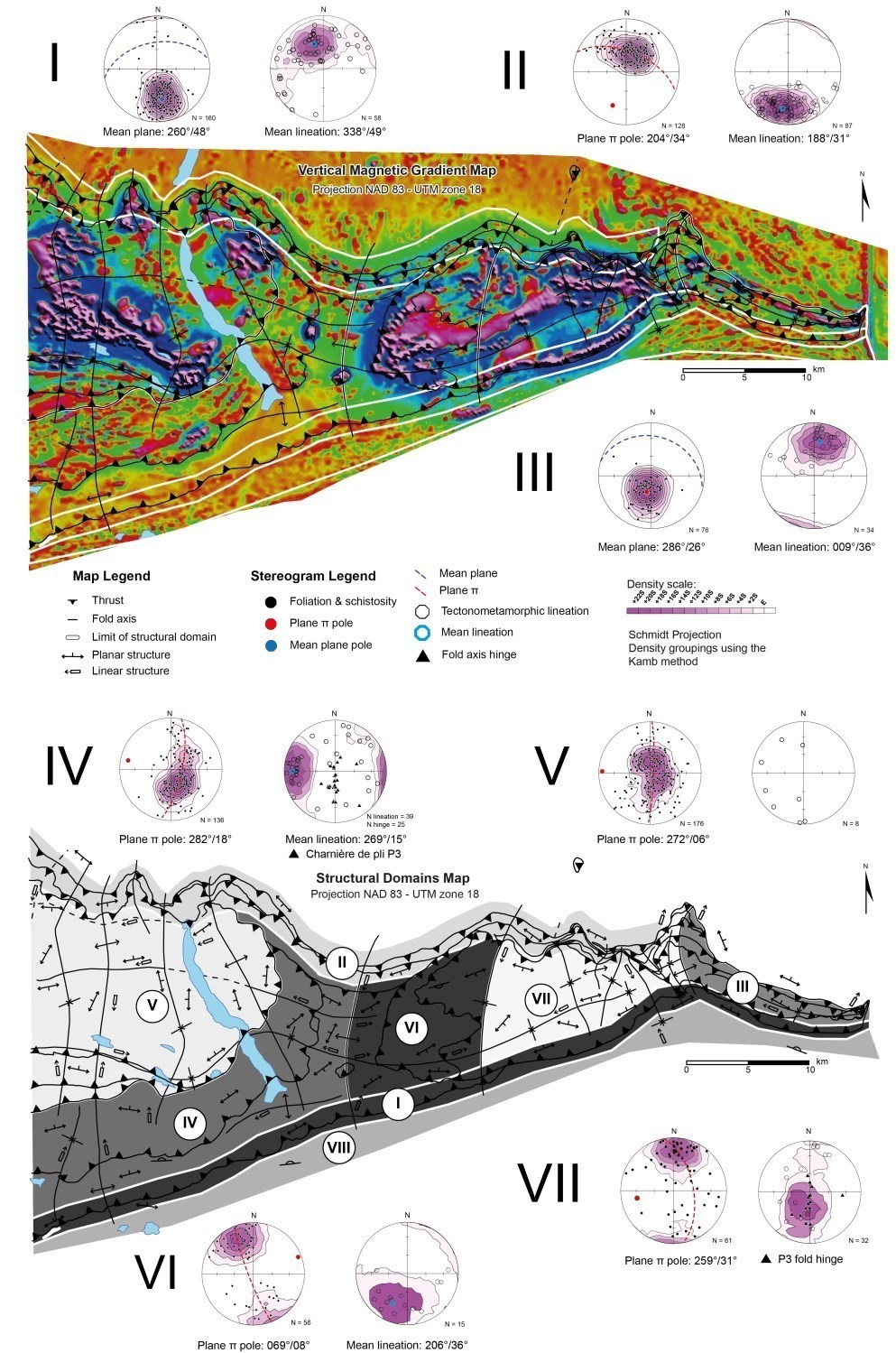
Structural Domains
The area mapped in the summer of 2018 is divided into eight structural domains, named I to VII.
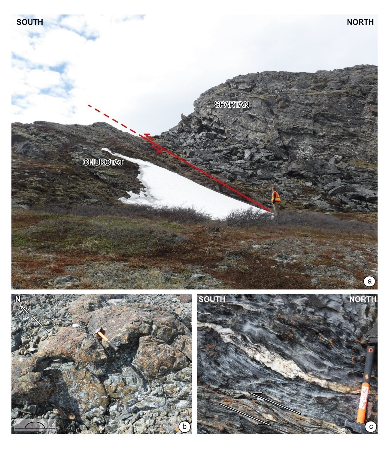
Domain I coincides with the Bergeron Fault influence zone, which represents the contact between the Northern and Southern domains. The Watts and Spartan groups overthrust Chukotat Group basalts to the south. The mean plane of the main foliation is oriented 260°/48° and has a northward dip. High-plunge tectonic lineations are compatible with reverse movement along the fault. A few shallower-plunge lineations show strike-slip movements, probably later. The Bergeron Fault stands out on satellite images (Pleiades) as it juxtaposes Chukotat Group orange basalts with Spartan Group greyish phyllites. In the field, its position is marked by strong lithological and topographic contrasts. The influence of the Bergeron Fault is manifested in Chukotat Group basalts up to ~1 km from it by the presence of sheared bands and carbonate-filling brecciated zones.
Domain II is the influence zone of the Northern Domain thrust sole over the Kovik Antiform. Planar and linear structures having southward dip and plunge thus define the north flank of the large P2 synform, the axial trace of which occupies the central part of the Watts Group to the south. The open and upright P3 folds are responsible for the winding trace of the contact between the Kovik Complex and Nituk Formation and the variable orientation of the main foliation. The pole of the great circle formed by S1 foliation poles (great circle pole at 204°/34°) is roughly parallel to mineral lineations having a shallow southward plunge (188°/31°).
Domain III is an eastward extension of domains II and VII. It represents the eastern extension of the large P2 synform which forms the core of domains V, VII and VII farther west. Domain III is distinguished by the northward reversal of lithological units’ dip and S1 foliations on the northern flank of the synform, with the sequence of the Povungnituk and Watts groups being reversed and having southward polarities, but northward dips. Eastward, the axial trace of the P2 synform abruptly rotates northward as it approaches the N-S shear zone visible on the magnetic map, marking the eastern limit of the Northern Domain. To the south, a P2 antiform was drawn from the distribution of Nituk Formation sandstone units. Domain III is not affected by late undulating P3 folding observed farther west in domains II and VII. The mean plane of the S1 main foliation is oriented 286°/26°. The lineation orientation at 009°/36° is close to the mean main foliation plane dip and is compatible with a main N-S stress during D1.
Domain IV forms a P2 synclinorium dipping moderately westward on the western flank of a P3 antiform that coincides with the Spartan Group N-S segment. On the stereogram, poles of the main foliation are distributed in a great circle which pole represents the theoretical axis of the P2 fold (282°/18°). Secondary P3 fold axes were also plotted on the linear structure stereogram. These folds have moderately to steeply dipping hinges and decametric to hectometric wavelengths.
Domain V is characterized by a strong dispersion of shallow-dip planar structures. Several P3 folds of kilometric wavelength are superimposed on the P2 synclinorium, which accentuates the dispersion of the main foliation. This domain could be subdivided into multiple subdomains from the axial traces of P3 folds.
Domain VI is located on the eastern flank of the large N-S antiform revealing rocks of the Spartan Group. It also includes the western portion of the P2 double-dip synform which has a shallow eastward dip and characterize the centre of the Watts Group in this area. The theoretical axis of this upright and open synform, defined by the pole of the great circle formed by the poles of the main foliation, is oriented 069°/08°. The P2 synform hinge zone does not outcrop much, which explains the small number of measurements from this area. The shallow dip of the P2 synform implies that Spartan Group rocks are at a shallow depth below Watts Group units.
Domain VII represents the eastern closure of the P2 double-dip synform. At the centre are mafic and ultramafic rocks of the Watts Group, bounded to the north and east by the Nituk Formation and to the south by the Spartan Group. The dispersion of the main foliation is greater than in domain VI because of the influence of P3 folds on the northern flank of the synform. The pole of the great circle containing foliation poles is oriented 259°/31°, compatible with a synform having a moderate westward dip.
Domain VIII coincides with the summit part of the Chukotat Group. It shows a homoclinal volcanic sequence oriented ENE-WSW and having a moderate dip and normal northward polarity. At the extreme east of the mapped area, elongated ridges of high magnetic susceptibility define a fold with an axial trace oriented 280º. Bedding and foliation measurements from the Sigeom compilation map indicate that it is a synclinal synform structure dipping towards the WNW.
Metamorphism
Our observations regarding metamorphism of the Northern Domain confirm the work of Gélinas (1961), who traced the biotite and garnet isograds, and the more in-depth study of St-Onge and Lucas (1993).
Greenschist Facies
South of the Northern Domain, Chukotat Group basalts have an actinolite-chlorite-epidote mineral assemblage indicating lower greenschist facies low-temperature metamorphism. Chlorite-felted clusters and actinolite prisms align in the plane of the main E-W schistosity visible near the Bergeron Fault.
Micaceous planes of Spartan Group phyllites are mostly composed of muscovite and trace biotite (Gélinas, 1961), indicating progressive metamorphism to the upper greenschist facies. Quartz and feldspar are even grained. This observation, combined with the absence of chessboard extinction or grain border migration, is characteristic of a static recrystallization of felsic phases consistent with low temperature metamorphism. Micas are weakly chloritized.
Amphibolite Facies
In the central part of the map, hornblende prisms highlight the foliation in Watts Group gabbros. Zoisite and, to a lesser extent, pistachite completely or partially replace plagioclase. Actinolite rods develop randomly, involving post-kinematic retrogressive metamorphism.
Garnet appears near the northern boundary of the Northern Domain, in melanocratic gabbro of the Watts Group, as well as in the Kinguppak Pluton. Euhedral porphyroblasts cut the main S1 foliation or have a slight rotation, involving a late metamorphic episode. Garnet is commonly retrograded to chlorite.
North of the Northern Domain, Nituk Formation paragneiss contain garnet and muscovite (Gélinas, 1961; Lucas and St-Onge, 1993), which is rather compatible with the middle amphibolite facies.
Overall, the metamorphic gradient thus increases northward and eastward.
Economic Geology
Previous mapping work by the Geological Survey of Canada (Lamothe, 2007; St-Onge and Lucas, 1989a, b) mainly focused on the geodynamic understanding of the Ungava Orogen. No sampling or lithogeochemical analysis of mineralized or altered zones of the mapped area appears to have been conducted during this work (St-Onge and Lucas, 1993). Prior to our work, only one significant asbestos mineralization (Asbestos Hill Mine) was known in the eastern portion of the Northern Domain. The summer 2018 work identified 23 prospective zones for the following types of mineralization:
- stringer copper mineralization in supracrustal rocks and ultramafic intrusions of the Watts Group;
- Ni-Cu-PGE-Au magmatic and hydrothermal mineralization associated with alteration zones in mafic and ultramafic intrusions;
- exhalative sulphide mineralization;
- chromite mineralization in ultramafic rocks of the Watts Group;
- Fe-Ti-V mineralization in layered mafic intrusions of the Watts Group;
- base and precious metal mineralization associated with the Bergeron Fault.
The table of mineralized zones below presents analytical results for known mineralized zones in the area, including fifteen (15) new mineralized zones discovered as part of our work and one known mineralized zone.
| Name | Contents |
|---|---|
| Stringer copper mineralization | |
| Cool-Kuluk | 28 ppm Ag (G); 262 ppb Au (G); 367 ppm Co (G); 29 200 ppm Cu (G); 841 ppm Zn (G) |
| Fe-Ti mineralization in mafic intrusions | |
| Patapouf | 3260 ppm V (G) |
| Fe-Ti mineralization in gabbros and anorthosites | |
| 5062 | 1450 ppm V (G) |
| CL2216 | 1410 ppm V (G) |
| Machine | 1760 ppm V (G) |
| Naatoraliknatsisit | 108 ppm Co (G); 271 ppm Cu (G); 162 ppm Ni (G); 1970 ppm V (G) |
| SM6180 | 593 ppm Cr (G); 1550 ppm V (G) |
| Magmatic Ni-Cu mineralization associated with mafic-ultramafic intrusions | |
| Crampon | 3800 ppm Ni (G) |
| Ouiche | 990 ppm Co (G); 22 100 ppm Cu (G); 4690 ppm Ni (G) |
| Chromite mineralization in mafic and ultramafic rocks | |
| Boss-Stone | 15 300 ppm Cr (G) |
| SL-4010 | 51 800 ppm Cr (G) |
| Satch | 7500 ppm Cr (G) |
| Slaf | 7450 ppm Cr (G) |
| Venière | 7260 ppm Cr (G) |
| Exhalative sulphide mineralization | |
| Kangillialuk | 5 ppm Ag (G); 5 ppm Ag (G); 172 ppb Au (G); 1400 ppm Cu (G); 162 ppb PGE (G); 402 ppm Ni (G); 1150 ppm Zn (G) |
| Name | Contents |
|---|---|
| MINE ASBESTOS HILL | 13.16 proven Mt of undetermined-content chrysotile asbestos. Cross-type transverse fibres are 4.5 to 6 mm long. The fibre is said to be of excellent quality and reaches locally several centimetres in length. No assessment work was done on this deposit, which was only mined seasonally. |
(G): Selected sample
The table of lithogeochemical analyses of metals of economic interest provides the location, description, and analytical results for 237 samples selected to assess the economic potential of the area.
Discovery of Stringer Copper Mineralization in the Watts Group
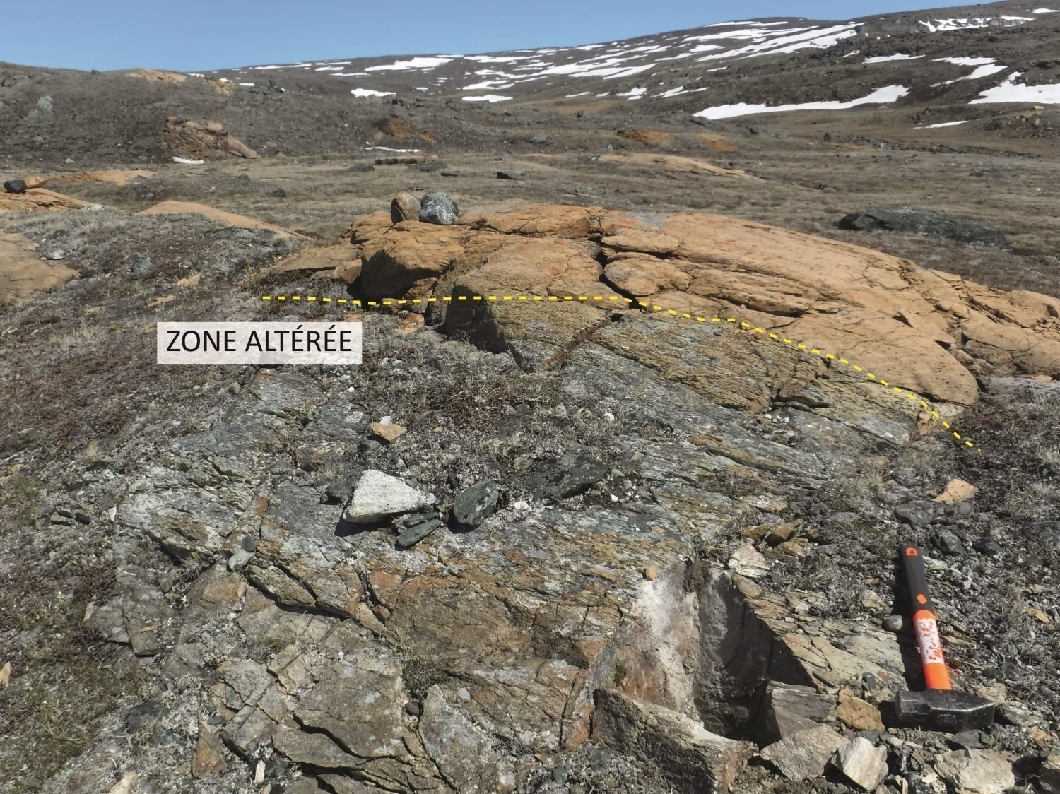
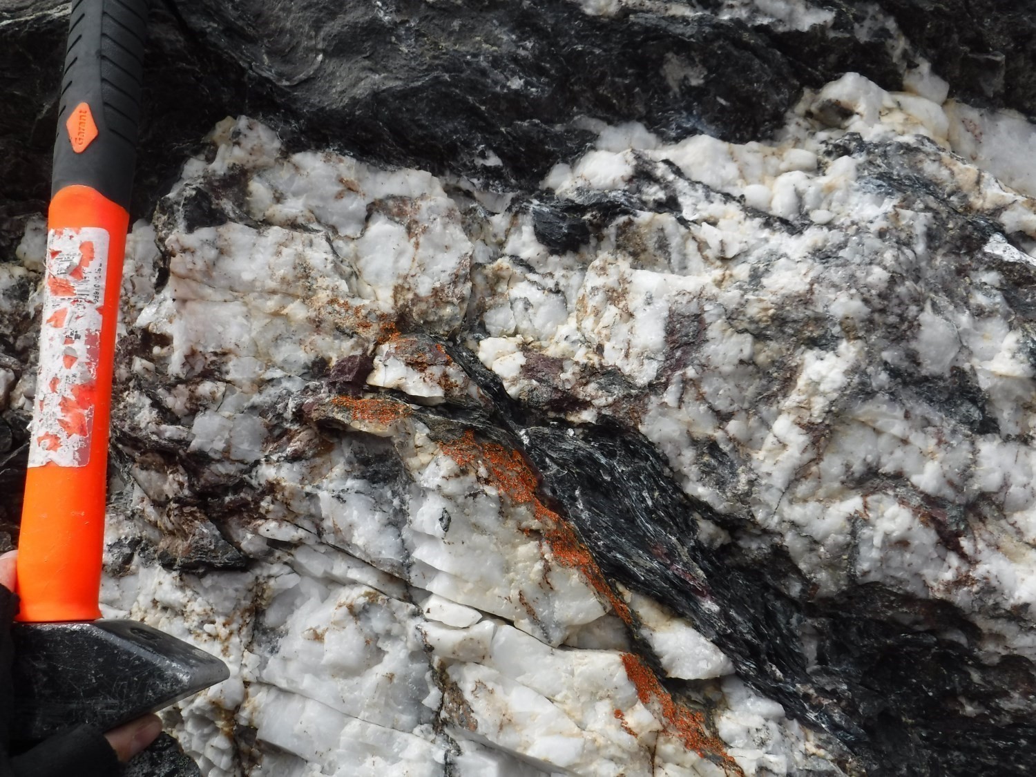
 Two prospective zones for stringer copper mineralization (interactive map) have been defined in layered gabbros (pPwa3c) and volcanic rocks (pPwa5) of the Watts Group. In both cases, there is evidence of widespread chlorite alteration locally associated with sericite and, very locally, fuschite.
The Tungujuqaupaq prospective zone is defined by a network of millimetric calcite veinlets containing traces of chalcopyrite and malachite. The veinlet network cuts both layered gabbro and pillow basalt of the Watts Group.
The Isaroq prospective zone (Cool-Kuluk mineralized zone) is associated with thrust zones linking highly deformed volcanic units (pPwa5) and ultramafic intrusive units (pPwa1) of the Watts group. Sericitized felsic dykes of the Qimmiq Suite (pPqiq) intrudes into the contact zone. Mineralization consists of sulphide (pyrrhotite-chalcopyrite) veins and decimetric clusters, as well as fine chalcopyrite dissemination in these lithologies.
Discovery of Cr-Ni ± PGE ± Au Mineralization Associated with Alteration Zones in Ultramafic Intrusions of the Watts Group
 Ultramafic intrusions of the Watts Group are locally altered (pPwa1c). Serpentinization affects peridotites and dunites to varying degrees, which are also carbonated (ankerite) and, in places, silicified. Some samples containing chromite yielded anomalous to showing values of chromium and nickel that would be magmatic in origin. Anomalous gold contents, such as in the Crampon mineralized zone and in sample 18-CL-2226-B1 (236 and 705 ppb Au) are also reported, especially near deformation zones and the thrust sole of the sequence. This may indicate potential for gold mineralization associated with listwaenites.
Watts Group mafic intrusions are also locally altered (pPwa3f). Highly chloritized ferromagnesian phases, sericitized plagioclase and the presence of interstitial carbonates are confirmed in thin sections. The Ouiche mineralized zone is characterized by semi-massive sulphide mineralization associated with a stockwerck of quartz veinlets. Mineralization, composed of pyrrhotite and chalcopyrite, is spatially associated with altered and sheared anorthosite (Manniit prospective zone).
Six prospective zones of this type have been identified: Aningaasat 1 (293 ppb PGE and 2070 ppm Cr), Aningaasat 2 (2010-5560 ppm Cr and 113-764 ppb PGE), Aningaasat 3 (93-132 ppb PGE, 2240-2340 ppm Cr and 316-601 ppm Ni), Aningaasat 4 (4370 ppm Cr, 1950 ppm Ni, 170 ppb Au and 998 ppm As), Isuqtaq (705 ppb Au, 2000-3800 ppm Ni and 1350-2270 ppm Cr) and Manniit (1.72-2.21% Cu, 1980-4690 ppm Ni and 407-990 ppm Co).
Discovery of Exhalative Sulphide Layers in the Watts Group, Nituk Formation and Spartan Group
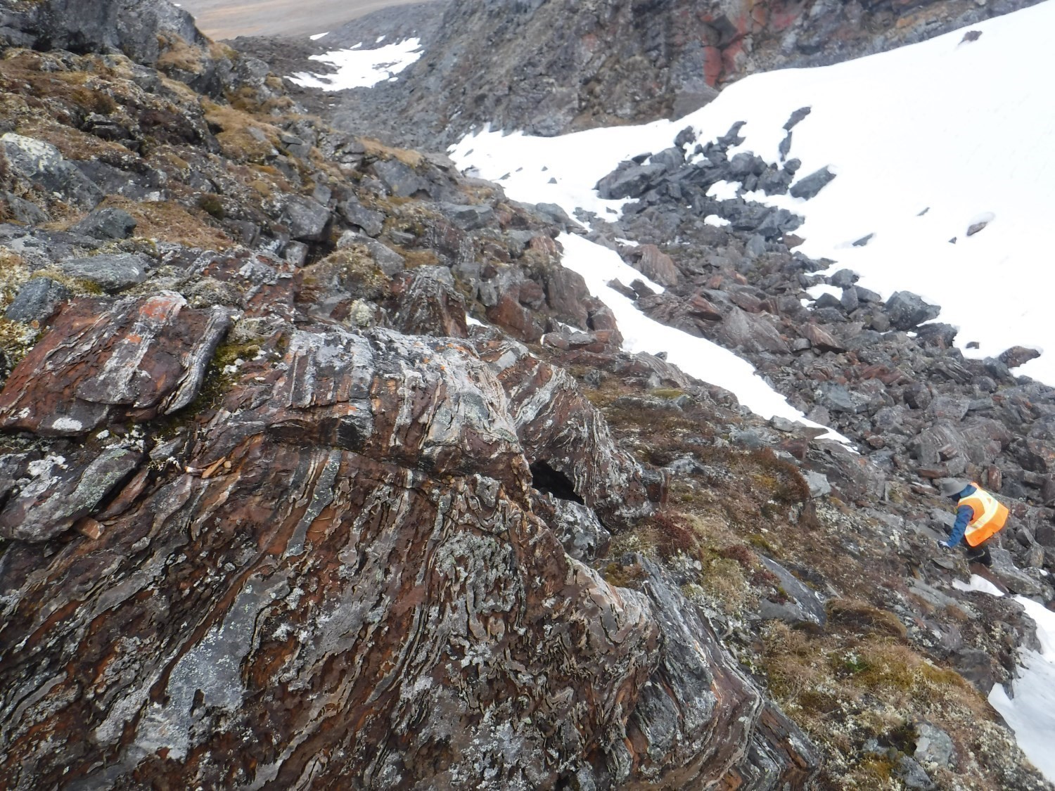
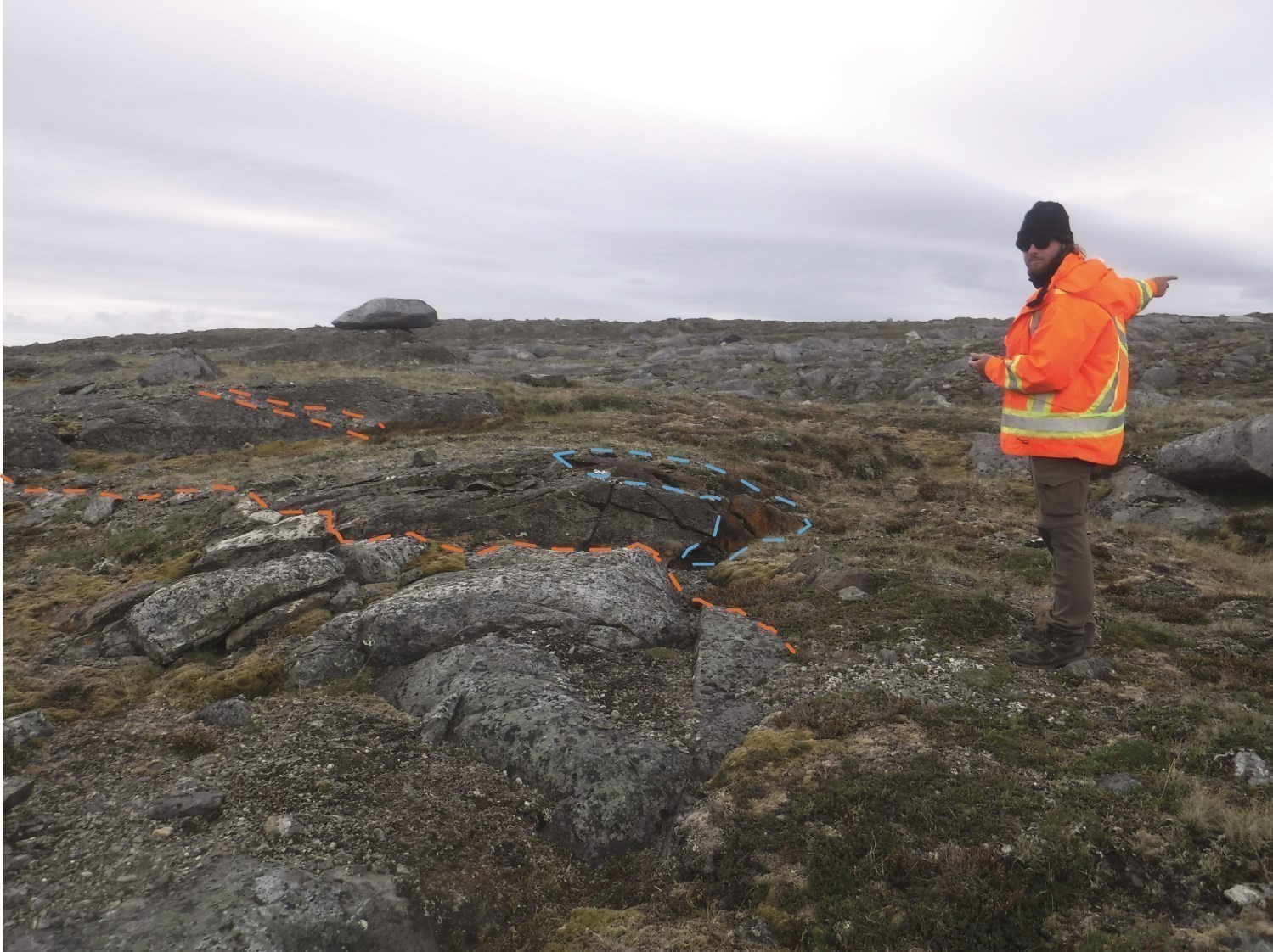
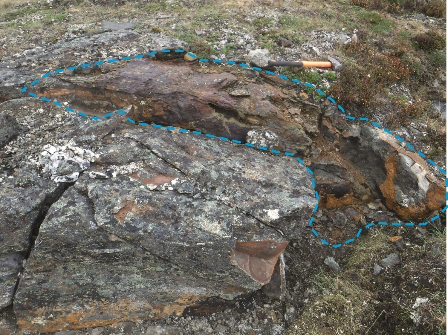
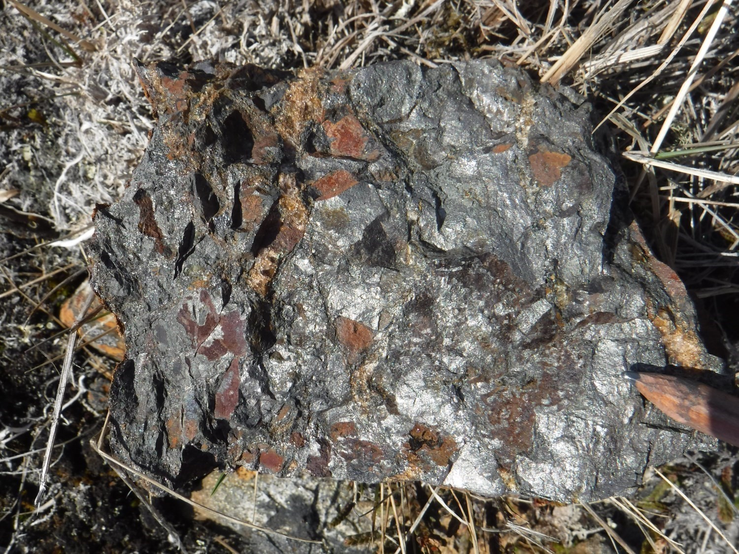 The summer 2018 mapping work led to the discovery of massive and semi-massive sulphides (interactive map). With no exhalative layers being reported in the Watts Group in the past, these units and associated iron formations (pPwa6) are first-order exploration targets. These mineralized levels are likely to be located at the top of the Watts Group. They are characteristic of emplacement in a deep marine environment, consistent with the presence of pillow basalt (pPwa5a). Metre-thick mineralized bands (pyrite-pyrrhotite ± chalcopyrite) are interstratified with layers of metamorphosed chert (quartzite), ankerite-hematite iron formation and chlorite-amphibole schist.
Three prospective zones have been delineated: Tuktuk 1 (47-172 ppb Au, 3-5 g/t Ag, 86-162 ppb PGE, 309-2090 ppm Cu, 669 ppm Ni and 560-1440 ppm Zn), Tuktuk 2 and Tuktuk 3.
Two massive sulphide breccias are interstratified with highly deformed paragneiss and garnet amphibolite of the Nituk Formation. Two prospective zones have been identified in the northern thrust zone of the Northern Domain (Tuktuk 4 and Tuktuk 5, 546-850 ppm Cu, 813-829 ppm Ni, 522-546 ppm Zn).
Semi-massive sulphide breccias were found interstratified with Spartan Group cherty and graphitic mudrock (pPsp1b). The breccia consists of mudrock angular fragments and semi-massive pyrrhotite ± pyrite ± chalcopyrite fragments (Tuktuk 6, 271-588 ppm Cu, 292-267 ppm Ni, 1650-2010 ppm Zn and 514-632 ppm V).
Discovery of Cr Magmatic Mineralization Associated with Ultramafic Intrusions of the Watts Group
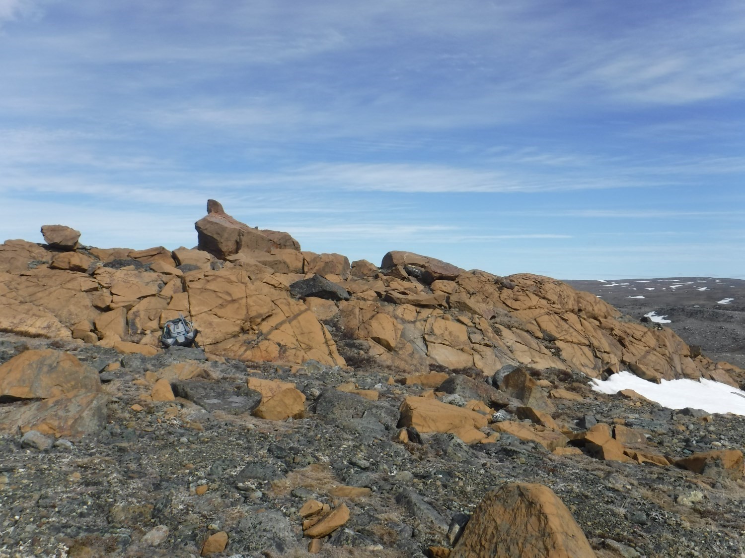
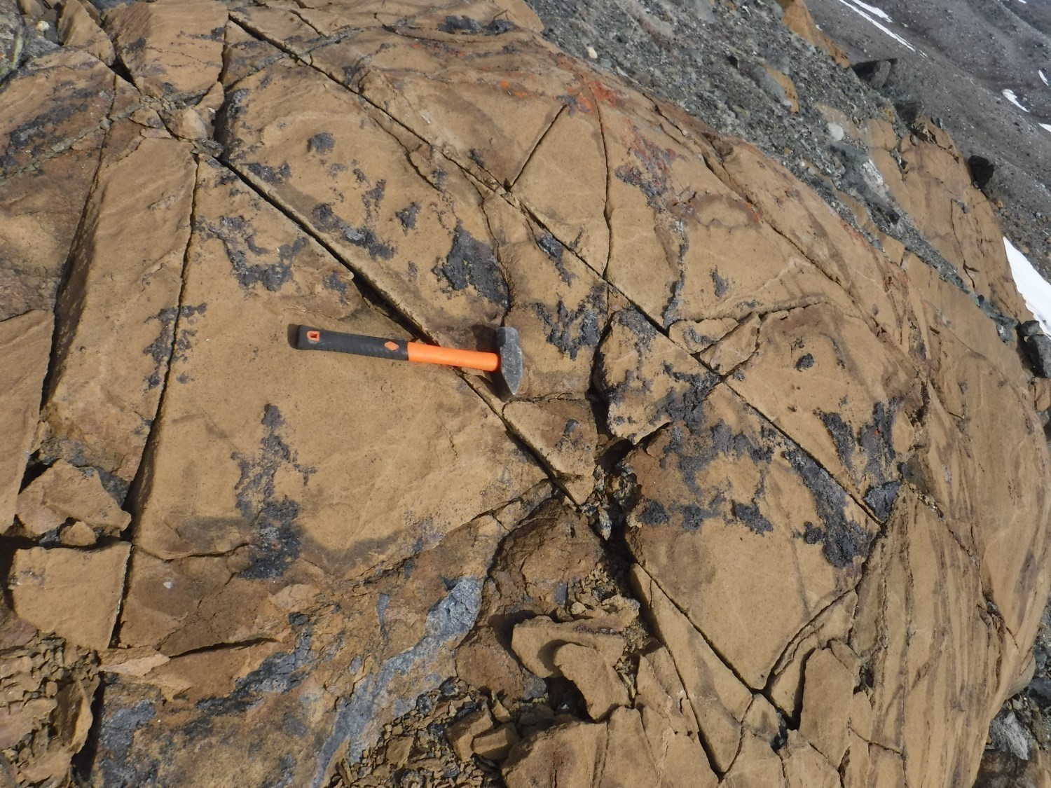

Buff-coloured dunites of the Watts Group (pPwa1b) are particularly visible on satellite imagery (Pleiades). They have potential for layered and podiform chromium mineralization. Three prospective zones have been identified (interactive map).
Chromite mineralization mainly forms magmatic layers in dunite. Chromite-magnetite laminae are a few millimetres thick and repeat with a spacing of a few centimetres. Two prospective zones for this stratiform mineralization were identified: Kajuq 2 (3040-5010 ppm Cr, 408-1560 ppm Ni and 45.7 ppb total PGE) and Kajuq 3 (915-2360 ppm Cr, 640-2030 ppm Ni and 55 ppb Au).
The Kajuq 1 prospective zone (3150-51 800 ppm Cr) rather is a podiform mineralization.
New Fe-Ti-V Mineralization Associated with Layered Mafic Intrusions of the Watts Group
The Watts Group mostly consists of layered gabbro (pPwa3c). Within these intrusions, magnetite pyroxenite bands a few centimetres to a few metres thick were sampled. Analyses revealed anomalous to showing vanadium contents. The vanadium-bearing phase remains to be determined. A fine dissemination of trace secondary sulphides (pyrite, pyrrhotite and chalcopyrite) is superimposed on magnetite mineralization.
Three prospective zones (interactive map) associated with this mineralization were identified: Kingulialuq 1 (1440-3260 ppm V), Kingulialuq 2 (1092-1860 ppm V) and Kingulialuq 4 (486-1200 ppm V, 323-649 ppm Cu, 105 ppm Co).
New Base and Precious Metal Mineralization Associated with the Bergeron Fault
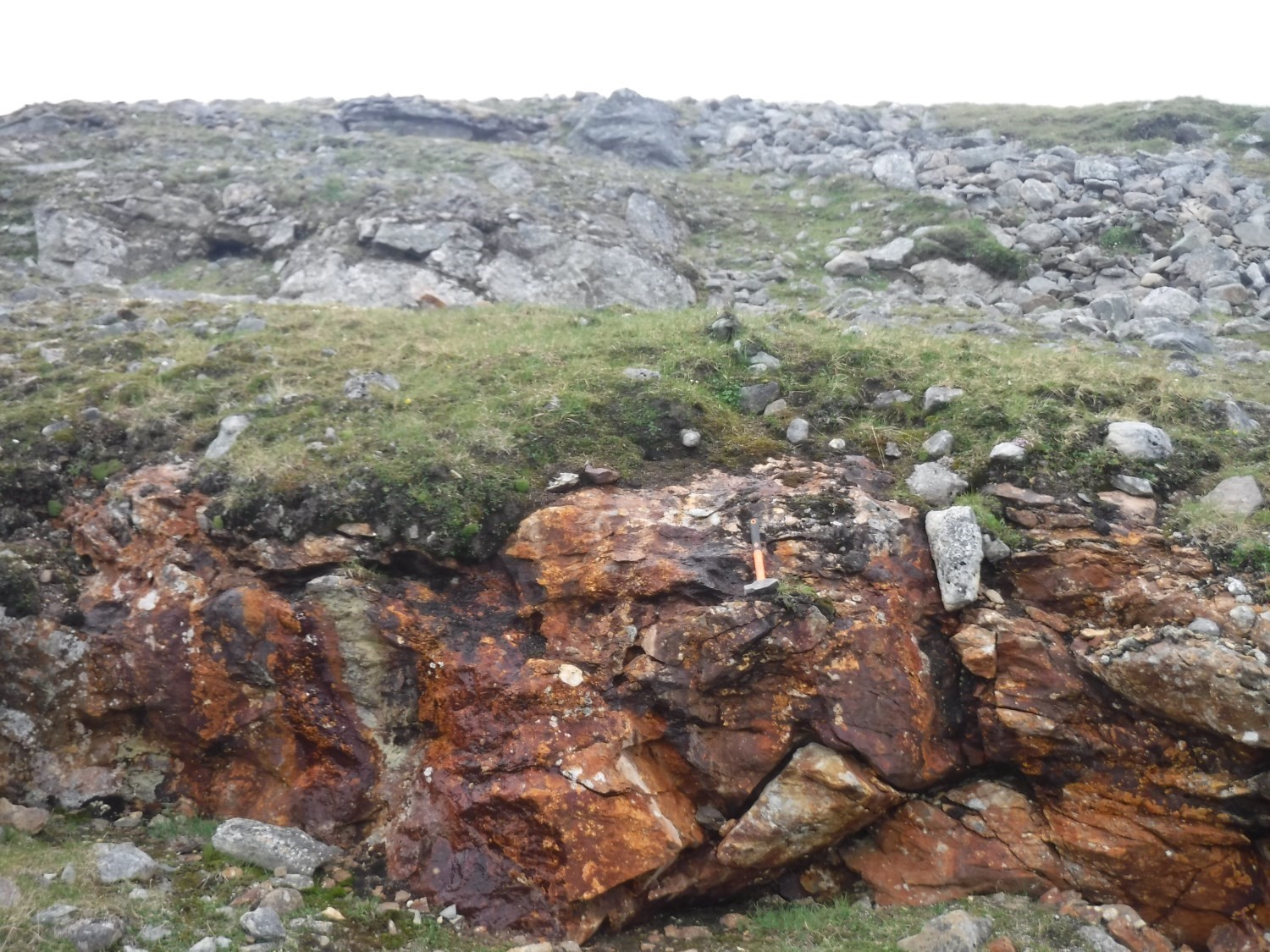
Spartan Group metasedimentary rocks show ankerite alteration throughout the area mapped in 2018. Ankerite occurs as syn-kinematic to late-kinematic poikiloblasts. Alteration is particularly important at the edge of the Bergeron Fault, where it is associated with a system of early quartz-hematite veins. A fine pyrite-pyrrhotite mineralization (trace to a few percent) is superimposed on the alteration as dissemination in metasedimentary rocks or vein walls.
The Bergeron prospective zone (410 ppb Au, 345 ppm Zn, 502 ppm Ba and 28 ppm W) was defined along this fault.
Conclusion
The work carried out in the summer of 2018 helped to clarify and, in several cases, define mineral potential for several types of mineralization:
- magmatic mineralization in mafic and ultramafic intrusive rocks of the Watts Group;
- hydrothermal mineralization in mafic and ultramafic intrusive rocks of the Watts Group and Illuinaqtuut Pluton, as well as in volcano-sedimentary sequences of the Watts and Spartan groups;
- exhalative mineralization in volcano-sedimentary sequences of the Watts and Spartan groups and Nituk Formation.
The geological portrait of the region has also been refined by:
- the introduction of new subdivisions in Watts Group gabbros;
- individualizing intrusions from the Cape Smith Suite;
- the characterization of alteration facies in mafic and ultramafic intrusions of the Watts Group and Illuinaqtuut Pluton.
More work needs to be done to:
- specify the kinematics of the many deformation zones, including the N-S oriented shear zone at the eastern edge of the study area;
- determine the origin of magnetic anomalies in certain zones of the Nituk Formation, where samples show very low magnetic susceptibility;
- deepen the characterization of ultramafic rock alteration facies, particularly near the northern boundary of the area which appears to be conductive to the presence of listwaenites;
- identify the source(s) of Spartan Group metasedimentary rocks.
| Authors | Guillaume Mathieu, Eng., M.Sc. guillaume.mathieu@mern.gouv.qc.ca Mélanie Beaudette, GIT, B.Sc. Melanie.Beaudette@mern.gouv.qc.ca |
| Geochemistry | Fabien Solgadi, P.Geo., Ph.D. |
| Geophysics | Siham Benahmed, GIT, M.Sc. Rachid Intissar, P.Geo., M.Sc. |
| Potential assessment | Hanafi Hammouche, P.Geo., M.Sc. Guillaume Mathieu, Eng., M.Sc. Mélanie Beaudette, GIT, B.Sc. |
| Logistics | Clotilde Duvergier, GIT, B.Sc. |
| Geomatics | Karine Allard, geomatics technician |
| Template and content compliance | François Leclerc, P.Geo., Ph.D. |
| Coaching/mentoring and critical review | James Moorhead, P.Geo., M.Sc. |
| English version | Céline Dupuis, P.Geo., Ph.D. |
| Organism | General Direction of Géologie Québec, Ministère de l’Énergie et des Ressources naturelles, Government of Québec |
Acknowledgements:
This Geological Bulletin was made possible through the cooperation of many people who have been actively involved in the various stages of the project. We would like to thank geologists and engineers Carl Bilodeau, Charles Verreault-Lemieux, Sacha Lafrance, Sacha Marier-Boston, Thomas Debruyne, as well as students Alexandra Paré, Carl-Frédéric Chouinard, Eve Cloutier, François Fournier-Roy, Mahdi Lakhal and Tristan Joubarne. Field transportation was provided by Héli Express. Pilots Yann Delage, Yancy Yergeau and Richard Potvin, and mechanics Jean-Étienne Chassé and Ruslan Omarov performed their work effectively and professionally. We would also like to acknowledge the reception of the Baie Déception team from the Glencore company, especially Nancy, Alain Poirier, Donald Michaud and the harbour mascot, dog Patapouf.
References
Publications Available through Sigéom Examine
Bergeron, R. 1959. Rapport préliminaire sur la région des Monts Povungnituk, Nouveau-Québec. MRN. RP 392, 11 pages, 1 plan.
Charette, B., Beaudette, M., Parent, M., Paquette, L. 2018. Géologie de la région du Cap Wolstenholme, Orogène de l’Ungava, Province de Churchill, sud-est d’Ivujivik, Québec, Canada. MERN. BG 2018-03, 2 plans.
Gélinas, L. 1961. Rapport préliminaire sur la région du lac Watts, Nouveau-Québec. MRN. RP 471, 15 pages, 1 plan.
Hocq, M., Verpaelst, P., Clark, T., Lamothe, D., Brisebois, D., Brun, J., Martineau, G. 1994. Géologie Du Québec. MRN. MM 94-01, 172 pages.
LAMOTHE, D. 2007. LEXIQUE STRATIGRAPHIQUE DE L’OROGÈNE DE L’UNGAVA. Ministère des Ressources naturelles et de la Faune, Québec; DV 2007-03, 66 pages, plan.
Lamothe, D., Picard, C., Moorhead, J. 1984. Région du lac Beauparlant, bande de Cap Smith-Maricourt. MRN. DP-84-39, 2 plans.
Picard, C., Tremblay, C., Giovenazzo, D., Thibert, F. 1995. Pétrographie, géochimie et gîtologie des roches plutoniques ultramafiques et mafiques protérozoïques de la partie centrale de la Fosse de l’Ungava : implications sur la distribution des éléments du groupe des platinoïdes. MRN. MB 94-30, 375 pages, 5 plans.
Other Publications
Bédard, J.H., Francis, D.M., Hynes, A.J., Nadeau, S. 1984. Fractionation in the feeder system at a Proterozoic rifted margin. Canadian Journal of Earth Sciences; volume 21, pages 489–499. doi:10.1139/e84-052.
Bleeker, W., Kamo, S.L., 2018. Extent, origin, and deposit-scale controls of the 1883 Ma Circum-Superior large igneous province, northern Manitoba, Ontario, Quebec, Nunavut and Labrador. In Targeted Geoscience Initiative: 2017 report of activities, volume 2. (ed.). Edited by N. Rogers. Geological Survey of Canada, Open File 8373, pages 5–14. doi.org/10.4095/306592.
Corrigan, D., Pehrsson, S., Wodicka, N., De Kemp, E., 2009. The paleoproterozoic Trans-Hudson Orogen: a prototype of modern accetionary processes. In Ancient Orogens and Modern Analogues. Edited by J.B., Murphy, J.D. Keppie, and A.J. Hynes. Geological Society, London, Special Publications, volume 327, p. 457–479. http://dx.doi.org/10.1144/SP327.19.
Dunphy, J.M., Ludden, J.N. 1998. Petrological and geochemical characteristics of a Paleoproterozoic magmatic arc (Narsajuaq terrane, Ungava Orogen, Canada) and comparisons to Superior Province granitoids. Precambrian Research; volume 91, pages 109–142. doi.org/10.1016/S0301-9268(98)00041-2.
Hegner, E., Bevier, M.L. 1991. Nd and Pb isotopic constraints on the origin of the Purtuniq ophiolite and Early Proterozoic Cape Smith Belt, nothern Québec, Canada. Chemical Geology; volume 91, pages 357–371. doi.org/10.1016/0009-2541(91)90095-9.
PARRISH, R.R. 1989. U-Pb geochronology of the Cape Smith Belt and Sugluk Block, northern Québec. Geoscience Canada; volume 16, pages 126–130.
St-Onge, M.R., Henderson, I., Baragar, W.R.A. 2006. Géologie, Ceinture de Cape Smith et environs, Péninsule de l’Ungava, Québec-Nunavut. Geological Survey of Canada, Open File 4930, 1 sheet. doi.org/10.4095/221810.
St-Onge, M.R., Lucas, S.B. 1989a. Géologie, Lac Watts, Québec. Geological Survey of Canada, “A” Series Map 1721A, 1 sheet. doi.org/10.4095/127673.
St-Onge, M.R., Lucas, S.B. 1989b. Géologie, Purtuniq, Québec. Geological Survey of Canada, “A” Series Map 1722A, 1 sheet. doi.org/10.4095/127674.
St-Onge, M.R., Lucas, S.B. 1992. New insight on the crustal structure and tectonic history of the Ungava Orogen, Kovik Bay and Cap Wolstenholme, Quebec. Geological Survey of Canada, Paper 92-1C, pages 31–41. doi.org/10.1139/e92-064.
St-Onge, M.R., Lucas, S.B., 1993. Geology of the eastern Cape Smith belt: parts of the Kangiqsujuaq, cratère du Nouveau-Québec, and lacs Nuvilik map areas, Quebec. Geological Survey of Canada, Memoir 438, 110 pages. doi.org/10.4095/183988.
St-Onge, M.R., Scott, D.J., Lucas, S.B. 2000. Early partitioning of Quebec: Microcontinent formation in the Paleoproterozoic. Geology; volume 28, pages 323–326. doi.org/10.1130/0091-7613(2000)28%3C323:epoqmf%3E2.0.co;2.
ST-ONGE, M.R., WODICKA, N., IJEWLIW, O., 2007. Polymetamorphic Evolution of the Trans-Hudson Orogen, Baffin Island, Canada: Integration of Petrological, Structural and Geochronological Data. Journal of Petrology; volume 48, pages 271-302. doi.org/10.1093/petrology/egl060
Taylor, F.C. 1982. Reconnaissance geology of a part of the Canadian Shield, northern Quebec and Northwest Territories. Geological Survey of Canada, Memoir 399, 32 pages, 7 sheets. doi.org/10.4095/109241.