


Geology of the Casterne Lake Area, La Grande and Opinaca Subprovinces, Eeyou Istchee James Bay, Quebec, Canada
Project for NTS sheets 33B14, 33G03 and 33G06
Myriam Côté-Roberge and Jean Goutier
BG 2019-05
Published on 21 June 2019 (original French version)
Translated on


A new geological map of the Casterne Lake area (NTS sheets 33B14, 33G03 and 33G06) was produced at 1:50 000 scale following a survey conducted in the summer of 2018. Mapping of the study area, located in the La Grande and Opinaca subprovinces, allowed for the observation of the contact zone between these two subprovinces. In the La Grande Subprovince, this contact zone consists of imbricated metavolcanic, metasedimentary and intrusive rocks. We identified potentially gold-bearing E-W and ESE deformation corridors in the La Grande Subprovince; one of them is associated with polymictic conglomerate of the Ekomiak Formation. A new copper mineralization was found in paragneiss of the Laguiche Complex (sheet 33G06) that are altered to hornblende, diopside, chlorite, calcite and epidote. Other similar alteration zones were also observed in several places in the mapped area. A prospective zone for base and precious metals (Zn-Cu; Ag-Au) is associated with felsic volcanics of the Guyer Group.
Methodology
The region was mapped using the established method for surveys in isolated areas with some road access.
Geological mapping was conducted by a team of two geologists, three geologists in training and six students between June 8 and August 11, 2018. Outcrops along and around the Transtaïga Road, as well as along a road near the transmission line, were revisited by truck. Spot checks on other map sheets were also made.
Geological mapping of the study area has produced and updated information presented in the table to the right:
| Element | Number |
|---|---|
| Described outcrop (“geofiche”) | 1561 outcrops |
| Total lithogeochemical analysis | 282 samples |
| Lithogeochemical analysis of metals of economic interest | 35 samples |
| Geochronological analysis | 4 samples |
| Covered thin section | 315 |
| Polished thin section | 19 |
| Sodium cobaltinitrite stain | 216 |
| Stratigraphic unit | 3 (14) |
| Mineralization record | 1 (54) |
Previous Work
The table below shows a selection of work done in the study area since 1957 that has impacted geological understanding of the area and the discovery of mineralized zones. A complete list of the area’s exploration work can be obtained by consulting the Sigéom Examine database.
| Author(s) | Type of Work | Contribution |
|---|---|---|
| Eade et al., 1958; Eade, 1966; Tremblay and Marleau, 1973 | Regional mapping, geological compilation | First geological reconnaissance map of the area (1:508 880); first geological report and map (1:1 000 000); first regional geological compilation and interpretation of aeromagnetic data. |
| Ekstrom, 1960; Watson, 1972; McFarlane, 1973; Desjardins et al., 1975; Giroux and Oakes, 1975; Giroux, 1975, 1976; Oakes, 1975a, 1975b | Ground survey, helicopter survey | Work in the northern portion of sheet 33G06, as well as west and east; first discoveries of Au, Ag and Cu mineralizations in sheet 33G; detailed mapping around EM anomalies, some drilling; uranium prospecting. |
Larose, 1975; Dupuis, 1975; Meillon, 1975; St. Seymour, 1975a, 1975b; Lavoie et al., 1976; Goyer et al., 1978; Betit, 1980; Poitras, 1980 | Geological compilation, mapping, prospecting | More detailed regional geological map, petrography, first stratigraphic diagram and structural section; synthesis of prospecting work; komatiitic lava reconnaissance and mapping; detailed lithological descriptions of the Laguiche Complex; lake geochemistry; large-area geological transects, including sheets 33B and 33C; lineament map in sheet 33G03; uranium prospecting in sheets 33G03 and 33B14; identification of the uranium-bearing ENE corridor in the northern portion of sheet 33B14 (Upin4 to Upin14 mineralized zones); detailed map of the northern portion of sheet 33B14. |
| Regional mapping, geological and metallogenic compilation |
First geological mapping by the Ministère of the north-third of sheet 33G06 at 1:100 000 scale.
| |
Beaumier et al., 1994; Chartrand and Gauthier, 1995; Gauthier, 1996; Gauthier et al., 1997; Simard and Gosselin, 1999; Sawyer, 1998; Goutier et al., 2002 | Government assistance, compilation and regional mapping | Mid-north mapping program to support exploration work and including a major scientific research program; new compilation, new stratigraphic diagram, new mapping by the Ministère (scales 1:50 000 and 1:250 000) and study of metamorphism in the Laguiche Complex. |
Osborne, 1995; Johnson, 1996; De Chavigny, 1998a, 1998b; Simard, 1999; L’Heureux and Chénard, 1999; Lavallée and Bourgoin, 2005; Lavallée and Lafleur, 2006; Cloutier et al., 2008; Langton et al., 2017 | Prospecting, helicopter electromagnetic survey, drilling | Identification of anomalous gold zones and subsequent discovery of polymetallic gold zones (Zn, Cu, As and Ag) in the felsic volcanic band of the Guyer Group (e.g. Arséno) or nearby (Plug). |
| Chénard, 1999; Gagnon and Costa, 2000; L’Heureux and Blanchet, 2001 | Prospecting, stripping, detailed geological mapping, drilling, geochemistry (soil, till, rock) | Discovery of gold zones Orfée, Orfée Est, PLE-98-05 and Lemoyne Extension; drilling campaigns (1998–2014) to define the Orfée gold deposit (see Table 1 of Bouchard et Girard [2016] for a detailed list of the area’s work and best contents). |
| Cayer, 2007b; Cayer and Oswald, 2009 | Prospecting, stripping | Discovery of gold-bearing zones (e.g. Guylaine, Tommy, Ilto) in a diorite intrusion south of the Poste Le Moyne Pluton, at the interface between the La Grande and Opinaca subprovinces. |
| Oswald, 2013; Averill, 2015 | Prospecting, stripping, reverse circulation drilling and lithochemistry | Discovery of gold-bearing zones in the north-central part of sheet 33G06 (e.g. Galexis); lithogeochemistry of the western part of a Bezier Suite pluton. |
| Lalancette and Girard, 2008a, 2008b; Lalancette et al., 2008a, 2008b; Tremblay et al., 2009 | Surface prospecting for uranium | Discovery of uranium and thorium mineralized zones in sheets 33G03, 33B14 and adjacent sheets. |
| St-Hilaire, 2008a, 2008b; Goldak Airborne Surveys, 2008; St-Hilaire, 2011 | Geophysical survey | High and very high resolution aeromagnetic and spectrometric surveys used to trace geological contacts on the current map. |
| Lamothe, 2008, 2009; Faure, 2010; Allard et al., 2015 | Mineral potential assessment | Identification of prospective zones for gold and Cu-Au ± Mo mineralization in the north of sheet 33G06. |
| Stamatelopoulou-Seymour and Francis, 1980; Liu, 1985; Stamatelopoulou-Seymour, 1982; St Seymour et al., 1983; St. Seymour and Francis, 1988; St. Seymour et al., 1989 | University studies | Guyer Group volcanic sequence stratigraphic and geochemical studies; first isotopic U-Pb dating of the La Grande Subprovince. |
| Bandyayera et al., 2014; Bogatu and Huot, 2016, 2018; Rhéaume Ouellet and Guilmette, 2016; Bogatu, 2017; Cleven, 2017; Sappin et al., 2018 | University studies in collaboration with the Ministère | Lithogeochemical, structural, metamorphic and metallogenic studies. |
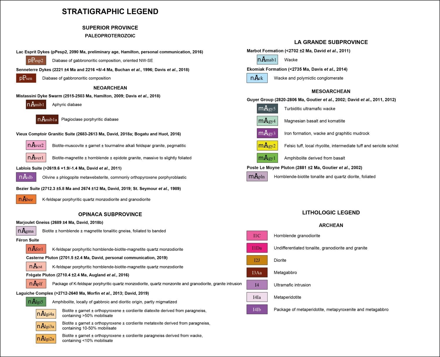
Lithostratigraphy
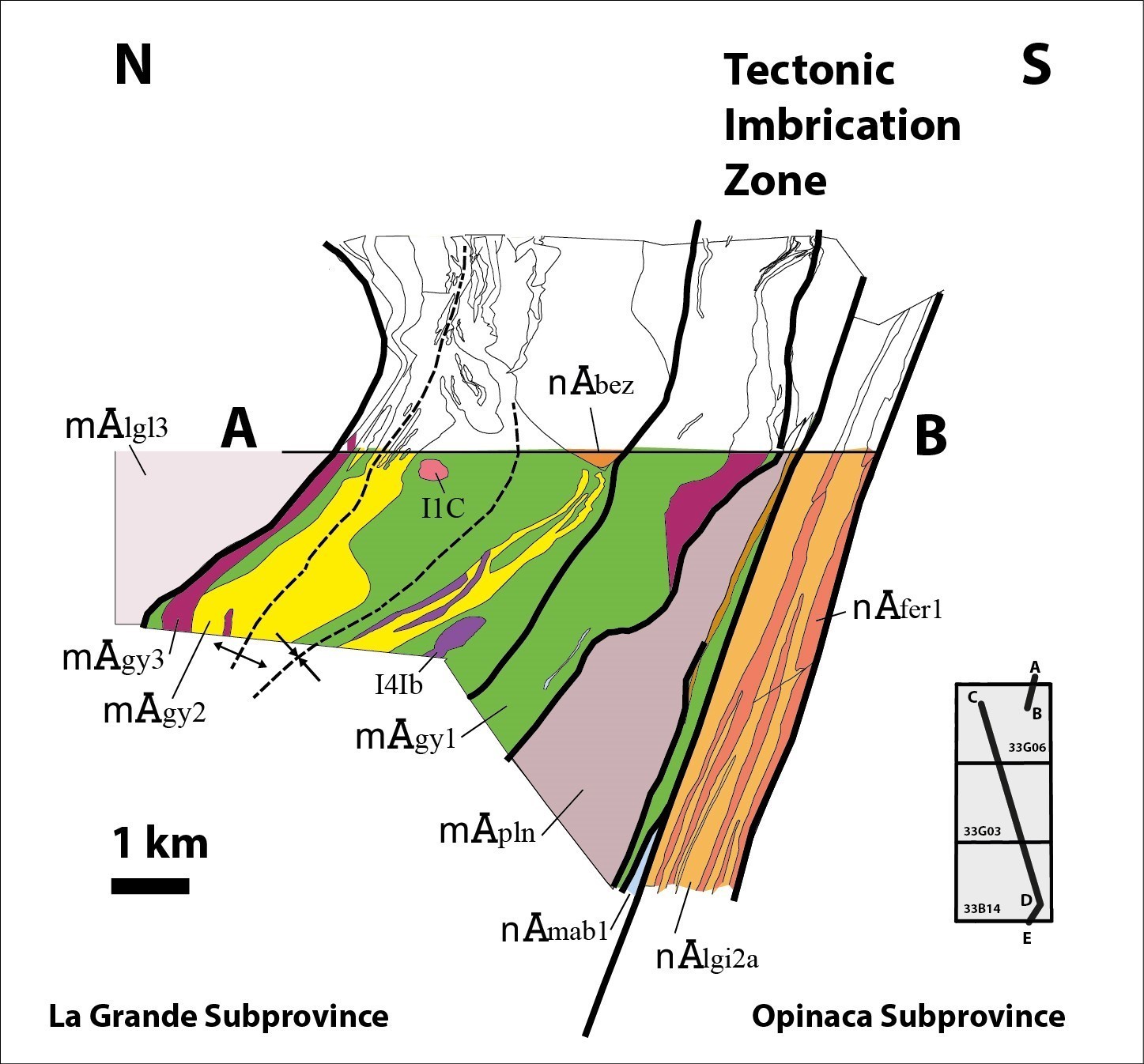
The mapped area is located in the Superior Province, more precisely in the north-central portion of the Opinaca Subprovince, at the contact with the La Grande Subprovince. Lithodemic and lithological units of the Casterne Lake area can thus be divided into three packages:
- units of the La Grande Subprovince;
- units of the Opinaca Subprovince;
- later units belonging to both subprovinces.
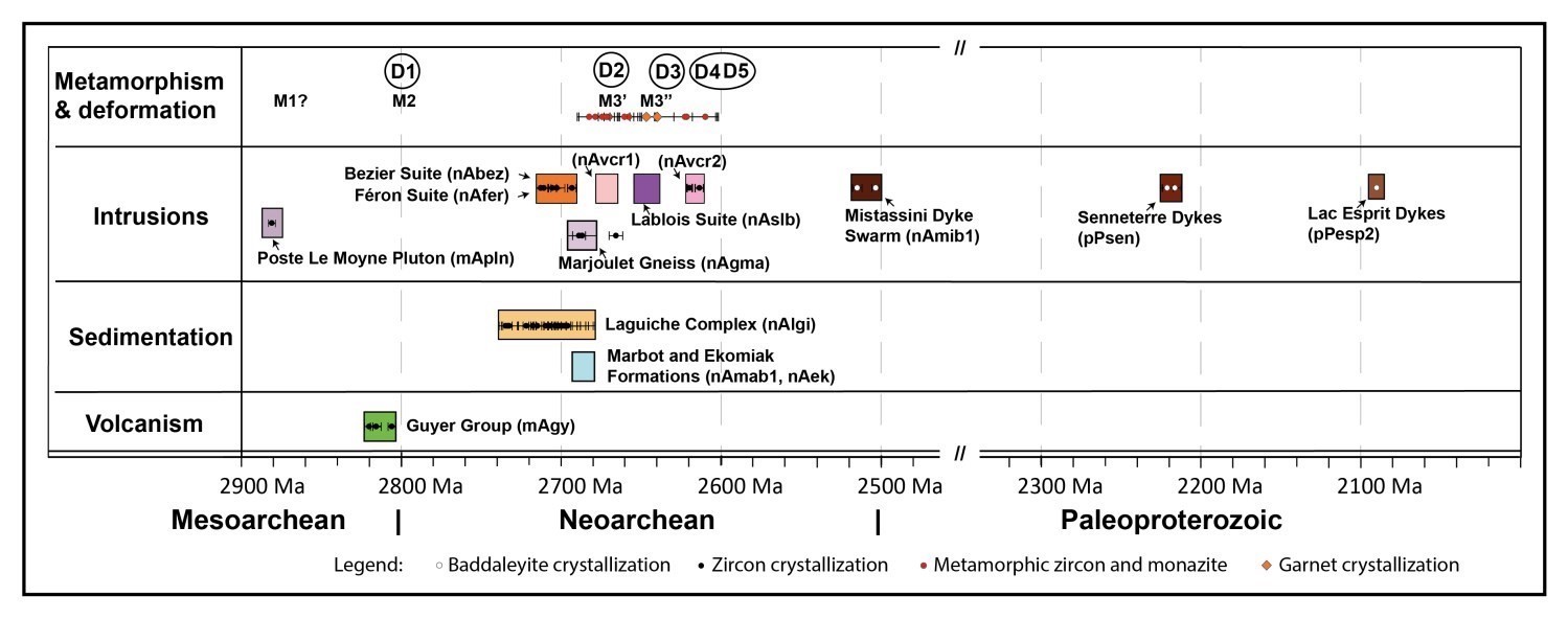
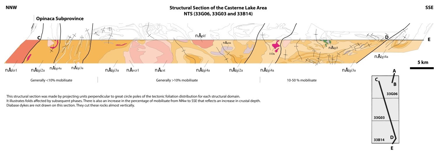
Units of these packages are presented in chronological order of their emplacement. This order was determined from cross-cutting relationships observed in the field and available geochronological data, as shown on the structural section and timeline.
La Grande Subprovince Units
 Mesoarchean (3400-2800 Ma)
Tonalite and quartz diorite units of the Poste Le Moyne Pluton (mApln; 2881 ±2 Ma, Goutier et al., 2002) are the oldest rocks in the area. These outcrop in the NE portion of the map. The edges of plutons, as well as adjacent volcanics of the Guyer Group, are heavily deformed and commonly mylonitized, suggesting a tectonic contact.
The Guyer Group (mAgy; 2820-2806 Ma, Goutier et al., 2002; David et al., 2011b, 2012) is located in the northern part of the mapped area. The abundance of mining exploration work since the year 2000 in this area, coupled with very high resolution magnetic maps (lines every 70 m) and new field observations, has helped to clarify the contacts between units of this group. Amphibolite derived from basalt (mAgy1) is the most common unit. Units of felsic tuff, locally rhyolite, intermediate tuff and sericite schist (mAgy2), iron formation, wacke and graphite mudrock (mAgy3), magnesian basalt and komatiite (mAgy4), and a strip of ultramafic wacke (mAgy5) are also described.
Neoarchean (2800-2500 Ma)
 Three polymictic conglomerate lenses were drawn from mapped outcrops and compiled in exploration company assessment reports in the northern portion of sheet 33G06. The composition of tonalitic-dominant fragments and their grain size (pebble and block) make it possible to assign this polymictic conglomerate to the Ekomiak Formation (nAek; <2735 Ma, Davis et al., 2014). The rock is highly deformed and hosted in Guyer Group basalts, suggesting a tectonic contact. During sedimentation, this conglomerate was possibly unconformably overlying (erosional discordance) rocks of the Guyer Group. Detrital zircon dating and further study (composition of clasts and magnetite) would be required to confirm its belonging to the Ekomiak Formation.
The Marbot Formation (nAmab1; <2702 ±2 Ma, David et al., 2011b) extends to the NE corner of sheet 33G06. A shear zone marks the contact between the Marbot Formation and the Guyer Group, which hosts it. The initial nature of the contact could be a discordance, as suggested by Bandyayera et al. (2011).
Opinaca Subprovince Units
Neoarchean (2800-2500 Ma)
The Laguiche Complex (nAlgi; >2712-2640 Ma, Morfin et al., 2013; David, 2019) covers ~80% of the Casterne Lake area. The contact of the latter with the Guyer Group (La Grande Subprovince; sheet 33G06) is completely obliterated by a shear zone, which is locally overprinted by a large NE-SW fold. Units of paragneiss (nAlgi2a), metatexite (nAlgi3a) and diatexite (nAlgi4a) are observed in the Casterne Lake area. Paragneiss is concentrated in sheet 33G06, while sheets farther south show greater abundance of migmatite characterized by a gradual increase in the proportion of metatexite and diatexite from north to south. In the study area, the Laguiche Complex contains varying proportions of centimetric to metric injections of tonalitic to granitic composition. Orthopyroxene is common, whereas absent from sheets farther west (Goutier, 2018). Some kilometric bands of amphibolite (nAlgi5) are also found in sheet 33B14.
In the Casterne Lake area, the Féron Suite (nAfer1) includes the western part of the Frégate Pluton (nAplf; 2710.4 ±2.4 Ma, Augland et al., 2016), the Casterne Pluton, a new unit located in the centre of the area (nAcst; 2701.5 ±2.4 Ma, David, personal communication, 2019), north of sheet 33G06, as well as several injections parallel to the contact between the two subprovinces. The pluton in the northern part of the Opinaca Subprovince (sheet 33G06) was previously associated with the Bezier Suite; however, it was reassigned to the Féron Suite as does not cut the La Grande Subprovince. All of these intrusions consist mainly of quartz monzodiorite. They intrude into rocks of the Laguiche Complex. The Casterne and Frégate plutons form locally flattened cylindrical masses that dip shallowly towards the ENE. The main foliation in the hosted metasedimentary rocks mould these intrusions, since it was developed after their emplacement.
Several strips of the Marjoulet Gneiss (nAgma; 2689 ±4 Ma, David, 2018b) are scattered throughout the Casterne Lake area. These strips are parallel to regional foliation and are hosted in metasedimentary rocks of the Laguiche Complex. There are more in the study area than in areas farther west. Strips are 1 to 10 km long and 300 m wide. The 2018 mapping campaign extended this unit eastward.
Units Belonging to Both Subprovinces
Neoarchean (2800-2500 Ma)
A pluton of the Bezier Suite (nAbez; 2674 ±12 Ma and 2712.3 ±5.8 Ma, St. Seymour et al., 1989; David, 2019) outcrops in the northern part of the mapped area and cuts rocks of the Guyer Group. It consists of quartz monzodiorite and K-feldspar porphyritic granodiorite.
About 20 ultramafic intrusions averaging a surface area of 0.06 km2 are associated with the Lablois Suite (nAslb; >2619 Ma, David et al., 2011a). They are usually located in or around shear zones cutting the Laguiche Complex, and are more abundant in sheets 33G03 and 33B14. These intrusions consist of little to slightly foliated olivine metawebsterite. They cut paragneiss and migmatite units (metatexite and diatexite).
Some kilometric plutons and pegmatitic metric intrusions of the Vieux Comptoir Granitic Suite (nAvcr; 2683-2613 Ma, David, 2018a; Bogatu and Huot, 2016) cut the Guyer Group, Laguiche Complex, Féron Suite plutons, Marjoulet Gneiss and Lablois Suite, forming a rim around the Casterne Pluton. The area has relatively few tourmaline-muscovite-rich granite (nAvcr2) occurrences compared to areas farther west; some are observed mainly in the La Grande Subprovince, particularly in the Orfée gold-bearing zone (Bogatu and Huot, 2018).
Two NE-SW oriented diabase dykes belonging to the Mistassini Dyke Swarm (2515-2503 Ma; Hamilton 2009; Davis et al., 2018) were identified in the mapped area.
Paleoproterozoic (2500-1600 Ma)
Two diabase dykes belonging to the Senneterre Dykes (pPsen; 2221 ±4 Ma and 2216 +8/-4 Ma, Buchan et al., 1996; Davis et al., 2018), oriented WSW-ENE, cut rocks of the Opinaca Subprovince in the centre of the study area and in the NE portion of sheet 33G06. The Lac Esprit Dykes (pPesp2; 2090 Ma, preliminary age, Hamilton, personal communication, 2016) are also NE-SW oriented, but more discontinuous than the Mistassini Dyke Swarm.
Archean Lithological Units
A group of felsic to ultramafic intrusions have been mapped in the area, but have not been associated with specific lithodemic units. On the geological map, their names are at the bottom of the lithological legend.
A hornblende granodiorite intrusion (I1C) was recognized in the northern portion of sheet 33G06. The 500 m diameter unit is intrusive in metabasalt of the Guyer Group mAgy1 unit. The low magnetic susceptibility of the intrusion and geochemical analyses indicate a granodioritic composition, unlike the syenite proposed by L’Heureux and Chénard (1999).
About ten intrusions of tonalitic to granitic composition (I1Da) cutting the Laguiche Complex have not been attributed to any specific lithodemic unit. Although the observed mineralogical assemblage is similar to that of the Marjoulet Gneiss (biotite-hornblende-magnetite), these intrusions do not exhibit any banding characteristic of the Marjoulet Gneiss.
The diorite unit (I2J) is located directly to the south of the Poste Le Moyne Pluton and occurs as a 7 km-long, 100 m-thick sill. It was traced using outcrops and strippings described by exploration companies (Cayer and Oswald, 2009). This diorite hosts several gold mineralized zones (Guylaine, PLE-10-141, Ilto and Tommy; Cayer and Oswald, 2009). It contains hornblende (40-55%), plagioclase, epidote and sulphides (<5% pyrrhotite-pyrite). It is variably deformed: foliated, sheared or mylonitized.
A package of mafic to ultramafic intrusions (I3Aa, I4, I4Ia and I4Ib) forming 200 m-thick by 2-3 km-long sills was drawn from the mapping work of Stamatelopoulou-Seymour (1975, 1982) and, more recently, of Oswald (2012, 2013, 2014). A detailed description of these units can be found in a report by Goutier et al. (2002).
STRUCTURAL GEOLOGY
The region as a whole was marked by an increase in penetrative deformation approaching the contact between the La Grande and Opinaca subprovinces, as well as south of the Opinaca Subprovince. The mapped area is indicative of polyphase deformation, marked by undulating axial traces of numerous E-W to NE-SW folds. It is also characterized by a generalized dip of linear structures eastward. Regional kilometric folds were drawn from variations in the orientation of the main foliation and topographic lineaments. Together, these structural elements mark five episodes of ductile deformation in the area.
Shear Zones
Several E-W to WNW-ESE oriented shear zones crosscut the area. They were drawn from the outcrop deformation intensity map and the tilt angle image derived from high-resolution aeromagnetic surveys. Shear zones define highly foliated to mylonitic areas with a minimum thickness of tens of metres. They were associated with the fourth episode of deformation (see below). The most important, the Quentin Shear Zone (QSZ), is related to overthrusting of La Grande Subprovince rocks over Opinaca rocks.
Deformation Phases and Tectonic Evolution
Structures associated with bedding (S0) and foliation (S1) are limited to volcanic units of the La Grande Subprovince. The regional tectonic grain, corresponding to the main foliation S2, is defined in both subprovinces by the alignment of biotite and amphibole.
The first episode of deformation, known as D1, is a compression event that took place after the formation of the Guyer Group and before the emplacement of the Langelier Complex. A second deformation event (D2) is responsible for the regional E-W tectonic grain and the main foliation S2 in rocks of the Guyer Group and Laguiche Complex. The D2 episode is interpreted as synchronous to regional metamorphism referred to as M3.

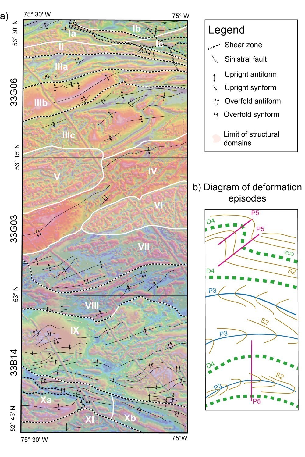
The third episode of deformation (D3) is responsible for the folding of S2 foliations. This episode is linked to a series of kilometre-scale P3 folds observed in the Opinaca Subprovince, whose axial traces are oriented E-W. P3 folds are locally transposed by shear zones oriented E-W and WNW-ESE to NE-SW during a fourth deformation event (D4). A fifth episode of ductile deformation (D5) corresponds to NE-SW oriented P5 folding that affects shear zones, particularly in contact with the Opinaca and La Grande subprovinces. It reactivates some shear zones and affects rocks of the Vieux Comptoir Granitic Suite (Bogatu and Huot, 2016). This event is also associated with N-S oriented P5 folds that undulate P3 axial traces in the Opinaca Subprovince and cause a double vergence eastward and westward.
Subsequently, the entire Eeyou Istchee James Bay region was affected by several episodes of brittle deformation marked by the presence of NE-SW and WSW-ENE oriented transverse faults. These structures are associated with the emplacement of the various diabase swarms of the region.
Structural Domains
The mapped area was divided into 11 structural domains based on the attitude of measured structures, the tectonic grain observed on magnetic field maps and lithological criteria. Several subdomains were defined based on the similarity and coherence of structures.
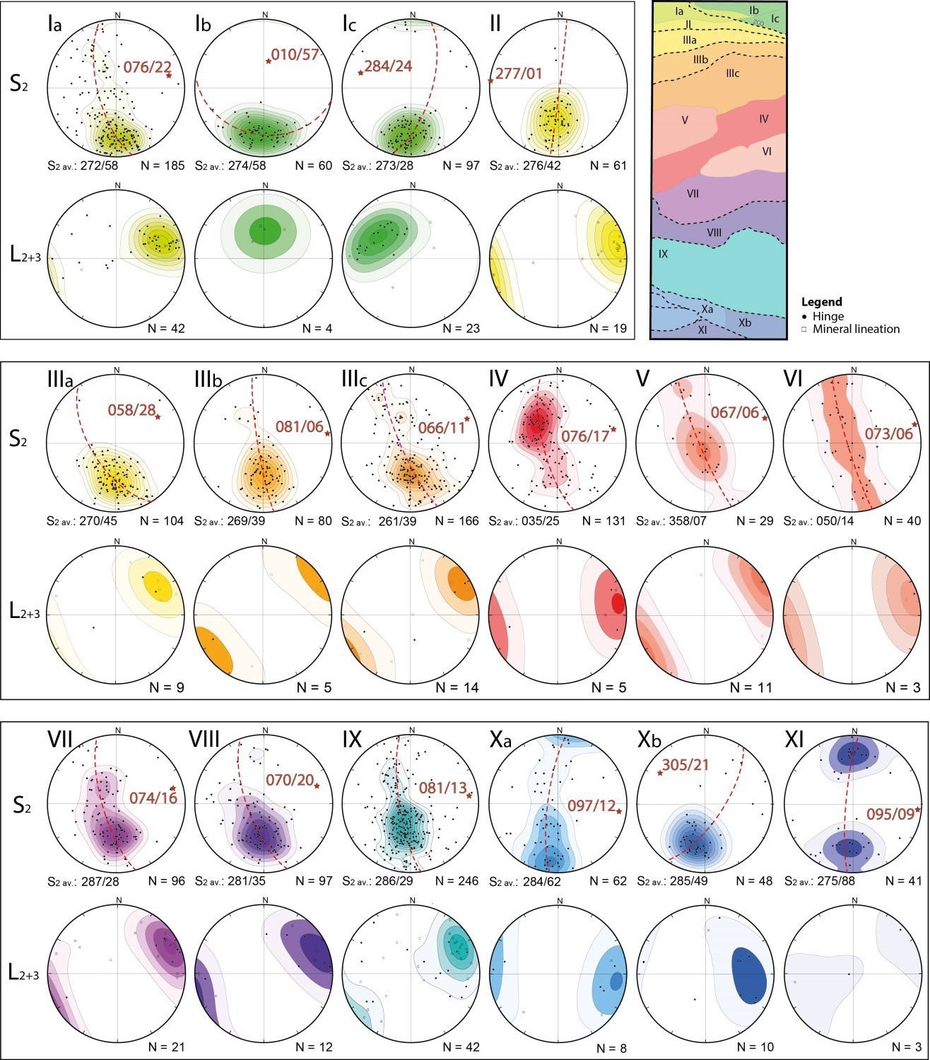
Domain I corresponds to the QSZ area. S2 foliations of the three subdomains of this area have similar average orientations (E-W and 60° dip northward).
- subdomain Ia consists of rocks of both subprovinces affected by the ENE-dipping synform associated with large regional Z-folding (P5). Hinges and mineral lineations measured in this area correspond to the pole of the great circle passing through S2 poles (076°/22°);
- subdomain Ib is more straight-lined and is less affected by late Z-folding. Foliations are E-W oriented and dip northward (010°/57°). The few mineral lineations measured fall in the northward dipping foliations;
- subdomain Ic also shows an S2 foliation with an average E-W orientation and northward dip. Fold hinges dip towards the NW (284°/24°).
S2 planar structures, generally oriented E-W and ex variable northward dip, dominate in domain II (average plane 273°/42°). Metamorphic lineations are almost horizontal, generally plunging towards the ENE.
Domain III is characterized by a decrease in deformation intensity from north to south. Three subdomains are separated by shear zones and show similar S2 foliation average planes oriented E-W with a northward dip. Folds in subdomain IIIa are isoclinal, tilted to the south, their axial traces are oriented E-W and fold axes plunge towards the ENE (058°/28°). Subdomain IIIc shows cylindrical folds, open, upright or slightly overturned southward and dipping shallowly towards the ENE (066°/11°). S2 foliations are spread over a great circle. Subdomain IIIb is an intermediary between adjacent subdomains with tighter folds.
Domain IV S2 foliations are the only ones in the mapped area to have a south-dipping average plane (035°/25°). Rocks of this domain are trapped between more competent masses of Féron Suite intrusions. Folds are upright to overturned towards the north and dipping shallowly towards the ENE.
Domains V and VI are related respectively to the Casterne Pluton and Frégate Pluton. They are ellipsoid to cylindrical and dip very shallowly towards the ENE (067°/06° and 073°/06°). Shallow-dip foliations measured in intrusive rocks of the Féron Suite are oriented concentrically in relation to the contact with hosted paragneiss. In the Frégate Pluton, foliation is usually E-W and has a variable dip towards the south or north.
Domain VII shows upright folds with subhorizontal hinges that weakly undulate and generally point eastward (or more locally westward).
Domain VIII folds dip moderately towards the NE (070°/20°) and are mostly overturned southward. This domain is delineated north and south by shear zones well visible on aeromagnetic maps.
Domain IX is distinguished by a series of upright to overturned southward folds, tight to undulating and shallow plunging eastward.
Domain X is characterized by the presence of several shear zones. Folds are transposed according to these deformation zones. The eastern part of the domain includes folds steeply dipping westward, while the western part shows folds shallowly dipping eastward. This double dip highlights the third phase of N-S P5 folding.
Domain XI, the southernmost, is less deformed than domain X. The measured fold axis dips slightly eastward. The distribution of S2 foliation poles on the great circle suggests a symmetrical, upright and chevron fold.
METAMORPHISM
The Casterne Lake area has a polymetamorphic history with at least one Mesoarchean (M1) and one Neoarchean (M2) episode that affected volcanic and sedimentary rocks of the Guyer Group (Goutier et al., 1999; Goutier et al., 2002; Goutier, 2018). A final episode of regional metamorphism (M3) has affected the entire region and is responsible for assemblages shown on the metamorphism map. This major episode shows two distinct peaks: a first low-pressure high-temperature event (M3’) at 2670 Ma, followed by cooling; then a second event (M3’’) at 2645 Ma associated with barrovian-type metamorphism and isothermal cooling (Côté-Roberge, 2018).
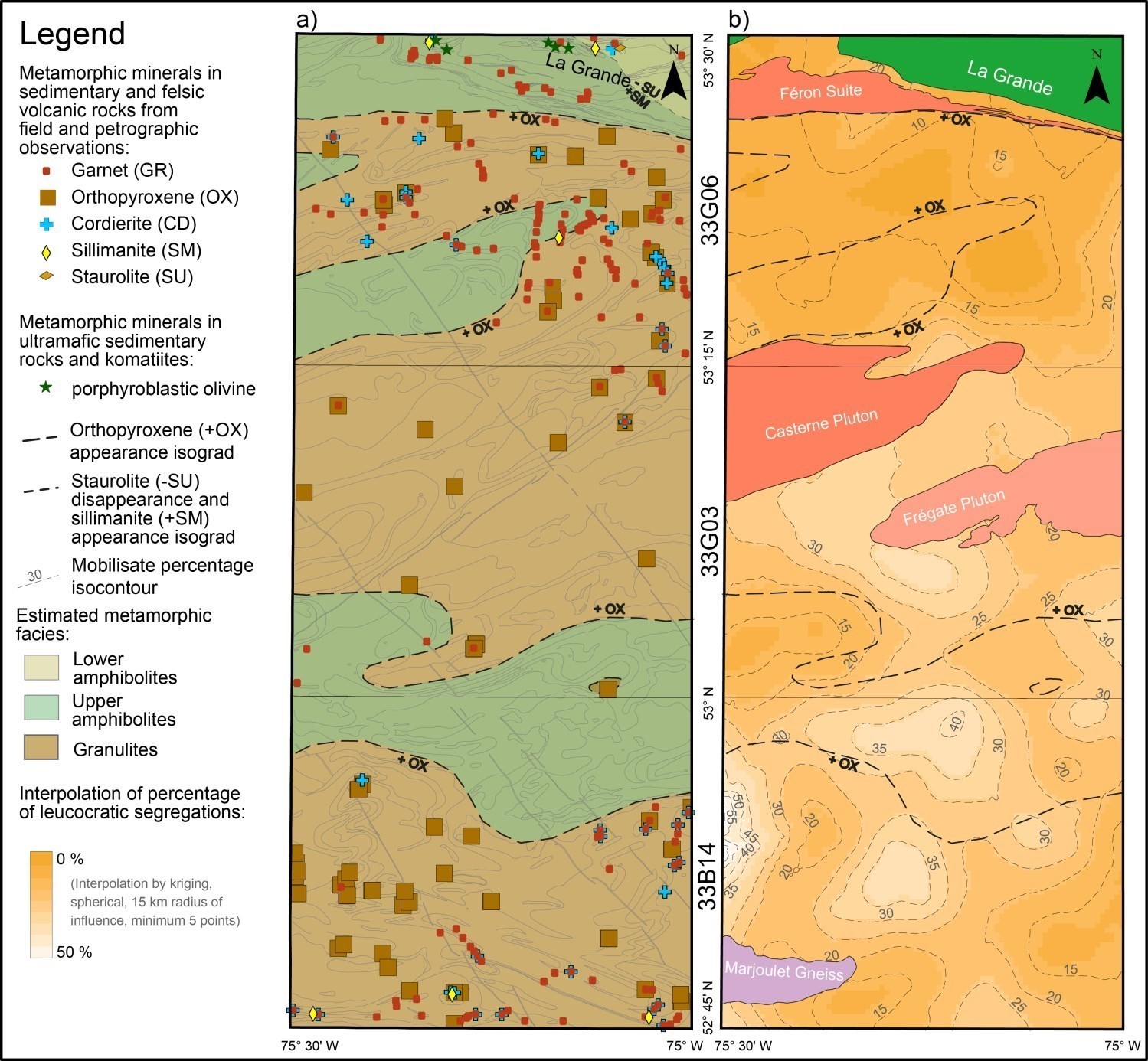
The presence of minerals such as cordierite, staurolite, sillimanite, garnet and muscovite in Guyer Group wackes and felsic tuffs attests to lower amphibolite facies metamorphism (Goutier et al., 2002). Metamorphic olivine porphyroblasts are observed in ultramafic sedimentary rocks (Stamatelopoulou-Seymour and Francis, 1980) and in komatiites of the Guyer Group. Biotite and amphibole define primary foliation, while porphyroblasts of garnet, cordierite and olivine are late tectonic (Goutier et al., 2001). Basalts in the Orfée mineralized zone show the typical garnet-hornblende-plagioclase assemblage of the upper amphibolite facies (Bogatu and Huot, 2016; Bogatu, 2017).
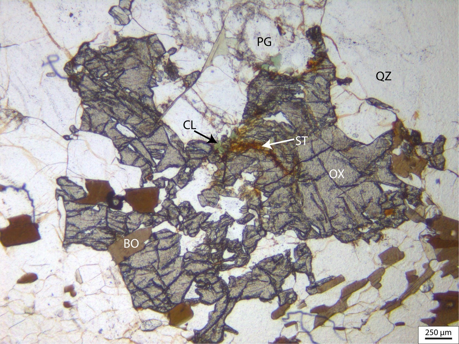
Paragneiss and migmatites of the Laguiche Complex show higher metamorphism than Guyer Group rocks, with a quartz-plagioclase-biotite ± hornblende ± K-feldspar ± garnet ± cordierite ± orthopyroxene ± sillimanite assemblage, as well as a variable degree of partial melting, indicating upper amphibolite facies to granulite facies metamorphism.
The metamorphic map shows the location of metamorphic minerals observed in thin sections and outcrops in rocks of the Laguiche Complex and Guyer Group, the location of olivine porphyroblasts of the Guyer Group and the isograd drawn from their distribution. The isograd’s irregular trace associated with the appearance of orthopyroxene demonstrates highly discontinuous metamorphism, repeatedly moving from the higher amphibolite facies to the granulite facies. This isograd corresponds in several locations to regional shear zones. Orthopyroxene and sillimanite appearance isograds converge to the contact between the Opinaca and La Grande subprovinces in the NE portion of the map where metamorphism change from the lower amphibolite facies to the granulite facies over a distance of only 2 km. The metamorphic gradient is therefore steeper than in map sheets to the west.
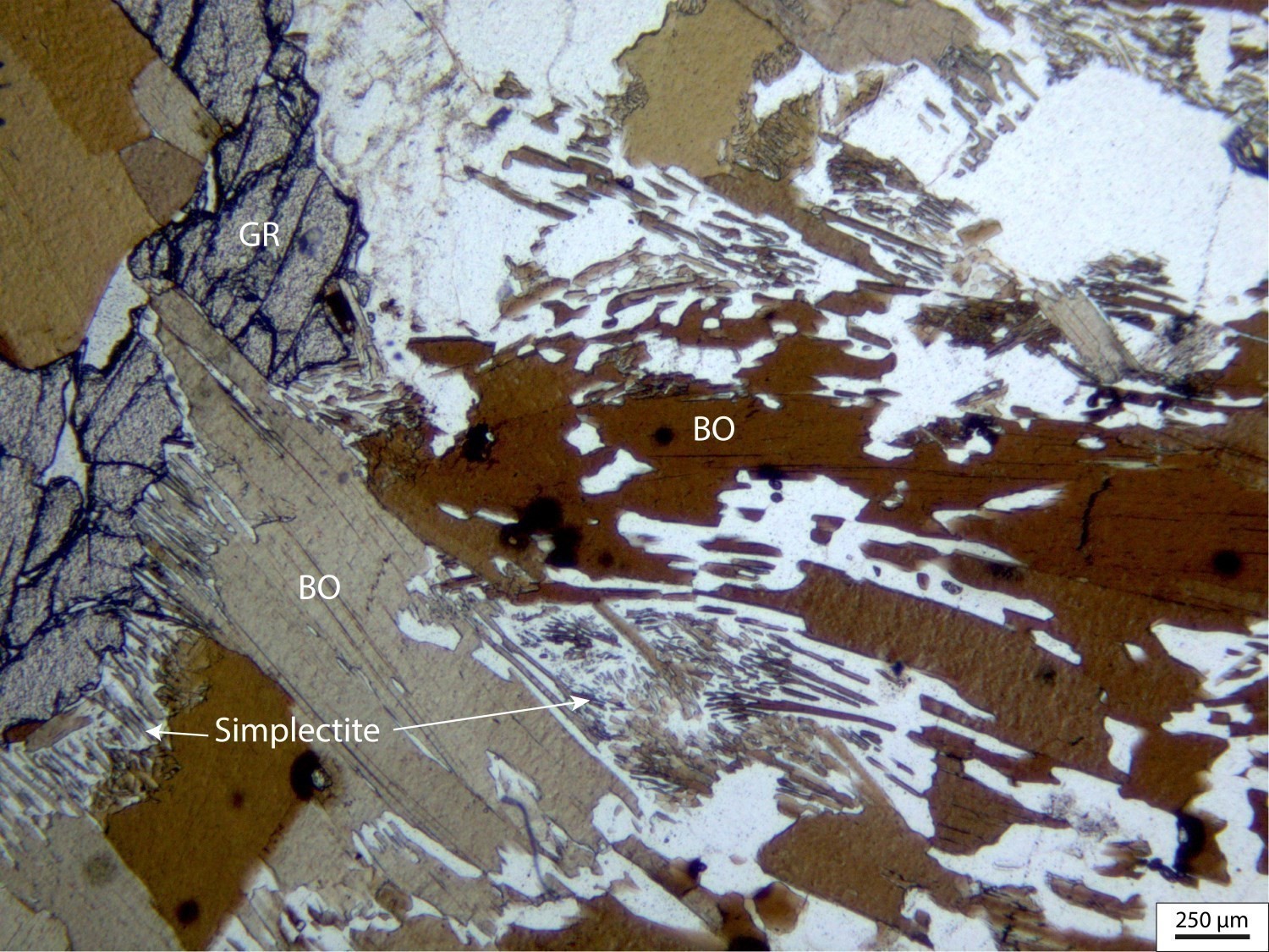
Garnet is observed throughout the mapped territory, although sparser in sheet 33G03. In thin sections, it is poikiloblastic and its growth is mostly late-kinematic to post-kinematic compared to the main foliation. Cordierite is observed as millimetric porphyroblasts, post-kinematic to main foliation, isolated or forming rims around garnets. Its distribution is limited to sheet 33G06 and the southern portion of sheet 33B14. Muscovite replaces cordierite locally. Sillimanite is very locally observed and occurs as prisms or fibrolite. Anatectic liquid pseudomorphs are observed in ~20 petrographic samples as simplectic intergrowth between biotite and plagioclase (Holness, 2008).
 An interpolation of the mobilisate percentage of Laguiche Complex migmatites is shown on the metamorphic map. This percentage is increasing from north to south. Migmatite zones exhibiting a high percentage of mobilisate (unit nAlgi4a) show no spatial correlation with the occurrence of orthopyroxene. Ultrametamorphic granite derived from the melting of paragneiss was observed in sheet 33B14. Large plutonic masses (Féron Suite and Marjoulet Gneiss) show the same metamorphic facies as the Laguiche Complex, since their intrusion (2710 ±2.4 Ma) predates regional metamorphism (Augland et al., 2016). In both subprovinces, assemblages associated with the M3 regional metamorphic facies have been retrograded in some places to the greenschist facies and lower amphibolite facies. Orthopyroxene is commonly highly altered to amphibole, chlorite, serpentine and smectite. Variable degrees of chloritization, damouritization, and pinnitization of biotite, feldspar and cordierite can be attributed in part to retrogressive metamorphism or late alteration, possibly Paleoproterozoic, synchronous with the emplacement of diabase dykes.
Economic Geology
The Casterne Lake area has prospective zones for these three (3) types of mineralization:
- base metal massive sulphide mineralization associated with volcanic rocks;
- copper mineralization in altered paragneiss of the Laguiche Complex;
- gold mineralization of various types:
- stratiform gold mineralization in iron formations;
- mineralization in orogenic gold veins;
- disseminated and replacement gold mineralization;
- gold-bearing disseminated sulphide mineralization associated with volcanic rocks.
These prospective zones include known mineralized zones or new occurrences. The following table presents analytical results for fifty-four (54) known mineralized zones in the area, including a new mineralized zone discovered as part of our work:
| Name | Contents |
|---|---|
| Undetermined type of mineralization | |
| Shlolly | 0.765% Cu (G) |
| Name | Content |
|---|---|
| Orogenic-type lode gold mineralization | |
| Galexis | 2.8 ppm Ag over 1.2 m (R); 4900 ppb Au (G); 20 200 ppm Cu over 0.3 m (R) |
| Guyer-Sud 81210 | 6.3 ppm Ag (G); 82 ppb Au (G) |
| Éch. 168114 | 134 ppm Ag (G); 6580 ppb Au (G); 1300 ppm Cu (G); 11 900 ppm Pb (G) |
| Éch. 230541 | 18 170 ppb Au (G) |
| Gold mineralization in iron formations | |
| Lemoyne-Extension | 6220 ppb Au over 1 m (R) |
| Orfée | 67 350 ppb Au over 1 m (R); Resource: 203 483 metric tonnes at 14.5 g/t Au |
| Orfée Est | 10 530 ppb Au over 1.1 m (D) |
| PLE-98-05 | 3520 ppb Au over 0.4 m (D) |
| Disseminated and replacement gold mineralization | |
| Guylaine | 2400 ppb Au over 1 m (R) |
| ILTO | 3540 ppb Au over 3 m (R) |
| PLE10-141 | 1230 ppb Au over 1 m (D) |
| Éch. 168205 | 1170 ppb Au (G) |
| Éch. 351243 | 1470 ppb Au (G) |
| Mineralization in granitic pegmatites | |
| Upin1 | 28 816.9 ppm REE (G); 2440 ppm Th (G) |
| Upin10 | 3546.1 ppm REE (G); 1520 ppm Th (G); 2193 ppm U (G) |
| Upin13 | 1050 ppm Th (G); 2696.64 ppm U (G) |
| Upin14 | 2050 ppm Mo (G); 661.44 ppm U (G) |
| Upin2 | 105 858.9 ppm REE (G); 8530 ppm Th (G); 1620 ppm Y (G) |
| Upin3 | 2106.3 ppm REE (G); 1770 ppm Mo (G); 593 ppm Th (G); 1170.24 ppm U (G) |
| Upin4 | 1430 ppm Th (G); 1560.32 ppm U (G) |
| Upin5 | 797.12 ppm U (G) |
| Upin6 | 10 001.3 ppm REE (G); 979 ppm Th (G); 2136.96 ppm U (G) |
| Upin7 | 563 ppm Th (G); 1521.5 ppm U (G) |
| Upin8 | 10 940.5 ppm REE (G); 484 ppm Th (G); 2323.52 ppm U (G); 1800 ppm Y (G) |
| Upin9 | 918 ppm Th (G); 4536.8 ppm U (G) |
| Éch. 5510677 | 13 097.6 ppm REE (G); 1820 ppm Th (G) |
| Éch. 5510682 | 660 ppm U (G) |
| Éch. 55190060 | 2851.3 ppm REE (G); 849 ppm Th (G) |
| Éch. 5519867 | 471 ppm Pb (G); 587 ppm Th (G); 1300 ppm U (G) |
| ÉCH. 5519926 | 7650 ppm Pb (G); 2810 ppm Th (G); 17 700 ppm U (G) |
| Éch. 68790037 | 16 204.3 ppm REE (G); 1840 ppm Th (G) |
| Éch. 8790069 | 467.5 ppm U (G) |
| Éch. 68790158 | 57 959.1 ppm REE (G); 4840 ppm Th (G); 1230 ppm Y (G) |
| Éch. 68790182 | 932.8 ppm U (G) |
| Éch. 68790194 | 467 ppm Th (G) |
| Éch. 68790215 | 1659 ppm REE (G); 684 ppm Th (G); 500.32 ppm U (G) |
| Éch. 68790236 | 568.16 ppm U (G) |
| Éch. 68790270 | 1000.64 ppm U (G) |
| Éch. 68790285 | 831.04 ppm U (G) |
| Éch. 68790300 | 1941.92 ppm U (G) |
| Éch. 6879281 | 1540 ppm Th (G); 534.24 ppm U (G) |
| Chromite mineralization in mafic and ultramafic rocks | |
| Éch. 187116 | 9307 ppm Cr (G) |
| Base metal massive sulphide mineralization associated with volcanic rocks | |
| Plug | 1.2 ppm Ag over 0.2 m (D); 33 200 ppm Zn over 0.2 m (D) |
| Poste Lemoyne | 6 ppm Ag over 0.3 m (D); 1052 ppb Au (G); 473 ppm Cu (G); 9820 ppm Zn (G) |
| TR-PL3-10-018 | 29.4 ppm Ag (G); 36 800 ppm Cu (G); 17 800 ppm Zn (G) |
| Gold-bearing sulphide mineralization associated with volcanic rocks | |
| Arséno | 13.6 ppm Ag (G); 67 760 ppm As (G); 11 830 ppb Au (G); 1380 ppm Cu over 1 m (R); 6500 ppm Zn (G) |
| Le Moyne-12319 | 1920 ppb Au (G) |
| Lemoyne-hydro | 5 ppm Ag (G); 305 ppb Au (G); 219 ppm Cu (G); 1060 ppm Zn (G) |
| Schistes à séricite | 14 ppm Ag (G); 1510 ppb Au (G); 5450 ppm Cu (G); 1640 ppm Zn (G) |
| TR-PL-09-035 | 1270 ppb Au over 2 m (R) |
| Éch. 169918 | 24.3 ppm Ag (G); 1440 ppb Au (G) |
| Gold-bearing disseminated sulphide mineralization associated with volcanic rocks | |
| Tommy | 14.57 g/t Au over 1 m (D) |
| Undetermined type of mineralization | |
| Éch. 182976 | 1780 ppb Au (G) |
(D): diamond drilling; (G): selected sample; (R): channel–chip sample
The table of lithogeochemical analyses of metals of economic interest provides the location, description, and analytical results for thirty-five (35) samples selected to assess the economic potential of the area.
New Prospective Zone for Zinc, Copper, Silver and Gold Mineralization Associated with Felsic Volcanics of the Guyer Group
The Lac Casterne 1 prospective zone values the largest felsic volcanic unit located in the centre of the Guyer Group. This zone groups horizons of felsic volcanics, volcaniclastics and mudstone that have anomalous and showing values of base and precious metals. Sericitization is common and, if abundant, leads to the formation of sericite schists. At the northern contact of the felsic volcanic unit (mAgy2) lies a horizon rich in pyrite, pyrrhotite and graphite. In places, the rock is mineralized in sphalerite and chalcopyrite (e.g., 1.24% Zn, 3.68% Cu and 29.4 ppm Ag; éch. 170401, Cayer, 2010). This mineralized portion of the unit represents a stratigraphic marker for the exploration of volcanogenic massive sulphide (VMS) mineralization. Further west, this horizon is not mineralized, but includes graphitic mudstone and iron formation interstratified between felsic volcanics and sommital basalts. Graphitic and sulphidic conductor horizons correspond to electromagnetic anomalies on the map (Oakes and Lavoie, 1976; Simard, 1999). In sheet 33G11, the Guyer-SW, Bertha and Lemoyne-Hydro mineralized zones are located along the same marker horizon. A lithogeochemical study using data from Sigéom (sheets 33G06 and 33G11) identified sericite-rich alteration zones and compared them with the Doyon-Bousquet area known for its gold SMV mineralization (Dubé et al., 2007).
New Copper Mineralization in Altered Paragneiss of the Laguiche Complex
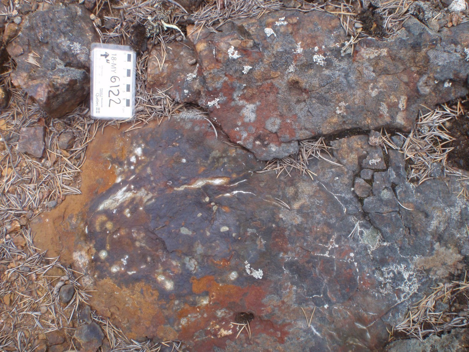
The Lac Casterne 2 prospective zone is characterized by graphitic paragneiss of the Laguiche Complex showing heterogeneous alteration as irregular centimetric clusters rich in hornblende and diopside (up to 20%), accompanied by chlorite, calcite and sulphides. These zones conformable with regional foliation are a few metres thick and extend laterally over a few tens of metres. They coincide with areas of strong magnetic contrast. The hornblende-diopside assemblage is interpreted as the product of metamorphism of an early alteration in chlorite, calcite and sulphides. It is commonly associated with pyrite (1%), pyrrhotite (4%), chalcopyrite (1%) and disseminated malachite mineralization. Our work uncovered anomalous or showing copper values (7.65% Cu, Shlolly mineralized zone, unique sample number 2018072501).
Gold-Bearing Corridor in the Northern Casterne Lake Area
 The Lac Casterne 3 prospective zone features gold-bearing corridors in the northern part of Casterne Lake. The largest of these corridors is located at the highly distorted interface between the La Grande and Opinaca subprovinces. It was discovered in 1998 (Chénard, 1999; Goutier et al., 2002) and includes structural imbrications of basalt (mAgy1), iron formation, wacke and graphitic mudrock (mAgy3), as well as dioritic intrusions (I2J). Gold mineralization occurs in a number of forms, including stratiform gold mineralization in iron formations, orogenic-type gold veins, disseminated and replacement gold mineralization, and gold-bearing disseminated sulphides associated with volcanic rocks. Significant anomalous and showing values are observed over nearly 30 km in length (work from 1998 to 2010). The most significant mineralization is associated with structural traps (e.g., fold hinges) in an iron formation and in a graphitic mudrock of the Guyer Group mAgy3 unit (Orfée deposit, ~0.2 Mt at 14.5 g/t Au, Bogatu, 2017).
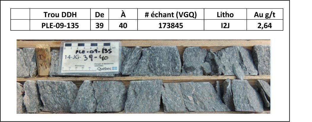
There is also gold mineralization associated with finely disseminated sulphides (<2% pyrite-pyrrhotite) in diorite (e.g., Ilto mineralized zone) and in adjacent basalt (Tommy mineralized zone). This diorite is more or less deformed (weak to mylonitic). Mineralization would be early since it is concentrated in diorite that is virtually undeformed or altered. At the western end of this prospective zone, in sheet 33G06, gold mineralization is hosted in quartz veins (e.g., Galexis mineralized zone) cutting basalt of the Guyer Group. This area is affected by the late, large-scale asymmetric Z-folding phase (see the structural geology chapter). These folds affect the gold-mineralized shear zone at the contact between the two subprovinces. This setting favours the formation of additional structural traps in hinge areas of Z-folds.
Chromite Mineralization in Mafic and Ultramafc Rocks
Ultramafic intrusions from the Casterne Lake area are located primarily in the northern portion of sheet 33G06. Lithological units I4, I4Ia and I4Ib are commonly rich in chromite.
Only one mineralized zone was identified in this area (Éch. 187116). The number of complete analyses of ultramafic rock with precise location is limited (22 analyses of extrusive rock and 29 analyses of intrusive rock). There appears to be potential for Ni-Cu mineralization in ultramafic rocks cutting sulphide-rich rocks of the Guyer Group (some horizons of units mAgy2 and mAgy3).
Undetermined Type of Mineralization
The Éch. 182976 gold-bearing zone is hosted in silicified paragneiss mineralized in pyrrhotite-pyrite (Cayer, 2007). There is insufficient information to determine the type of mineralization. Three samples collected near (<10 m) the mineralized zone yielded <5.3 ppb Au (unique sample numbers 2009023806, 2018072404 and 2018072487).
| Authors | Myriam Côté-Roberge, GIT, M.Sc. Myriam.Cote-Roberge@mern.gouv.qc.ca Jean Goutier, P.Geo., M.Sc. |
| Geochemistry | Fabien Solgadi, P.Geo., Ph.D. |
| Geophysics | Siham Benhamed, GIT, M.Sc. Rachid Intissar, P.Geo., M.Sc. |
| Potential assessment | Hanafi Hammouche, P.Geo., M.Sc. |
| Logistics | Marie Dussault Clotilde Duvergier, GIT |
| Geomatics | Julie Sauvageau Karine Allard |
| Template and content compliance | François Leclerc, P.Geo., Ph.D. |
| Coaching/mentoring and critical review | James Moorhead, P.Geo., M.Sc. |
| English version | Céline Dupuis, P.Geo., Ph.D. |
| Organism | General direction of Géologie Québec, Ministère de l’Énergie et des Ressources naturelles, Government of Québec |
Acknowledgements:
This Geological Bulletin was made possible through the cooperation of many people who actively took part in the various stages of the project. We would like to thank geologists in training Alban Duvernois, Manuel Perron-Racine and Maxym-Karl Hamel-Hébert, as well as students Ehouman Koffi Parterne, Judith Gauriau, Julien Lauret, Madeleine St-Cyr, Marat Guira and Nathanaël Kirch. We would like to acknowledge the excellent work of cook Daniel Morissette and of Dany Trudel in overseeing the installation and dismantling of the camp. Transportation in the field was provided by Héli-Inter. Pilot Hérvé Becker and mechanics Yannik Vary, Marc Aubertin and Alexis Chamberland performed their work effectively and professionally.
References
Publications Available Through Sigéom Examine
Other publications
3 mars 2019